The Largest Countries In Asia By Area
Asia is the largest continent on Earth by land area, covering approximately 44,579,000 square kilometers (about 30% of the world's total land area). It is also home to roughly 4.8 billion people, or close to 58% of the global population. The continent contains 48 sovereign countries, several of which rank among the largest nations on the planet by area. The ten countries below are the largest in Asia, ranked by the share of their territory that sits within the continent. The full list of all 48 Asian countries, with capitals and area figures, follows in the table at the end of the article.
- Russia (Asian portion) - 13,100,000 sq. km
- China - 9,596,961 sq. km
- India - 3,287,263 sq. km
- Kazakhstan (Asian portion) - 2,455,034 sq. km
- Saudi Arabia - 2,149,690 sq. km
- Iran - 1,648,195 sq. km
- Mongolia - 1,564,116 sq. km
- Indonesia (Asian portion) - 1,472,639 sq. km
- Pakistan - 881,913 sq. km
- Turkey (Asian portion) - 747,272 sq. km
The 10 Largest Countries in Asia
1. Russia
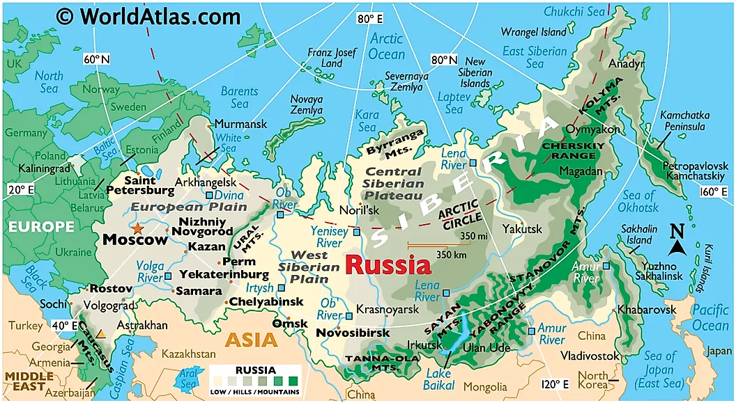
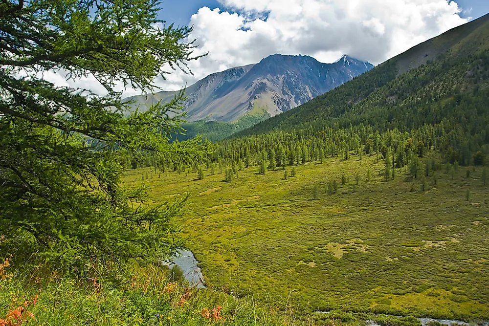
Russia is the largest country in Asia and the largest country in the world by total area, covering 17,098,246 square km (6,601,668 square miles) across both Asia and Europe. Roughly 13,100,000 square km of that total sits east of the Ural Mountains in the Asian portion, and the country as a whole spans 11 time zones across roughly 5,000 miles of east-west territory between Kaliningrad on the Baltic and Kamchatka on the Pacific. The capital is Moscow. The current population is approximately 143 million. Russia encompasses tundra in the north, taiga across most of Siberia, mixed forests and steppes through its central regions, and mountain systems along its southern and eastern borders. The country has nearly 40 UNESCO biosphere reserves to help protect that diversity, and Lake Baikal in Siberia is the deepest lake in the world.
2. China
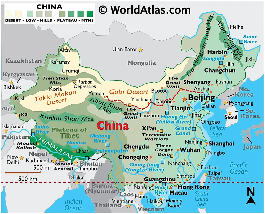
China covers approximately 9.6 million square km (3.7 million square miles), making it the second largest country in Asia and the fourth largest in the world. The capital is Beijing. China's population sits at roughly 1.41 billion, having peaked in 2022 at about 1.426 billion before beginning a long-projected decline driven by record-low fertility. In April 2023, India surpassed China to become the world's most populous country. China contains an unusually wide range of physical geography, including the Tibetan Plateau in the west, the Gobi Desert and Inner Mongolian grasslands in the north, the subtropical forests of the south, and an extensive Pacific coastline. Mount Everest sits on the country's border with Nepal. Administratively, China consists of 22 provinces, 5 autonomous regions, 4 directly controlled municipalities, and 2 special administrative regions.
3. India
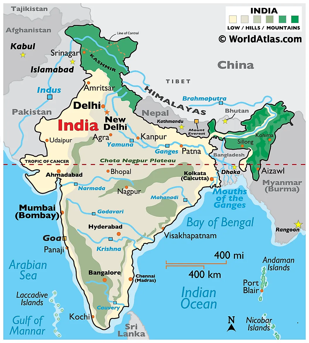
India is the third largest country in Asia by area, at approximately 3,287,263 square km (1,269,219 square miles). The capital is New Delhi. India's population is approximately 1.45 billion, and the country surpassed China in April 2023 to become the most populous nation in the world. India occupies the bulk of the Indian Peninsula, with coastlines along the Arabian Sea, the Bay of Bengal, and the Indian Ocean. The country's interior contains the Himalayan ranges along the northern border, the Thar Desert in the northwest, the Indo-Gangetic Plain across the north and east, and the Deccan Plateau through the south. India's federal structure includes 28 states and 8 union territories.
4. Kazakhstan
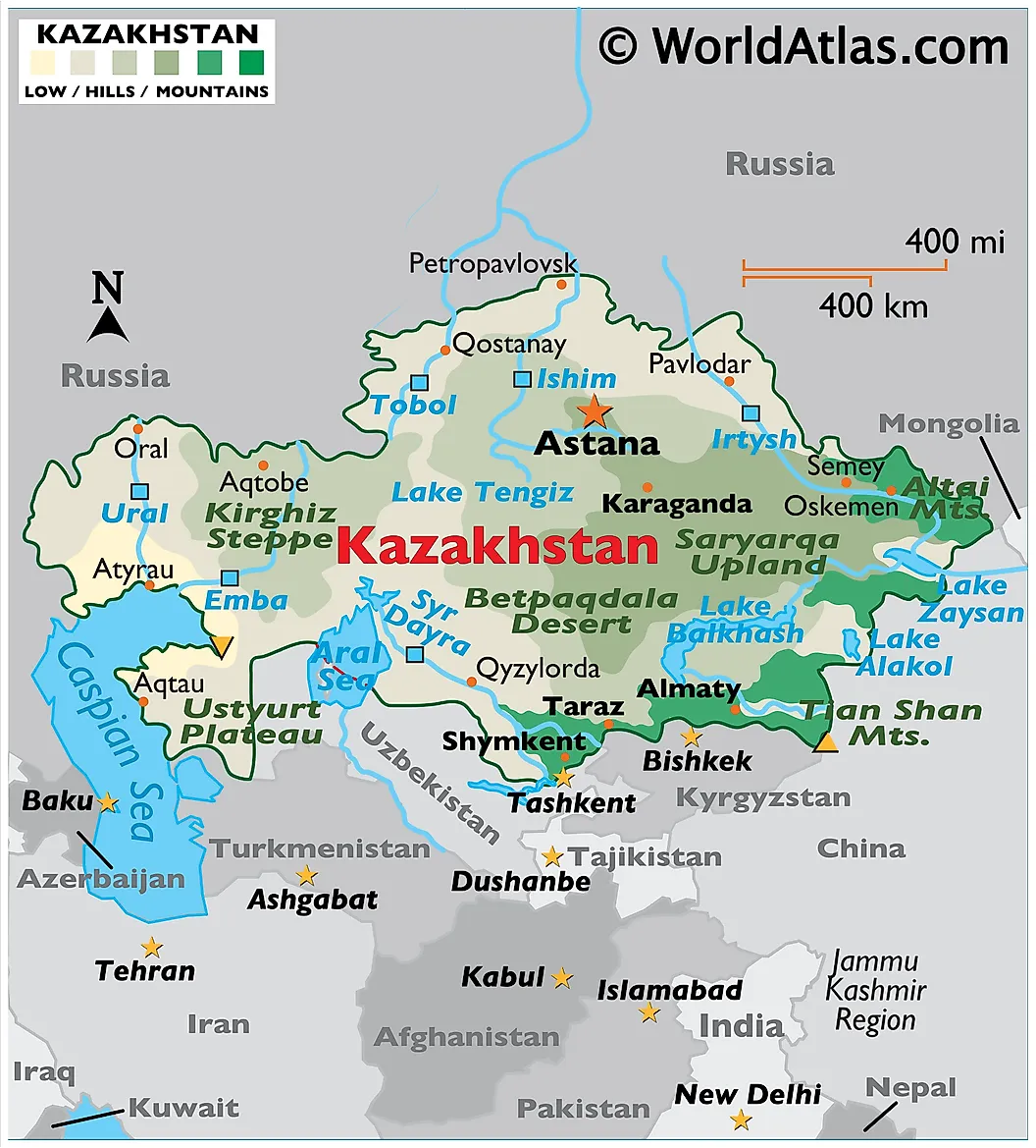
Kazakhstan covers 2,724,900 square km (1,052,090 square miles) total, of which about 2,455,034 square km lies within Asia (the remainder is in Eastern Europe west of the Caspian and Ural River). The capital is Astana, and the largest city is Almaty. The population is approximately 20.4 million, made up predominantly of ethnic Kazakhs along with a significant Russian minority. Kazakhstan is the largest landlocked country in the world and shares borders with Russia, Uzbekistan, Kyrgyzstan, Turkmenistan, China, and the Caspian Sea. The country contains the Kazakh Steppe, the largest dry steppe region in the world at roughly 804,500 square km, along with the Tian Shan and Altai mountain ranges along its eastern borders.
5. Saudi Arabia
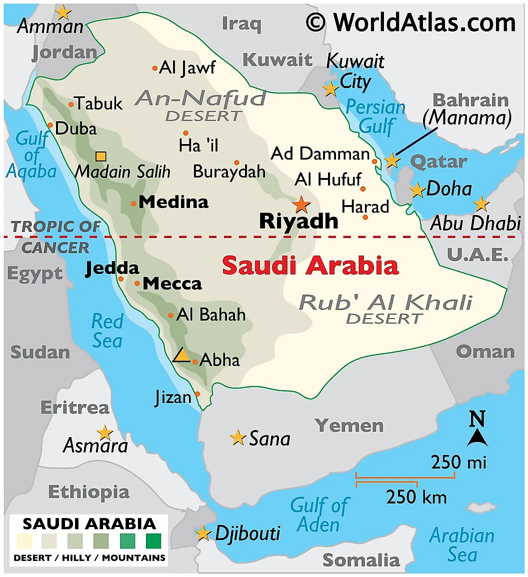
Saudi Arabia is the fifth largest country in Asia, covering 2,149,690 square km (830,000 square miles) and occupying most of the Arabian Peninsula. The capital is Riyadh. The country's population is approximately 36 million. Saudi Arabia has coastlines on both the Red Sea (west) and the Persian Gulf (east), with the bulk of its territory dominated by desert: the Rub' al Khali (Empty Quarter) in the southeast is the world's largest sand desert, and the An-Nafud sits to the north. The country holds the world's second largest proven conventional oil reserves and is one of the world's largest crude oil exporters, though the United States now outranks Saudi Arabia in total petroleum production. The Asir Mountains in the southwest are home to Jabal Sawda, the country's highest point at about 3,133 meters.
6. Iran
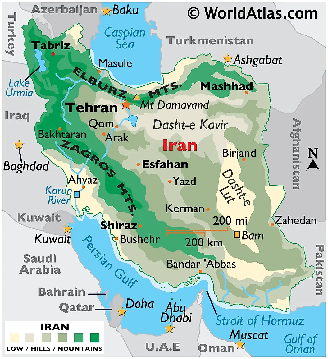
Iran covers 1,648,195 square km (636,372 square miles), making it the sixth largest country in Asia and the second largest country in the Middle East after Saudi Arabia. The capital is Tehran. Iran's population is approximately 89 million. The country has coastlines on the Persian Gulf, the Gulf of Oman, and the Caspian Sea, with mountain ranges (the Zagros and Alborz) framing the interior Iranian Plateau. Iran has 28 UNESCO World Heritage Sites, one of the highest counts in Asia, reflecting a continuous history of settlement and statehood that spans the Elamite civilization, the Achaemenid Persian Empire, and the various dynasties of the Islamic period through the present day.
7. Mongolia
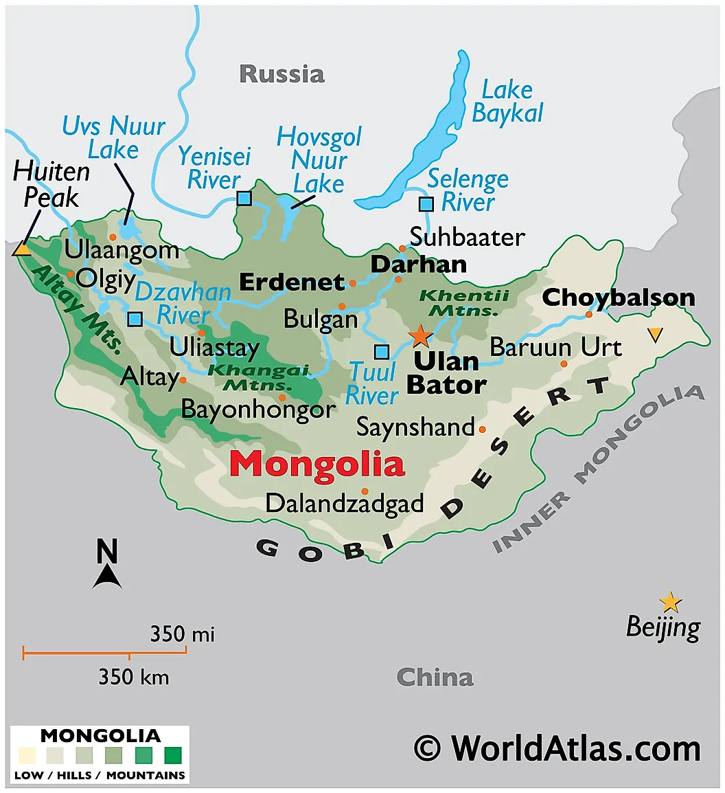
Mongolia is located between Russia and China, covering 1,564,116 square km (603,909 square miles) and making it the seventh largest country in Asia. The capital is Ulaanbaatar. The population is approximately 3.5 million, one of the lowest population densities of any country in the world at about 2 people per square km. Mongolia is the second largest landlocked country in the world (after Kazakhstan). The country sits on the Mongolian Plateau, with the Gobi Desert occupying the southern part of the country, mountain ranges to the north and west, and large grassland steppe regions in between.
8. Indonesia
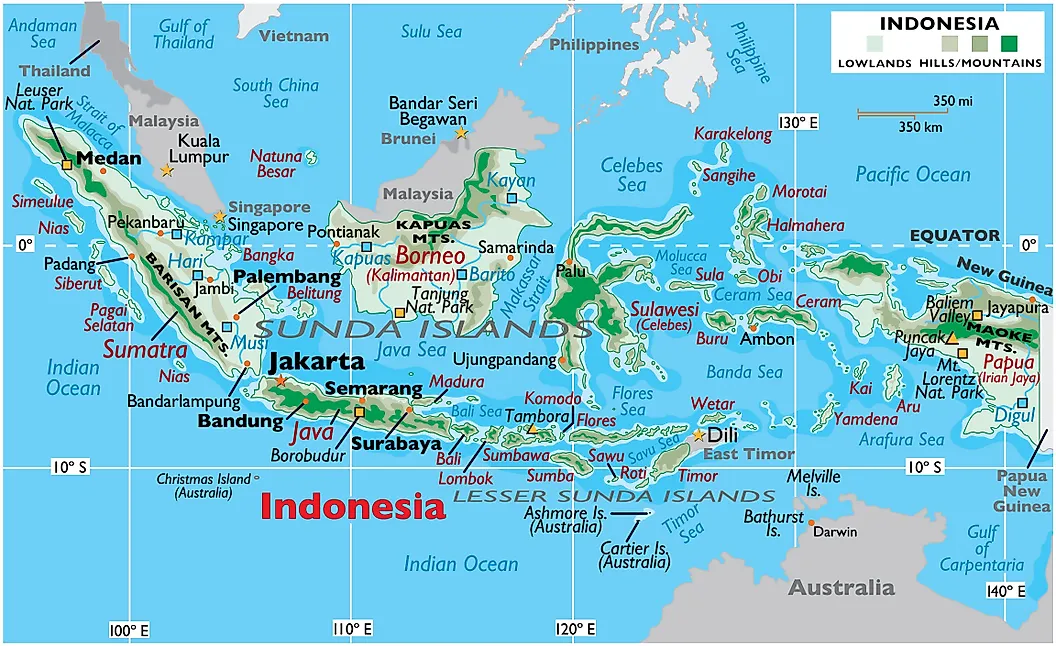
Indonesia is an archipelago of more than 17,500 islands located between the Pacific and Indian Oceans, with a total area of 1,904,569 square km (735,358 square miles). About 1,472,639 square km of that area sits within the Asian portion of the country, with the remainder in Oceania (mainly the Indonesian half of New Guinea). The capital is Jakarta, located on the island of Java. Indonesia's population is approximately 283 million, making it the world's fourth most populous country after India, China, and the United States. The three largest Indonesian islands by area are Sumatra, Indonesian Borneo (the Kalimantan portion), and Indonesian New Guinea (the Papua portion). Java, the most populous island, contains more than half the country's population. Indonesia is the world's largest producer of palm oil and a significant producer of rubber, coffee, and tin.
9. Pakistan
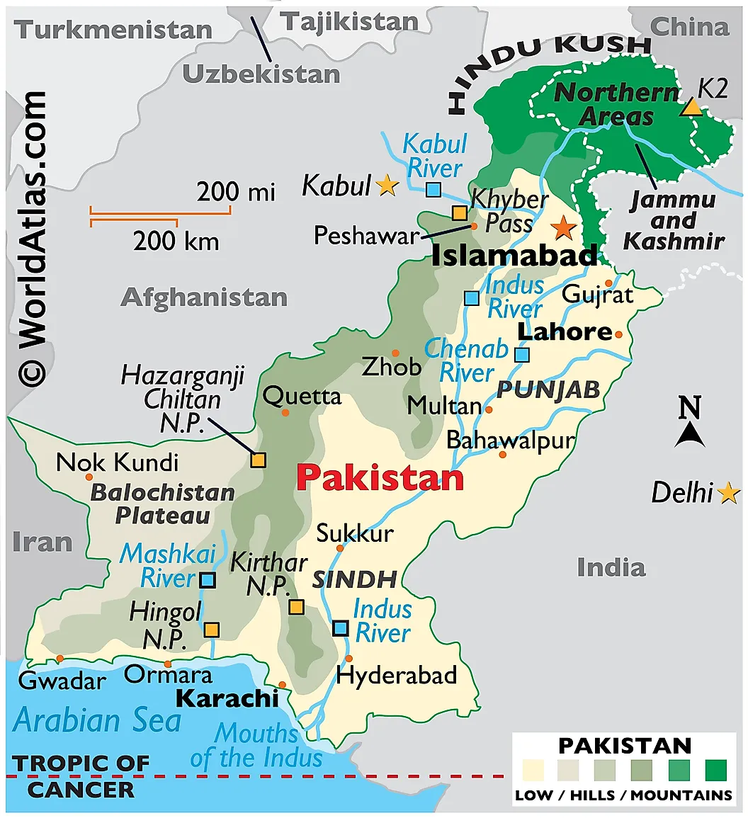
Pakistan is located in South Asia, northwest of India, with a total area of 881,913 square km (340,509 square miles) including Pakistani-administered Kashmir (the figure is 796,095 square km without the disputed regions). The capital is Islamabad. Pakistan's population is approximately 251 million, making it the fifth most populous country in the world. The country shares land borders with Iran, Afghanistan, China, and India, and has a coastline on the Arabian Sea. Pakistan is home to five mountain peaks over 8,000 meters (including K2, the world's second-highest peak at 8,611 meters), all sitting in the Karakoram or Himalayan ranges in the north. The Indus River runs the length of the country and supports most of its agriculture.
10. Turkey
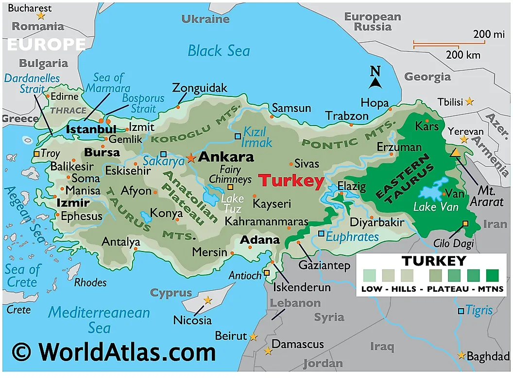
Turkey covers a total area of 783,562 square km (302,535 square miles), of which 747,272 square km sits on the Anatolian Peninsula in Asia and the remainder (the Eastern Thrace region) sits in Europe, making Turkey a transcontinental country. The capital is Ankara. The population is approximately 86 million. Turkey is bordered by the Black Sea to the north, the Aegean Sea to the west, and the Mediterranean Sea to the south, with the Sea of Marmara and the Bosphorus and Dardanelles straits separating the Asian and European portions. The country's terrain includes coastal plains, the Anatolian Plateau, and significant mountain ranges including the Pontic Mountains in the north and the Taurus Mountains in the south.
What The Ten Largest Have In Common
The ten largest countries in Asia cover an enormous combined area but tell ten very different geographic stories. Russia, Kazakhstan, and Mongolia together account for most of the continental interior, including the bulk of the steppe and taiga belts. China and India anchor the eastern and southern portions and between them hold roughly 35% of all humans alive today. Saudi Arabia and Iran occupy most of the Middle East's land area and a significant share of the world's known oil reserves. Indonesia and Pakistan are both demographic giants (each over 250 million people) with very different physical geographies (an archipelago straddling two oceans, and a single mountainous corridor along the Indus). Turkey straddles two continents at the hinge between Europe and Asia. The remaining 38 Asian countries are listed below.
List of Asian Countries and Capitals By Land Area
| Rank | Country | Capital | Area (km²) |
|---|---|---|---|
| 1 | Russia | Moscow | 13,100,000 (17,098,246 including European part) |
| 2 | China | Beijing | 9,596,961 (excludes Hong Kong, Macau, Taiwan and disputed areas/islands) |
| 3 | India | New Delhi | 3,287,263 |
| 4 | Kazakhstan | Astana | 2,455,034 (2,724,900 km² including European part) |
| 5 | Saudi Arabia | Riyadh | 2,149,690 |
| 6 | Iran | Tehran | 1,648,195 |
| 7 | Mongolia | Ulaanbaatar | 1,564,116 |
| 8 | Indonesia | Jakarta | 1,472,639 (1,904,569 km² including Oceanian part) |
| 9 | Pakistan | Islamabad | 881,913 (796,095 km² excluding Pakistani-administered Kashmir) |
| 10 | Turkey | Ankara | 747,272 (783,562 km² including European part) |
| 11 | Myanmar | Naypyidaw | 676,578 |
| 12 | Afghanistan | Kabul | 652,230 |
| 13 | Yemen | Sana'a | 527,968 |
| 14 | Thailand | Bangkok | 513,120 |
| 15 | Turkmenistan | Ashgabat | 488,100 |
| 16 | Uzbekistan | Tashkent | 447,400 |
| 17 | Iraq | Baghdad | 438,317 |
| 18 | Japan | Tokyo | 377,930 |
| 19 | Vietnam | Hanoi | 331,212 |
| 20 | Malaysia | Kuala Lumpur | 330,803 |
| 21 | Oman | Muscat | 309,500 |
| 22 | Philippines | Manila | 300,000 |
| 23 | Laos | Vientiane | 236,800 |
| 24 | Kyrgyzstan | Bishkek | 199,951 |
| 25 | Syria | Damascus | 185,180 |
| 26 | Cambodia | Phnom Penh | 181,035 |
| 27 | Bangladesh | Dhaka | 147,570 |
| 28 | Nepal | Kathmandu | 147,181 |
| 29 | Tajikistan | Dushanbe | 143,100 |
| 30 | North Korea | Pyongyang | 120,538 |
| 31 | South Korea | Seoul | 100,210 |
| 32 | Jordan | Amman | 89,342 |
| 33 | Azerbaijan | Baku | 86,600 |
| 34 | United Arab Emirates | Abu Dhabi | 83,600 |
| 35 | Georgia | Tbilisi | 69,700 |
| 36 | Sri Lanka | Sri Jayawardenepura Kotte | 65,610 |
| 37 | Bhutan | Thimphu | 38,394 |
| 38 | Armenia | Yerevan | 29,743 |
| 39 | Israel | Jerusalem | 20,770 |
| 40 | Kuwait | Kuwait City | 17,818 |
| 41 | Timor-Leste | Dili | 14,874 |
| 42 | Qatar | Doha | 11,586 |
| 43 | Lebanon | Beirut | 10,452 |
| 44 | Cyprus | Nicosia | 9,251 |
| 45 | Brunei | Bandar Seri Begawan | 5,765 |
| 46 | Bahrain | Manama | 765 |
| 47 | Singapore | Singapore | 728 |
| 48 | Maldives | Male | 300 |


