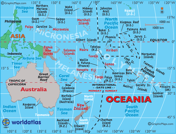
Home
Continents
Oceania
Oceania Maps
Oceanian Symbols
Location of Oceania
Oceania Geography
Oceanian Flag
Oceania Facts
Oceania
Geography Statistics of Oceania
Oceania Maps:
Australia Landforms
Large Color Map
Name the Countries
Outline Map
Time Zone Map
Country Maps:
Australia
Fiji
Kiribati
Marshall Islands
Micronesia
Nauru
New Zealand
Palau
Papua New Guinea
Samoa
Solomon Islands
Tonga
Tuvalu
Vanuatu
Note:
All recognized countries of Oceania are shown in
red
on the map.
Latest by WorldAtlas
The 8 Best Places to Retire on the Atlantic Coast
How Many Invasive Species Live In The Great Lakes?
7 Best Natural Wonders To Visit In Alabama This Year
5 Snake Hotspots In The Southern United States
7 Secluded Towns in Georgia
9 Stunning Small Towns In Wisconsin
7 Most Rattlesnake Infested Areas in New England
8 Overlooked Towns In The Northern United States Worth Visiting
New York's 9 Best Retirement Towns Ranked
9 Slow-Paced Towns to Visit in New Jersey
8 Best Places To Live In Vermont In 2026
7 Best Downtowns In Rhode Island
Continents
All Continents
North America
Caribbean
Central America
South America
Europe
Africa
Middle East
Asia
Oceania
Arctic
Antarctica
Countries
All Countries
US Maps
China Maps
Russia Maps
Philippines Maps
Egypt Maps
Geography
Bodies of Water
Landforms
Places
Nature
All Geography
Education
History
Science
Social Science
Society
Economics
Politics
About Us
Contact Us
Privacy
Copyright
Search WorldAtlas