Maps of Solomon Islands

The Solomon Islands borders the Solomon and Coral Seas to the south, the Pacific Ocean to the north and east, and shares maritime borders with Papua New Guinea to the west and with Vanuatu to the southeast. The country occupies a land area of 28,466 km2 (10,938 mi2) and consists of nearly 1,000 islands (6 large main islands and over 900 smaller islands), divided broadly into nine provinces across 249,000 square nautical miles. The Solomon Islands feature a wide range of geographical formations, including volcanic islands, coral atolls, and rugged mountainous terrains.
The Guadalcanal Province, home to the country's capital, Honiara, contains the island of Guadalcanal. This island is characterized by a mountainous interior, with Mount Popomanaseu reaching an elevation of 7,644 feet (2,330 meters), the highest in the country. Guadalcanal holds significance for its historical role in World War II, but from a geographical standpoint, the island is also known for its rich soil and fast-flowing rivers like the Matanikau and Lunga rivers.
The Western Pronvince contrasts by consisting mainly of coral atolls and smaller volcanic islands. This province includes famous destinations like the New Georgia Islands, known for their intricate channels and lagoons. The area has a lower elevation compared to Guadalcanal and is largely covered by dense forests and mangroves. The Roviana Lagoon, one of the largest saltwater lagoons in the Solomon Islands, provides vital breeding grounds for fish and other marine species.
Malaita Province comprises mainly the large island of Malaita, which features a rugged interior with steep mountains. The island has various rivers, including the Kwai and To'abaita rivers, which drain into the Pacific Ocean. Malaita’s geography contributes to its cultural significance, as the island remains one of the most culturally intact regions in the Solomon Islands.
Makira Province, encompassing the island of Makira, presents a topography of rolling hills and low-lying areas. The island harbors important rivers like the Bauro and Warihito, which have nurtured agricultural practices, particularly the cultivation of root crops and cocoa.
The Province of Choiseul occupies the island of the same name and is marked by its dense rainforests and winding rivers like the Zinoa and Pabusu. The island also boasts the highest peak in the province, Mount Maetambe, standing at an elevation of 3,773 feet (1,150 meters).
Isabel Province, containing the island of Isabel, is less mountainous than some of its counterparts but is noteworthy for its narrow shape and the Marovo Lagoon, one of the largest double barrier-reef enclosed lagoons in the world. The lagoon sustains a wide range of marine biodiversity and serves as a critical ecosystem for the region.
Central, Rennell and Bellona, and Temotu—the remaing provinces—include smaller islands and atolls, each with its unique geographical features. Central Province mainly comprises Florida and Russell Islands, both of which are volcanic in origin. Rennell and Bellona feature raised coral atolls, while Temotu includes the remote Santa Cruz Islands, which have both volcanic and coral atoll formations.
The Solomon Islands was affected by nuclear testing, specifically the UK’s Operation Grapple that occurred near Christmas Island (now Kiritimati, part of Kiribati), a few thousand kilometers from the Solomon Islands. Although the Solomon Islands were not the site of nuclear tests, the region faced the indirect impacts of these activities, including concerns about radioactive fallout and environmental degradation in the broader Pacific area.
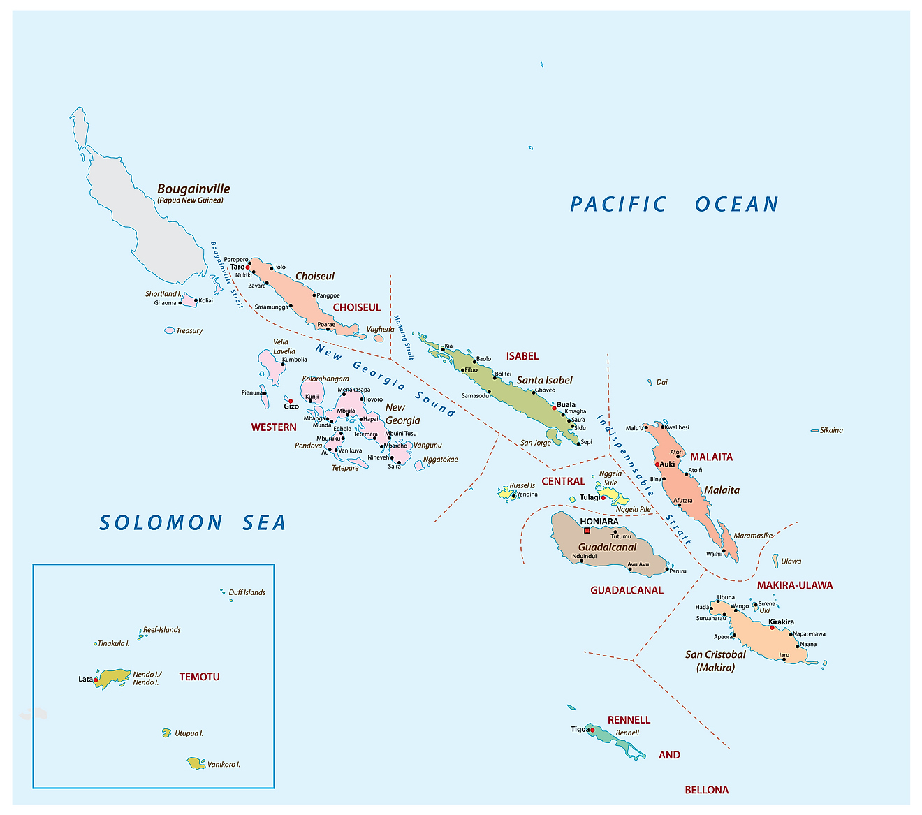
Solomon Islands is divided into 9 provinces and 1 capital city – Honiara. In alphabetical order, the 9 provinces are: Central, Choiseul, Guadalcanal, Isabel, Makira and Ulawa, Malaita, Renneu and Bellona, Temotu and Western.
Covering an area of 28,400 sq.km, Solomon Islands consists of 6 principal islands and approximately 1000 smaller islands. Located on the northwestern coast of Guadalcanal is, Honiara – the capital and the largest city of Solomon Islands.
Where is Solomon Islands?

Solomon Islands are an archipelagic state comprising of a double chain of 992 volcanic islands and coral atolls in Melanesia, located in southwest Pacific Ocean. It is geographically positioned in the Southern and Eastern hemispheres of the Earth. Solomon Islands is situated to the southeast of Papua New Guinea and to the northwest of Vanuatu.
Regional Maps: Map of
Outline Map of Solomon Islands

The above blank map represents Solomon Islands - an archipelagic state comprising of a double chain of 992 volcanic islands and coral atolls in Melanesia, located in southwest Pacific Ocean. The above map can be downloaded, printed and used for geography education purposes like map-pointing and coloring activities.

The above outline map represents Solomon Islands - an archipelagic state comprising of a double chain of 992 volcanic islands and coral atolls in Melanesia, located in southwest Pacific Ocean.
Key Facts
| Legal Name | Solomon Islands |
|---|---|
| Flag |
|
| Capital City | Honiara |
| 9 26 S, 159 57 E | |
| Total Area | 28,896.00 km2 |
| Land Area | 27,986.00 km2 |
| Water Area | 910.00 km2 |
| Population | 669,823 |
| Currency | Solomon Islands dollars (SBD) |
| GDP | $1.43 Billion |
| GDP Per Capita | $2,127.54 |
This page was last updated on September 14, 2023