The Best State Parks In The Deep South
The Deep South is host to some of the most varied state park landscapes in the United States, spanning Gulf Coast wetlands, spring-fed rivers, arid canyonlands, mountain ridges, towering waterfalls, ancient forests, and more. Desert-like locales such as Palo Duro Canyon are present, while wooded preserves like Amicalola Falls and Tishomingo also sit not too far away within the same proximity. Several of these parks, if not all, also protect important wildlife habitat, historic sites, and recreational waterways. With that, this list highlights six Southern state parks where the most distinctive geology, a number of major natural/manmade features, and well-developed trail systems make for particularly strong additions to any trip across the area.
Cheaha State Park, Alabama

Cheaha State Park sits atop Cheaha Mountain, the highest point in Alabama at a little over 2,405 ft (733 m). This makes it a perfect starting point for exploring this Southern state's surprisingly diverse terrain. The park occupies part of the Talladega Mountains and provides access to the Cheaha Wilderness Trail, while shorter routes lead to overlooks across the nearby ridges and valleys. Notable expanses of rock outcrops and exposed slopes further distinguish the landscape from the flatter terrain found across much of Alabama and its surrounding states.
Cheaha is also connected to the Pinhoti Trail, a long-distance route extending more than 335 miles through both Alabama and Georgia. But for a more relaxed outing, Cheaha Lake provides a pleasant, designated swimming area and fishing hole, while the summit area, easily reachable by car, includes a stone observation tower that'll give you expansive views high above the region, an area that is especially beautiful in the fall season.
Its location along Alabama Highway 281 allows the park to be an extra convenient stop for travelers exploring the broader Talladega Mountains and Talladega National Forest, making Cheaha a great choice on any Deep South road trip.
Palo Duro Canyon State Park, Texas

Palo Duro Canyon State Park encompasses the southern section of Palo Duro Canyon in northern Texas. It is actually the second-largest canyon system in the United States, sitting only behind the Grand Canyon further west.
This sizable gorge reaches depths of about 800 ft (244 m), with wonderfully colorful layers of sandstone, shale, and gypsum exposed along its walls. It is a perfect place for a landscape photo or two during sunset or sunrise. Local geology records millions of years of erosion and sediment deposition, while the open-air rock layers reveal a detailed cross-section of the Texas Panhandle's natural history. Palo Duro Canyon has an equally interesting history of human use, too, including evidence of Indigenous peoples going back thousands of years and later ranching operations as the Spanish, then Americans, populated the area.
As a whole, the park contains close to 30,000 acres of pristine habitats and has over 30 miles of hiking, biking, and equestrian trails for you to get around on at a slower pace. The Lighthouse Trail is perhaps the park's best-known hike, covering 5.8 miles (9.3 km) round trip to the "Lighthouse," a distinctive 310-ft (94-m) rock formation. Other routes descend into the canyon or follow its rims, providing views of landmarks such as Capitol Peak and Fortress Cliff.
Blue Spring State Park, Florida

Lying along the St. Johns River near Orlando, Blue Spring State Park centers on a natural spring that discharges more than 100 million gal (378 million L) of water per day. The water also remains about 72°F (22°C) year-round, creating important winter habitat for West Indian manatees.
During the colder months, hundreds of these manatees can gather in the spring run, with the park closed to swimming and other water activities during this season. But outside that period, you can swim, snorkel, canoe, kayak, and tube in the designated areas for a truly up-close experience in this amazing environment.
Moreover, there is more than 2,600 acres of hardwood forest, scrub, and wetland habitat here as well, with trails running through the surrounding landscape. The 4.5-mi (7.2-km) Pine Island Trail is a good recommendation to stroll along, as it extends through several different habitats and provides plentiful opportunities to see wading birds, turtles, and other wildlife. Furthermore, the spring has historically been used as a source of drinking water for nearby communities, making its preservation all the more important.
Fontainebleau State Park, Louisiana

Fontainebleau State Park occupies a quiet 2,800 acres along Lake Pontchartrain's north shore, where stands of live oaks, marshes, and sandy shoreline add up to form one of Louisiana's most accessible, yet nice, pieces of green space. Its location on this renowned body of water provides a direct link for visitors and nearby residents alike to one of the largest estuaries in the United States.
Just a short drive from New Orleans, this park sits on the site of a former sugar mill established in 1829, with remnants of the mill's brick foundations still remaining visible near the shoreline. A web of nature trails now follows parts of the park's wetlands and forests, while longer routes connect to the Tammany Trace, a 31-mi (50-km) rail-trail extending across St. Tammany Parish. Wherever you decide to go, look around to see Fontainebleau's selection of remarkably large live oaks, many draped with Spanish moss, along with palmettos and other plants adapted to the Gulf Coast climate.
On the other hand, the lakefront includes a public-use beach, with swimming permitted when conditions allow. The waters here provide convenient access for fishing and boating, too. Fontainebleau State Park is also part of the Great Louisiana Bird Fest area, with huge flocks of migratory and resident birds using its wetlands and shoreline year over year.
Amicalola Falls State Park, Georgia

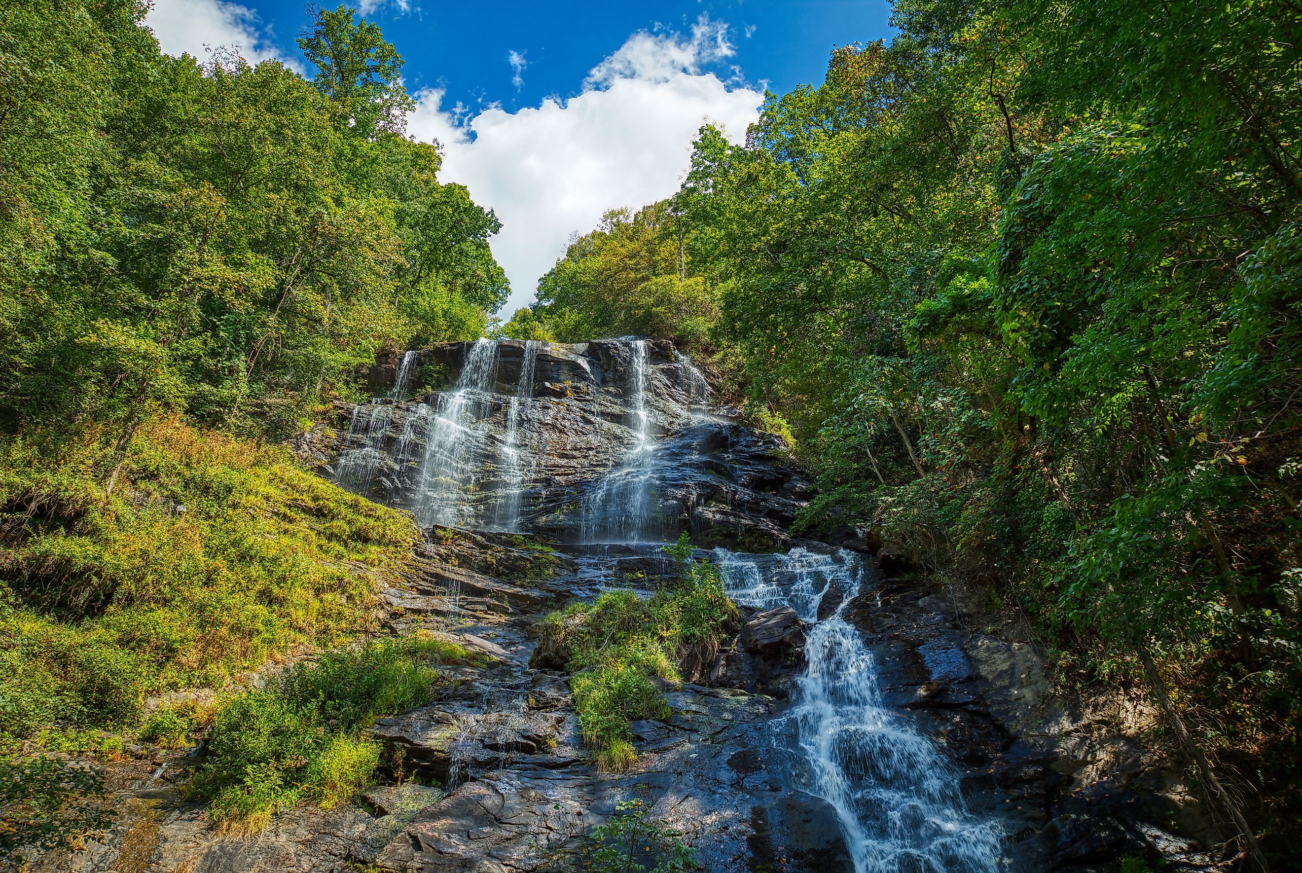
Amicalola Falls State Park presides over Amicalola Falls, the highest waterfall in Georgia, with a total drop of 729 ft (222 m). These impressive falls descend through a scenic series of cascades in the southern Blue Ridge Mountains, and several trails provide access to different sections. To add to this already attractive landscape, Amicalola's elevation ranges from roughly 1,600 to 3,000 ft (488 to 914 m), creating cooler, often more comfortable conditions for outdoor activity than much of the Deep South commonly sees.
The Amicalola Falls Loop includes a thigh-burning 425 stairs alongside the falls, while the lengthier but somewhat flatter Approach Trail connects the park to Springer Mountain, the southern terminus of the Appalachian Trail. There are 829 acres in total open for exploration too, containing a plethora of verdant hardwood forests, mountainous waterways, and steep slopes typical of the region.
A local lodge and campground provide overnight accommodations, while the visitor center better explains the geology and natural history of the falls and surrounding mountain ranges.
Tishomingo State Park, Mississippi

Tishomingo State Park boasts more than 1,500 acres of wilderness in northern Mississippi. It is where the foothills of the Appalachian Mountains reach into the state along the eastern edge of the Mississippi Hills. Named for Chief Tishomingo, a famed Chickasaw leader, this park's rugged terrain currently draws crowds of visitors to its large sandstone outcrops, canyons, lively ravines, boulder fields, and fern-filled hollows uncommon elsewhere in the state.
Tishomingo State Park, as it stands today, was developed by the Civilian Conservation Corps during the mid-to-late 1930s, with several original stone structures still standing. On the nature side of things, several rock formations throughout the area, as well as the scenic Bear Creek Canyon, contain evidence of ancient plant fossils, reflecting the region's much longer geological history.
Walking the CCC Spur Trail is an excellent way to get a feel for the land, as it winds throughout much of the parkland and connects several of its major landmarks, while the shorter Swinging Bridge Trail crosses Bear Creek on a historic swinging bridge. Canoeing and kayaking are available on Bear Creek, too, and the small Haynes Lake offers additional opportunities for fishing and boating.
Note that Tishomingo also connects to the Natchez Trace Parkway, making it a useful stop for all sorts of travelers, whether outdoorsmen or casual sightseers, exploring northeastern Mississippi.
Explore the Wonders of the South in These State Parks
These destinations boast a surprisingly broad range of terrain, spanning the sandstone formations of Tishomingo State Park, the Gulf Coast delights of Fontainebleau, the scrublands of Palo Duro Canyon, and the waterfalls of Amicalola Falls. But wherever you head off to this year, each one is sure to provide access to top-tier hiking routes, fascinating historical sites, clean rivers, healthy forests, thriving wildlife habitat, and all-around distinctive geographical features across this storied region of America.