8 Best Natural Wonders To Visit In The Great Lakes This Year
The Great Lakes are far more than just five of the largest bodies of freshwater on the planet. Their shores contain countless other natural wonders, such as towering sand dunes, sea caves, and other cool geological formations. Niagara Falls drops along the lengthy Niagara Escarpment, Pictured Rocks exposes colorful stones along Lake Superior, and Manitoulin Island contains some of the region's most unusually record-breaking hydrology, just to name a few.These landmarks span from Ontario to Michigan, Wisconsin and Indiana, across to New York, and beyond. Better yet, each site is open for you to visit year-round either by car, boat, or foot.
Niagara Falls

Niagara Falls is perhaps the Great Lakes' most dramatic natural spectacle, where the Niagara River plunges over three enormous waterfalls along the border of Ontario and New York. It was formed about 12,000 years ago when retreating glaciers exposed the Niagara Escarpment, surging meltwater through the Great Lakes basin toward Lake Ontario.
Today, the river drops about 326 feet (99 m) from Lake Erie to Lake Ontario over the escarpment at three waterfalls: Horseshoe Falls, American Falls, and Bridal Veil Falls. Horseshoe Falls straddles the international border and accounts for roughly 90% of the river's flow over the falls. The falls themselves drop about 187 feet (57 m) at their highest point, which you can witness at several nearby overlooks in and around an adjacent state park.
Erosion continues to shape the gorge at a relatively fast rate, particularly around Horseshoe Falls closer to the Canadian border, where the quick-moving water constantly cuts into the underlying rock. The surrounding Niagara Gorge also exposes layers of shale, limestone, and sandstone deposited hundreds of millions of years ago, making it a top spot for geology buffs and sightseers alike.
Pictured Rocks

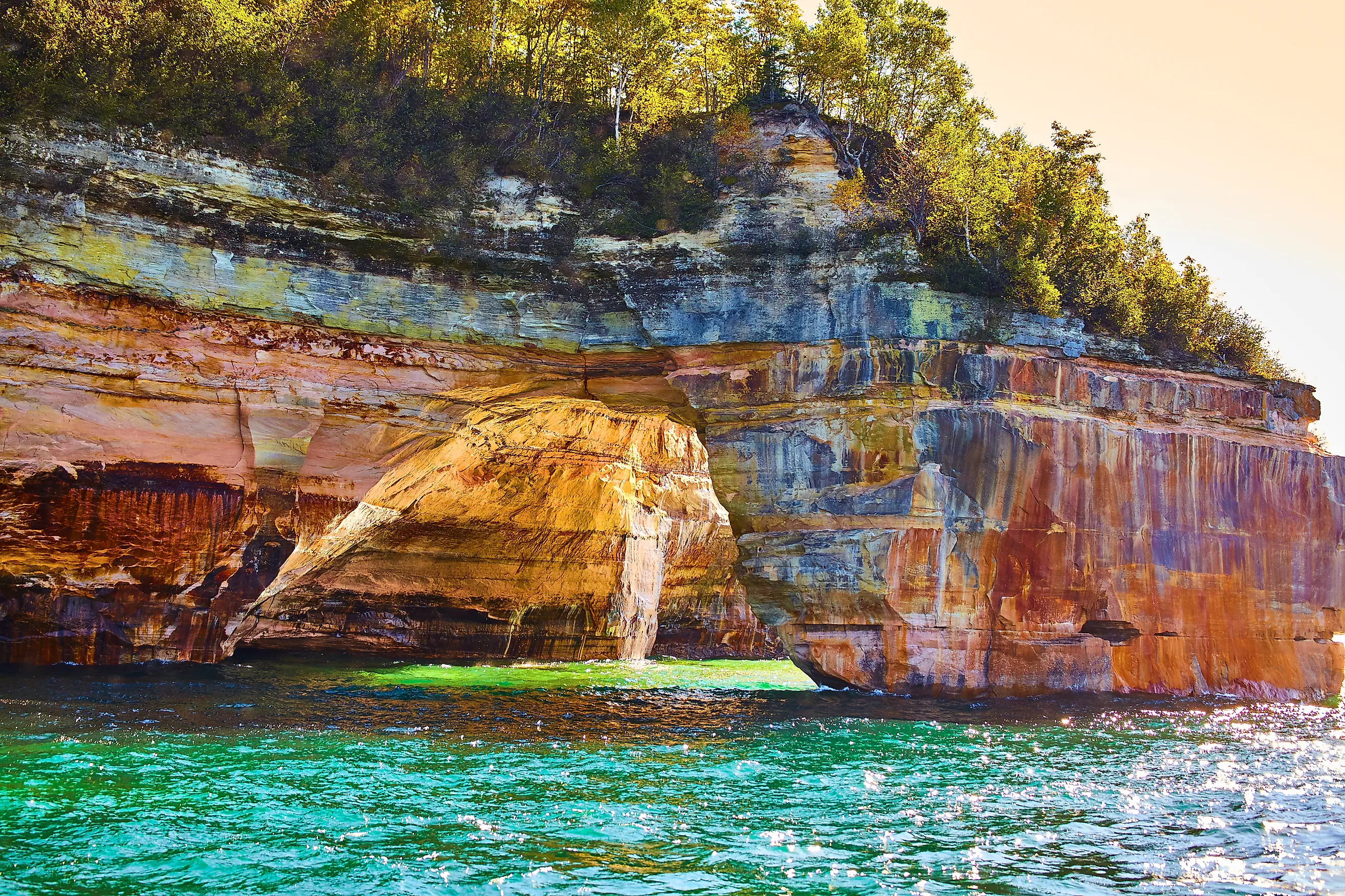
Pictured Rocks National Lakeshore stretches for about 42 miles (68 km) along Lake Superior's southern shore in Michigan, where sandstone cliffs rise as high as 200 feet (61 m) above the lake. Its iconic cliffs get their eye-catching colors from mineral stains, as iron produces red and orange, copper creates blue and green, and manganese contributes darker tones.
Waves and freeze-thaw weathering have carved features into this unique shoreline, like sea arches, sea caves, stacks, and narrow channels. Chapel Beach, Chapel Falls, and Miners Castle are among the most notable sites, while Chapel Rock has a precariously white pine growing from its sandstone ledge that is perfect for a memorable photo.
Kayaking provides the closest views of formations such as Lovers Leap and Rainbow Cave, although conditions on Lake Superior can change quickly and guides are recommended for the inexperienced. Inland, on the other hand, boasts more than 100 miles (161 km) of trails that cross pristine forests, wetlands, waterfalls, and beaches, making Pictured Rocks an all-around recreational destination as much as a scenic one.
Sleeping Bear Dunes

Sleeping Bear Dunes National Lakeshore occupies about 35 miles (56 km) of Lake Michigan's shoreline, where wind has piled glacial sand into dunes rising more than 450 feet (137 m) above the water.
The most spectacular section is the Dune Climb, while the Pierce Stocking Scenic Drive provides elevated but convenient views over the dunes and Lake Michigan beyond. Offshore, the visible Manitou Islands continue the same glacial story, with North Manitou Island containing yet more extensive dunes, forests, and inland lakes for you to see.
This protected lakeshore also features "perched dunes," a rare type of formation created when sand accumulates high on bluffs rather than directly along the shoreline. At the Sleeping Bear Point Maritime Museum, you can learn more about this and also see how the area's often dangerous offshore shoals once greatly affected the history of shipping on the Great Lakes.
Apostle Islands

The Apostle Islands National Lakeshore protects 21 islands in Lake Superior, along with 69,372 acres of mainland and lake waters. Its sandstone shoreline was carved by the unrelenting powers of waves, ice, and weathering, creating an array of sea caves, arches, cliffs, and tight passages. The islands also contain boreal forest, wetlands, and beaches, with Lake Superior strongly shaping their climate and geology as well.
The mainland sea caves near Meyers Beach are among the park's most distinctive formations, while Devils Island has some of the largest and most intricate caves in the archipelago. Moreover, eight historic light towers stand across six of the islands, including the Raspberry Island Light, built in 1862.
In winter, sufficiently cold conditions can actually freeze the water in and around the lake caves, creating ice formations that have occasionally allowed visitors to enter them on foot. For the more daring, this is a popular spot for ice climbers too on various frozen-over cliff faces.
Isle Royale

Isle Royale National Park is a remote island wilderness in Lake Superior near the coast of northern Minnesota, stretching 45 mi (72 km) long and only about 9 mi (14 km) wide at its broadest point. The island is the exposed crest of a volcanic and sedimentary rock formation, with ancient lava flows creating the ridges that run across its interior. The surrounding archipelago contains more than 450 smaller islands and rocky outcrops, while inland terrain includes dense boreal forests, wetlands, and, impressively, more than 160 mi (257 km) of hiking trails.
Rock Harbor and Windigo are the park's two main visitor areas, with Rock Harbor providing views across Lake Superior toward numerous offshore islands. You may also know Isle Royale for its long-running wolf and moose study, begun in 1958, making the island an important site for observing how predators and prey can mould an isolated ecosystem.
Bruce Peninsula

Bruce Peninsula National Park occupies nothing other than the northern tip of Ontario's Bruce Peninsula, where the Niagara Escarpment meets Georgian Bay. The area's most distinctive geology can be seen exposed along its extensive shoreline, where erosion has sculpted limestone into anything from caves and arches to lofty cliff ledges.
The Grotto is the best-known formation here, encompassing a partially submerged cave with a large opening onto Georgian Bay, reached by trails through the park's rocky terrain. You can also swim into the cave, although beware the water is generally quite cold. Moving on, the nearby Indian Head Cove contains weathered limestone shelves on which you can rest, and more swathes of beautifully clear blue-green water just beyond. The same escarpment also continues through the Bruce Peninsula and forms the backbone of the Bruce Trail, Canada's oldest and longest marked footpath.
Next, Fathom Five National Marine Park lies immediately offshore, protecting 22 shipwrecks and numerous small islands. Together, the two parks reveal the region's must-see combination of cool geology, freshwater coastal ecology, and a longstanding human history dating back to pre-colonial times.
Manitoulin Island

Manitoulin Island rests in Lake Huron and is the world's largest freshwater island, covering about 1,068 mi² (2,766 km²). Geographically, it is yet another Great Lakes locale connected to the Niagara Escarpment, which curves across the island and creates prominent cliffs, ridges, and rocky outcrops.
At its western end, Bridal Veil Falls is a popular stop, as it drops about 36 feet (11 m) into a picturesque limestone gorge near Kagawong. The island also contains more than 100 inland lakes of its own, including Lake Manitou, the largest lake on an island within a lake. Furthermore, Misery Bay Provincial Park protects a surprisingly nice section of the island's southern shoreline, where alvars (thin-soil ecosystems growing directly on exposed limestone) support a plethora of native plants adapted to harsh conditions.
Overall, the Cup and Saucer Trail provides probably the best views of Manitou from the escarpment's cliffs, with the highest point rising roughly 230 feet (70 m) above Lake Huron.
The Indiana Dunes

Indiana has a small but very scenic slice of the Great Lakes. The Indiana Dunes National Park presides over 15 miles (24 km) of Lake Michigan's southernmost shoreline, where shifting sand has created a series of dunes, swales, wetlands, and beaches just minutes outside of Chicago.
Mount Baldy is the largest active dune here, jutting about 126 feet (38 m) up. The park is also notable for its unusual plant diversity, with more than 1,100 native plant species having been recorded here, reflecting the close proximity of prairie, oak savanna, and wetland habitats within it. At Cowles Bog, groundwater-fed wetlands occupy depressions between ancient beach ridges, too, adding more variety for nature lovers to appreciate in this often overlooked location.
And for history fans, the nearby 19th-century Bailly Homestead and Chellberg Farm rest within the area's inland forests, a space that contrasts sharply with the open dune landscape but is particularly beautiful in autumn when the hardwood foliage changes color.
Experience the Wonders of the Great Lakes for Yourself Today
It should now be clear that the Great Lakes contain a remarkable range of features worth venturing out to spring, summer, fall, and winter, from massive waterfalls and cliffs to lakeside caves, imposing dunes, and island landscapes. These places reflect thousands, or even millions, of years of glacial activity, erosion, and changing water levels, telling a tale of why this region is so important today. Visiting them will surely provide a closer look at the forces that created the Earth's greatest chain of freshwater lakes and continue to reshape their shores, landmarks, and settlements now and into the future.