The 9 Most Underrated State Parks You Should Visit
Most people drive past a state park on their way to a national park. That is the whole problem, and also the opportunity. The nine parks below hold their own against the famous names next door, and on most days you will share them with a fraction of the crowd. A few of them protect things the big parks cannot match: the headwaters of the Mississippi, the largest protected expanse in the eastern United States, a waterfall left over from one of the largest floods in Earth's history. Here is where to find them.
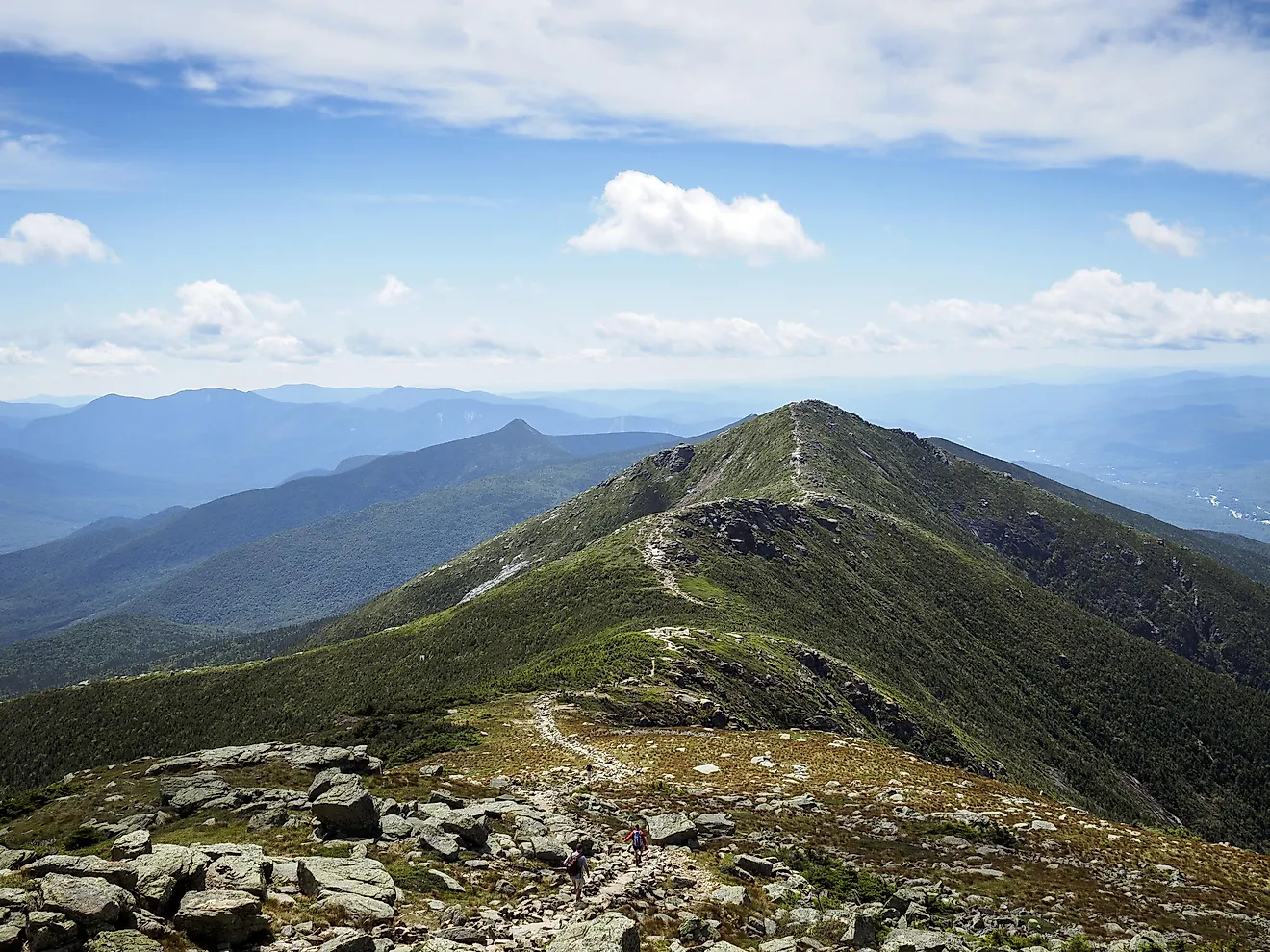
Adirondack Park, New York

Adirondack Park covers about six million acres, which makes it larger than Yellowstone, Everglades, Glacier, and Grand Canyon National Parks combined, and the largest publicly protected area in the contiguous United States. New York created it in 1892, and roughly half of it is private land, with towns and farms scattered among the forest. It is the largest stretch of wilderness east of the Mississippi, and it has collected its share of tall tales: the early Dutch reportedly believed unicorns roamed these woods.
If you only have a day, take Route 73, the High Peaks Scenic Byway, which runs through Keene Valley toward Lake Placid. Stop along Loj Road for a look at the High Peaks, then continue into Lake Placid, which hosted the Winter Olympics in 1932 and 1980, and take in Whiteface Mountain. Big Slide Brewery and Public House makes a good lunch stop before you head back out.
Custer State Park, South Dakota

Custer State Park sits about 20 miles south of Rapid City, spread across 71,000 acres of prairie and rugged Black Hills mountains. It is South Dakota's first and largest state park, established in 1919, and it holds one of the largest publicly owned, free-roaming bison herds in the world, somewhere around 1,300 to 1,500 animals. Each fall the park rounds them up to manage the herd, an event worth timing a visit around if you can.
Bison are not the only residents. Look for elk, pronghorn, coyotes, and the park's well-known begging burros, which will walk right up to your car. Five lakes dot Custer State Park, including Sylvan Lake below the granite spires, and the Needles Highway threads through narrow tunnels and rock formations on its way past them. Black Elk Peak, the highest point east of the Rockies, rises within reach of the trails.
Palouse Falls State Park, Washington

Palouse Falls drops nearly 200 feet through a canyon in southeastern Washington, where it was named the official state waterfall in 2014. The falls run year-round, which is rarer than it sounds out here, and the surrounding rock is as much of a draw as the water: a deep, banded gorge far too big for the modest river flowing through it today.
That mismatch is the clue to its origin. The canyon was carved by the Ice Age Missoula floods, one of the largest floods known to geology. When a lobe of the Cordilleran ice sheet dammed Montana's Clark Fork River, the water backed up into Glacial Lake Missoula; when the ice dam failed, it tore out at an estimated 17 million cubic meters per second, roughly ten times the combined flow of every river on Earth. Palouse is the only waterfall still running along that old flood path.
Assateague State Park, Maryland

Assateague State Park occupies a stretch of barrier island shared with Assateague Island National Seashore, which is why people often mix the two up. It is Maryland's only oceanfront state park, with the Atlantic on one side and Sinepuxent Bay on the other. Readers of Misty of Chincoteague may recognize the setting; the island and its wild horses inspired the book.
Those horses, often called ponies, are the island's best-known residents, and they wander the dunes and marshes freely, so keep your distance and your food packed away. Bring bug spray in the warmer months. Foragers will find highbush blueberry growing wild across the island in summer.
Valley of Fire, Nevada

Valley of Fire sits about 50 miles northeast of Las Vegas, roughly an hour's drive from the Strip. It opened in 1934 and was designated in 1935, making it Nevada's oldest state park. The name comes from its Aztec sandstone, red rock that seems to catch fire when the low sun hits it.
The rock formations are the main event, carved and colored over 150 million years, and you may spot bighorn sheep picking their way across them. Go in the cooler months: summer highs at Valley of Fire regularly run between 100 and 115 degrees, and the most popular trails close for the season. Winter and spring are the time to walk them.
Montana de Oro State Park, California

Montana de Oro, "Mountain of Gold," takes its name from the wildflowers that wash the hills gold in spring. It sits on the Central Coast near Los Osos and Morro Bay, in San Luis Obispo County, and it offers a quieter, smaller-scale version of the Big Sur coastline a few hours north.
Spooner's Cove is the easy highlight, a small beach below the bluffs that is hard to beat at sunset. The Bluff Trail runs flat and level along the cliff edge with ocean views the whole way, so you get the scenery without the climb. Even the drive in is part of it, winding through groves of tall eucalyptus on the way to the coast.
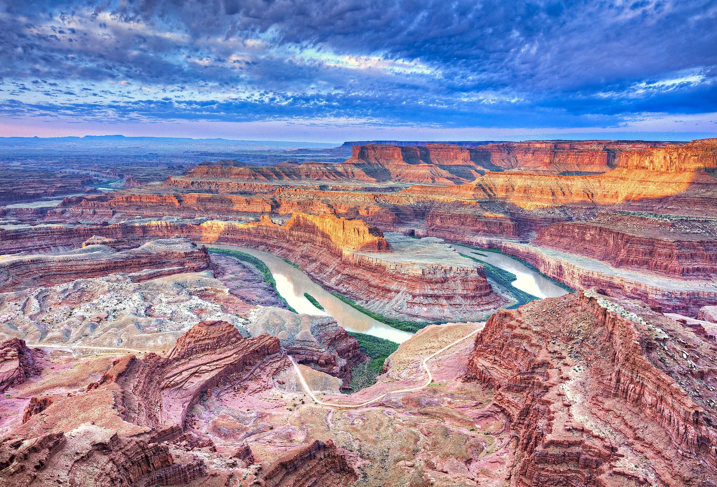
Dead Horse Point, Utah

Plenty of people drive to Moab, about 30 miles away, and never make the trip out to Dead Horse Point, which is a mistake. The name comes from a grim piece of local legend: in the late 1800s, cowboys used the narrow neck of the mesa as a natural corral for wild mustangs, fencing off the only way out. As the story goes, one band of horses was left behind on the waterless point and died of thirst within sight of the river far below.
That river is the Colorado, and the view is the reason to come. From the point, the canyon drops about 2,000 feet to a gooseneck bend in the river, with Canyonlands and the La Sal Mountains filling the distance behind it. There are few places where you can take all three in at once.
Turkey Run State Park, Indiana

Turkey Run packs a lot into a small Indiana park: sandstone gorges, big boulders, old stone stairs, and trails that drop into the ravines on built-in ladders. Trail 3, through Bear Hollow and Rocky Hollow, is the rugged classic, with the ladders and the narrow canyon walls. Sugar Creek runs through it all and is good for a paddle, and a suspension bridge crosses the creek to reach the nature preserve on the far side. Pack bug spray, sunscreen, and water. Established in 1916, it is among Indiana's oldest state parks, and its quieter neighbor, Shades State Park, is a short drive away if you want a second helping.
Itasca State Park, Minnesota

Itasca is the oldest state park in Minnesota, established in 1891, and its claim to fame is the spot where the Mississippi River begins. Here the river is a shallow, knee-deep stream, narrow enough to wade, and visitors line up to step across it on a row of stones, the one place you can walk over the Mississippi without getting more than your ankles wet. From this trickle it grows into the longest river in North America; paired with the Missouri, the two form the fourth-longest river system in the world.
The marker at the headwaters puts the river's journey to the Gulf of Mexico at 2,552 miles, a figure from the 1930s that modern surveys have trimmed closer to 2,350; either way, it is a long way to the sea. The park spreads across 32,000 acres and holds more than 100 lakes, Lake Itasca among them, with a swimming beach and easy water for paddling. The 10-mile Wilderness Drive loops past old-growth pine and gives a good feel for the place.
Worth the Detour
The through-line in all nine is the same: a state park sitting in the shadow of a more famous neighbor, holding scenery and stories that match anything next door, usually with room to breathe. The national parks earned their fame for good reason. But the parks here reward the drivers willing to take the side road, and most days they hand it all over without the crowds.