The Longest Dirt Roads In The United States
Nothing says old school adventure quite like a dirt road in the modern world. In 1913, 2 million miles or 90% of the roads in the US were "Earth Roads" as the USDA called them. The great majority of the country was rural, and the direction of innovative energy was aimed at the cities. Today, that ratio has shifted into reverse. Though they are scarcer, dirt roads still signify the place where civilization ends and wilderness begins. What was once the norm is now a novelty. The roads ranked here lack asphalt and gravel alike. The qualifying metric is the retention of a natural earthen base with little alteration beyond piecemeal repairs, and the distances given are the best available estimates of the portions that are drivable today. Five roads still hold an earthen base across a serious distance, and a sixth cross-country route closes the list as a bonus.
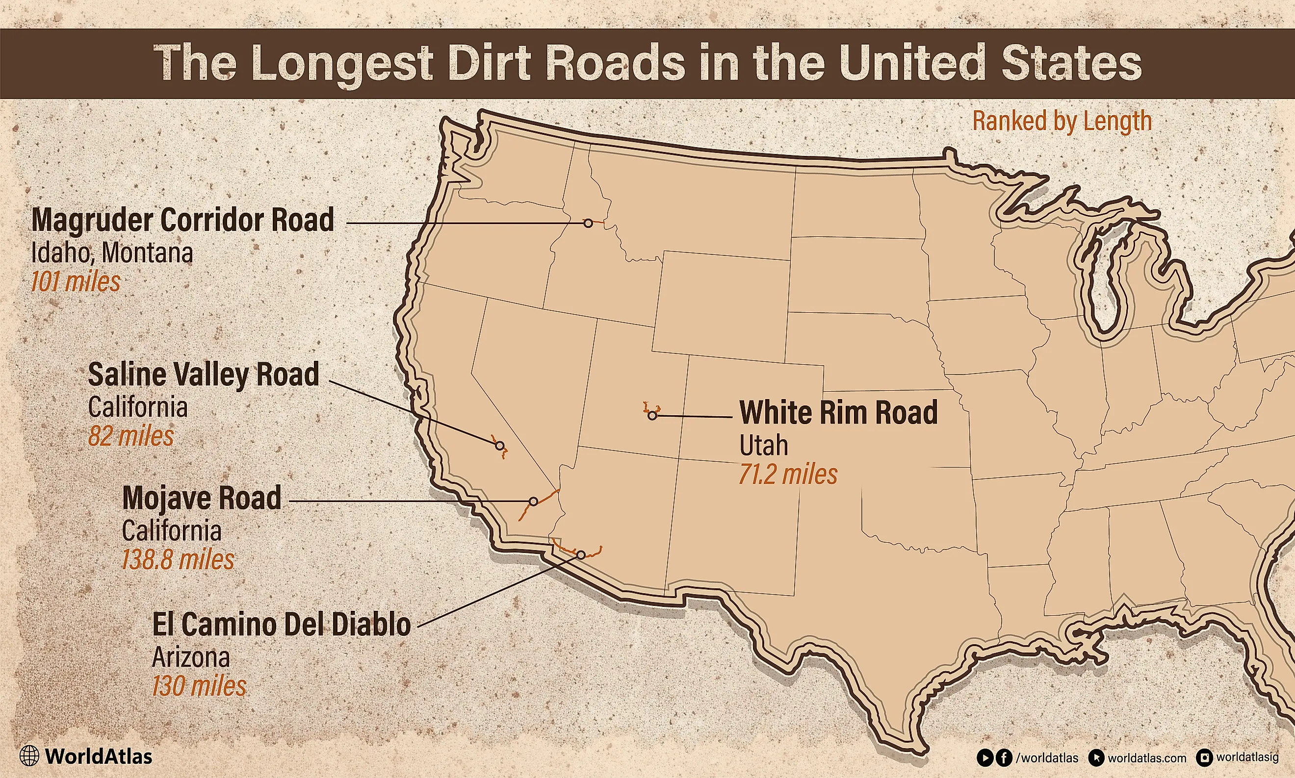
Mojave Road, California (138.8. miles)

In 1975, Dennis Casebier walked the entire length of this dirt road to draw attention to the historic stretch across the Mojave National Preserve, which predates California and originally served as a Mojave Native American trade route that reached all the way to the Pacific. Today it is an east-to-west road, 138.8 miles between the Colorado River and the Mojave River. In March 1776, the year America declared its independence from England, a Spanish friar named Fray Francisco Hermenegildo Garcés mentions the route in a journey led by Mojave guides. Right before the Civil War in 1858, the American army used it as a supply line stretching from Ft Smith, Arkansas, and established 5 army outposts along the road. It was called the "Old Government Road" by cartographers.
In 1883, a railroad was constructed 15 miles south, causing it to be forgotten. Casebier rediscovered the Mojave Road in 1962 after researching old maps. He dedicated himself to identifying, excavating, repairing, and writing about the original route. As a US naval physicist, he brought scientific expertise to bear on restoring the road's integrity. He also opened the Mojave Desert Heritage & Cultural Association, located on his ranch 15 miles south of the Mojave Road. It contains a variety of geographical resources, such as his Mojave Road Guide. There are not many signs along the Mojave Road, just primarily rock cairns signifying landmarks. This was done to discourage heavy automobile traffic from degrading the terrain.
El Camino del Diablo, Arizona (130 miles)

The Devil's Highway is a notorious dirt road in southern Arizona and Mexico that has claimed the lives of between 400 and 2000 people since the Spanish Coronado Expedition in 1540. Many fell victim to extreme heat or dehydration in an area where temperatures go up to 120 degrees Fahrenheit. Most died during periods such as the California Gold Rush beginning in 1849, which lured desperate and daring immigrants from Mexico. However, humans have lived in the area and used the road for 10,000 years or more, and it is impossible to guess how many lives were lost and never reported.
The American portion of the road lies within the Cabeza Prieta National Wildlife Refuge, which runs along the border between Mexico and Arizona, with some overlap into the Barry M. Goldwater bombing range operated by the Marine Corps Air Station (MCAS). On the US side, the road connects the border town of Sonoyta with the town of Yuma, where the Colorado River and Gila River converge, for a 130-mile span. The original distance of the road from Yuma to its Mexican origin in Caborca was 250 miles. The US Fish & Wildlife Service currently allows only high-clearance, 4-wheel-drive Off-Highway Vehicles (OHVs) to drive along El Camino del Diablo, since there are no emergency services or tow companies that will go there. Visitors can still hike or bike along the road, despite considerable warnings that individuals do so at their own risk.
Magruder Corridor Road, Idaho-Montana (101 miles)
The Magruder Corridor Road was formally preserved as a permanent dirt road in its unusual position between two wilderness areas under the Central Idaho Wilderness Act of 1980. It is a mountain ridge road that runs between the Red River Ranger Station of the Nez Perce National Forest near Elk City, Idaho, to the West Fork Ranger Station 18 miles southwest of Darby, Montana. It is sometimes referred to as the Southern Nez Perce Trail. The Nez Perce Trail is the 1,170-mile track through Oregon, Idaho, Wyoming, and Montana, along which Chief Joseph and the Nez Perce tribe fled in 1877, attempting to elude U.S. cavalry forces in pursuit, when they had refused to relocate to a reservation from their native lands in Oregon's Wallowa Valley.
The dirt road that makes up the Magruder Corridor portion of this historic route connects the 1.2 million-acre Selway-Bitterroot Wilderness to the north and the 2.3 million-acre Frank Church-River of No Return Wilderness to the south. In the 1930s, the Civilian Conservation Corps (CCC) widened the road to its current width. The road is named for Lloyd Magruder, a successful gold miner from Elk City, Idaho, who was murdered at mile 44.2 of the road in 1863 by 4 guards he had hired as escorts to protect him. They conspired to steal gold he reportedly had from panning discoveries along the Selway River. The perpetrators were caught, found guilty in a court, and were the first official executions by hanging in the Idaho Territory.
Saline Valley Road, California (82 miles)

The remote Saline Valley Road lies in Death Valley National Park, midway between Las Vegas, Nevada, and Fresno, California. Commercial trail-mapping service onX's digital estimates rate the length of the Saline Valley Road at 78.2 miles, which is slightly below Inyo County's official measurement of 82.07 miles, calculated by combining three primary segments of the road's makeup between State Route (SR) 190 and Death Valley Road. Today, this dirt road is primarily a thoroughfare for wilderness enthusiasts and park rangers. There is an oasis in this desert region containing hot springs that were historically valuable to the Timbisha Shoshone peoples.
The dirt road was first constructed in 1911 to support the 13-mile aerial tram for Saline Valley Salt Company, which was needed to transport salt up and down 7600 ft of elevation in the Inyo Mountains. Portions of the road in the form of rough trails are known to have existed as far back as the late 1800s, when prospectors sought borax and sodium chloride deposits in the Inyo Mountains. By 1936, the road was closed to commercial traffic, as transporting salt from such heights posed too many challenges to make continued business use profitable. In the 1960s, the area was popular for hippies who wanted to escape the grid and enjoy the natural hot springs. There is no cellphone service, and serious precautions regarding potable water, food, fuel, and spare tires for mechanized off-road vehicles are necessary for prolonged stays in the area.
White Rim Road, Utah (71.2 miles)

White Rim Road lies within the Islands in the Sky district of Canyonlands National Park in eastern Utah. Technically, the pure dirt road portion is a 71.2-mile stretch between the junction with the Shafer Trail and Potash Road on the eastern side and the junction with Mineral Bottom Road on the western side. It is sometimes given extra padding at 89 miles when connected to other adjoining dirt roads or within a larger, oft-referenced mixed-surface loop of 100 miles. According to National Park Service (NPS) guidelines, off-road 4-wheel-drive vehicles can generally cover the entire distance comfortably in two days, while mountain bikers take four days.
The road is susceptible to seasonal flooding and muddy areas. Spring and fall are the most popular times of the year to visit to avoid 100-degree Fahrenheit weather during the summer. There is no water source along the road, so travelers should be adequately prepared by bringing their own water. There are adequate signs, and the road is easy to recognize in contrast to the surrounding terrain. The road, as it is now configured, was developed as part of a Cold War-era network constructed or widened by the Atomic Energy Commission during the Uranium boom of the 1950s. However, very little Uranium was ever found in this area. Now it is a popular recreational excursion and functional as a travel route through the Canyonlands National Park.
Trans-America Trail (5,900+ miles)

Though sometimes referred to as "the 5,000-mile dirt road," the TransAm Trail (TAT) is included here more as a dirt-road bonus than as an actual "longest dirt road" contender, given its unique history commemorating the enduring off-road experience of traveling rural roads in America. In 1984, motorcycle enthusiast Sam Correro began creating a route across the country from Tennessee to Oregon. Over the next decade, he stitched together 4,500 miles of backcountry, forest, and farm dirt roads based on personal exploration and existing maps, well before the advent of GPS. Truth be told, however, there are portions of paved and gravel roads included in the mix that would obviously disqualify it for this article.
Yet it represents a fascinating human-interest story and a successful attempt to navigate across the continental United States, primarily using dirt roads. Interest in the TransAm Trail continued to grow, making it a popular journey that inspires many outdoor enthusiasts. Correro mapped additional ocean spurs connecting the Pacific and Atlantic Oceans. With GPS, even novices to the trail can easily plug into the itinerary and follow along for the ultimate cross-country adventure. There are no signs marking the trail, which can only be reached by those "in the know." In 2025, Ford sponsored a 3-vehicle trek across the TAT that took 32 days, with the current mileage reported at 5,900 miles. The massive collection of thousands of dirt road connections continues to grow.
Staying Onroad in Offroad Mode
Beyond the transition between asphalt and raw earth, intrepid explorers have shown a wanderlust for the experiences that lie in following a dirt road and daring to enter a more primitive environment. This does not seem to be a fading interest, considering the active efforts to recover many of these older roads. It is remarkable that all of the roads considered here, excepting the TransAm Trail, lie in the broader expanses of desert or mountain wilderness in the Southwest and Northwest. It seems that more fertile or less drastic conditions back east have concentrated civilization to the point that paved surfaces are required along any significant length of usable road.
However, many smaller dirt roads remain, especially in the rural south and Midwest. Some significant rough roads were bypassed in this study, such as the 414-mile Dalton Highway and the 132-mile Denali Highway in Alaska, since both are primarily gravel roads with paved segments, which disqualifies them from the "Earth Road" status of the top 5 selected here. A road signifies that "this way" or "that way" goes somewhere. However, that somewhere could be lost in time, and you may end up going nowhere. Yet even that may be therapeutic in today's over-congested, over-regulated, and over-mechanized cosmopolitan environments. Cellphone service is frequently unavailable in these areas. Stargazing is usually better with dark skies untainted by artificial light. A dirt road going nowhere might be the most exciting, peaceful, and healthy destination of all.




.jpg)