8 Great Road Trips to Take in California's Sierra Nevada
California's Sierra Nevada region has some of the most striking natural beauty in the state, from the alpine Tuolumne Meadows at Yosemite National Park to the blue waters of Lake Tahoe. Take a brief ride on an old-fashioned train in summertime on the Feather River Scenic Byway, to give you a break from driving, or ride through abundant apple country on El Dorado County, Route 50 and venture through the conifer trees of Eldorado National Forest.
Feather River Scenic Byway

A route officially designated by the Federal Highway Administration, the Feather River Scenic Byway spans around 130 to 135 miles, about 10 minutes from the Nevada border, north of the Tahoe National Forest. If taking the eastern route, repeat the steps below in reverse order.
Begin the journey by turning off Highway 395 at Hallelujah Junction onto Route 70 and head westward, reaching Beckwourth Pass at 5,221 feet less than 5 minutes later. This area is characterized by the dry golden hills of the Sierra Valley and the peaks of the blue-tinted Diamond Mountains on the horizon, driving through the rural communities of Chilcoot-Vinton, Beckwourth, where drivers will catch up with the Middle Fork Feather River, and Portola, before reaching Blairsden. Of specific note is Portola, where there is a Western Pacific Railroad Museum, which also offers weekend train rides in summer, in addition to providing insight into Northern California's railroad roots. Portola is also where parched steppe gives way to denser pine growth. And in Blairsden, the final destination, The Brewing Lair is great for tasting ales. Sierra Smokeshow serves up barbecued meats, Grizzly Grill cooks American fare all day, and the Middle Fork Feather River is there for all kinds of outdoor activities. The Feather River Scenic Byway highlights the way modern mountain life has been built around the Middle Fork Feather River, as well as the transition from a barren environment into fuller, lusher surroundings.
Yuba-Donner Scenic Byway

The roughly 160 miles of the Yuba-Donner Scenic Byway in Northern California encircles some of the 850,000 acres of Tahoe National Forest. As it is a circular route, drivers can start from different places on it. For the sake of convenience for those who might be traveling from Lake Tahoe, some drivers may opt to start in Truckee and go in a circle up through Sierraville on the northeastern side and Nevada City on the southwestern side, which will land you back in Truckee.
If choosing this route, first you will reach Highway 49's Yuba Pass at 6,709 feet by the North Yuba River, winding through the coniferous and deciduous trees. Pass Schroeder Mountain, usually covered in vegetation, and a number of trails worth exploring, like the challenging 5.8-mile single-track Hall's Ranch Trail through Fiddle Creek Ridge. Additionally, the Hoyt Trail crossing over the South Yuba River may also appeal to hikers, and to swimmers when the weather is warm. 15 minutes later, Nevada City might spark an interest in a mining and railroad history lesson. Within an hour, reach Truckee after passing through Donner Summit and Donner Lake, where drivers might see remnants of the transcontinental railroad. The Yuba-Donner Scenic Byway is one of the best routes for winter recreation, as the Donner Summit SNO-Park is not far from Truckee, and showcases the sugar pines and red firs of the Tahoe National Forest.
Monitor Pass/Luther Pass/Lake Tahoe Road, Route 89

Coming from the northern segment of the route, the Monitor Pass/Luther Pass/Lake Tahoe Road on Route 89 curves around the southwestern side of the freshwater body of Lake Tahoe down into Tahoe Valley through Markleeville and the Heenan Lake Wildlife Area, finally zig-zagging until Monitor Pass comes into view.
Be graced by the shoreside beauty of Lake Tahoe at Sugar Pine Point Beach, continuing down to D. L. Bliss State Park, where hiking, camping, and swimming are popular in summertime, taking in the turquoise waters of Lake Tahoe. Five minutes south, Vikingsholm on Emerald Bay is a Nordic-inspired castle across from the Fannette Island Tea House. And about 30 minutes further is the Tallac Historic Site, which preserves three early 20th-century summer estates now managed by the USDA Forest Service. Down through Tahoe Valley, reach Markleeville 40 minutes later to see the 1928 Romanesque Revival-style Alpine County Courthouse and the Alpine County Museum and Historical Complex, documenting the region's pioneering and mining history with antique machines and buildings like an old schoolhouse. Having driven through the pine-covered Route 89 along Monitor Creek, make your way to Monitor Pass at 8,314 feet in the dry, high-altitude Sierra Nevada landscape, coming all the way from the blue waters of Lake Tahoe and the alpine mountaineering villages.
El Dorado County, Route 50

With the California capital of Sacramento to the west and the Sierra Nevada Mountains to the east, El Dorado County, Route 50 officially begins in central Placerville and features the Eldorado National Forest, weaving through isolated mountain communities of Pollock Pines and Twin Bridges before reaching South Lake Tahoe.
Leave the 19th-century gold mining city of Placerville and drive through the wooded countryside abundant with apple orchards. Bridal Veil Falls in Pollock Pines, 20 minutes away from Placerville, is a great picnicking and swimming opportunity. Less than 20 minutes from Bridal Veil Falls, the South Fork Observation Spot displays wonderful views of the South Fork American River with the mixed conifer trees and grasses of the Eldorado National Forest. Half an hour later, cruise around Lower Echo Lake and the Echo Lake Sno-Park, renowned for winter sports and a selection of forested hikes, and pass a trailhead of the Pacific Crest Trail. Arrive at the center of South Lake Tahoe in about 15 minutes, having traveled the 58 miles of El Dorado County, Route 50, leaving gold mining and apple country behind for lakeside recreation close to the Nevada border.
Carson Pass Scenic Byway, Route 88

Although sometimes closed in winter, the Carson Pass Scenic Byway, Route 88, has a wide range of scenery along its designated 58 miles. The full drive described here starts in Stockton in the Central Valley and climbs into the Sierra Nevada Mountains before reaching the California-Nevada border.
From Stockton, drive through semi-rural establishments like Lockeford along the Mokelumne River, past the Camanche Reservoir. Avio Vineyards in Sutter Creek is an hour from Stockton, meant for a classic experience of rolling through Northern Californian wine country, and 17 minutes away in Pioneer, Plate 88 American Grill & Bar is a good idea for a tasty breakfast, lunch, or dinner. A further 16 minutes, Cook's Station is a popular dining spot for takers of this route, now formally in the part of the route where tall pine trees line the road on both sides, having left civilization. Up ahead about 12 minutes, Peddler Hill Overlook shows off a view of the Lower Bear River Reservoir in the Eldorado National Forest. Nine minutes up the road, Maiden's Grave marks a tragedy of early pioneering, and a host of nearby trails suggest opportunities around nearby Silver Lake, Thunder Mountain, and Kirkwood Mountain Resort by Caples Lake. Get to Carson Pass and its dramatic Sierra Nevada Mountains, sometimes with their peaks covered in snow, in under 10 minutes from Kirkwood Mountain Resort, achieving the high point of this journey before going through Hope Valley and Sorensens and finally reaching the state line.
Tioga Road, Route 120

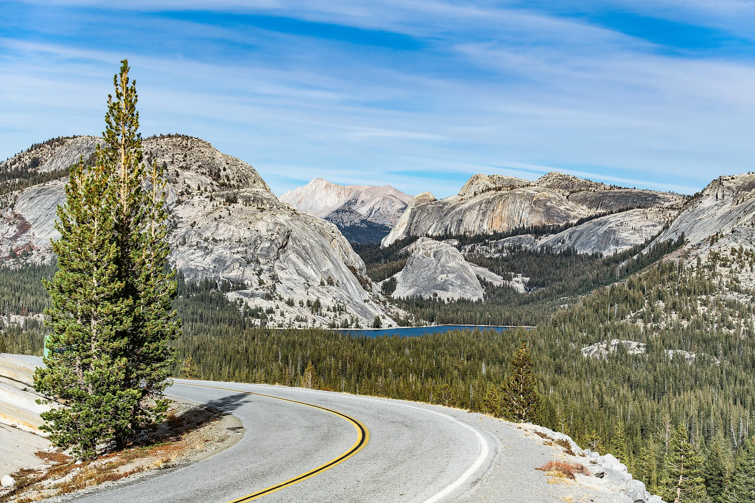
Journey through Stanislaus National Forest and Yosemite National Park up to Tioga Pass on Tioga Road, Route 120, through the towering sequoias and alpine Tuolumne Meadows of the Sierra Nevada Mountains.
Begin right around where Evergreen Road turns onto Highway 120, heading down through Crane Flat Lookout and the Tuolumne Grove, where two dozen sequoia trees have been standing for thousands of years. About 20 minutes on Tioga Road, White Wolf Campground and Lukens Lake Trailhead, which can be muddy until August, will appeal to campers, hikers, and photographers on this route, but are best visited outside of winter. A little over 20 minutes further lies Tenaya Lake and Clouds Rest, two popular Yosemite National Park spots, the latter of which is a rather challenging 14-mile round-trip hike with amazing views of Half Dome, while Tenaya Lake is commonly used for boating and swimming in summer. 10 minutes away, Tuolumne Meadows and Lembert Dome await, two of the many wonders of Yosemite National Park. The journey ends when you reach the western side of Mount Dana a little over 7 miles away at Tioga Pass, having seen some of the natural beauty that makes the Sierra Nevada Mountains so spectacular.
Eastern Sierra Scenic Byway

On the Eastern Sierra Scenic Byway, drive northeast from the inland desert climate of Bishop, California, from the Owens Valley up through Lake Crowley, Mono Lake, and Mt Patterson before reaching Topaz Lake on the California-Nevada border, in around 130 miles.
Bishop is Inyo County's only city, a rich agricultural hub in the Owens Valley. This is where drivers will leave town and embark on the first leg of the journey, reaching a northbound vista point overlooking the grey ridges of the Eastern Sierra as the highway climbs out of the Owens Valley. 13 minutes onward, meet Lake Crowley where fishing, picnicking, and camping opportunities arise, as well as a chance to see the Crowley Lake Columns, which formed out of volcanic activity some 760,000 years ago, unless the beach is flooded. Less than 20 minutes away is Mammoth Lakes, home to much-loved seasonal resort, Mammoth Mountain, and half an hour further is Mono Lake Tufa State Nature Reserve, with unusual calcium-carbonate formations and clear blue alkaline water. Over an hour later, Topaz Lake will be the final destination of the Eastern Sierra Scenic Byway, but in Coleville, take advantage of the Shingle Mill Flat Picnic Site for a meal in the Humboldt-Toiyabe National Forest on the banks of the West Walker River, not far from Mt Patterson and a number of beautiful hiking trails in the Eastern Sierra.
Sierra Vista Scenic Byway

The Sierra Vista Scenic Byway completes almost a full 100-mile loop around the alpines and conifers of the Sierra National Forest and Ansel Adams Wilderness, beginning in North Fork and ending at the confluence of Highway 41 and Road 632 in Oakhurst.
In North Fork, there are a few different cultural sites to check out, like the Sierra Mono Museum, documenting Native American artifacts from the area, or the 1860 log structure of Jesse Ross Cabin about half an hour into your journey outside of town, having passed just above the Exact Center of California. 25 minutes later, see the Minarets, Mammoth Mountain, and Mammoth Pool Reservoir at Mile High Vista. Within the hour it takes to get from here to Portuguese Overlook, drivers will see Jackass Rock and Arch Rock Interpretive Site, including the campgrounds, which is a good idea for extending your stay or enjoying a brief picnic. Portuguese Overlook provides views of silver-tipped red firs and the curved granite rocks. 12 minutes down Beasore Road, Globe Rock is an interesting boulder that many people visit for a photo op, and an additional 20 minutes leaves drivers at the highest point of the route at 7,326 feet high at Cold Springs Summit Interpretive Site. Begin the descent to Oakhurst, reaching Fresno Dome Vista 6.5 miles later, and follow Road 632 over the Lewis Fork back to Highway 41, which concludes the Sierra Vista Scenic Byway.
Brave the Sierra Nevada Mountains
If the pioneers and mountaineers traveled these same routes, so can you. The Sierra Nevada Mountains' roads may be significantly improved now, but these eight road trips propose a variety of natural scenery and obstacles. Make the trip outside of winter, or dare to encounter the harsher conditions of California mountain life.