The Deepest Point In The Ocean
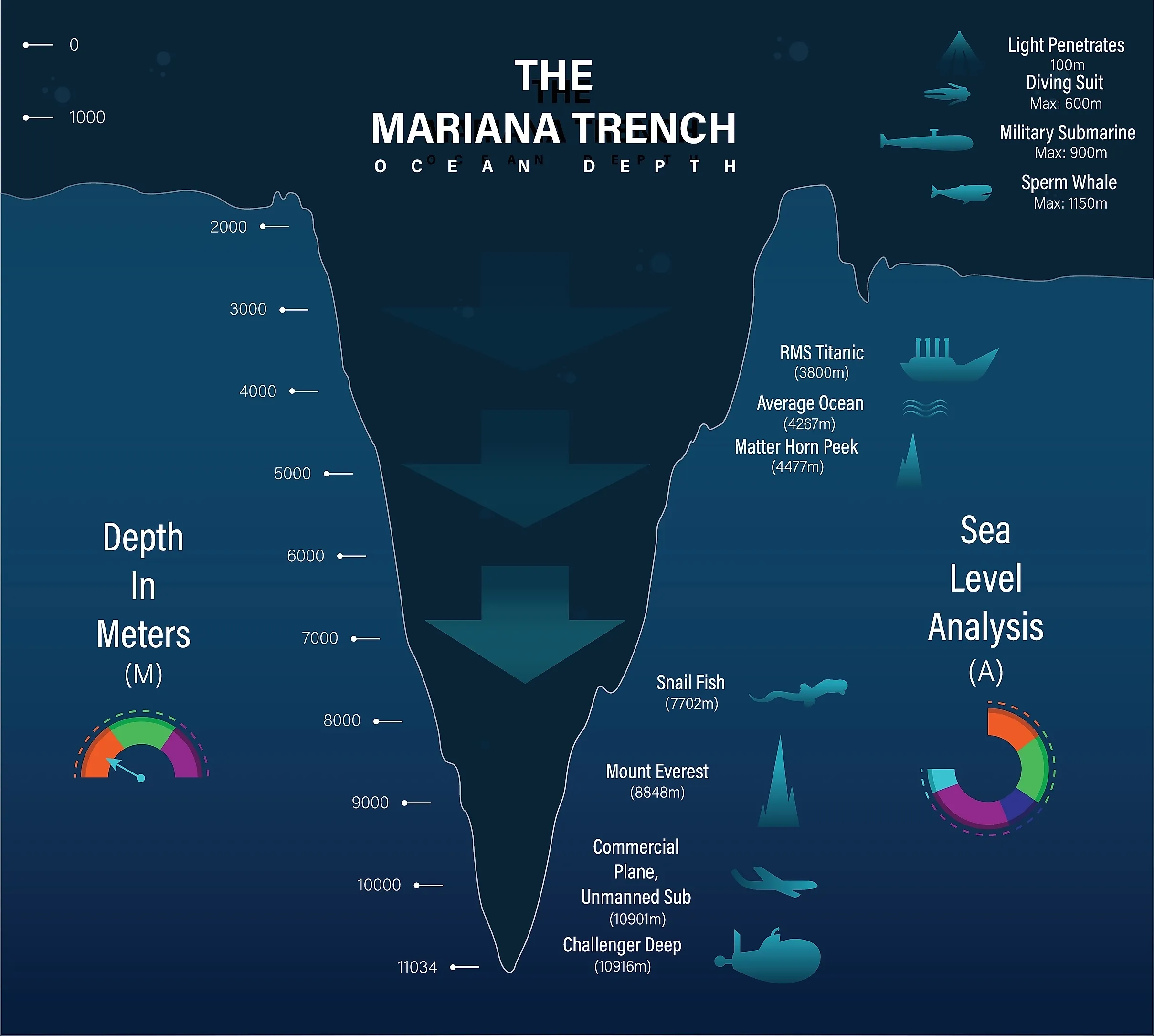
The Mariana Trench is the deepest ocean trench on Earth, located in the Pacific Ocean east of the Mariana Islands archipelago. The deepest section of the Mariana Trench, and therefore the deepest point in the ocean, is Challenger Deep, itself located southwest of the US territory of Guam. According to the National Oceanic and Atmospheric Administration (NOAA), the average depth of the Pacific Ocean is approximately 13,000 ft (4,000 m), while Challenger Deep is about 35,876 ft (10,935 m) in depth, almost seven miles.
The trench's deepest parts support life; scientists have identified xenophyophores, amphipods, sea cucumbers, and other organisms that have adapted to the extreme conditions of the hadal zone, the deepest region of the ocean. The snailfish is the deepest-known vertebrate, found at roughly 27,00 ft (8,336 m). The depth limit lies at around 26,900 to 27,600 ft (8,200 to 8,400 m). No fish or other vertebrates have been discovered yet living deeper than this. In deeper environments, such as Challenger Deep, invertebrates and microorganisms are among the life forms documented so far.
How Ocean Depths Are Measured

The Pacific is the deepest ocean basin on Earth, and it has both the greatest average depth and the lowest absolute point. The Pacific Ocean's average depth is approximately 13,000 ft (4,000 m). In comparison, the shallowest ocean, the Arctic Ocean, has an average depth of about 3,950 ft (1,200 m). Modern sonar systems use the speed of sound in water (about 1,500 meters per second) to measure return time and calculate distance. Satellite altimetry also helps map the ocean floor indirectly. Radar altimeters detect tiny variations in ocean surface height caused by Earth's gravity associated with underwater mountains, trenches, and other large features, allowing for estimates of the broad shape of the ocean floor. Aircraft using green laser light pulses, called airborne LiDAR, are an efficient method of measuring depths in shallow waters. Historically, lead lines, heavy weights attached to marked ropes, were used to measure depth.
As such depths are difficult for most people to imagine, a common comparison is Mount Everest. At 29,031.7 ft (8,848.86 m), Everest is the highest peak on Earth, measured relative to sea level. Hawaii's Mauna Kea rises 13,765 ft (4,205 m) above sea level. However, its total height from the ocean floor to the summit is more than 32,000 ft (9,800 m), and more than half of the mountain lies beneath the ocean. Mount Everest is the standard for comparisons as it is easier to visualize. If Mount Everest were to be placed in Challenger Deep, the summit would be covered by more than 1.2 miles (2 km) of water. Challenger Deep extends farther below sea level than Mount Everest rises above it.
The Mariana Trench

The Mariana Trench is a crescent-shaped impression in the Earth's crust in the western Pacific Ocean, east of the Mariana Islands. As the deepest ocean trench on Earth, the Mariana Trench is the absolute lowest zone of the Earth's surface. The trench's maximum depth is at what is called Challenger Deep, measuring around 35,876 ft (10,935 m) at its deepest point. The trench is around 1,500 miles (2,550 km) in length but is far narrower at 43 miles (69 km) on average. The water pressure reaches over 15,750 psi (1,086 bar), exceeding 1,000 times the atmospheric pressure at sea level. This is enough pressure to crush a submarine not designed for such depths. As sunlight cannot penetrate deeper than around 3,280 ft (1,000 m), Challenger Deep is in pitch-black darkness. The water temperatures hover just above freezing, averaging 39°F (4°C).
The Mariana Trench formed at a convergent plate boundary, where the Pacific Plate is being subducted beneath the Philippine Sea Plate. The Pacific Plate moved westward relative to the surrounding plates, bending downward and descending into the Earth's mantle. As the plate pulls down on the overriding plate, it creates a deep and steep-sided depression. The plates continue to move, and the Mariana subduction zone is an active geological system continually reshaping the trench and ocean floor. Deep-sea snailfish can survive in the shallower parts of the hadal zone, with the deepest confirmed sighting of fish happening at 27,000 ft (8,336 m). Below this proposed depth limit, animals discovered have been invertebrates, such as sea cucumbers, amphipods, and isopods, as well as microorganisms.
Challenger Deep
The deepest known point in the ocean is located at the southern end of the Mariana Trench. Challenger Deep is located around 200 miles (322 km) from Guam in the western North Pacific Ocean. The north slopes of Challenger Deep lie just east of the United States' Mariana Trench Marine National Monument, in the territorial waters of the Federated States of Micronesia. NOAA places the estimated depth of Challenger Deep at 35,876 ft (10,935 m). Recent surveys have revealed that Challenger Deep has three depressions named the Western, Central, and Eastern basins. Challenger Deep was named in honor of the HMS Challenger, a British Royal Navy survey ship. The crew performed the first recorded soundings of the trench floor in 1875, using weighted ropes.
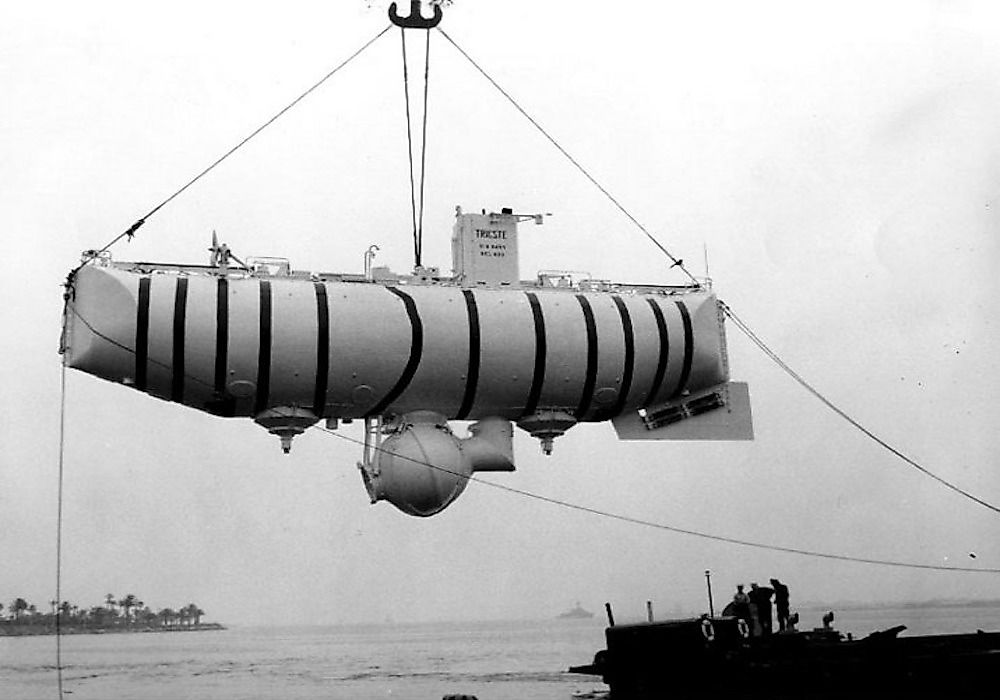
The first humans to reach the bottom of Challenger Deep were US Navy Lieutenant Don Walsh and Swiss scientist and engineer Jacques Piccard, who piloted their vessel Trieste to the bottom in January 1960. They remained at that depth for 20 minutes. According to the US Navy, a viewing port cracked, requiring an ascent earlier than planned. It was 52 years later when the next dive took place. Canadian filmmaker James Cameron became the first person to complete a solo descent in 2012, in the vessel Deepsea Challenger. Victor Vescovo, a retired US naval officer, visited Challenger Deep in a series of dives between 2019 and 2022. His submersible was the DSV Limiting Factor, and Vescovo took along scientists, explorers, and others during his trips. In 2020, former NASA astronaut Kathryn Sullivan became the first woman to visit Challenger Deep in one of Vescovo's dives. Sullivan is also the first person to both walk in space and descend to the ocean's deepest point.
Still Much To Discover
The world's oceans cover around 71% of Earth's surface, yet mapping the ocean floor remains difficult. Satellite missions have charted 100% of Mars' surface, down to a resolution revealing sand dunes. Yet, according to figures published by the NOAA Office of Ocean Exploration and Research, as of April 2026, 28.7% of Earth's global ocean floor has been mapped using modern, high-resolution standards. All of the ocean has been mapped using satellite-derived data, but the maps only provide a limited picture of the surface.