Where The Water In The Great Lakes Actually Comes From
Ask where the water in the Great Lakes comes from and most people picture rivers, some network of mighty inflows feeding the inland seas the way the Mississippi feeds the Gulf. The real answer is stranger on every count. No great river fills the Great Lakes; the land around them drains a startlingly thin strip; the biggest single source of new water is rain and snow falling directly onto the lakes themselves; and all of that new supply together replaces less than one percent of the water in any given year. The other 99-plus percent is inheritance, the meltwater of the ice sheet that carved the basins and died filling them about 10,000 years ago. The Great Lakes are not primarily a flow. They are a bequest, still sitting in the account, and understanding that changes how the whole system reads.
The Rivers Barely Matter

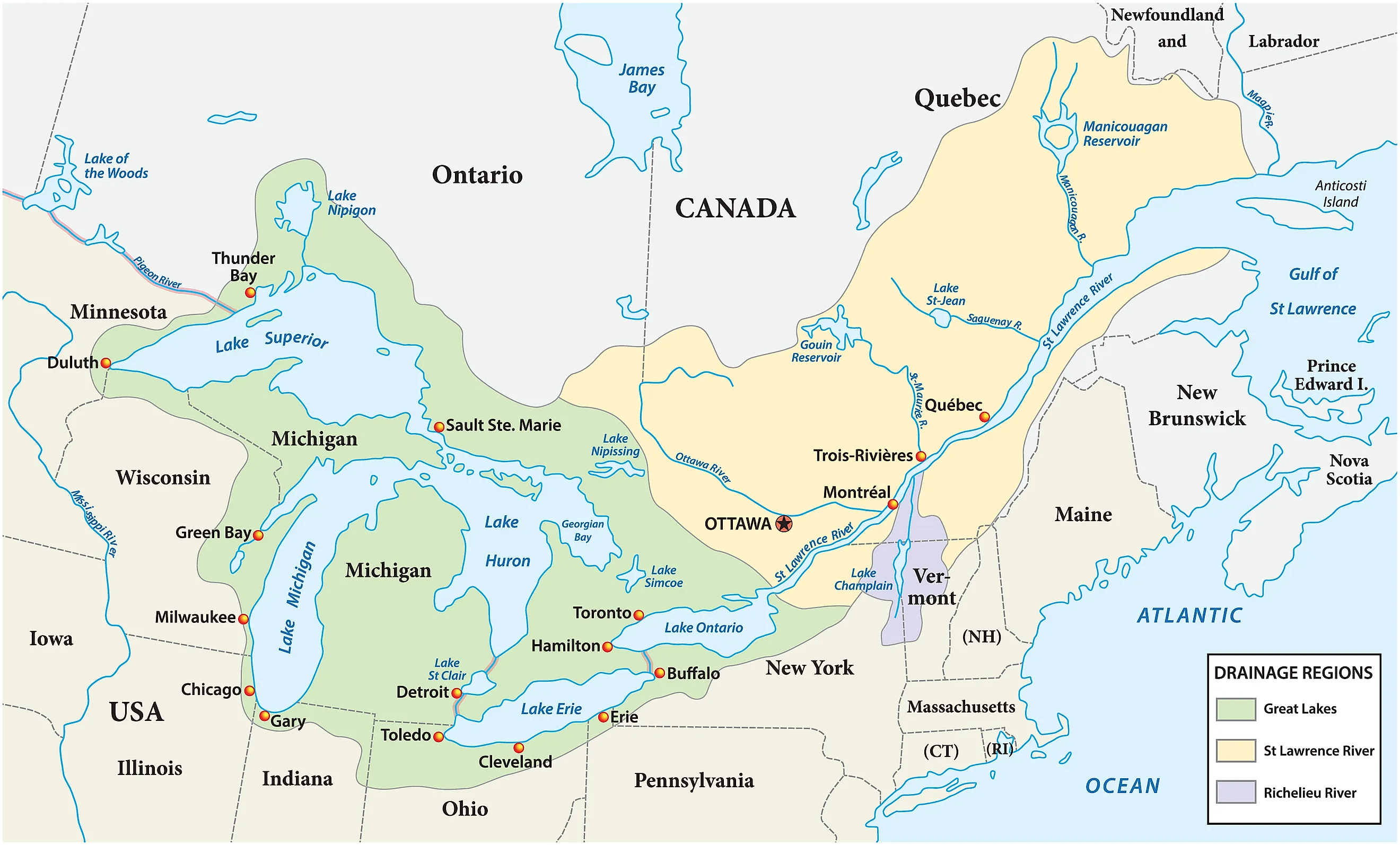
Here is the fact that breaks the mental map: the Great Lakes have one of the smallest drainage basins, relative to their size, of any major lake system on Earth. The land that actually sheds water into the lakes is a modest rim, roughly twice the area of the lakes themselves, where most great water bodies command catchments ten or 50 times their size, and the divide runs absurdly close to shore in places. Stand a few dozen miles southwest of Lake Michigan in Indiana and the rain at your feet is bound for the Gulf of Mexico; cross northern Ontario and the streams have already given up on the lakes and turned for Hudson Bay.
Within that thin rim, no single river dominates. The lakes' tributaries are hundreds of middling streams, the Nipigon, the Grand, the Fox, the Saginaw, the Maumee, delivering their shares without any of them mattering much alone, and the combined runoff from all of them is merely one input among several rather than the engine of the system. The lakes, in other words, were never really filled by their rivers, which raises the obvious question of what did fill them.
Most Of The New Water Falls Straight In

Because the lakes are so enormous, more than 94,000 square miles of surface, the sky delivers to them directly, and precipitation falling straight onto the water ranks with basin runoff as a leading source of each year's new supply, with Superior drawing roughly half its annual income as rain and snow on its own face. Groundwater seeps in a quieter third share along the margins. The arithmetic is almost comically direct for something so vast: the main way new water enters the Great Lakes is by landing on them.
The sky also runs the biggest withdrawal. Evaporation takes an enormous bite each year, peaking not in summer but in early winter, when cold, dry air pours across still-warm water and strips moisture at ferocious rates, and the region sees exactly where that water goes, because much of it falls right back as lake-effect snow on the downwind shores. The famous snowbelts of Buffalo and the UP are, quite literally, the lakes leaking onto the land, the system's own water recycling in the most theatrical way available.
The Ice Age Paid The Principal
So if today's inflows are modest, where did 5,400 cubic miles of water come from? The Ice Age, in two installments. First the basins: continental glaciers up to a mile thick bulldozed south along old river valleys and weak rock, gouging the deep hollows, with Superior's bed excavated from the trough of the billion-year-old Midcontinent Rift, the ancient scar where North America once began to split apart. Then the filling: as the ice sheet collapsed between roughly 14,000 and 9,000 years ago, its meltwater pooled against the retreating front in a series of giant predecessor lakes, sloshing through different outlets as the land rebounded, before settling into the five-lake arrangement the modern map shows.
That origin is why the renewal number matters so much. With less than one percent of the volume replaced annually by rain, runoff, and groundwater combined, the water in the lakes today is overwhelmingly that same glacial legacy, passed down and topped off, which is why hydrologists talk about the Great Lakes the way accountants talk about an endowment: the precipitation is the interest, the glacier paid the principal, and a withdrawal that outruns the interest comes straight out of an inheritance no one can refill.
The 191-Year Drop

The system does drain, in a slow staircase to the sea: Superior spills down the St. Marys past the Soo into Michigan-Huron, which are one lake hydrologically, joined at the Straits; their water slides down the St. Clair and Detroit rivers into Erie, plunges over Niagara into Ontario, and finally exits down the St. Lawrence to the Atlantic. But the staircase moves at geological patience. A drop of water entering Lake Superior waits, on average, 191 years before leaving it, Michigan holds its water for most of a century, and only quick, shallow Erie turns over fast, flushing in under three years, with Ontario running about six.

Those residence times make the inheritance tangible. Some of the water thundering over Niagara this afternoon fell on the Superior country when the US had 38 states, worked its way down the staircase for a human lifetime and more, and is only now taking its exit. The lakes are less a river system than a procession, and the line is two centuries long at the back.
The Withdrawals Ledger

Humanity's hand on the budget is real but tightly watched. The famous exception is Chicago, which reversed its river over a century ago and has been sending Lake Michigan water down toward the Mississippi ever since, a diversion of roughly two billion gallons a day, large enough that the US Supreme Court capped it by decree and still polices the meter. Cities around the basin drink from the lakes and mostly return what they borrow; the one-way exports are the sensitive category.
That is the logic behind the Great Lakes Compact, the 2008 pact among the eight lake states, paired with Ontario and Quebec, that bans nearly all new diversions of water outside the basin. The rule exists precisely because of the arithmetic above: a system renewed at less than one percent a year can afford to lend its interest and can never afford to export its principal, and the levels already swing feet on natural cycles alone, as the 2010s showed by running record lows and record highs on Michigan-Huron barely six years apart. The endowment is vast, the income is small, and the trustees, for once, read the fine print.
A Glacier, Still Standing
So the honest answer to where the water actually comes from runs in three parts: mostly from an ice sheet that melted into its own excavations 10,000 years ago, topped off each year by rain and snow falling straight onto the lakes and trickling off a surprisingly thin rim of land, with less than one percent of the whole renewed in any year of your life. Every freighter, every beach, every faucet in Chicago and Toronto is drawing on the same inheritance, metered out down a staircase where the slowest drops wait two centuries for their turn at Niagara. The Great Lakes look like weather. They are mostly memory, the last of the Ice Age, still liquid, still exactly where the glacier left it.