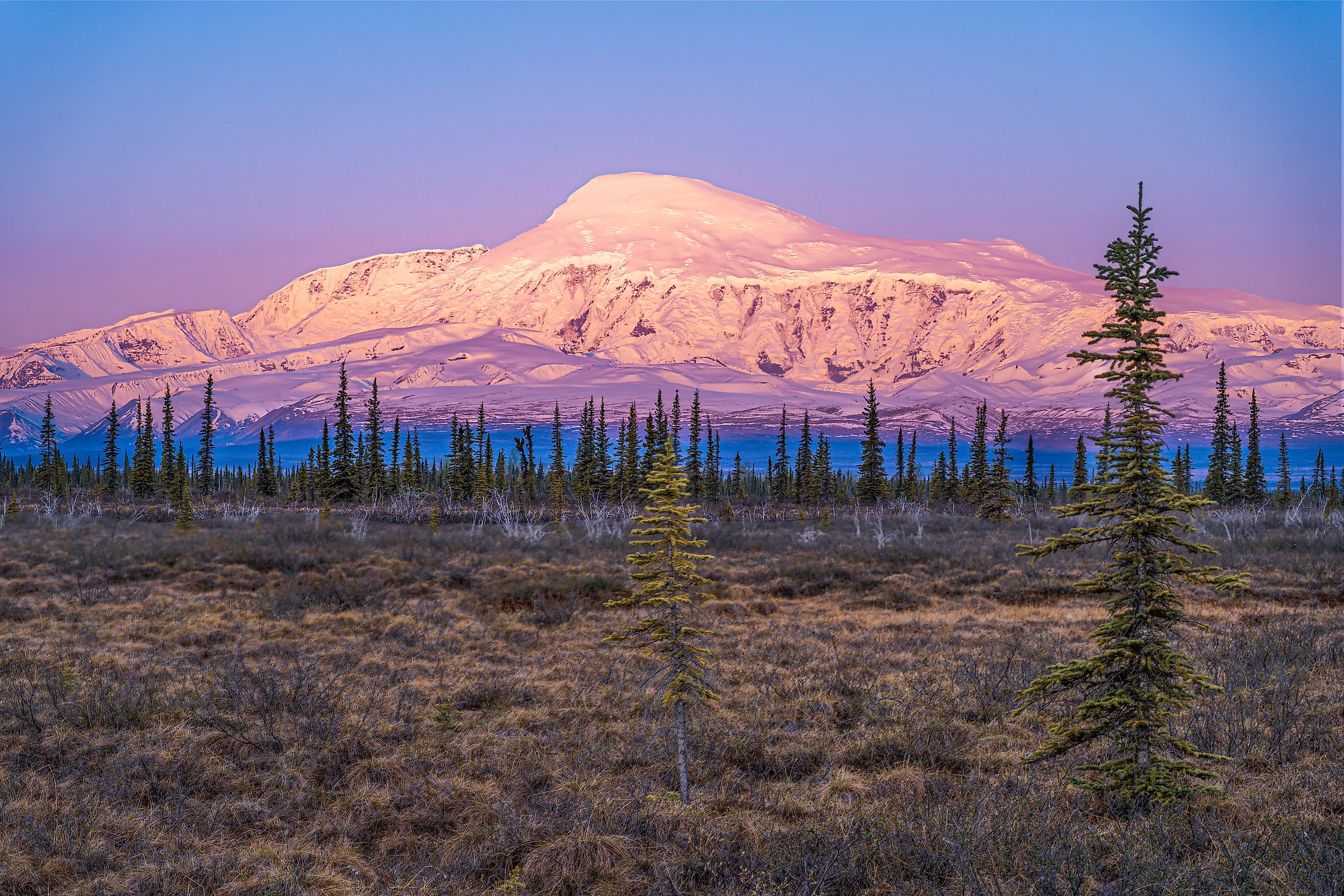
The 10 Highest Volcanoes In Alaska
Belive it or not, Alaska's highest volcano has two official heights, depending on who you ask. The Alaska Volcano Observatory (AVO) lists Mount Bona at 16,421 feet (5,005 meters), the figure that boundary surveyors worked out in 1913. The National Park Service lists 16,550 feet (5,044 meters). Either number makes it the tallest volcano in the United States. Alaska has about 140 volcanoes and volcanic fields in the Alaska Volcano Observatory's catalog. They account for more than three-quarters of all U.S. volcanoes known to have erupted in the past 200 years. The highest of them are bunched together. Six of the ten sit below in the Wrangell volcanic field near the Canadian border, all inside Wrangell-St. Elias National Park and Preserve. Three more rise across Cook Inlet from Anchorage, and one stands alone in the Aleutian Islands.
This ranking follows AVO's catalog, which leaves out Mount Blackburn, the 16,390-foot (4,996-meter) peak that many lists call the country's second-highest volcano. AVO describes Blackburn as the worn-down remnant of an old shield volcano (a broad, gently sloping volcano built from flowing lava) and does not expect it to erupt again. The ten that remain include a mountain whose ash reached all the way to Ireland, a volcano that stopped the engines of a jumbo jet, and another that kept Anchorage on alert for ten months.
Mount Bona

Mount Bona rises at the head of the Hawkins Glacier in the Saint Elias Mountains, about 39 miles east of the town of McCarthy. Its two official heights differ by 129 feet. AVO uses 16,421 feet, the figure Allen Carpé cited in his 1931 account of the first ascent, while the park lists the volcano at 16,550. AVO also lists no known recent eruptions for Bona. That sets it apart from Mount Churchill, about two miles to the northeast, which rises from the same ice-covered mountain mass.
The name came from a sailboat. Prince Luigi Amedeo, Duke of the Abruzzi, spotted the peak in 1897 while making the first ascent of Mount Saint Elias, and he named it after his racing yacht, the Bona. Thirty-three years later, Carpé, Terris Moore, and Andrew Taylor left McCarthy on June 15, 1930, approached from the Russell Glacier, and reached the summit on July 2. Carpé died two years later on Denali's Muldrow Glacier.
No road comes anywhere near the mountain, so climbing parties fly in to Wrangell-St. Elias. The park does not require backcountry permits, though rangers encourage climbers to file an itinerary before they go.
Mount Sanford

At 16,237 feet (4,949 meters), Mount Sanford is the highest volcano in the Wrangell volcanic field. The Ahtna call it Hwniindi K'elt'aeni, which is translated as "upriver K'elt'aeni," a name pointing to its relation to Mount Wrangell to the south. Sanford is a large, dissected shield built on at least three older shield volcanoes, and snow and ice cover most of it above about 8,200 feet. The pattern breaks on the south side. At the head of the Sanford Glacier, a great amphitheater rises more than 7,800 feet in less than a mile, and it is the main window geologists have into the mountain's interior.
That same wall keeps producing false eruption alarms. In April 1981, nearby residents and airline pilots reported an eruption that a University of Alaska scientist traced instead to a huge landslide. AVO has since logged other plumes from avalanches and debris falls on the south face. In March 2009, a cloud streaming off the summit set off a flurry of calls from Copper River Basin residents, and AVO identified it as an orographic cloud, formed as air was forced up and over the peak.
Terris Moore and Bradford Washburn made the first ascent on July 21, 1938. Horses carried the party's gear up the Sheep Creek valley to about 6,000 feet before the climbers continued on skis up a glacier they named the Sunset Glacier.
Mount Churchill

Mount Churchill stands 15,638 feet (4,766 meters) and did not get its name until 1965, when the Alaska State Legislature named it for Winston Churchill in the year of his death. Its summit holds an ice-filled caldera about 1.9 miles (3 kilometers) wide. That caldera is the source of the White River Ash, the product of two of the largest known explosive eruptions in North America.
The two eruptions likely produced more than 30 cubic kilometers of ash combined. The earlier one spread ash more than 300 miles north. The later one carried ash more than 600 miles east. In road cuts along the Klondike Highway in the Yukon, White River Ash is more than two feet thick. Researchers have since matched an ash layer first found in Irish peat bogs and a Greenland ice core to the later eruption.
Pinning the ash to Churchill took a long time. Explorer Frederick Schwatka described the deposits in 1885, but USGS geologists did not propose Churchill as the source until 1992. Some researchers have suggested this ashfall pushed Athabaskan-speaking people south toward the American Southwest. Other researchers have found no lasting climate or societal effects beyond the region near the volcano.
Mount Wrangell

Mount Wrangell (14,163 feet; 4,317 meters) is the tallest historically active volcano in Alaska, according to AVO. It is a broad andesite shield with a volume of about 900 cubic kilometers. An ice-filled caldera 2.5 by 3.7 miles (4 by 6 kilometers) across caps the summit, and it may be more than 0.6 miles (1 kilometer) deep. Three small craters on the caldera rim are geothermally active, and Wrangell's recorded activity has consisted of steam venting and steam-driven explosions from those craters.
The Ahtna name, K'elt'aeni, means "the one that controls the weather." When the mountain is steaming, it becomes Uk'eledi, "the one with smoke on it." Wrangell-St. Elias National Park and Preserve uses K'elt'aeni as the title of its visitor guide.
Robert Dunn and William Soule claimed the first ascent on July 30, 1908. A note in the 1968 American Alpine Journal concluded that they almost surely reached Crater Peak (13,951 feet) instead, more than two miles from the true summit. In July 1967, a six-person party crossing the summit plateau waited out a three-day storm in a U.S. Army research hut heated by steam from a crater. Outside, the temperature fell to 9°F. Inside, it held at 92°F. On the same trip, the climbers made the first recorded ascent of Mount Zanetti (13,009 feet), a steep cinder cone high on Wrangell's northwest flank that AVO treats as part of the volcano.
Mount Jarvis

East of Mount Wrangell, Mount Jarvis reaches 13,421 feet (4,091 meters) as the high point of a snow- and ice-covered ridge about six miles (10 kilometers) long. AVO describes the ridge as a thick stack of dacite and andesite lava flows, capped by either one massive dacite flow or a series of smaller dacite domes. AVO does not monitor it with seismometers.
Its namesake led a famous Arctic rescue. USGS geologist F.C. Schrader named the mountain in 1903 for Captain D.H. Jarvis. As a Revenue Cutter Service lieutenant in the winter of 1897 to 1898, David H. Jarvis led the Overland Relief Expedition, which drove a reindeer herd across Alaska to feed whalers whose ships were trapped in the ice near Point Barrow. The party reached the whalers on March 29, 1898, and Congress later awarded Jarvis a gold medal.
The first ascent came on July 26, 1967. Ed Lane, Barbara Lilley, Bill Morris, and Dick Beach reached the summit after nearly two days of storm in the saddle between Wrangell and Jarvis. The two other members of their six-person team planned to climb the next day. However, their pilot, Jack Wilson, used a short window of clear weather to fly in and pick up the group a day early, so the second attempt never happened.
Mount Drum

Mount Drum (12,010 feet; 3,661 meters) is the westernmost volcano in the Wrangell field and the one most people see first. The National Park Service calls it the most visible peak for drivers approaching Glennallen on the Richardson and Glenn highways. Its Ahtna name, Hwdaandi K'elt'aeni, means "downriver K'elt'aeni." Paired with Sanford's "upriver" name, it places both mountains in relation to Mount Wrangell.
Drum was built in at least two cycles of cone building. Toward the end, at least nine dacite domes pushed up along a rough circle about eight miles across, centered near the summit. Then explosive activity, probably from the central vent, destroyed the south half of the volcano. It spread about 7 cubic kilometers of hot and cold avalanche debris over more than 77 square miles (200 square kilometers).
The first ascent came in June 1954. Austrian climber Heinrich Harrer, a member of the team that made the first ascent of the Eiger's north face in 1938, climbed the North Ridge with two University of Alaska students, Keith Hart and George Schaller. Schaller, then 21, had failed on an attempt about a week earlier. He later became a prominent field biologist and conservationist. Drum sits inside Wrangell-St. Elias National Park and Preserve, and spring is the usual climbing season for it and its neighbors.
Mount Spurr

Mount Spurr (11,070 feet; 3,374 meters) sits 78 miles northwest of Anchorage at the southern end of the Tordrillo Mountains, and it is visible from the city on clear days. The current summit is a lava dome complex. It rises above a caldera about three miles wide, left when the ancestral volcano collapsed and sent a huge debris avalanche into the Chakachatna River valley. Spurr's glaciers hold about 15 times the ice volume of Mount Rainier.
Its only known historical eruptions came from Crater Peak, a 7,575-foot vent within the caldera's breach. A 1953 eruption dropped about a quarter inch of ash on Anchorage and shut down its main airport for two days. On August 18, 1992, another eruption left up to 0.12 inches of ash on the city and closed the airport for 20 hours.
The summit itself has been more restless lately. Between 2004 and 2006, heat from below melted a steaming crater lake into the summit ice. In early 2024, magma began moving toward the surface. AVO raised the alert level to yellow on October 16, 2024, and in March 2025 warned that an eruption was likely within weeks to months. Instead, the ground stopped swelling that March. AVO returned Spurr to green on August 20, 2025, calling the near-term chance of an eruption extremely low. The volcano is named for Josiah Edward Spurr, a USGS geologist who led an 1898 expedition through the area.
Redoubt Volcano

Redoubt Volcano rises to 10,197 feet (3,108 meters), the highest point in Lake Clark National Park and Preserve on the west side of Cook Inlet. Its Dena'ina name is Bentuggezh K'enulgheli, "one that has a notched forehead." The English name translates the Russian Sopka Redutskaya, after the military term for a fortified position. The cone is about six miles wide at its base, and its ice-filled summit crater is breached on the north side by the Drift Glacier.
Redoubt changed how the United States watches volcanoes. On December 15, 1989, during the first days of an eruption, KLM Flight 867, a Boeing 747 with 231 passengers descending toward Anchorage, flew into its ash cloud about 150 miles from the volcano. All four engines flamed out. The jet dropped from 27,900 feet to 13,300 feet before the crew restarted them and landed safely. Repairs to the aircraft cost about $80 million. Before Redoubt, AVO monitored four volcanoes near Anchorage with instruments; by 2019, AVO monitored 32 volcanoes across Alaska.
The breach matters too. When Redoubt erupted again in 2009, lahars, or volcanic mudflows, poured down the Drift River valley and reached the Drift River Oil Terminal. A dike built in 1990 kept the facility's oil tanks dry.
Iliamna Volcano

South of Redoubt, Iliamna Volcano stands 10,016 feet (3,053 meters), making it the second-highest summit in Lake Clark National Park and Preserve. Its Dena'ina name, Ch'naqał'in, means "one that stands above." Iliamna's fumaroles send up steam plumes vigorous enough that a 1995 USGS report noted numerous pilot reports of "eruptions" at the volcano.
Besides frequent steaming, the mountain's other habit is shedding its own slopes. Iliamna is a deeply eroded, highly altered stratovolcano, and steep headwalls about 2,000 feet high cut its southern and eastern flanks nearly to the summit. Large avalanche deposits cover its sides, especially down the Umbrella Glacier on the southwest. AVO's seismic and pressure sensors pick up many of these slides. On August 14, 2026, the observatory reported a large avalanche on the eastern flank and noted no increase in volcanic unrest.
Iliamna appears in European records earlier than most Alaska volcanoes. AVO notes that it appears to be the peak called Volcán de Miranda by a 1779 Spanish expedition under Ignacio de Arteaga. Later, a Russian chart published in 1852 recorded the name Sopka Ilymna, which became the English version. Nearby Iliamna Lake may hold the key to the name. According to USGS geologist G.C. Martin, the lake's name comes from a mythical giant blackfish said to live there and bite holes in boats.
Shishaldin Volcano

The only volcano here that rises from an island, Shishaldin Volcano (9,373 feet; 2,857 meters) is the highest peak in the Aleutian Islands. It sits near the center of Unimak Island, about 23 miles from the village of False Pass. The nearly symmetrical cone is about 10 miles wide at its base and built on the eroded remains of an older volcano. Snow and ice cover almost all of its upper 6,600 feet, and 24 smaller cones dot its northwest flank.
Shishaldin is one of the most active volcanoes in the Aleutian arc, with more than 26 confirmed eruptions since 1824. In 2023, a series of explosions between July and November sent ash as high as about 40,000 feet, and on September 25, ash fell on the village of False Pass. As of November 2, 2026, AVO has lowered the volcano to green.
Russian charts from 1852 recorded the name Sopka Shishaldinskaya. Russian navigator Gavriil Sarychev had earlier reported its Unangam Tunuu name as Agajedan. Newspaper accounts from May 1932 credit Jesuit priest Bernard Hubbard's expedition, known for its volcano climbs, with the first recorded ascent, made about two months after an eruption.
Heights That Keep Shifting

Alaska's highest volcanoes do not sit still on paper. Mount Bona's height depends on which agency you ask, and Mount Blackburn appears or disappears depending on whose catalog you use. Status changes even faster. Mount Spurr spent ten months on alert without erupting, while Shishaldin was still restless in late 2026. Only five of the ten even carry seismic monitoring. Logically, the ones near Cook Inlet get the closest watch, because their ash can reach Anchorage, the state's largest city.