The 10 Largest Man-Made Lakes in the World
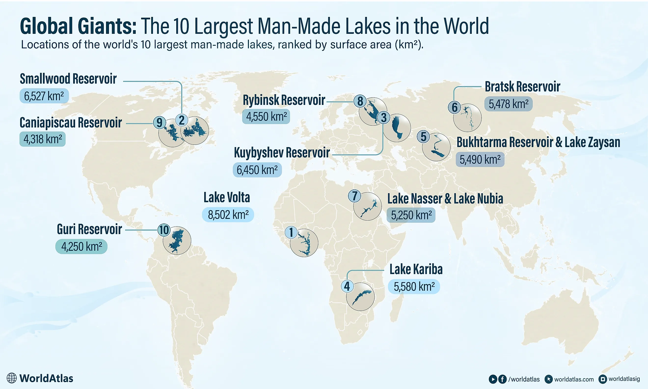
This ranking measures the world's largest man-made lakes by one thing: surface area at full operating level, the amount of ground each reservoir covers. By that measure, Lake Volta comes first, spreading across an expanse of Ghana larger than some countries. Surface area is not the same as volume, so a lake that ranks high here does not necessarily hold the most water. Lake Kariba, on the border of Zambia and Zimbabwe, is the clearest example. It sits lower on this list than Lake Volta but holds far more water. That is because it fills a deep gorge rather than a broad, shallow valley. The flooded terrain also shapes how each lake is contained. Canada's two entries, Smallwood and Caniapiscau, sit behind dozens of dikes across low plateau ground instead of one wall in a canyon. Every entry below is ordered by surface area alone.
The 10 Largest Man-Made Lakes in the World
| Rank | Lake and Country | Surface Area |
|---|---|---|
| 1 | Lake Volta (Ghana) | 8,502 km² (3,283 mi²) |
| 2 | Smallwood Reservoir (Canada) | 6,527 km² (2,520 mi²) |
| 3 | Kuybyshev Reservoir (Russia) | 6,450 km² (2,490 mi²) |
| 4 | Lake Kariba (Zambia and Zimbabwe) | 5,580 km² (2,154 mi²) |
| 5 | Bukhtarma Reservoir and Lake Zaysan (Kazakhstan) | 5,490 km² (2,120 mi²) |
| 6 | Bratsk Reservoir (Russia) | 5,478 km² (2,115 mi²) |
| 7 | Lake Nasser and Lake Nubia (Egypt and Sudan) | 5,250 km² (2,027 mi²) |
| 8 | Rybinsk Reservoir (Russia) | 4,550 km² (1,757 mi²) |
| 9 | Caniapiscau Reservoir (Canada) | 4,318 km² (1,667 mi²) |
| 10 | Guri Reservoir (Venezuela) | 4,250 km² (1,641 mi²) |
1. Lake Volta - Ghana

No reservoir on Earth covers more ground than Lake Volta, which floods 8,502 km² (3,283 mi²) of southeastern Ghana. It formed after the Akosombo Dam closed across the Volta River in the 1960s, backing water into the valleys of the Black Volta, White Volta, and Oti rivers. The result is not a simple oval lake but a long, branching outline with countless inlets, islands, and narrow passages. The reservoir was built mainly to generate hydroelectricity, though it also became an important route for ferries and cargo vessels in a country where some lakeside communities remain hard to reach by road. Fishing supports settlements along the shore. Filling the valley also permanently altered the landscape and forced the relocation of tens of thousands of residents.
2. Smallwood Reservoir - Canada

Unlike almost every other lake on this list, Smallwood is not held back by a single dominant dam. Instead, 88 dikes stretch across low points in the Labrador Plateau, containing water that would otherwise escape into neighboring drainage basins. The reservoir spreads over roughly 6,527 km² (2,520 mi²) of the Labrador interior and incorporates former lakes, wetlands, and river channels, giving it a broken, island-filled shape that mirrors the terrain beneath it. Its stored water feeds the Churchill Falls Generating Station, one of Canada's largest hydroelectric facilities. The setting is remote, cold, and sparsely populated, so the reservoir looks nothing like artificial lakes ringed by farms or cities. Its immense area came from flooding broad, relatively shallow uplands rather than one deep river gorge.
3. Kuybyshev Reservoir - Russia

Stretching for hundreds of kilometers along the middle Volga and lower Kama rivers, Kuybyshev Reservoir is the largest reservoir in Europe and the third largest in the world by surface area. The water grows so broad near cities such as Kazan and Ulyanovsk that residents call it the Kuybyshev Sea. It filled between 1955 and 1957 after construction of the Zhiguli Hydroelectric Station, forming a major link in the Volga cascade of dams and navigation routes. The reservoir supports shipping, power generation, water supply, and fisheries, but its formation also submerged settlements and productive floodplain land. Waves, seasonal ice, and long open-water crossings give it the behavior of an inland sea rather than a conventional river reservoir.
4. Lake Kariba - Zambia and Zimbabwe

Along the Zambezi Valley between Zambia and Zimbabwe lies Lake Kariba, which holds the largest volume of stored water of any reservoir on the planet even though several rank above it by surface area. The lake began filling after Kariba Dam was completed in the late 1950s, turning a river gorge into a long border lake scattered with drowned trees and islands. Hydroelectric stations on both sides of the dam supply electricity to the two countries, so changing water levels become a matter of national importance. Construction displaced Tonga communities from the valley, while the rescue effort known as Operation Noah lifted thousands of animals clear of the rising water. Kariba now supports commercial fishing, tourism, and wildlife areas, though recurring droughts expose the risk of relying so heavily on its hydropower.
5. Bukhtarma Reservoir and Lake Zaysan - Kazakhstan

The Bukhtarma system on the Irtysh River in eastern Kazakhstan is only partly artificial, which sets it apart from the others here. Lake Zaysan existed naturally long before the Bukhtarma Dam was built. The dam raised the lake's level and joined it to newly flooded river valleys, producing a hybrid that combined about 5,490 km² (2,120 mi²) of expanded natural lake and reservoir. The system runs for more than 500 kilometers (310 miles) through a landscape framed by the Altai and other mountain ranges. It regulates the Irtysh, generates hydroelectricity, and supports navigation and fishing across the region. Broad bays fill former tributary valleys, while narrower reaches preserve the original river's course. Because of this mixed origin, Bukhtarma is sometimes left out of rankings limited to entirely artificial lakes.
6. Bratsk Reservoir - Russia

On the Angara River in Russia's Irkutsk region, Bratsk Reservoir combines a surface area of roughly 5,478 km² (2,115 mi²) with exceptional depth and storage capacity. The flooded valleys of the Angara and Oka rivers form two long arms, creating thousands of kilometers of irregular shoreline. Bratsk Dam and its power station became major symbols of Soviet industrial ambition, powering energy-intensive industries across Siberia. The reservoir also serves navigation, water supply, fishing, and timber transport. Its construction carried a heavy human cost as villages, farmland, and cultural sites vanished beneath the rising water. That upheaval entered Russian literature, most famously through Valentin Rasputin's novel Farewell to Matyora, which portrays a community facing removal before its island is flooded.
7. Lake Nasser and Lake Nubia - Egypt and Sudan

Behind the Aswan High Dam, a single reservoir stretches for about 500 kilometers (310 miles) along the Nile across two countries. Its Egyptian portion is known as Lake Nasser, while the Sudanese section is called Lake Nubia, and together they cover roughly 5,250 km² (2,027 mi²) at the usual operating level. The reservoir stores Nile water for year-round irrigation, limits damaging floods, and supplies the dam's hydroelectric station. Narrow arms reach into former desert valleys, setting blue water against bare rock. Construction forced the large-scale resettlement of Nubian communities and threatened major archaeological sites. An international campaign moved monuments, including the temples of Abu Simbel, to higher ground, tying the lake to one of the most ambitious heritage-rescue efforts ever attempted.
8. Rybinsk Reservoir - Russia

When it filled during the 1940s, Rybinsk was the largest artificial lake in the world. It sits in the upper Volga basin where the Volga, Sheksna, and Mologa rivers meet, covering about 4,550 km² (1,757 mi²). Rather than filling a steep valley, it inundated a wide, low-lying plain, producing a broad but relatively shallow body of water. Strong winds raise rough waves across its open surface, which is how it earned the nickname the Rybinsk Sea. The reservoir improved navigation between the Volga and Baltic waterways and still generates hydroelectric power, but its creation erased towns, villages, forests, and farmland. The historic town of Mologa was among the places submerged. Rybinsk remains both a major engineering achievement and a stark example of the social cost of Soviet river development.
9. Caniapiscau Reservoir - Canada

Built as part of the James Bay hydroelectric project, Caniapiscau is contained by two main dams and 43 dikes rather than a single barrier. It covers more than 4,300 km² (1,660 mi²) in the remote northern interior of Quebec, absorbing several existing lakes to leave a maze of peninsulas, channels, and hundreds of islands. The reservoir functions mainly as a vast storage basin for the La Grande power complex, banking water through wet periods for release when electricity demand climbs, particularly in the Quebec winter. The project also redirected much of the upper Caniapiscau River, pulling its flow off the original northward route toward Ungava Bay and into the westward-flowing La Grande system. The scale is hard to grasp from the ground, since the surrounding taiga holds few roads, towns, or familiar landmarks.
10. Guri Reservoir - Venezuela

Closing the list is Guri Reservoir, also called Lake Guri, which follows the Caroní River across roughly 4,250 km² (1,641 mi²) of southeastern Venezuela at its normal maximum operating level. It was created in stages as the Guri Dam and Simón Bolívar Hydroelectric Plant expanded from the 1960s onward. The rising water flooded a rolling tropical landscape, leaving former hilltops as islands of varying size. Those isolated forest fragments later became valuable study sites for scientists examining how habitat loss reshapes animal communities. The reservoir's main purpose, though, is electricity generation. Guri has long formed the backbone of Venezuela's hydropower system, so drought and low water levels can have consequences far beyond the lake itself. Its flooded basin shows both the extraordinary generating potential of the Caroní River and the environmental risks that come with large-scale dam projects.
The Lasting Impact of the World's Largest Reservoirs
The world's largest man-made lakes store water, produce electricity, support shipping, and help countries manage rivers that once flooded unpredictably. In several cases, they became central to national power systems and regional economies. Those benefits came with lasting costs. Towns, farmland, forests, archaeological sites, and entire communities were displaced as the water rose.