Colorado's 12 Most Laid-Back Towns
Colorado's laid-back towns are not all sleepy mountain villages. In Salida, kayakers ride the Arkansas River waves just steps from downtown galleries. Paonia's orchards, vineyards and farm stands give the North Fork Valley a distinctly rural character. Crested Butte draws visitors with its wildflower meadows and colorful Elk Avenue, and Silverton's old mining streets retain the feel of a high-altitude frontier town. These 12 Colorado towns each have their own way of making a mountain getaway feel unhurried.
Salida

Salida is an appealing choice for travelers who want mountain scenery without the atmosphere of a major ski resort. The town sits in central Colorado's Arkansas River Valley, about 100 miles southwest of Colorado Springs via US Highway 24 and US Highway 285. The Sawatch Range rises to the west, while the Arkansas River passes directly through downtown.
Salida's historic district is a natural place to spend an afternoon. F Street contains galleries, independent shops, and restored commercial buildings dating largely to the late 19th and early 20th centuries. The nearby SteamPlant Event Center, a former power plant, hosts concerts, theatrical performances, and community events.
Outdoor recreation is equally accessible. At the Salida Whitewater Park, visitors can watch kayakers tackle engineered river waves or enjoy the Arkansas River corridor. Experienced paddlers can arrange rafting trips through nearby Browns Canyon National Monument, which protects a stretch of granite canyon along the river.
For a slower afternoon, the Salida Hot Springs Aquatic Center has indoor pools fed by natural mineral water. Travelers who prefer a view from above can head toward Tenderfoot Mountain, the hill marked by a large letter S overlooking town. Afterward, dinner at Amicas Pizza & Microbrewery on F Street makes a convenient end to a day spent mostly within a few blocks of downtown.
Buena Vista

A little south of Leadville and east of the Collegiate Peaks, Buena Vista's name is pronounced BYOO-nuh VIS-tuh, and its setting along the upper Arkansas River makes it a natural base for outdoor activities. US Highway 24 runs through town, connecting it with Leadville to the north and the US 285 corridor farther south.
The river is central to daily life here. Buena Vista's River Park has access points for kayaking, paddleboarding, and river surfing, while commercial outfitters arrange whitewater rafting trips through Browns Canyon. Visitors who would rather keep their feet dry can sit beside the water and watch the Collegiate Peaks rise beyond the valley.
A few miles west of town, Cottonwood Hot Springs has mineral pools surrounded by forested mountain terrain. Farther south, near Nathrop, Mount Princeton Hot Springs Resort has additional pools and facilities for a longer visit.
History enthusiasts can drive approximately 20 miles west of Buena Vista along Chalk Creek Road to St. Elmo, one of Colorado's best-preserved ghost towns. Its weathered wooden buildings recall the mining communities that once occupied the surrounding mountains. Back in town, South Main, a riverside neighborhood with restaurants and recreation facilities, is a good place to grab dinner at Eddyline Brewery after a day outdoors.
Crested Butte

Crested Butte sits in the upper Gunnison Valley in west-central Colorado. The town lies north of Gunnison along State Highway 135, with the Elk Mountains rising around the valley. Its historic center retains colorful storefronts and older commercial buildings, while the surrounding landscape draws hikers, cyclists, and skiers.
Elk Avenue is the main street and the best place to get a feel for local life. Cafes, galleries, outdoor shops, and restaurants line the road, making it easy to spend an hour browsing without planning a full itinerary. The Crested Butte Mountain Heritage Museum provides additional context on the area's mining, ranching, and skiing history.
In summer, the hillsides around town are known for wildflowers. Trails near the Snodgrass Mountain area and other nearby public lands give hikers access to meadows and views of the surrounding peaks. Mountain bikers have an extensive network of singletrack routes, although riders should choose trails according to their experience and current conditions.
For a scenic drive, Kebler Pass west of town is particularly popular in late summer and fall, when large aspen groves turn gold. The road connects the Crested Butte area with the North Fork Valley near Paonia, but it is seasonal and typically closes during winter. Travelers should check road conditions before relying on it as a through route.
Ouray

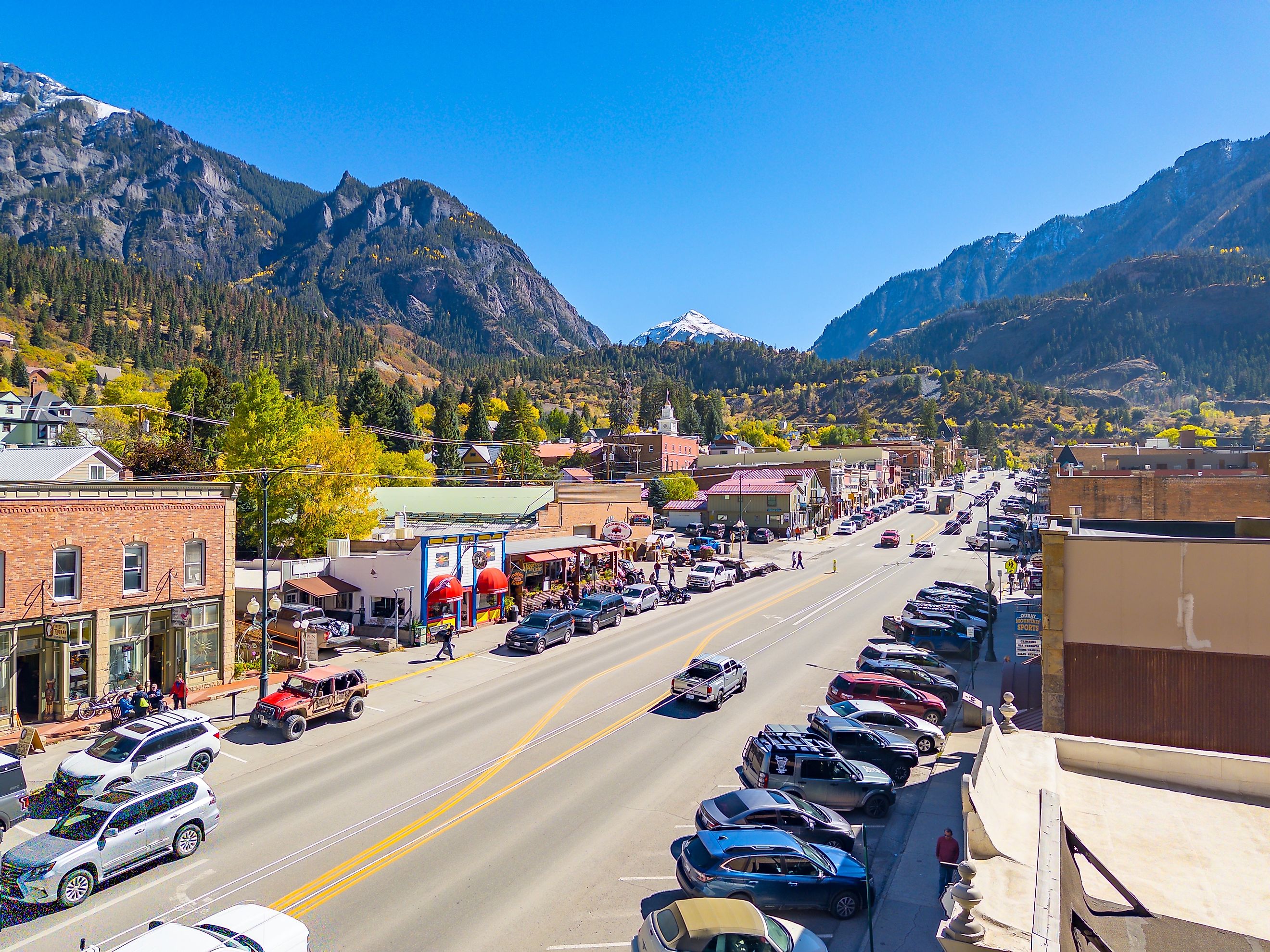
Known for its steep mountain setting and historic downtown, Ouray occupies a narrow valley in the San Juan Mountains of southwestern Colorado, about 37 miles south of Montrose on US Highway 550. The town's compact layout makes it easy to reach restaurants, shops, and several outdoor attractions without driving far.
The most dramatic nearby natural attraction is Box Cañon Falls Park, where Canyon Creek plunges into a narrow rock gorge. Short paths lead to viewpoints and a high bridge, while additional trails climb above the canyon. The park is close enough to downtown for a short outing, although its stairs and steeper paths may require extra care.
Ouray's hot springs are another reason to linger. The Ouray Hot Springs Pool has several temperature-controlled pools with mountain views, making it a practical stop after hiking. For a more active afternoon, the Ouray Perimeter Trail circles the town through varied terrain, passing waterfalls, bridges, and overlooks. The full route is about 5.6 miles, with significant elevation gain and loss.
The historic district along Main Street has brick storefronts, restaurants, and buildings that reflect the town's mining past. A drive north toward Ridgway reveals broad valley views, while the famous Million Dollar Highway continues south from Ouray toward Silverton through high mountain passes. The southern route is spectacular but demands attentive driving, especially during snow, ice, or poor visibility.
Silverton

Silverton is one of Colorado's tiniest mountain communities. It sits at more than 9,000 feet in the San Juan Mountains, roughly 23 miles south of Ouray along US Highway 550. Formerly a mining boomtown, Silverton retains a historic district of wooden storefronts, hotels, and commercial buildings.
The town center is compact enough to explore on foot. Blair Street and the surrounding blocks contain historic businesses and places to eat, while the San Juan County Historical Society's mining heritage exhibits explain the region's silver and gold rushes. Visitors interested in industrial history can also take a guided tour at the Old Hundred Gold Mine, where demonstrations and underground access illustrate the work once carried out in the mountains.
Another major attraction is the Durango & Silverton Narrow Gauge Railroad. The historic train travels through the Animas River canyon between Durango and Silverton during its seasonal Silverton service. The ride takes much of a day as a round trip from Durango, but visitors already staying in Silverton can enjoy the depot and see the train arrive.
For outdoor enthusiasts, the Alpine Loop connects remote mountain roads and former mining settlements, though much of the route requires a high-clearance four-wheel-drive vehicle. Molas Lake, south of town on US 550, is a good destination for mountain views, camping, and fishing. Winter brings opportunities for skiing at nearby Kendall Mountain and Silverton Mountain, the latter known for challenging terrain suited to advanced skiers.
Paonia

For a change from Colorado's high-altitude resort communities, head to Paonia in the North Fork Valley. It lies east of Delta and northwest of Gunnison, reached by State Highway 133 and State Highway 92. Orchards, vineyards, farms, and the surrounding mesas give the area a distinctly agricultural character.
Grand Avenue is the center of town, with local businesses, public art, and places to eat. Paonia's creative community has galleries and murals, while the historic Paradise Theatre serves as a venue for films and community events. These attractions make downtown a useful starting point before heading into the countryside.
The area's orchards are among its main draws. Depending on the season, farm stands sell cherries, peaches, apples, pears, and other locally grown produce. Nearby wineries and cideries make the North Fork Valley a good destination for travelers who want to spend an afternoon tasting regional products rather than following a packed sightseeing schedule.
Outdoor options are close by, too. Paonia State Park lies about 16 miles northeast of town along State Highway 133 and has a reservoir for boating, fishing, and camping. The surrounding Ragged Mountains provide a backdrop for drives and hikes, while the valley's rural roads pass working farms and open landscapes. Visit during harvest season for fruit stands and vineyard activity, or in summer for access to the reservoir and surrounding trails.
Carbondale

Carbondale is about 30 miles northwest of Aspen along State Highway 82. Mount Sopris rises to the south of town, providing a familiar landmark across the Roaring Fork Valley. Carbondale has a working-town feel, with a downtown that serves local residents as much as visitors passing through the region.
The historic commercial district is a good place to spend a morning. Independent restaurants, galleries, and shops line Main Street, and the town's creative district highlights local artists and makers. The Thompson House Museum preserves the story of an early local family and provides a glimpse into the community's past.
Outdoor activities are easy to reach. The Crystal River runs southwest of town, while nearby trails accommodate hiking, cycling, and fishing. Spring Gulch, a short drive away, is known for cross-country skiing and snowshoeing during winter. Mount Sopris is a prominent hiking objective, but its demanding routes require preparation and are best left to experienced hikers.
For a more leisurely outing, the Rio Grande Trail follows the Roaring Fork River corridor and connects communities in the valley. It is popular with cyclists and walkers who want to cover a stretch of the region without driving between every stop. Carbondale's restaurants and cafes make it easy to return to town for dinner before continuing toward Glenwood Springs or Aspen the following day.
Estes Park

Estes Park sits about 65 miles northwest of Denver, reached most directly via US Highway 36. The town serves as the eastern gateway to Rocky Mountain National Park, making it a convenient base for mountain scenery and wildlife viewing. Its popularity means summer weekends can be busy, but the compact downtown and surrounding open spaces still allow for a flexible visit.
Elkhorn Avenue is the main commercial street, lined with restaurants, candy shops, galleries, and outdoor outfitters. The Estes Park Riverwalk runs beside parts of the Big Thompson River and Fall River, connecting downtown businesses with paths along the water. It is a good choice for a short outing between meals or before heading into the national park.
For mountain scenery, Rocky Mountain National Park has alpine lakes, forest trails, and high-elevation roads. The Bear Lake area is particularly popular, with several hiking routes beginning near the lake. Timed-entry reservations may be required during parts of the busy season, so check current park rules before driving in.
Closer to town, Lake Estes has a 3.75-mile trail around the shoreline, along with seasonal kayak, paddleboard, and boat rentals. The Stanley Hotel, a historic property overlooking the valley, is another well-known stop for architecture and local history. Wildlife sightings are common around the Estes Park area, especially elk in meadows and open spaces, so keep a respectful distance and avoid blocking roads when animals appear.
Manitou Springs

At the western edge of Colorado Springs, Manitou Springs lies at the foot of Pikes Peak, roughly 75 miles south of Denver by road. Its historic core, mineral springs, and access to red-rock scenery make it a useful destination for travelers who want mountain activities without venturing deep into the Rockies.
Manitou Avenue runs through the heart of downtown and is lined with independent shops, restaurants, art galleries, and historic buildings. One of the town's most distinctive activities is a self-guided tour of its naturally carbonated mineral springs. Public springs are spread around the commercial district, each with its own mineral composition and taste.
The Pikes Peak Cog Railway departs from Manitou Springs and climbs toward the summit of the 14,115-foot mountain. The journey gives visitors a way to experience high-altitude scenery without undertaking a strenuous hike. Reservations are recommended, and conditions at the summit can be much colder than in town.
Hikers may prefer the Manitou Incline, a steep ascent following the route of a former funicular railway. It gains roughly 2,000 feet in less than a mile and requires a timed reservation, so it is not a casual walk. For a gentler outdoor outing, Garden of the Gods lies about 10 minutes east by car, with paved paths winding among towering red sandstone formations. Afterward, the Miramont Castle Museum provides a look at an unusual historic mansion within walking distance of downtown.
Trinidad

Trinidad is located in southern Colorado, near the New Mexico border. Interstate 25 runs directly past town, making it an accessible stop between Denver and Santa Fe. The Sangre de Cristo foothills rise to the west, while the surrounding landscape transitions toward the plains farther east.
Trinidad's historic downtown is a strong reason to stop. North Commercial Street has preserved buildings that reflect the town's role along the Santa Fe Trail and its later coal-mining history. The El Corazón de Trinidad National Historic District includes historic homes and commercial architecture, while the Bloom Mansion and Baca House offer insight into the area's early settlement.
For a change of pace, Fishers Peak State Park protects a large area of rugged terrain just south of town. Its trails climb through foothills toward the prominent mesa, with routes suited to hikers and mountain bikers. Visitors should check trail conditions and access information before setting out, since distances and elevation gain vary.
Trinidad Lake State Park, west of downtown, is another option for a half-day outdoors. The reservoir attracts anglers, boaters, and campers, while shoreline paths give visitors views of the surrounding hills. Back in town, the local arts scene includes galleries, public art, and creative spaces that occupy historic buildings. Trinidad's combination of architecture and outdoor access makes it especially appealing to travelers driving through the southern part of the state.
Georgetown

Georgetown is located roughly 45 miles west of Denver on Interstate 70. Its Victorian buildings and mining-era history make it a rewarding stop in the Rocky Mountains, particularly for visitors who want a mountain getaway without committing to a longer trip into western Colorado.
Sixth Street is the town's historic main corridor, with preserved storefronts, local businesses, and buildings dating to the silver-mining boom. The Hotel de Paris Museum recreates the atmosphere of a 19th-century French hotel, while the Hamill House Museum documents the lives of a prominent mining-era family. Both help explain why Georgetown developed into an important community during Colorado's mining period.
The Georgetown Loop Railroad is one of the area's signature attractions. The narrow-gauge train travels through a mountain canyon toward nearby Silver Plume, crossing the high Devil's Gate Bridge and passing former mining sites. It is a convenient option for visitors who want mountain scenery without a long hike.
For a scenic drive, Guanella Pass begins at the southern end of town and climbs toward alpine terrain before descending to Grant. The 22-mile byway has access to hiking areas and mountain viewpoints, with colorful aspen groves in fall. The upper road is seasonal, and some sections close during winter, so check conditions before setting out. Georgetown's compact center makes it easy to return from the drive for a meal before heading back to I-70.
Leadville

At an elevation of about 10,150 feet, Leadville is one of the highest incorporated cities in the United States. It sits in central Colorado, northwest of Buena Vista and south of Vail. US Highway 24 passes through town, while US Highway 91 connects it with Interstate 70 to the north.
Leadville's history is visible along Harrison Avenue, where restored commercial buildings recall the town's silver-mining heyday. The National Mining Hall of Fame and Museum explores the people, machinery, and technology behind the industry that shaped Colorado's development. Visitors can also learn about the town's past at the Tabor Opera House, a historic performance venue that reflects Leadville's former wealth.
Outdoor activities are close at hand. Turquoise Lake, west of town, has a scenic road, picnic areas, campgrounds, and access to fishing and boating. Its forested shoreline and mountain views make it a good place to spend several hours without planning a demanding excursion.
For a more ambitious outing, Leadville is surrounded by some of Colorado's highest peaks, including Mount Elbert and Mount Massive. Both require careful planning, acclimatization, and suitable equipment, particularly given the elevation. Travelers seeking an easier activity can take a scenic drive along nearby mountain roads or visit during summer for local events and historic walking tours. In winter, snow-covered trails and nearby ski areas add seasonal options, though the town's high elevation can bring rapidly changing weather.
Colorado's most appealing laid-back towns are spread across very different landscapes. Salida and Buena Vista revolve around the Arkansas River, while Ouray and Silverton occupy the rugged San Juan Mountains. Paonia brings visitors into an agricultural valley, Georgetown preserves a chapter of mining history near the Front Range, and Manitou Springs pairs historic streets with easy access to Pikes Peak.
The best choice depends on the kind of trip you have in mind. For galleries and independent businesses, Salida and Crested Butte are strong candidates. For hot springs, consider Ouray or Buena Vista. Travelers interested in historic railways can head to Silverton or Georgetown, while Leadville and Estes Park put high mountain scenery within easy reach of town. Wherever you go, checking seasonal road closures, trail conditions, and attraction schedules ahead of time will leave more room to enjoy Colorado at your own pace.