7 Most Scenic Drives in The Rockies
The Rocky Mountains span from near the Mexican border to northern Canada, and the numerous scenic byways crisscrossing them often reveal the chain’s most distinctive landscapes and histories, usually without you ever having to leave your car! These remarkable routes intersect alpine passes, river valleys, and national parks, linking everything from sleepy mining towns to bustling cities with remote wilderness areas and a wide range of cultural landmarks.
Each of the drives we will be highlighting here will also provide you with direct access to renowned hiking trails, geological wonders, and preserved settlement sites dating back to the Wild West era. From Alberta down to the American Southwest, these notable highways of the Rockies present a plethora of opportunities to explore North America's most incredible high-rising scenery.
Top of the Rockies, Colorado

Aptly named "The Top of the Rockies," this official byway spans approximately 83 miles through the heart of Colorado, connecting towns such as Minturn, Leadville, and Aspen via U.S. 24 and State Highway 82. This route can be traced in several ways, crossing the Continental Divide twice at Tennessee Pass and Independence Pass. It notably stays above 9,000 feet for much of the journey, making it one of the most lofty roadways in the United States, too, where you will likely catch sight of peaks like Mount Elbert and Mount Massive.
Leadville, once a major mining center, now houses some must-see museums, including the National Mining Hall of Fame and Museum, as well as a collection of picturesque Victorian-era architecture and access to the Mineral Belt Trail. Then, near Twin Lakes, a handful of scenic pullouts overlook glacial valleys and the surrounding Sawatch Range. Moreover, Independence Pass, open seasonally, is where many of the truly panoramic views can be found, along with popular trailheads leading to alpine tundra terrain before descending into the Roaring Fork Valley and Aspen.
Along the route are numerous front-country campgrounds, giving you the ability to travel it over multiple days during the warmer months, while fall brings notable color throughout the abundant aspen groves all across the way. Also, keep your eyes peeled for the wildlife, which is especially common at higher elevations.
Sawtooth Scenic Byway, Idaho

The Sawtooth Scenic Byway runs for about 115 miles through central Idaho, following State Highway 75 from Shoshone to Stanley. The route crosses varied terrain, from the lava fields of the Snake River Plain to the jagged peaks of the Sawtooth Range.
South of Ketchum, the byway passes through the Sawtooth National Recreation Area, one of the most photographed landscapes in the state. Ketchum and Sun Valley also form what many consider the byway’s main tourist hub, offering access to dozens of popular trails, skiable terrain, and historic sites tied to early tourism and even Ernest Hemingway’s final years. Having died at his home in Ketchum, this spot has since been added to the National Register of Historic Places.
North of Ketchum, Galena Summit rises to nearly 8,700 feet, with overlooks of the Sawtooth Valley and Salmon River headwaters. This mountainous terrain also comes with a number of great local ski resorts, like the Sun Valley Resort, or further north, the Galena Lodge.
Moving on to Stanley, campgrounds and more trailheads line the river corridor, leading to alpine lakes such as Redfish and Sawtooth. Be sure to keep an eye open for the interpretive signs along the byway that highlight the region's glacial geology, ranching history, and the creation of some of Idaho’s earliest conservation areas.
Enchanted Circle Scenic Byway, New Mexico

The Enchanted Circle Scenic Byway loops for about 85 miles through northern New Mexico, connecting the towns of Taos, Questa, Red River, Eagle Nest, and Angel Fire together for a visually beautiful and culturally rich excursion. It also notably circles Wheeler Peak, the state’s highest summit at over 13,160 feet, and perfectly showcases the mountains, valley, and high desert terrain of the far southern reaches of the Rockies. This drive is especially scenic in late September, when the aspen forests surrounding Bobcat Pass turn bright gold.
To start, Taos serves as the byway’s clear cultural anchor, with the Taos Pueblo and several art museums exemplifying centuries of Indigenous and Hispanic heritage in the area. North of town, the road climbs toward the Carson National Forest and passes old mining areas near Red River. And for a more active outing, stop by Eagle Nest Lake State Park if you have a boat (or if you simply want to spend some time by the water), as boat launches and space for picturesque vistas across to the mountains are abundant. Moreover, the nearby community of Angel Fire offers more robust hiking, mountain biking, and winter trails.
Learn more about the must-visit route at the various educational pull-offs that detail the area’s human history and high-country ecology, particularly the Enchanted Circle Gateway Museum & Visitor Center in Eagle Nest.
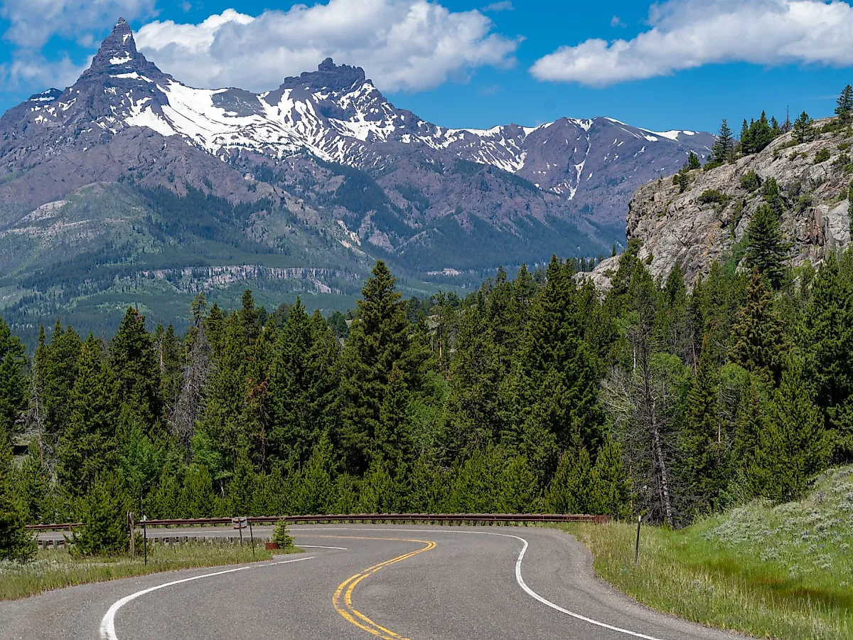
Beartooth Highway, Montana & Wyoming

The Beartooth Highway runs for close to 70 miles between Red Lodge, Montana, and the northeast entrance of Yellowstone National Park in Wyoming. Designated an "All-American Road," it crosses the Beartooth Plateau at elevations exceeding 10,900 feet, making it one of the highest paved highways in the United States. Regardless of where you end your drive, it fantastically showcases Montana's high-rising tundras, crystal-clear glacial lakes, and the rugged, snowcapped peaks of the Absaroka-Beartooth Wilderness.
Assuming you start in Red Lodge, the road ascends quickly through switchbacks to Rock Creek Vista Point, which overlooks a series of deep valleys and snowfields that stick around well into summer. Beyond this summit, several pullouts provide access to short walking trails and high-elevation lakes such as Gardner and Beartooth.
For a historic touch, near Cooke City, remnants of early mining operations appear along the roadside, connecting this wild and remote landscape to the area's original function as a treasure trove of natural resources in the hungry, early days of the country.
Understand that the Beartooth Highway is open seasonally, typically from late May to October, and is noted for unpredictable mountain weather and sweeping, unobstructed views across the northern Rockies. Be sure to have appropriate tires for the season before embarking on this gem of an outdoor adventure!
Alpine Loop Scenic Byway, Utah

The Alpine Loop Scenic Byway is a shorter route for this list, passing only about 20 miles of Highway 92 through Utah’s Wasatch Range, hooking American Fork Canyon to Provo Canyon. This narrow, winding road climbs thousands of feet, passing dense forests, sheer cliffs, and high meadows within Uinta National Forest. It is typically open from late May through October due to snow at higher elevations, with mid-late summer being a great time to catch the height of the wildflower bloom.
Key stops include Timpanogos Cave National Monument, where guided tours explore a system of marble caverns filled with formations. The road continues past viewpoints of Mount Timpanogos and Cascade Springs, a clear-water system fed by underground sources. If you're down for a walk, several trailheads, including those for the Timpooneke and Aspen Grove trails, lead to more alpine basins and quieter summits.
Like many of the drives mentioned here, autumn draws heavy crowds to the route's ample stands of aspen groves, which brilliantly change color before shedding for the winter. Sitting just outside Salt Lake City, perhaps plan for a weekday outing to avoid potential traffic jams filled with other fellow leaf peepers.
Icefields Parkway, Alberta

The Icefields Parkway extends for about 144 miles between Lake Louise and Jasper National Park, running through the heart of the Canadian Rockies and passing by some of the chain's most iconic landmarks north of the border. It connects Banff and Jasper, following the valleys of the Bow and Athabasca Rivers, and is recognized for its concentration of glaciers, turquoise lakes, and accessible alpine terrain for all to appreciate.
Major stops include Bow Lake, Peyto Lake, and Mistaya Canyon near the southern end. The Columbia Icefield, however, is one of the largest accumulations of ice south of the Arctic Circle and is the central highlight for most visitors, featuring its own Icefield Centre with exhibits and even tours directly onto the Athabasca Glacier itself.
Farther north, Sunwapta Falls and Athabasca Falls each contain relatively flat, easy-to-navigate trails and viewing platforms, perfect destinations in the summer or fall. Wildlife such as mountain goats, bears, and elk are also frequently seen in these areas.
All this in mind, the parkway’s numerous overlooks and maintained trails make it Canada's most studied and photographed mountain corridor. If you have the time (4-5 extra hours, to be more precise), it also doubles as a truly spectacular way to travel between Calgary and Edmonton versus the traditional 3-hour direct route through Red Deer.
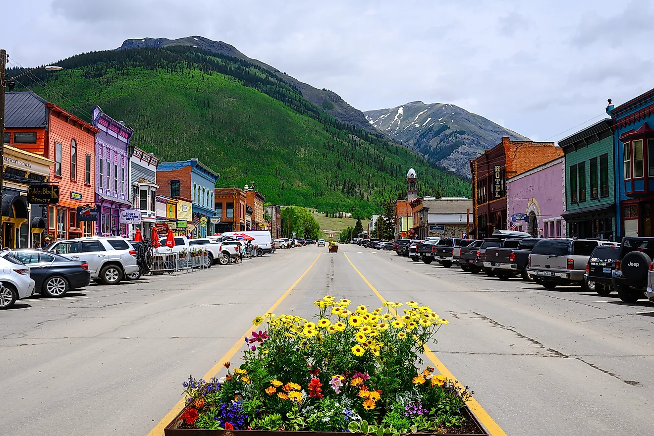
San Juan Skyway, Colorado

The San Juan Skyway Scenic Byway loops for about 230 miles through the southwest corner of the state, with major towns and cities like Durango, Silverton, Ouray, Telluride, Cortez, and Dolores to be explored along this lengthy route. Here, multiple mountain passes, including Red Mountain Pass and Lizard Head Pass, reach elevations over 11,000 feet, and they traverse a diversity of landscapes covering snowcapped peaks, old-timey towns, and deep, lush river valleys, each of which exemplifies the beauty and history of the San Juan Mountains.
Along the drive, fan favorite stops include the historic Durango & Silverton Narrow Gauge Railroad, the hot springs in Ouray, and the preserved mining sites and ski resorts near Silverton. Telluride, set in a narrow box canyon, may be the most visually striking of the lot, with towering cliffs on each side and a downtown that feels taken right out of a Western film. Summer in the area also brings wildflower displays, while autumn highlights the massive groves of aspens that line the high passes.
On the other side, near Cortez, the route then passes close to Mesa Verde National Park, known for its Ancestral Puebloan cliff dwellings. Other ancient structures and archaeological sites dating back hundreds of years can be explored here, giving you a window into the people who called Colorado home long before European settlement.
See The Wonders of the Rockies on the Road
The many awe-inspiring byways through the Rockies form a continuous network across some of North America’s most remarkable terrain. Each road we have highlighted above takes you close to a different layer of this immense mountain corridor, cutting through the heart of the continent and linking protected lands, diverse cultures, and longstanding settlements that define the region’s identity in both Canada and the United States. Whether you're crossing Banff National Park or tracing the headwaters of the Colorado River, you really can't go wrong with a road trip along any of these routes.