What Countries Border Benin?
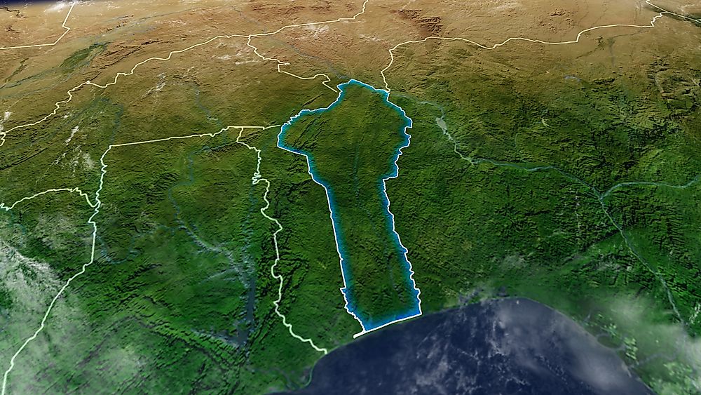
Benin, previously known as Dahomey, is an independent French-speaking state in West Africa. Benin is bounded by Niger, Burkina Faso, Nigeria, and Togo. The country extends from the Atlantic Ocean to the Niger River (a distance of about 435 miles). Benin occupies an area of approximately 44,310 sq miles and has over 10,872,298 residents. Majority of the locals reside in the Bay of Benin which is on the northern part of the Atlantic Ocean. Porto-Novo is the nation’s economic capital and largest city. It is a tropical state which depends on agriculture with a considerable part of their income coming from subsistence farming. Other than French, their official language, the people converse in numerous indigenous dialects like Yoruba and Fon. The most significant religious faction in the country is the Roman Catholicism followed by other smaller ones like Protestantism, Vodun, and Islam.
Countries Bordering Benin
1) Togo
Togo is a sovereign West African nation which is surrounded by Burkina Faso, Benin, and Ghana. Togo stretches to the Gulf of Guinea, where Lome, its capital is situated. It is one of the smallest African nations which occupy an area of about 22,008 sq miles with over 7.6 million residents. During the nineteenth century, Togo and the surrounding area were known as the Slave Coast. Togo became a German protectorate in 1884, and it was renamed Togoland. It was transferred to the French after the Second World War. Togo became an independent state in 1960.
The Togo-Benin boundary is about 405 miles long. River Mono which originates from the border of Benin and Sokode serves as an international boundary between Benin and Togo before it drains into the Benin Bay. The highest point in Benin is the 2,159 ft high Mont Sokbaro which is on the Togo-Benin border. Another river which forms part of this border is the Oti River whose headwaters are located in Burkina Faso. One of the main border crossings between Togo and Benin is in the town of Boukombe. Boukombe is a small town in Benin which is on its boundary with Togo. Boukombe is famous for its pipe making tradition, whipping ceremony and market.
2) Nigeria
Nigeria is a West African federal state which is bordered to the west by Benin, Niger to the north, and Cameroon and Chad to the east. The Nigerian coast, which is on the southern side of the country, is in the Gulf of Guinea. It is a democratic secular nation which has thirty-six states with its capital being Abuja. Nigeria is the thirty-second largest state in the world which occupies an area of about 356,669 sq miles. It is the seventh most populous state globally and most populated in Africa with over 190 million Nigerians. Nigeria has been home to numerous tribal nations and kingdoms for years now. Present-Day Nigeria is the outcome of the British colonial rule which started during the nineteenth century.
The Nigeria-Benin boundary is the 503-mile long border which separates the two countries. River Okpara forms a significant part of the boundary. River Okpara rises from the department of Borgou in Benin and flows southwardly before becoming the boundary between Nigeria and Benin and finally draining into River Oueme. Numerous villages which are on the river Okpara’s banks are still being disputed between the two countries. The Nigerian-Benin boundary has several crossways with the famous one being the A7 highway which stretches from Ilorin, Nigeria though Kaiama and Kishi into Benin. The crossing point at Seme Border is the one used mostly by immigrants and smugglers into and out of Nigeria. The border post at Seme is poorly organized.
3) Burkina Faso
Burkina Faso is a West African landlocked state which occupies an area of about 105,900 sq miles. The country is surrounded by Niger, Ivory Coast, Benin, Ghana, and Togo. The population of the country was estimated to be over 20,107,509 in 2017. The official business and government language of Burkina Faso is French. Previously known as the Republic of Upper Volta, President Thomas Sankara renamed it to Burkina Faso on August 4, 1984. Upper Volta was a self-governing colony which was formed in 1958, and it gained its independence on August 5, 1960.
The Burkina Faso-Benin border is the 240-mile long boundary which separates the two states. River Mekrou, one of River Niger’s tributary which originates from Kouande, forms part of the Benin-Burkina Faso boundary. Another river which forms part of the border is River Oti which originates from Burkina Faso.
4) Niger
Niger is another West African landlocked nation which is named after River Niger. It is the biggest state in West Africa which occupies an area of about 490,000 sq miles, with over 80% of the country being in the Sahara Desert. Desertification and periodic drought continuously threaten the remaining 20%. The country is surrounded by Algeria, Mali, Burkina Faso, Benin, Chad, and Nigeria. Over 21 million people in Niger are Muslims, and they are clustered on the western and southern parts of the state. It is a developing state which ranked second last in the UN’s Human Development Index. The country faces numerous development challenges because of its landlocked status, high birth rate, inefficient agriculture, environmental degradation, poor health care, poverty, poor educational level, and desertification.
River Mekrou serves as part of the 172-mile long Benin-Niger border. The river originates from Benin and flows for over 155 miles before draining into river Niger. Another river which forms part of this international boundary is River Oti. There is a bridge connecting Malanville, Benin, and Niger in Gaya. Gaya is a small city on the banks of River Niger and near the Nigerian-Benin border. Malanville is one of the towns in the Department of Alibon which is on Niger River’s banks.


