Best Natural Wonders To Visit On The Pacific Coast This Year
Washington, Oregon, and California have some of the country's most recognizable coastal landmarks, including Haystack Rock and the protected forests of Redwood National and State Parks. Other, often lesser-known natural attractions include Oregon's extensive dunes, La Jolla's sea caves, the oddly rounded boulders at Bowling Ball Beach, and much more. Wherever you decide to go this year, these locations tend to offer several different ways to explore the Pacific Coast, from short beach walks to forest hikes and guided kayak trips. Choosing where you head off to also depends on your interests and schedule, since conditions like tides, weather, and seasonal trail closures could affect a visit. With that, here are ten of our top recommendations to see in 2026.
Haystack Rock, Oregon

Haystack Rock stands 235 feet (72 meters) above Oregon's Cannon Beach, where low tide exposes pools filled with sea stars, anemones, and other aquatic life. Plan your beach walk around low tide for the closest look at marine critters, keeping your feet on bare sand and leaving animals undisturbed. Also note that climbing the rock itself is strictly prohibited.
This basalt sea stack also supports nesting seabirds, including tufted puffins that return in spring and summer. Bring binoculars to watch them flying or swimming between the ocean and their burrows on the grassy upper slopes.
Above the high tide line, the rock belongs to the broader Oregon Islands National Wildlife Refuge, which has a number of other locales worth seeing too, such as Face Rock, Tillamook Rock, and Simpson Reef.
Hole-in-the-Wall, Washington

Pacific surf has carved a passage through a rocky headland at Hole-in-the-Wall, a natural arch in Olympic National Park. Reaching it involves walking north along Rialto Beach for approximately 1.5 miles (2.4 km), passing driftwood logs and offshore sea stacks. At low tide, the opening perfectly frames the coastline beyond, while surrounding pools reveal marine life normally concealed beneath the waves.
Time the return carefully, since incoming water can block sections of the route. And note that Mora Road was closed for construction through much of 2026. Check the park's current road conditions before driving to the Rialto Beach parking area.
Bowling Ball Beach, California

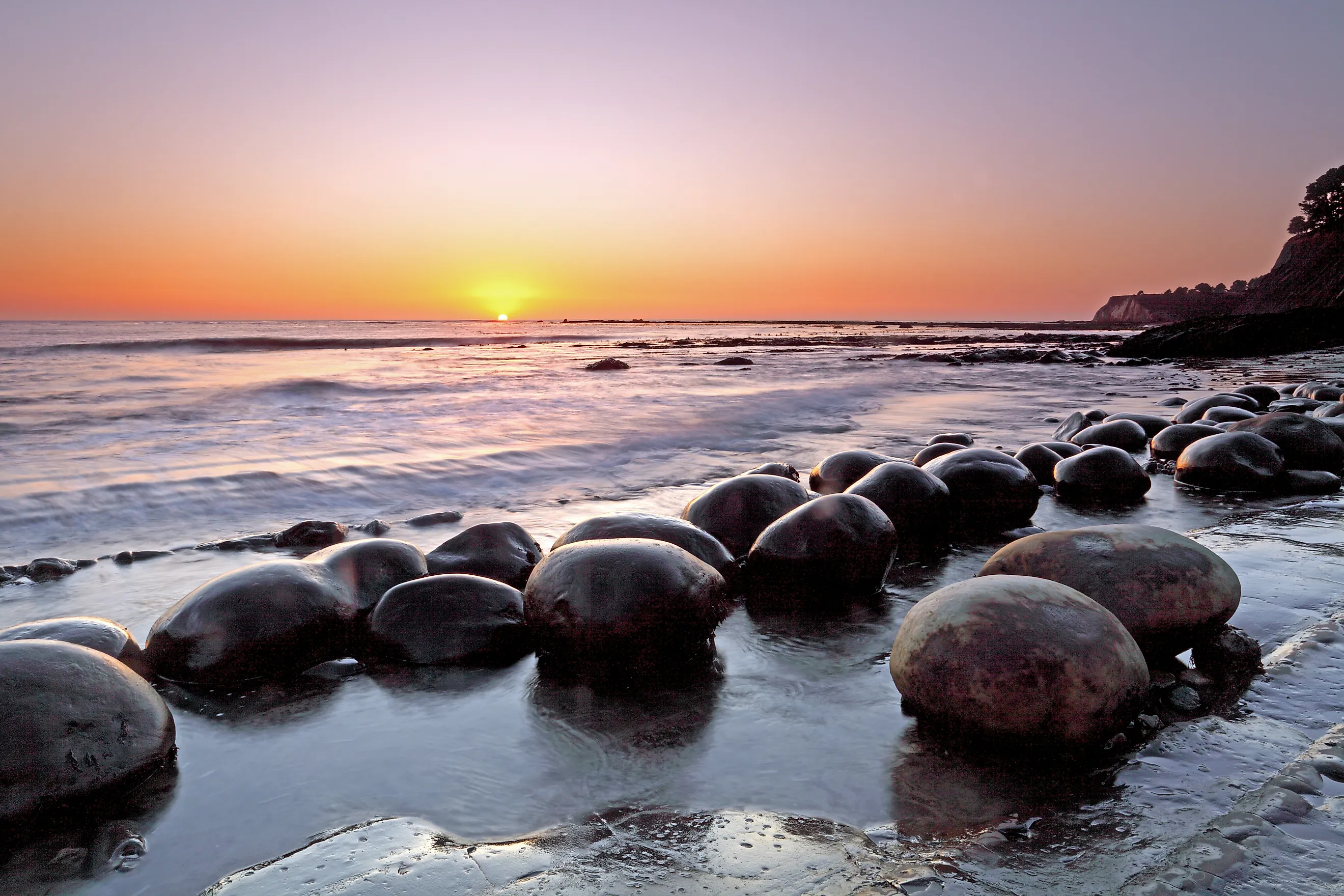
Spherical boulders arranged in rows give Bowling Ball Beach its name. Their shapes began developing long before waves exposed them. Known as concretions, they formed when minerals cemented sediment into hard masses within surrounding rock. Erosion then removed the softer material, leaving the rounded boulders we see today measuring roughly 2 to 5 feet (0.6 to 1.5 meters) across. Some even remain embedded in the nearby coastal bluffs, revealing this fascinating process at its different stages.
Part of Schooner Gulch State Beach near Point Arena, this Mendocino County shoreline is best explored during a very low tide, when the boulder field really emerges, and its parallel arrangements become much more visible.
Oregon Dunes, Oregon

Across roughly 40 miles (64 km) between Florence and Coos Bay, the Oregon Dunes combine open sands, freshwater lakes, and temperate rainforest. Wind is mostly to be thanked for piling some dunes nearly 500 feet (152 meters) above the water, creating impressive ridges that dwarf the surrounding trees.
To get around on foot, take the John Dellenback Dunes Trail near Lakeside, where a forest approach opens onto broad sandy slopes before continuing toward the Pacific Ocean. Keep in mind that walking through loose sand does take considerable effort, so allow more time than the distance alone would suggest. This section also excludes motorized vehicles, while designated riding areas elsewhere accommodate dune buggies and ATVs should you have one with you.
Fern Canyon, California

Just inland from Gold Bluffs Beach, Home Creek cuts through Fern Canyon between walls roughly 50 feet (15 meters) high. Ferns blanket the damp surfaces, creating a deeply lush, vertical garden within Prairie Creek Redwoods State Park.
Here, the easy 1-mile (1.6 km) Fern Canyon Loop follows the creek bed before climbing into the forest and returning to the canyon entrance. Expect shallow stream crossings and fallen logs, even when seasonal footbridges are installed, and bring footwear suitable for getting wet and a dry pair for afterward. Drivers need a parking reservation from May 15 through September 15 as well, as demand for the small trailhead peaks during this time.
La Jolla Sea Caves, California

La Jolla's seven sea caves burrow into the sandstone cliffs along San Diego's northern shoreline, where waves have enlarged fractures into mostly navigable chambers and passageways. Guided kayak trips from La Jolla Shores approach the openings through waters also frequented by California sea lions.
Remember that entry to the caves is dependent on safe ocean conditions. For a view from inside without paddling, however, visit Sunny Jim's Sea Cave through The Cave Store. Here, a tunnel descends 145 steps to a platform overlooking the ocean through the cave mouth. Above the cliffs, Coast Walk Trail provides yet another perspective on the eroded bluffs and the sheltered sweep of La Jolla Shores below.
Cape Flattery, Washington

At the northwestern tip of the contiguous United States, Cape Flattery overlooks the meeting of the Pacific Ocean and the Strait of Juan de Fuca. Waves here surge into caves beneath its forested cliffs, while offshore rocks provide idyllic resting places for seabirds.
The local Makah Tribe maintains a trail through coastal forest to four observation decks, with Tatoosh Island and its lighthouse visible beyond the headland. This walk covers 1.5 miles (2.4 km) round trip, including boardwalks and stairs.
Binoculars may be handy in order to scan for wildlife whichever way you go. But more importantly, be sure to obtain a Makah Recreation Pass before parking at the trailhead on the Makah Reservation near Neah Bay.
Point Reyes, California

Point Reyes occupies a truly moving piece of California, carried northwest on the Pacific Plate beside the San Andreas Fault. Widely noted as the foggiest national park in the country, when the air does clear up, its scenic peninsula extends into the ocean with its grassy headlands, long beaches, and sheltered bays along the coast north of San Francisco.
For a close look, walk the Chimney Rock Trail, a 1.75-mile (2.8 km) round trip overlooking Drakes Bay. A spring visit is especially recommended, as it brings wildflowers along the route and migrating gray whales offshore. For more wildlife nearby, the aptly named Elephant Seal Overlook faces a colony where northern elephant seals gather to breed and molt. Winter breeding season offers the best opportunities to watch adults and pups.
Devils Churn, Oregon

Incoming swells collide with returning water inside Devils Churn, sending foam and spray through a narrow inlet in the basalt around it. This unique geological feature lies within Cape Perpetua Scenic Area, just south of Yachats, where the ocean continues to erode ancient volcanic rock into a violent yet beautiful bit of shoreline.
The Trail of the Restless Waters leads down from the day-use area toward the chasm, revealing how tightly the rock walls funnel each wave. Stay for a while at the established viewpoints well above the inlet, since unexpected surges can sweep across the rocks close to the water, and possibly sweep you off your feet too. Nearby, the Cape Cove Trail connects the headland with a pleasant little sandy beach, too; a spot much more appropriate to try touching the ocean.
Redwood National and State Parks, California

The world's tallest trees grow along California's northern coast, where Redwood National and State Parks protect nearly half the remaining old-growth coast redwood forest. One tree, Hyperion, even exceeds 381 feet (116 meters), sustained by winter rains and near-constant moisture from coastal fog.
Explore this incredible woodland via the 1.5-mile (2.4 km) Lady Bird Johnson Grove loop through mature redwoods and Douglas firs, or try Stout Memorial Grove beside the Smith River. These paths each pass immense trunks beneath an impossibly high canopy, along with a verdant forest floor blanketed with ferns and other densely grown plant life. But beyond the groves, the parks also encompass a variety of ocean beaches, river valleys, and open prairies where Roosevelt elk can often be spotted grazing among the grasses.
See the Best of the West Coast's Wildlands
A closer look at any of these places will showcase the most memorable details of America's Pacific coastline, from puffins returning to Haystack Rock to young redwoods growing beneath trees older than the country itself. And definitely make plenty of time to explore beyond the first easy-to-get-to viewpoints, keeping your plans flexible enough to account for fog clearing or changing surf as well. Whether you concentrate on Washington, Oregon, or California, a few well-chosen stops picked out of this list can easily fill several days of driving and hiking.