10 Best Natural Wonders To Visit In Southern California This Year
The wildernesses of Southern California often reveal how the forces of nature have shaped this sun-soaked region. Ancient lakes have left mineral towers in the desert, while ocean waves hollow caves beneath coastal cliffs. Native palm groves survive beside desert streams, and rare Torrey pines grow above the Pacific, and visiting these places can mean a short walk, a demanding climb through sand, or even a boat trip offshore. Daily conditions matter, too, as desert heat sometimes limits hiking, ocean swell affects travel on water, and backcountry dirt roads tend to require advance planning. Wherever you head off to in SoCal this year, you can't go wrong with adding any of the spots we'll be highlighting below to your itinerary.
Arch Rock

Arch Rock is a natural granite arch surrounded by rounded boulders in Joshua Tree National Park, near White Tank Campground. The unique-looking formations here took shape underground as water entered cracks and slowly wore away their corners. Erosion later removed the soil above them, exposing the rocks visible today.
A hike of 1.4 miles (2.3 km) round trip from the Twin Tanks parking area leads to the arch, with signs along the trail explaining how the rocks formed. A short loop also offers several views of the opening, and it is recommended that you walk counterclockwise to spot it more easily.
Cooler months suit this exposed trail best, but regardless of when you go, bring water and wear shoes that better grip the uneven rocky surfaces.
Palm Canyon

Thousands of California fan palms fill Palm Canyon, creating a shaded oasis beneath the hills south of Palm Springs. These native trees grow along a creek within the canyon, which extends 15 miles (24 km) through land belonging to the Agua Caliente Band of Cahuilla Indians.
Visitors can descend from the Trading Post into the palm grove without hiking the canyon's full length. To get a different perspective, the Victor Trail climbs above the trees onto exposed slopes overlooking the canyon. For more information on the area, the Trading Post gift shop provides hiking maps for exploring the palm groves and the surrounding desert on foot.
La Jolla Sea Caves

Seven sea caves punctuate the sandstone cliffs just east of La Jolla Cove, their entrances facing the ocean toward La Jolla Shores. Waves carved these chambers into rock dating back roughly 75 million years. These days, guided kayak trips departing from La Jolla Shores offer views from the water, although swell and tides determine whether entering a cave is possible.
Sunny Jim Cave offers a different approach, as you'll have to descend through a tunnel beneath The Cave Store to reach its interior on foot. Above the caves, however, the Coast Walk Trail follows the bluff, providing great sights across the bay toward Scripps Pier. Also, sea lions frequently occupy nearby rocks, adding an element of wildlife watching to this seaside wonder.
Badwater Basin

Badwater Basin's white salt flats, at the region's far northern edge in Inyo County, sit in North America's lowest point, 282 feet (86 meters) below sea level. Water draining into this enclosed basin evaporates, leaving dissolved minerals behind and building the crust across Death Valley's arid floor. Repeated wetting and drying have created raised polygon patterns, although storms can temporarily flood the flats and alter their appearance further right before your eyes.
From the parking area on Badwater Road, a wooden boardwalk passes the small saltwater pool that gave the basin its name. Look up at the cliff behind you to find the sea level sign far overhead. But aside from the boardwalk, you can even walk onto certain parts of the dry salt, with the rugged Panamint Range spanning the opposite western horizon and providing a gorgeous backdrop to this interesting but desolate locale.
Wind Caves

The Wind Caves resemble a cluster of hollow sandstone domes perched above Fish Creek Wash in Anza-Borrego Desert State Park. Openings of different sizes cut through the pale rock, forming alcoves and small passages that you are generally free to examine up close.
Beyond the crevices, viewpoints here extend across eroded desert hills and winding washes toward the distant mountains. Wind Caves Trail covers 2 miles (3.2 km) round trip, with occasional steep sections on the climb.
Keep in mind that reaching the trailhead also requires driving roughly 4 miles (6.4 km) along Fish Creek Wash from Split Mountain Road. The sandy, rocky approach makes vehicle choice important, so check park road conditions before setting out, especially after rain.
Painted Cave

A ceiling 160 feet (49 meters) above the ocean water marks the entrance to Painted Cave on Santa Cruz Island's northwest coast. The eye-catching passage extends roughly 1,227 feet (374 meters) into the island, making it California's largest sea cave, too. Its name refers to the varied colors of the rock, lichens, and algae on its walls. After seasonal rainfall, a waterfall can spill over the entrance, adding freshwater to the ocean below and making the scene even more picturesque than it already is.
There are services offering boat excursions that include the cave, giving you one of the only ways to see its towering entrance up close. Definitely check the itinerary before booking, though, since standard island trips do not necessarily visit it, and rough seas can sometimes prevent an approach.
Trona Pinnacles

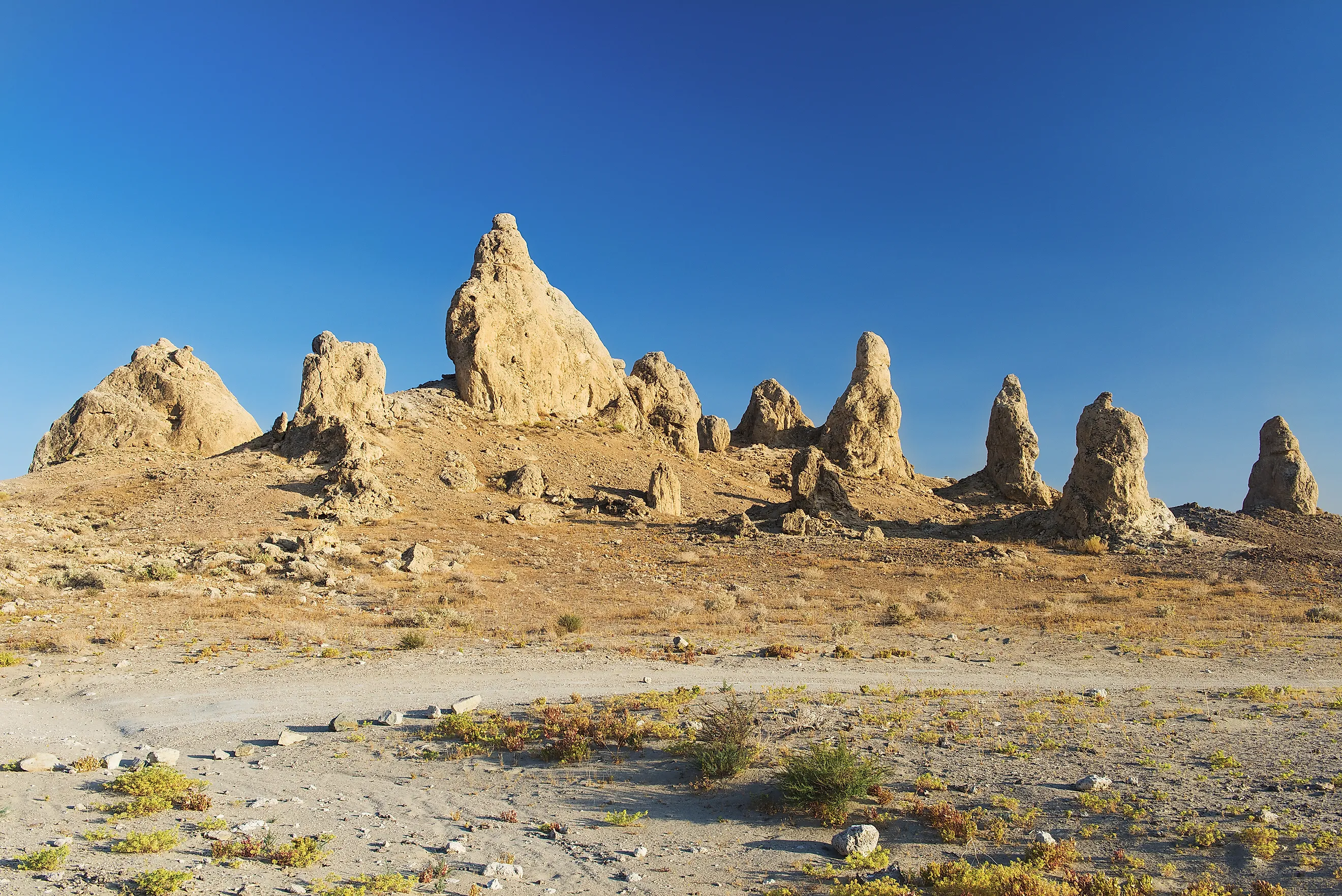
More than 500 mineral towers stand in the Searles Dry Lake basin at Trona Pinnacles, with some reaching 140 feet (43 meters). These pinnacles are made of tufa, a porous calcium carbonate rock deposited underwater between 10,000 and 100,000 years ago. At that time, Searles Lake belonged to a chain of lakes stretching from Mono Lake to Death Valley. The site became a National Natural Landmark in 1968, recognizing its exceptional collection of formations left by the ancient lake.
Today, visitors are free to walk among the isolated spires and clusters, examining their knobby surfaces against the bare lakebed. Low sunlight brings out their textures and casts long shadows across the ground, meaning sunset or sunrise are great times for some proper, otherworldly landscape photography here.
Torrey Pines State Natural Reserve

Torrey pines grow naturally in just two places: the bluffs of northern San Diego and Santa Rosa Island. At Torrey Pines State Natural Reserve, just north of San Diego, you'll be able to witness these rare trees looming over the shores of the Pacific Ocean, their irregular branches shaped by coastal winds.
Try the Guy Fleming Trail, which passes several stands of pines, as well as cacti and seasonal wildflowers, with two overlooks facing the water. Razor Point Trail then reveals deeply eroded sandstone bluffs cut into ridges and gullies. Below them, Los Peñasquitos Lagoon opens up to salt marsh habitat for countless waterbirds.
Be sure to stay on designated paths to protect the fragile vegetation and sandy soils. Drop by the historic lodge visitor center to learn about the reserve's native plants in greater detail.
Amboy Crater

Amboy Crater's dark cinder cone stands above a broad lava field beside historic Route 66 in Mojave Trails National Monument. Made from volcanic ash and cinders, the cone measures an impressive 250 feet (76 meters) high and 1,500 feet (457 meters) across. Look around, and you might notice the breach in its western side that marks where lava escaped onto the surrounding desert, too.
Hikers can cross the lava field and climb to the rim on a route of roughly 3-4 miles (4.8-6.4 km) round trip, gaining views into the crater and across the Mojave, whereas a shaded overlook near the paved parking area offers a shorter alternative. It's also best to plan a hike here for cool weather in the fall or winter, as the site has no running water and regularly sees sweltering daytime temperatures in the summer.
Kelso Dunes

Under the right conditions, sand sliding down Kelso Dunes produces a deep booming sound that can be felt through the ground, often described as the "singing dunes." This unusual phenomenon gives this portion of Mojave National Preserve an attraction beyond its sheer size and beauty.
The tallest dunes in the vicinity exceed 600 feet (183 meters), built from sands carried by wind from nearby dried lakebeds and river deposits. Climbing the main dune involves roughly 3 miles (4.8 km) round trip, but note that loose sand makes progress slower and more tiring than the distance suggests. From the crest, you'll be rewarded with a vista over a series of smaller ridges spreading toward surrounding mountains.
Those who skip the summit can opt to explore the lower slopes, where wind still leaves ripples in the sand, and small animal tracks can be seen leading into the wilds.
See the Beauty of SoCal for Yourself
Southern California's many natural wonders reward closer observation. Whether you're out to see salt forming geometric ridges, dunes producing sound, or desert streams sustaining an oasis of native palms, some places take minutes to explore while others require a strenuous hike or a booked tour. Match your travels to the conditions and allow time to examine the details. Furthermore, always stay on established routes to help keep these attractions in good shape for many years to come.