The Ocean Trenches Inside US Territory
Drop the world's tallest mountain into the deepest part of the ocean, and it would vanish, its summit still more than a mile below the surface. That place is the Mariana Trench, the deepest point on Earth, where no sunlight reaches and the pressure is strong enough to crush a submarine. Some of the planet's deepest ocean trenches lie within United States territory, each one a boundary where tectonic plates grind past or beneath one another. These are three of the deepest, and the life that somehow endures at the bottom of each.
The Mariana Trench

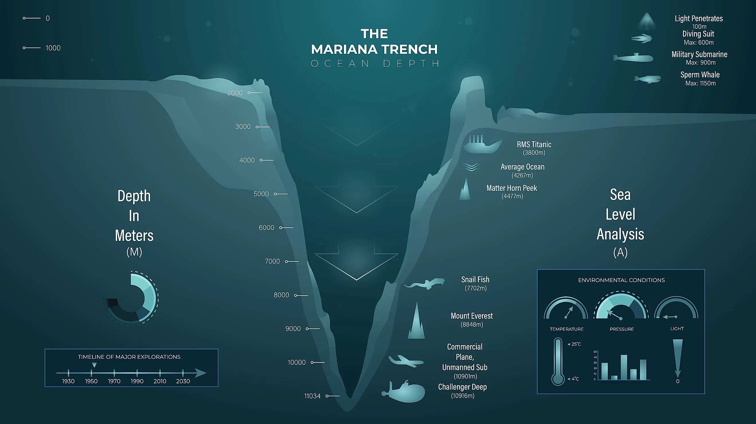
The Mariana Trench is a massive underwater canyon known as the deepest point on Earth. It is shaped like a crescent and plunges to its lowest point, the Challenger Deep, at nearly 36,000 feet. The trench lies in the western North Pacific Ocean, south of Japan and 124 miles east of the Mariana Islands, which give it its name. Because it sits in the waters of the United States territories of Guam and Saipan, most of the trench falls under U.S. jurisdiction and is protected as the Mariana Trench Marine National Monument.
The scale of the trench is gigantic, measuring around 1,580 miles long and about 43 miles wide. Its depth is often compared to Mount Everest: if the mountain were placed at the bottom of the Challenger Deep, its peak would still sit more than a mile underwater. The canyon formed through subduction, where the large Pacific Plate crashed into a lighter tectonic plate and created a deep scar on the ocean floor. At the bottom of the trench, total darkness, freezing temperatures, and immense pressure could crush a conventional military submarine like an empty soda can. Even under these conditions, deep-sea creatures and organisms live there, and people have reached the Challenger Deep in titanium pressure hulls.
The Puerto Rico Trench

The Puerto Rico Trench is a long depression beneath the ocean surface and the deepest point in the Atlantic Ocean. Like the Mariana Trench, it is a subduction zone, where the North American tectonic plate slides alongside and beneath the Caribbean plate, which is still actively grinding. Because it sits on an active plate boundary, the fault line resembles California's San Andreas Fault, and future earthquakes and tsunamis remain a geological risk.
The trench lies roughly 75 miles north of the Puerto Rican coast and extends east-west for nearly 500 miles, from the waters north of the Dominican Republic and Haiti past the U.S. Virgin Islands. Its deepest point, the Milwaukee Deep, reaches a maximum depth of about 27,493 to 27,560 feet, more than 5.2 miles down. The feature is named for the USS Milwaukee, a United States Navy Omaha-class cruiser that was sounding and mapping the ocean floor on February 14, 1939. The trench floor is home to amphipods, sea cucumbers, and giant isopods that survive despite the crushing pressure and lack of sunlight.
The Aleutian Trench

Located in the North Pacific Ocean along the southern coast of Alaska, the Aleutian Trench is a deep underwater canyon and subduction zone formed by the collision of tectonic plates. It marks the boundary where the heavy Pacific Plate slides beneath the North American Plate. This movement makes the region highly active, fueling the volcanic activity that built the Aleutian Islands and triggering the Great Alaska earthquake of 1964, the most powerful earthquake in recorded United States history.
The trench runs about 2,100 miles long and reaches all the way to the Kamchatka Peninsula of Russia. It is 50 to 100 miles wide, and its deepest point reaches 25,663 feet, roughly 90 miles southwest of the uninhabited Alaskan island of Buldir. Although the Aleutian Trench sits just south of the Bering Sea, it lies in the sub-Arctic waters of the Pacific Ocean, outside the Arctic Circle. Marine creatures such as tube worms, mollusks, anemones, and microbes thrive on the trench floor.
Mysteries of the Deep

The deep ocean floor is one of the least explored places on the planet, a world of crushing pressure and earthquake-prone trenches. The Mariana, Aleutian, and Puerto Rico Trenches are underwater landscapes shaped by an Earth that is still changing beneath us. What makes them remarkable is that life persists in some of the harshest conditions anywhere, including microbes, tube worms, and giant isopods. Studying these depths helps scientists understand how tectonic plates move, how tsunamis form, and how the planet evolves. Much of what lies at the bottom of these trenches has still never been seen.