The American Mountains With A Lake On The Summit
Water runs downhill, so a lake on top of a mountain usually means something drastic happened up there. Several American summits hold lakes in the hollowed-out tops of volcanoes that collapsed after an eruption. One of those collapses happened as recently as 1912, and the lake that has filled it since is now more than 800 feet deep. Campers swim off a designated beach inside a volcano in northern California, while the people who reach the water inside one Alaskan caldera arrive by floatplane, and in a recent decade they averaged about 71 a year. At the deepest of these lakes, nobody can legally touch the water until 2029.
Shawangunk Ridge, New York

Along the top of the Shawangunk Ridge in New York's Hudson Valley, four of the five small "sky lakes" average a pH of about 4, and their water is extremely clear, with little aquatic life and, in recent years, no fish at all. The ridge is a hard, silica-cemented conglomerate of white quartz pebbles that reaches 2,289 feet at its highest, and glaciers scoured its top during the last ice age, leaving the basins where the lakes now sit. Two of the acidic lakes are in Minnewaska State Park Preserve, where parking costs $10 per car. Lake Minnewaska is a little under half a mile long, and Lake Awosting, roughly three times larger, runs about a mile and an eighth. Ice fishing is banned on every park lake, and the swimming areas stay closed until the 2027 season.
Mohonk Lake is the exception. Its water is partly buffered, with a pH of about 7.0, and the lake runs half a mile long and about 60 feet deep on the grounds of the Mohonk Mountain House. The surrounding Mohonk Preserve charges hikers $15 Monday through Thursday and $20 Friday through Sunday and on holidays, and its 9-mile out-and-back hike to Skytop Tower gains 1,268 feet, with optional rock scrambling. From the tower, Mohonk Lake and the Mountain House are visible below, with the Catskill Mountains on the horizon.
Grand Mesa, Colorado

A state highway crosses the top of Colorado's Grand Mesa, which is billed as the largest flat-topped mountain in the world. The mesa covers about 500 square miles, and its basalt-capped plateau summit, which averages about 10,000 feet in elevation, has more than 300 lakes and reservoirs on its top and on the benches just below it. Many of the natural lakes sit in closed hollows on the uphill side of huge landslide blocks, where surface water and groundwater collect, and many others are reservoirs built by people.
The 63-mile Grand Mesa Scenic Byway runs over the top on State Highway 65 between Cedaredge and Interstate 70, and Forest Service Road 100 branches off it to Land's End at 10,500 feet. The observatory there, built in 1936 and 1937 with walls of basalt stones gathered from the mesa, was closed and boarded up as of 2022, but the viewing area outside stays open, with a view across western Colorado and into eastern Utah. That road can be driven in winter at the driver's own risk. By then, Sunset Lake and Beaver Lake are popular ice fishing spots, and the Grand Mesa Nordic Council grooms more than 30 miles of cross-country ski trails on the mesa.
Medicine Lake Volcano, California

In far northern California, near Mount Shasta, campers swim and launch boats inside the summit caldera of Medicine Lake Volcano, which U.S. Geological Survey scientists consider the largest volcano by volume in the Cascades. Shasta is a steep cone, and Medicine Lake Volcano is a broad shield whose slopes rise gently to a caldera rim near 8,000 feet. The caldera measures about 4 by 7.5 miles, and Medicine Lake covers 408 acres of it at 6,680 feet, reaching 152 feet at its deepest. Along the shore, the Modoc National Forest runs five campgrounds with $15 sites, a designated swimming area next to the picnic area, and a concrete boat ramp, and the edge of the Medicine Lake Lava Flow is a short hike from camp. The volcano has erupted nine times in the past 5,200 years, most recently less than 1,000 years ago, when Glass Mountain formed near the caldera's eastern rim, within a 15-minute drive of the campgrounds.
Mount Mazama and Crater Lake, Oregon

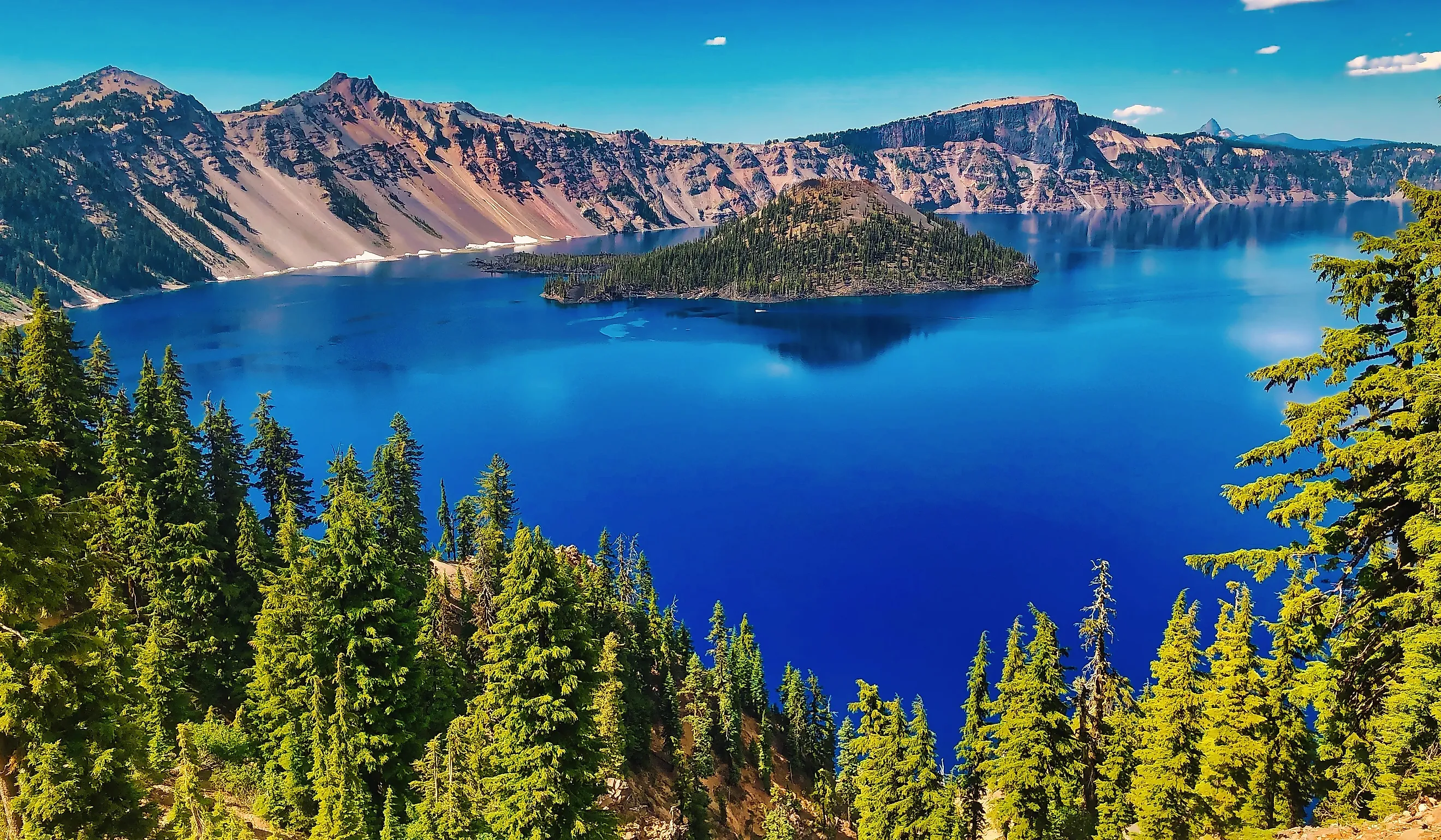
Across the state line in southern Oregon, Crater Lake National Park has the deepest lake in the United States, 1,943 feet deep, and right now there is no legal way to reach its water. The only legal access to the shore is the Cleetwood Cove Trail, which drops 700 feet in 1.1 miles of switchbacks, and the National Park Service has closed it for a major construction project until 2029. Swimming is allowed only within 100 yards of Cleetwood Cove or Wizard Island, and with the trail shut and boat trips to Wizard Island suspended through 2027, both spots are out of reach. The park itself stays open year-round through its south and west entrances, so the lake can still be seen from the rim. The 33-mile Rim Drive closes for winter on November 1 or earlier, and under snow it becomes a route for skiers and snowshoers.
The lake fills what is left of Mount Mazama, a volcano that stood about 12,000 feet tall until a massive eruption about 7,700 years ago caused its center to collapse. The caldera is 5 to 6 miles across, and no rivers or streams flow into it. Rain and snow supply all of the water, with an average of about 42 feet of snow falling on the lake each year, and the lake has not frozen over since 1949.
Between 1888 and 1941, the lake was stocked with seven species of fish, though there is no evidence that native fish ever lived in it. Two of the introduced species remain, and the Park Service estimates the lake supports about 60,000 kokanee salmon and rainbow trout. Since 1896, observers have tracked the Old Man of the Lake, a 30-foot mountain hemlock log floating with about three feet showing above the surface. The log is more than 450 years old, and between July and October 1938, it drifted 62.1 miles.
Newberry Volcano, Oregon

Up the Cascades in central Oregon, people soak in hot pools on the shore of a lake inside Newberry Volcano. The volcano covers an area about the size of Rhode Island, and its 4-by-5-mile summit caldera, formed in an explosive eruption about 65,000 years ago, holds Paulina Lake, about 250 feet deep, and the slightly higher East Lake. Hot springs heated by magma deep beneath the caldera feed both lakes in part. On Paulina Lake, the heat surfaces in undeveloped pools along the sandy shore, reached by a 1.4-mile walk on the lakeside trail or by boat. Between two and five pools appear at a time, lined with logs and rocks, as the lake level drops, and the water in them runs between about 90 and 115 degrees Fahrenheit. Digging new pools is forbidden to protect the shoreline.
A 28-pound, 5-ounce brown trout caught in Paulina Lake in 2002 remains Oregon's state record. From Paulina Peak, at 7,984 feet the highest point on the volcano, the Cascade Range is visible as far as Mount Shasta in California and Mount Adams in Washington. Paulina Lake Road into the caldera closes every winter, with 5 to 10 feet of snow possible at the summits, and until it reopens, usually before Memorial Day, the last three miles into the caldera are covered by snowmobile or on skis from Ten Mile Sno-Park.
Mount Katmai, Alaska

Mount Katmai's lake, on the Alaska Peninsula, is just over a century old. On June 6 and 7, 1912, magma drained out from beneath the mountain and erupted at Novarupta, about 6 miles west, in the largest eruption of the 20th century, and Katmai's summit collapsed into a caldera about 2 by 3 miles across. A lake has been filling it since, and it is now more than 800 feet deep, with caldera walls rising roughly 800 to 2,600 feet above the water and small glaciers on a bench beside the lake. Every route to the caldera crosses glaciers with crevasses, so visitors usually see the eruption's aftermath from below. In summer and fall, a guided tour drives the 23-mile Valley Road out of Brooks Camp into the Valley of Ten Thousand Smokes, with a 3.4-mile round-trip hike that has 1,000 feet of elevation change.
Aniakchak Volcano, Alaska

Farther down the same peninsula, air taxis from King Salmon land on Surprise Lake, inside the 6-mile-wide caldera left when a mountain about 7,000 feet tall collapsed. The monument has no roads, and in the decade before 2017, it averaged about 71 visitors a year. Warm springs, melting snow, and glaciers feed the shallow lake, which is all that remains of a once larger one.
From the shore, rafters float a calm mile to The Gates, the gap in the caldera wall that the larger lake's outflow eroded through the rim. The Aniakchak River moves swiftly through that narrow gorge, and rafters have to steer precisely around large rocks before the river carries them on toward Aniakchak Bay, a float of three to four days in all. The Park Service warns that the weather is severe and tells visitors to plan for delays getting in and, especially, getting out. Sockeye salmon travel the same river in the other direction, fighting their way upstream to spawn.
At Crater Lake, the water is in plain view and still out of reach. The park stays open all winter, and the lake can be seen from the rim, but nobody can legally get down to it until the Cleetwood Cove Trail reopens in 2029. Katmai's lake, which filled a caldera that did not exist before 1912, sits behind glaciers split by crevasses, and at Aniakchak, where air taxis land on the lake itself, the Park Service tells visitors to plan for delays getting out. Medicine Lake is the opposite case, with a swimming area and a boat ramp that open with the campgrounds each summer, and the swimmers there wade into a caldera lake at 6,680 feet. When the Cleetwood Cove Trail does reopen, the first people back in Crater Lake will find surface water that averages 57 degrees.