10 Highest Elevation Lakes In The US
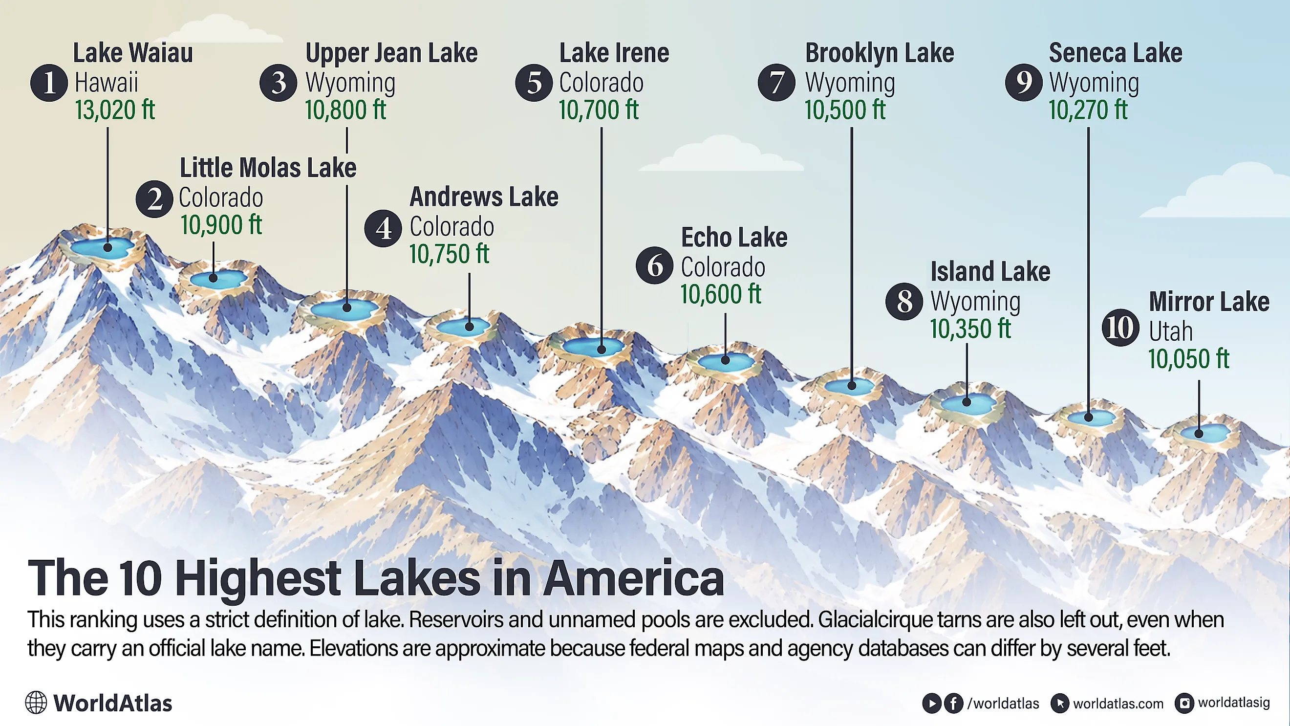
Above 10,000 feet, America's mountain lakes occupy a world of thin air, lingering snow, and remarkably short summers. Hawaii's Lake Waiau rises above 13,000 feet, while the Rockies and Uintas hold the rest of these exceptionally high waters. Natural lakes form the cutoff, so reservoirs and glacial cirque tarns do not count. Elevations can vary slightly between federal maps and agency records because different surveys and vertical datums produce small differences.
Lake Waiau, Hawaii

At 13,020 feet on Mauna Kea, Lake Waiau occupies a volcanic basin above almost all plant life. The U.S. Geological Survey identifies it as the only alpine lake in the Hawaiian Islands. Rain and snow collect inside Pu'u Waiau, where an impermeable layer prevents the water from draining through Mauna Kea's porous volcanic rock. That geology allows a permanent lake to exist in a place that otherwise looks remarkably dry.
Waiau usually covers about 1.8 acres, so it is small, but the science packed into its sediments is extraordinary. USGS researchers have tracked changes in its water level and studied cores containing organic material more than 12,000 years old. The lake lies inside the Mauna Kea Ice Age Natural Area Reserve. Bare volcanic ground surrounds the blue water, and snow can appear on the upper mountain in winter. It is an unusual Hawaiian scene, with no beach or tropical vegetation anywhere in sight.
Little Molas Lake, Colorado

A short dirt road near Molas Pass leads to Little Molas Lake at roughly 10,912 feet in Colorado's San Juan Mountains. Federal topographic maps place the water just below 11,000 feet, west of U.S. Highway 550 and a few miles south of Silverton. The Forest Service maintains a primitive campground beside the lake, and passenger cars can normally reach it in dry conditions. There is no drinking water or trash service, so the campground stays refreshingly simple. The Colorado Trail passes nearby, making a longer mountain hike easy to add to the day. Little Molas has enough open water to look unmistakably like a lake, with dark conifers along the shore and broad San Juan ridges beyond. Reaching scenery this high usually takes far more effort, yet here the shoreline is only a short drive from one of Colorado's great mountain highways.
Upper Jean Lake, Wyoming

Getting to Upper Jean Lake means earning the view. USGS mapping places the lake at about 10,804 feet in Wyoming's Wind River Range, deep inside the Bridger Wilderness. Roads are far behind by the time hikers reach this country, where the trail passes through increasingly open mountain terrain.
The Highline Trail crosses the Jean Lakes area. Lower Jean Lake occupies the same drainage, while granite ridges rise around the upper basin. Backpackers moving through this part of the Winds encounter long stretches with no developed recreation sites at all.
Upper Jean has a broad lake surface, not the appearance of a tiny alpine pool. Exposed rock becomes more prominent as elevation increases, and open ground reaches toward the shoreline. After the long approach, that wide sheet of water beneath the granite ridges is a terrific payoff.
Andrews Lake, Colorado

U.S. Highway 550 comes surprisingly close to Andrews Lake, a natural coldwater lake high in Colorado's San Juan Mountains. Colorado Parks and Wildlife places the surrounding State Wildlife Area between roughly 10,745 and 10,791 feet. The agency allows fishing and hand-launched boats, while motorized boating is prohibited. That makes the compact lake especially inviting for a quiet paddle.
Conifers crowd the shoreline, and the surrounding peaks rise sharply beyond them. Snow often lingers nearby well after lower Colorado valleys have warmed for summer. Andrews covers about 13 acres, according to Colorado Parks and Wildlife, giving it plenty of open water in photographs and from the shore. Travelers can step out near the highway and immediately find themselves beside a genuine high San Juan lake above 10,700 feet.
Lake Irene, Colorado

Trail Ridge Road puts Lake Irene within easy reach on the western side of Rocky Mountain National Park. Federal mapping places the water near 10,627 feet, below the open tundra around the Continental Divide. Nearby park facilities sit slightly higher because the ground rises quickly around the basin. A short path leads from the Lake Irene Picnic Area to the shoreline when the seasonal highway is open. Heavy snow affects this section of the park well into the year, and Trail Ridge Road closes through winter. Summer is wonderfully different. Spruce and fir reach the water's edge, while higher ridges rise above the forest. The walk is brief, but the surroundings are unmistakably subalpine, making Irene an easy way to experience high Rocky Mountain country without spending hours on the trail.
Echo Lake, Colorado

Ice Age glaciers left the key feature behind at Echo Lake, a natural dam built from glacial debris. U.S. Geological Survey research explains that a lateral moraine blocked the drainage below present-day Mount Blue Sky. Water collected behind the moraine, creating the lake at about 10,600 feet. The paved road beside it came much later.
Echo Lake belongs to Denver's mountain park system. Forest reaches much of the shoreline, while the Mount Blue Sky road climbs toward alpine terrain nearby. Denver also hosts ranger activities around the lake, including wildlife programs.
The moraine gives the visit an extra geological twist. It records a much colder period when valley glaciers occupied these mountains. Today, the evidence sits beside an easily reached lake where visitors can examine Colorado's glacial past without a backcountry hike.
Brooklyn Lake, Wyoming

Wyoming's Snowy Range rises quickly above the small town of Centennial, with Brooklyn Lake near the top of that climb. USGS mapping places the water around 10,530 feet. Recreation.gov lists the adjacent Forest Service campground at roughly 10,500 feet, so the lake remains reachable by vehicle during the snow-free season.
Fishing draws plenty of summer visitors, and the campground provides a useful base for exploring the Medicine Bow high country. Forest lines much of the shore, with pale granite visible higher on the surrounding slopes. Snow makes the practical season fairly short at this altitude. Once the road clears, Brooklyn Lake offers a generous stretch of open water beneath the Snowy Range. It looks every bit like the substantial mountain lake its elevation suggests.
Island Lake, Wyoming

Roughly ten miles of hiking from Elkhart Park brings backpackers to Island Lake in Wyoming's Wind River Range. USGS mapping places the water near 10,351 feet inside the Bridger Wilderness. The route climbs from forest into increasingly open granite country before the broad lake comes into view. Island Lake is large enough to dominate its basin, with a long shoreline beneath high ridges. Fremont Peak and the country toward Titcomb Basin add serious scale to the backdrop. Many backpackers camp nearby before continuing deeper into the range or toward climbing routes. By the time the shoreline appears, roads and developed recreation sites are well behind. What remains is a substantial natural lake above 10,000 feet in the heart of one of the Lower 48's most dramatic mountain landscapes.
Seneca Lake, Wyoming

The trail from Elkhart Park reaches Seneca Lake before continuing toward Island Lake and Titcomb Basin. Federal topographic data place Seneca at about 10,272 feet in the Wind River Range. Hikers gain more than 1,000 feet from the trailhead before arriving, with granite becoming increasingly prominent along the route.
Seneca is large enough to feel like a destination rather than another patch of water beside the trail. Its long shoreline curves beneath rocky slopes, and backpackers commonly stop here overnight on longer Bridger Wilderness trips.
The terrain beyond the lake becomes increasingly open as the route pushes farther into the Winds. After the steady climb from Elkhart Park, Seneca offers plenty of shoreline for dropping a pack and enjoying the view before the next day's miles begin.
Mirror Lake, Utah

One of Utah's easiest high-elevation lake stops waits beside the Mirror Lake Scenic Byway in the Uinta Mountains. USGS-derived mapping places Mirror Lake near 10,082 feet, while Utah recreation sources commonly round its elevation to about 10,050 feet. Bald Mountain rises nearby to 11,943 feet, creating a bold mountain backdrop without requiring a long approach.
The Uinta-Wasatch-Cache National Forest manages the lake for fishing, paddling, camping, and hiking. Canoes and kayaks are allowed, while gas-powered engines are prohibited. A trail circles the water, so quieter shoreline views are only a short walk from the parking area. Heavy snow closes the highway for much of the year. Once the road reopens, visitors can reach a broad natural lake above 10,000 feet almost immediately.
Short Seasons, High Water
Every lake on this list sits above 10,000 feet, and most of them are reachable by car once the seasonal roads open. The exceptions are the three Wind River Range lakes, Upper Jean, Island, and Seneca, where the trail from the road runs for miles before the water appears. Lake Waiau is the outlier in a different way, a small permanent pool on a Hawaiian volcano far from any Rocky Mountain road. Snow sets the calendar at all ten, which keeps the practical season short and makes a clear summer day at any of these shorelines worth planning around.