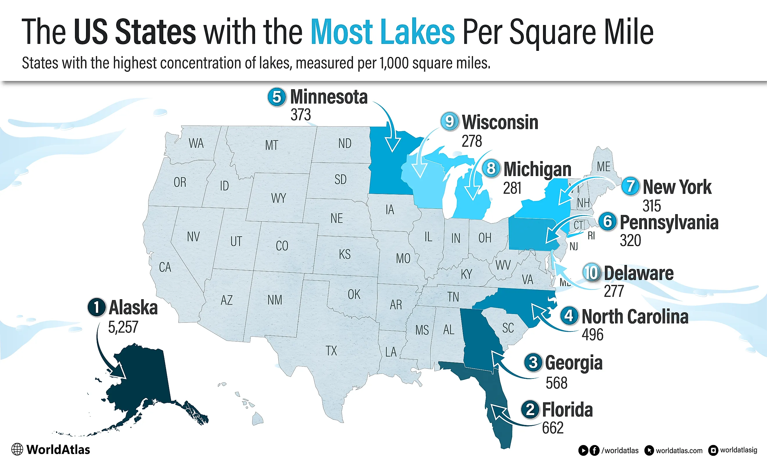
The US States With the Most Lakes Per Square Mile
Minnesota calls itself the Land of 10,000 Lakes, yet the state's own count is 11,842 lakes of at least 10 acres. Wisconsin claims about 15,000, using a smaller size threshold than some national databases. Alaska dwarfs both, with more than 3 million lakes by state and federal estimates. The trouble is that none of these numbers were measured the same way, so "which state has the most lakes" has no fixed answer until you fix the definition first. This article sets one: lake density, the number of lakes and reservoirs per 1,000 square miles of land.
The US States With the Most Lakes Per Square Mile
| Rank | State | Lakes/1,000 mi2 (approximate values) |
|---|---|---|
| 1 | Alaska | 5,257 |
| 2 | Florida | 662 |
| 3 | Georgia | 568 |
| 4 | North Carolina | 496 |
| 5 | Minnesota | 373 |
| 6 | Pennsylvania | 320 |
| 7 | New York | 315 |
| 8 | Michigan | 281 |
| 9 | Wisconsin | 278 |
| 10 | Delaware | 277 |
* the ranking above takes into account lakes and reservoirs
1. Alaska - about 5,257 lakes per 1,000 mi2

Alaska stands far above every other state for lake density. Government sources commonly describe the state as having more than 3 million lakes larger than 5 acres, along with more than 12,000 rivers and a major share of the nation's surface-water resources. Spread across roughly 570,641 mi2 of land, that works out to about 5,257 lakes per 1,000 mi2.
That figure is not directly comparable to the lower-48 LAGOS-US ranking because it uses a 5-acre threshold rather than the 1-hectare threshold used below. If Alaska were mapped using the smaller LAGOS cutoff of 2.47 acres, its count would almost certainly be even higher. Even with the larger 5-acre threshold, however, Alaska's density is so far beyond every other state's that its first-place position is not in doubt.
Alaska's lakes are not merely scenic backdrops. Many are unnamed, remote, and reachable only by floatplane, boat, or long overland travel. They support salmon, trout, grayling, waterfowl, and subsistence fishing and hunting across rural and Alaska Native communities. Lake Iliamna, the state's largest, stretches some 77 miles across southwest Alaska and feeds the Bristol Bay sockeye runs through the Kvichak River; nearby Becharof Lake, second-largest in the state, sits inside its own national wildlife refuge on the Alaska Peninsula. Beyond these named giants lie countless tundra, glacial, and permafrost-influenced lakes that shape the lowlands, river valleys, and coastal plains. In Alaska, lake density is not just a statistic; it is one of the defining facts of the landscape.
2. Florida - 662 lakes and reservoirs per 1,000 mi2
Florida has the highest lake density in the lower 48. LAGOS-US counts 35,508 lakes and reservoirs of at least 1 hectare in the state, and when divided by Florida's land area, that produces a density of about 662 lakes and reservoirs per 1,000 mi2. The number is not a typo: Florida outranks the classic Upper Midwest lake states by density.
Geology explains much of the pattern. Florida sits on a broad limestone platform, and the state's karst terrain is shaped by water dissolving limestone and dolomite over long periods of time. The result is a landscape full of sinkholes, depressions, springs, and closed basins, many of which hold water. Human-made and managed waterbodies add to the count, especially across central and south Florida.
Lake Okeechobee is Florida's most visible inland-water landmark. At about 730 mi2, it is the largest lake in the southeastern United States. But Florida's density comes less from one huge lake than from thousands of smaller lakes, ponds, sinkhole basins, reservoirs, and managed waters. The Kissimmee Chain of Lakes, the St. Johns River basin, and the lake country of central Florida help make the state one of America's major freshwater-fishing regions, while many waters also serve flood-control, water-supply, and wildlife-habitat functions.
3. Georgia - 568 lakes and reservoirs per 1,000 mi2

Almost every famous body of water in Georgia has a dam at one end of it. Before the twentieth century the state had few natural lakes to speak of, so its biggest waters are the ones engineers built: Lake Lanier northeast of Atlanta, Lake Hartwell and J. Strom Thurmond Lake along the Savannah River on the South Carolina line, and a long roster of power and flood-control impoundments behind them. LAGOS-US counts 32,664 lakes and reservoirs of at least 1 hectare statewide, a density of about 568 per 1,000 mi2, and the great majority are human-made.
Lanier is the one most Georgians picture first. The U.S. Army Corps of Engineers closed Buford Dam on the Chattahoochee in 1956, and the reservoir it created now supplies drinking water to much of metro Atlanta while drawing millions of visitors a year to its marinas and islands. Hartwell and Thurmond, both shared with South Carolina, are larger still by surface area; Thurmond, which many Georgians know by its older name of Clarks Hill, is the biggest lake touching the state. Smaller Corps and utility reservoirs such as Allatoona and West Point fill in the rest of the map.
What makes Georgia dense, then, is less geology than the mid-century push to dam its rivers for power, water, and flood protection. Those projects drowned river valleys and farm towns and replaced them with shoreline, and the shoreline in turn reorganized where people spend their weekends. North of Atlanta especially, a lake address has become its own kind of suburb, built around boat ramps, fishing tournaments, and pontoon traffic on water that did not exist a lifetime ago.
4. North Carolina - 496 lakes and reservoirs per 1,000 mi2

North Carolina holds two completely different kinds of lake country, and both feed its density of about 496 lakes and reservoirs per 1,000 mi2 (24,104 in all, by LAGOS-US). In the Piedmont, the Catawba River has been dammed so many times that it reads as a staircase of reservoirs: Lake Norman, the largest, sits above Mountain Island Lake and Lake Wylie, with Lake Hickory and Lookout Shoals strung upstream. The Yadkin-Pee Dee carries its own chain, including High Rock Lake and Badin Lake. Down on the coastal plain, the water is natural and strange: Lake Mattamuskeet, the state's largest natural lake, is a shallow sheet barely a few feet deep, ringed by the Carolina bays and pocosin wetlands that pock the flatlands.
Norman is the giant and the one that reshaped a region. Duke Power began Cowans Ford Dam in 1959 and brought the hydro station online in 1963, backing the Catawba up into the largest man-made lake in the state. Its shoreline now defines towns like Cornelius, Davidson, Mooresville, and Huntersville, and Visit Lake Norman pegged the lake's FY2024 economic impact at about $23.7 million. Mattamuskeet, by contrast, draws not boaters but tens of thousands of migrating tundra swans and snow geese to its national wildlife refuge each winter.
The split personality is the point. Many of North Carolina's "lakes" are working reservoirs, doing the unglamorous jobs of generating power, holding back floods, and watering the fast-growing Piedmont, while the coastal-plain lakes are wild, shallow, and bird-rich. Together they give a state not usually filed alongside Minnesota or Michigan a genuinely lake-shaped landscape.
5. Minnesota - 373 lakes and reservoirs per 1,000 mi2

Minnesota remains one of America's great lake states, even if it does not lead by density. LAGOS-US counts 29,669 lakes and reservoirs of at least 1 hectare in Minnesota, producing a density of about 373 per 1,000 mi2. The state's better-known slogan, "Land of 10,000 Lakes," comes from a different state definition: Minnesota officially counts 11,842 lakes of 10 acres or more.
Glaciation did the heavy lifting. Retreating ice sheets scraped and blocked drainage across the Canadian Shield, the northern forests, and the prairie pothole region. Depressions filled with meltwater and rain, creating the lake-studded landscape that now defines much of the state. In northern Minnesota, lakes are tied to cabins, canoe routes, walleye fishing, loons, and summer migration to the water. In winter, those same lakes become ice-fishing villages dotted with shanties and plowed roads.
Some Minnesota lakes have national symbolic weight. Lake Itasca, in Minnesota's oldest state park, is the headwaters of the Mississippi River, where visitors can walk across the young river before it begins its long journey to the Gulf of Mexico. Mille Lacs Lake, Lake of the Woods, Leech Lake, and Red Lake, the largest lake lying wholly within the state, reinforce Minnesota's identity as one of the country's defining freshwater landscapes, along with the Boundary Waters canoe country on the Canadian border.
6. Pennsylvania - 320 lakes and reservoirs per 1,000 mi2

Few people rank Pennsylvania among the lake states, yet its 14,314 lakes and reservoirs work out to about 320 per 1,000 mi2, ahead of New York, Michigan, and Wisconsin by this measure. Two forces built that map. The last ice sheet left glacial lakes and wetlands scattered across the northern tier, through the Poconos and the Endless Mountains. Twentieth-century engineers added the rest: reservoirs, mill ponds, and managed waters across the Appalachian Plateau and the interior valleys, built for power, water supply, and flood control.
Lake Erie gives Pennsylvania a Great Lakes shoreline, but the inland waters carry the ranking. Lake Wallenpaupack, the state's signature recreation reservoir, was completed in 1926 with its hydroelectric plant and now draws summer crowds into the Poconos. Raystown Lake, the largest lake lying entirely within Pennsylvania, fills a long valley in the south-central counties, while Pymatuning Reservoir straddles the Ohio line to the west; both pull boaters, anglers, and campers through the warm months.
Pennsylvania's lake story is therefore not only about wilderness. It is about a heavily settled state adapting rivers and valleys for industry, flood control, drinking water, tourism, and weekend recreation. Its lakes and reservoirs may be less famous than those of Minnesota or Michigan, but by density they are a major part of the state's landscape.
7. New York - 315 lakes and reservoirs per 1,000 mi2

New York follows closely behind Pennsylvania, with 14,841 lakes and reservoirs and a density of about 315 per 1,000 mi2. Its lake geography is unusually varied: wilderness ponds and mountain lakes in the Adirondacks, long glacial troughs in the Finger Lakes region, reservoirs in the Hudson and Catskill watersheds, and major border waters such as Lake Champlain, Lake Erie, and Lake Ontario.
The Adirondack Park is the centerpiece. Created in 1892, it is the largest publicly protected area in the contiguous United States, larger than Yellowstone, Everglades, Glacier, and Grand Canyon National Parks combined. Its forests, lakes, ponds, and rivers make northern New York one of the country's great paddling and lake-cabin regions.
Farther south and west, the Finger Lakes give New York a different lake identity. These long, narrow glacial lakes cut through central New York and support boating, swimming, state parks, college towns, and one of the most recognizable wine regions in the eastern United States. Lake George, often called the Queen of American Lakes, adds a classic resort-lake tradition, while Lake Champlain links New York's lake story to Vermont and Quebec. New York's lake density is not concentrated in one kind of water; it is spread across mountains, valleys, reservoirs, and glacial basins.
8. Michigan - 281 lakes and reservoirs per 1,000 mi2

Michigan's identity is inseparable from water, but this ranking focuses on inland lakes and reservoirs rather than the Great Lakes themselves. LAGOS-US counts 15,905 qualifying inland lakes and reservoirs in Michigan, giving the state a density of about 281 per 1,000 mi2. The Great Lakes define Michigan's outline, economy, and culture, but they are not what drive this particular density figure.
Michigan's inland lake landscape was shaped by glaciation across both the Upper and Lower Peninsulas. Houghton Lake, at about 20,000 acres the largest inland lake in the state, leads a roster that includes Higgins Lake, Burt Lake, and Mullett Lake. Deep, clear Torch Lake, often singled out as one of the state's most striking waters, runs more than 280 feet down. Together with thousands of smaller waters, these support fishing, boating, cottages, swimming, and summer tourism. The state's official materials commonly describe Michigan as having more than 11,000 inland lakes, and no resident is far from water.
The Inland Waterway, or Inland Route, shows how connected Michigan's inland waters can be. The route runs through a chain of lakes and rivers in the northern Lower Peninsula, linking the Conway area near Petoskey with Cheboygan on Lake Huron. It includes Crooked Lake, Burt Lake, Mullett Lake, and connecting rivers, giving boaters a protected inland route through one of the state's classic summer regions.
9. Wisconsin - about 278 lakes per 1,000 mi2, with a caveat

Wisconsin is one of America's classic lake states, and its familiar statewide count is about 15,000 lakes. Using the commonly cited Wisconsin figure of 15,074 lakes and the state's land area, the density is about 278 lakes per 1,000 mi2. That places Wisconsin just behind Michigan and just ahead of Delaware, whose LAGOS-US count of 540 lakes and reservoirs yields roughly 277 per 1,000 mi2.
The caveat matters. Wisconsin's well-known 15,000-lake claim uses a threshold of about 2.2 acres, which is slightly below the 1-hectare, or 2.47-acre, LAGOS-US cutoff used for the lower-48 comparison above. Because Wisconsin and Delaware are separated by only about one lake per 1,000 mi2 using rounded figures, the exact order of ninth and tenth place is sensitive to the lake-size definition. Under a strict one-hectare extraction, Wisconsin should be rechecked directly against LAGOS-US before treating its rank as final.
Whatever the exact cutoff, Wisconsin is undeniably lake-rich. The most intense lake country lies in the glaciated north, especially around Vilas, Oneida, Iron, Sawyer, and surrounding counties. Lake Winnebago, Lake Mendota, the Eagle River Chain of Lakes, and the Minocqua area anchor a culture of boating, fishing, water skiing, cabins, supper clubs, and Friday fish fries. In winter, ice-fishing shanties spread across frozen lakes, while the Ice Age Trail passes kettle lakes and other glacial features left by the last advance of the ice sheet.
10. Delaware - about 277 lakes and reservoirs per 1,000 mi2

Delaware rounds out the top ten because density rewards compact states. LAGOS-US counts 540 lakes and reservoirs of at least 1 hectare in Delaware. Spread across the state's small land area, that equals about 277 lakes and reservoirs per 1,000 mi2, placing it just behind Wisconsin under the rounded figures used here.
Delaware is not usually grouped with America's classic lake states, but its water landscape is dense because many of its lakes are small ponds, reservoirs, millponds, and managed impoundments. The state sits on the Atlantic Coastal Plain, where low relief, wetlands, slow drainage, and human water management have produced many small inland waters. In a large state, that raw count would not stand out. In Delaware, it is enough to push the state into the national top ten by density.
Lums Pond, in northern Delaware, is one of the state's best-known inland waters and anchors Lums Pond State Park. Farther south, Trap Pond is tied to a different kind of watery landscape, with bald cypress, wetlands, paddling routes, and swamp habitat. Delaware's lake story is therefore less about giant natural lakes and more about small, closely spaced waters that serve recreation, wildlife, drainage, water supply, and local landscape identity.
Delaware's placement also reinforces the main caveat of the ranking: density is not the same thing as total lake abundance. Alaska, Florida, Minnesota, and Wisconsin have far more famous lake identities, but Delaware's small size means even a modest number of qualifying lakes and reservoirs produces a high per-square-mile figure.
What the Ranking Shows
The larger lesson is methodological. There is no single permanent answer to "Which state has the most lakes?" unless the definition of a lake is fixed first. Change the size threshold, include or exclude reservoirs, or count only named lakes, and the ranking changes. But under a density approach, lake country reaches well beyond the Upper Midwest, taking in Florida's limestone basins, Georgia's reservoirs, New York's glacial valleys, Pennsylvania's mountain waters, Delaware's compact coastal-plain ponds, and Alaska's vast, water-filled north. Alaska towers above the rest of the country, even though its count must be handled separately because it falls outside the lower-48 LAGOS-US dataset. Florida leads the conterminous United States, thanks to karst terrain, thousands of small basins, and managed waters. Georgia and North Carolina rank high because reservoirs and impoundments are so numerous. Minnesota, Michigan, and Wisconsin still stand out as classic glacial lake states, while Pennsylvania and New York show how glaciation, reservoirs, and mountain waters combine to create dense inland-water landscapes.