The Largest Lakes In The World By Depth
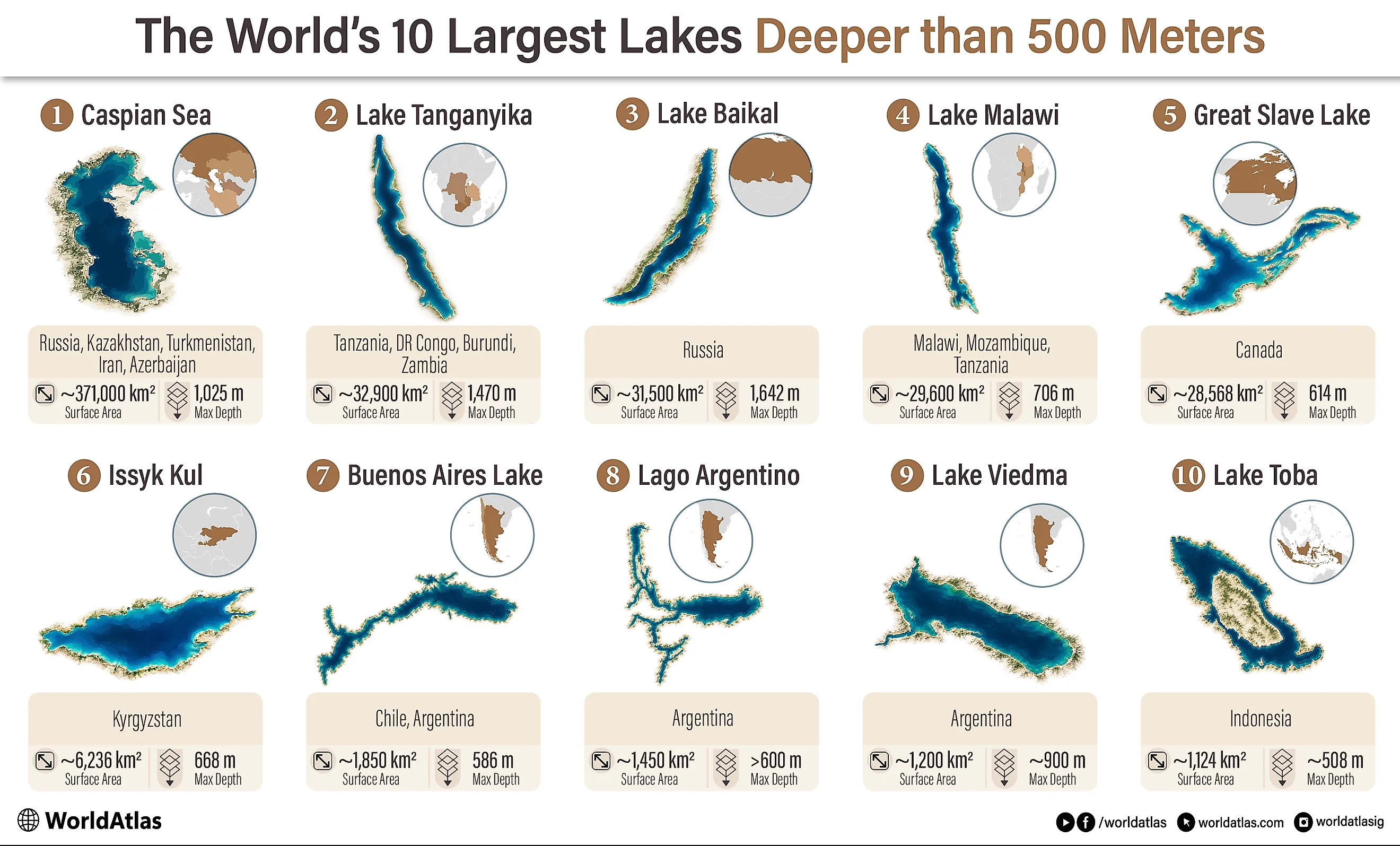
The deepest lakes are not the ones at the top of this ranking. To qualify, a lake needs a maximum depth past 500 meters, and from there the order follows surface area. That produces a very different list from a straight ranking of the world's deepest lakes. Great Slave Lake, for example, reaches 614 meters in one eastern basin and covers more than 28,000 square kilometers, while far deeper Lake Viedma covers only a fraction of that area.
This ranking includes natural surface lakes and treats the Caspian Sea as a lake because it is an enclosed inland water body with no natural connection to the ocean. Reservoirs and subglacial lakes are excluded. Surface areas can shift with water level, glacier retreat, and mapping methods, so the figures below use modern scientific or government measurements where available.
1. Caspian Sea - 371,000 km2, 1,025 m Deep

The Caspian Sea dwarfs every other lake that clears the 500-meter depth cutoff. It covers about 371,000 square kilometers, although its exact area changes with water level, and its southern basin drops to 1,025 meters. The north is dramatically different. Much of that end is only a few meters deep, so the Caspian combines a vast shallow shelf with a genuinely deep southern depression.
Russia, Kazakhstan, Turkmenistan, Iran, and Azerbaijan share its shoreline. Most of its river inflow comes from the Volga, yet none of its water reaches the ocean. That closed drainage makes it an endorheic lake despite the familiar "sea" in its name. Its water is saline, with conditions varying considerably across the basin. No other qualifying lake comes remotely close in surface area. Lake Tanganyika, the next entry, covers less than one-tenth as much water.
2. Lake Tanganyika - 32,900 km2, 1,470 m Deep

Lake Tanganyika covers about 32,900 square kilometers across Tanzania, the Democratic Republic of the Congo, Burundi, and Zambia. The long, narrow basin follows the western branch of the East African Rift, where tectonic movement created depressions that eventually filled with water. At its deepest point, Tanganyika reaches 1,470 meters, second only to Lake Baikal among surface lakes.
That depth has a major effect on what happens underwater. A large part of Tanganyika's deep water contains too little oxygen to support most animals, leaving much of its active biological community in the upper layers. Those upper waters are where the major fisheries and an exceptional number of endemic cichlid fishes are found.
Tanganyika also holds roughly 18,900 cubic kilometers of water. Its place at number two here comes from area, but it would remain close to the top under almost any measure of lake size. Few lakes are simultaneously this long, this deep, and this voluminous.
3. Lake Baikal - 31,500 km2, 1,642 m Deep

Lake Baikal covers roughly 31,500 square kilometers of southeastern Siberia and drops 1,642 meters at its deepest measured point. That makes it the deepest lake on Earth, although Tanganyika is slightly larger in surface area under the rules of this ranking. Baikal occupies an active continental rift where Earth's crust is slowly pulling apart, creating a long basin with steep sides and an exceptionally low lake floor.
Its volume is just as remarkable. Baikal contains close to one-fifth of the world's unfrozen surface freshwater. Scientists generally place its age near 25 million years, long enough for evolution to produce an unusually distinct set of species inside an isolated freshwater system. The lake is home to the endemic Baikal seal along with hundreds of species found nowhere else. In a straightforward depth ranking, Baikal is first. Here, it ranks third because Tanganyika's surface area is slightly greater.
4. Lake Malawi - 29,600 km2, 706 m Deep

Lake Malawi, also called Lake Nyasa or Lago Niassa, covers about 29,600 square kilometers between Malawi, Mozambique, and Tanzania. Its deepest point reaches approximately 706 meters near the western side of the basin. Like Tanganyika, Malawi occupies part of the East African Rift, where faulting created a long depression capable of holding an enormous volume of water.
The basin is not equally deep everywhere. In parts of the north and east, steep faulted shores continue quickly into deep water, while the southern end shelves much more gradually. That varied underwater terrain helps explain one of the world's most famous freshwater evolutionary radiations.
Hundreds of cichlid species occur in Lake Malawi, many with tiny geographic ranges or specialized habitats. The lake's only surface outlet is the Shire River, which eventually joins the Zambezi system. Malawi is only a few thousand square kilometers smaller than Baikal in surface area, even though Baikal reaches more than twice its maximum depth.
5. Great Slave Lake - 28,568 km2, 614 m Deep

Great Slave Lake covers about 28,568 square kilometers of Canada's Northwest Territories, putting it surprisingly close to Lake Malawi in surface area. Its 614-meter maximum occurs in Christie Bay within the East Arm. The western basin is far shallower, reaching only about 163 meters at its deepest point. That single unusually deep eastern section is why the lake clears the 500-meter requirement at all.
The contrast corresponds with the geology beneath the lake. The East Arm lies on the ancient Precambrian Shield, while younger sedimentary rocks underlie much of the west. Water enters chiefly through the Slave River and leaves through the Mackenzie River, eventually reaching the Arctic Ocean.
Its average depth is only about 41 meters, which makes Great Slave an especially useful example of how this ranking works. Average depth has no bearing on eligibility. Once the 614-meter depression in Christie Bay satisfies the depth requirement, the lake ranks fifth on surface area alone.
6. Issyk-Kul - 6,236 km2, 668 m Deep

The gap between fifth and sixth place is enormous. Issyk-Kul covers about 6,236 square kilometers in Kyrgyzstan, less than one-quarter of Great Slave Lake's area, but descends to 668 meters. It lies around 1,607 meters above sea level between the Kungei Ala-Too and Terskei Ala-Too ranges of the Tien Shan.
Issyk-Kul has no current surface outlet. More than a hundred rivers and streams feed the basin, while evaporation removes much of the incoming water. As dissolved minerals remain behind, the lake has become slightly saline. Modern limnological studies consistently use a surface area of 6,236 square kilometers and a maximum depth of 668 meters.
The high elevation is part of what makes its size so unusual. A water body stretching nearly 180 kilometers through a mountain basin might look shallow on a map, but its deepest floor lies more than half a kilometer below its surface. After Issyk-Kul, the qualifying lakes become dramatically smaller again.
7. General Carrera/Buenos Aires Lake - 1,850 km2, 586 m Deep
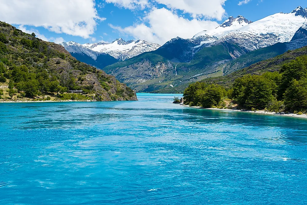
General Carrera/Buenos Aires Lake straddles the Chile-Argentina border in Patagonia, where the same water body is called General Carrera on the Chilean side and Buenos Aires on the Argentine side. Together, the two portions cover about 1,850 square kilometers. Hydrographic surveys found a maximum corrected depth of 586 meters in the western basin.
The bottom is much more complicated than a single bowl. Geological research has identified deep basins separated by shallower sills, with tectonic faults helping control their shape. Glaciers later cut through the landscape and further modified the depression. The deepest sections now extend hundreds of meters below sea level even though the lake surface itself stands above it.
Water drains west through Lake Bertrand and then the Baker River toward the Pacific. General Carrera/Buenos Aires is substantially shallower than several lakes below it on this list, but once its 586-meter depth meets the cutoff, its greater surface area ranks it seventh.
8. Lago Argentino - 1,450-1,500 km2, More Than 600 m Deep

Lago Argentino spreads across roughly 1,450 to 1,500 square kilometers beside the Southern Patagonian Icefield. Modern research places sections of its glacier-cut western arms at more than 600 meters deep, satisfying the depth requirement even though some older government tables give a lower figure. Measurements near Upsala Glacier found water around 600 meters deep several kilometers from the glacier front.
Its shape helps explain the unusual bathymetry. A broad eastern lake branches westward into long, narrow arms carved by ice. Upsala, Spegazzini, and Perito Moreno glaciers occupy different parts of this system, and the deepest measurements come from those glacial troughs.
Lago Argentino eventually drains into the Santa Cruz River, which flows across Patagonia to the Atlantic. Researchers studying its sediment, circulation, and glaciers describe it as the world's largest ice-contact lake. For this ranking the measurements are simpler: it clears the depth cutoff with confirmed water beyond 600 meters, and its area of roughly 1,500 square kilometers ranks it ahead of Viedma and Toba.
9. Lake Viedma - 1,200 km2, 900 m Deep

Lake Viedma is a clear example of how quickly better measurements can change what scientists know about a familiar lake. The Patagonian lake covered roughly 1,217 square kilometers in a 2022 satellite-based assessment, with its area expanding as Viedma Glacier retreated. That retreat also exposed water that had previously been hidden beneath the glacier.
Researchers took a boat into the newly accessible sector in 2022 and mapped the bottom with sonar. They found a trench reaching about 900 meters, with a reported measurement uncertainty of plus or minus three percent. Later peer-reviewed work on the lake's submerged glacial landscape has repeated the roughly 900-meter result.
That makes Viedma far deeper than General Carrera/Buenos Aires or Lago Argentino, but depth only determines whether it enters this list. Its smaller surface area ranks it ninth. The lake drains through the La Leona River into Lago Argentino, linking two of the world's largest lakes that exceed the 500-meter threshold.
10. Lake Toba - 1,124 km2, 508 m Deep

Lake Toba only just clears the cutoff. Modern satellite mapping and acoustic bathymetry place its open-water area around 1,124 square kilometers and its maximum depth at approximately 508 meters. Some references still use 505 meters, while an old 1939 cable survey produced 529 meters. The modern acoustic work confirms the Indonesian lake is on the qualifying side of 500 meters.
Toba occupies an immense volcanic caldera in northern Sumatra created during a colossal eruption about 74,000 years ago. Samosir Island lies near the center of the lake, but its land area is not included in the modern 1,124-square-kilometer open-water measurement.
The lake's only surface outlet is the Asahan River. Toba's position here is unusually sensitive to measurement accuracy because it clears the depth rule by only a few meters. Its basin is nowhere near as deep as Viedma's recently measured trench, yet its surface area is still large enough for the final spot in this ranking.
Depth and Size Measure Different Things
Across these ten lakes, size and depth clearly describe very different parts of a basin. Great Slave Lake ranks in the top five because nearly 28,600 square kilometers of water surround one exceptionally deep eastern basin. Viedma reaches almost 300 meters deeper but covers less than five percent of Great Slave's area. Toba qualifies by only a few meters, while Baikal clears the threshold by more than a kilometer. Keeping the rules fixed makes those differences meaningful: every lake here exceeds 500 meters at its deepest measured point, but their final order is determined entirely by how much surface each one covers.