The Most Photographed Lakes In The United States
Crater Lake is so clear that sunlight reaches more than 300 feet below its surface. Lake Tahoe is visible from space. Lake Superior holds a tenth of all the fresh surface water on Earth. America's most photographed lakes earn the attention, and each one has a story written into its geology. This article looks at 9 of the most photographed lakes in the US, covering their size, location, and the geographic quirks that set them apart.
Lake Tahoe

Lake Tahoe makes a big impact among visitors to both California and Nevada. The lake breaks several records, accounting for 191 square miles at 6,225 feet above sea level. It is the largest alpine lake in North America and is visible from outer space. It is also the second-deepest lake in the United States, with a maximum depth of 1,645 feet.

The lake is known for its clear blue waters, which are fed by dozens of alpine streams and tributaries. Its famous color comes from a combination of depth, clarity, light absorption, and low levels of algae in the water. Lake Tahoe is a highly popular tourist area, with the North Lake providing public beaches, hiking trails, and kayaking spots, while the South Lake offers events and festivals, including the Valhalla Renaissance Faire.
Lake George

Lake George is called the Queen of American Lakes for its idyllic position in the Adirondack Mountains of New York. It drains northward into Lake Champlain through the La Chute River.

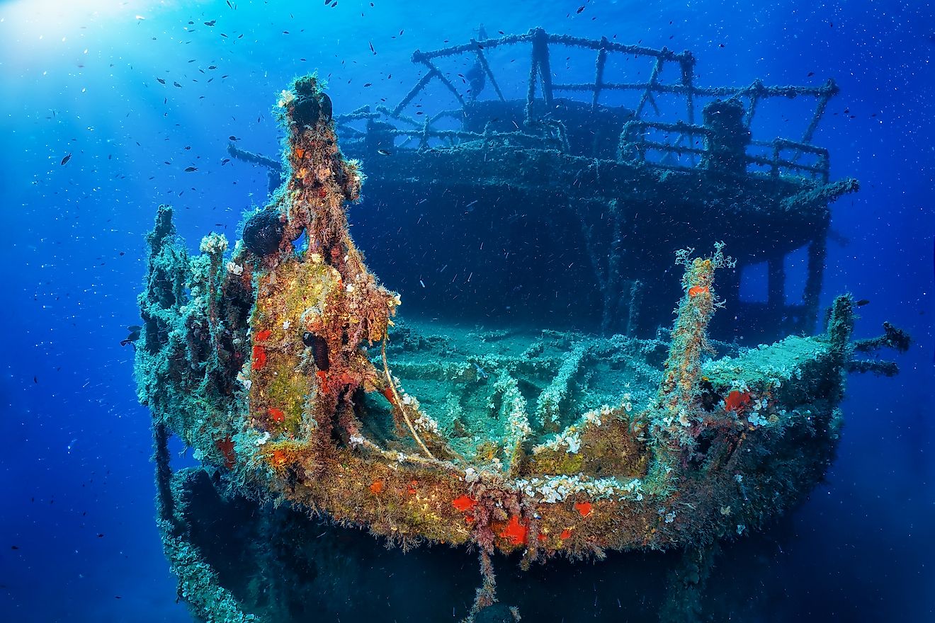
Lake George is a 45-square-mile body of water, with a maximum depth of about 196 feet and a maximum length of roughly 32 miles. Part of the reason for its popularity is how clean the water is. It has a Class AA-Special designation from New York, reflecting its high water quality and suitability for drinking-water use, swimming, and recreation. One popular activity in Lake George is diving beneath its waters to see historic shipwrecks, including vessels associated with the Sunken Fleet of 1758, or parasailing above the surface of the lake.
Lake Champlain

Lake Champlain stretches from Quebec into the border region between New York and Vermont. It covers about 435 square miles and has an average depth of about 64 feet, with a maximum depth of around 400 feet. Burlington, Vermont, and Plattsburgh, New York, are among the largest communities on its shores, and both are popular spots for walking, boating, and other water activities. Birding also accounts for many of its photos, with more than 300 species of birds recorded around Lake Champlain, including the Common Tern.

As a freshwater lake, it provides drinking water for around 200,000 people, along with recreational access to beaches and 71 islands. Grand Isle is the largest of these islands. It sits in northwestern Vermont and is home to just under 3,700 people.
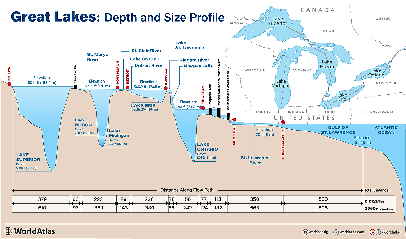
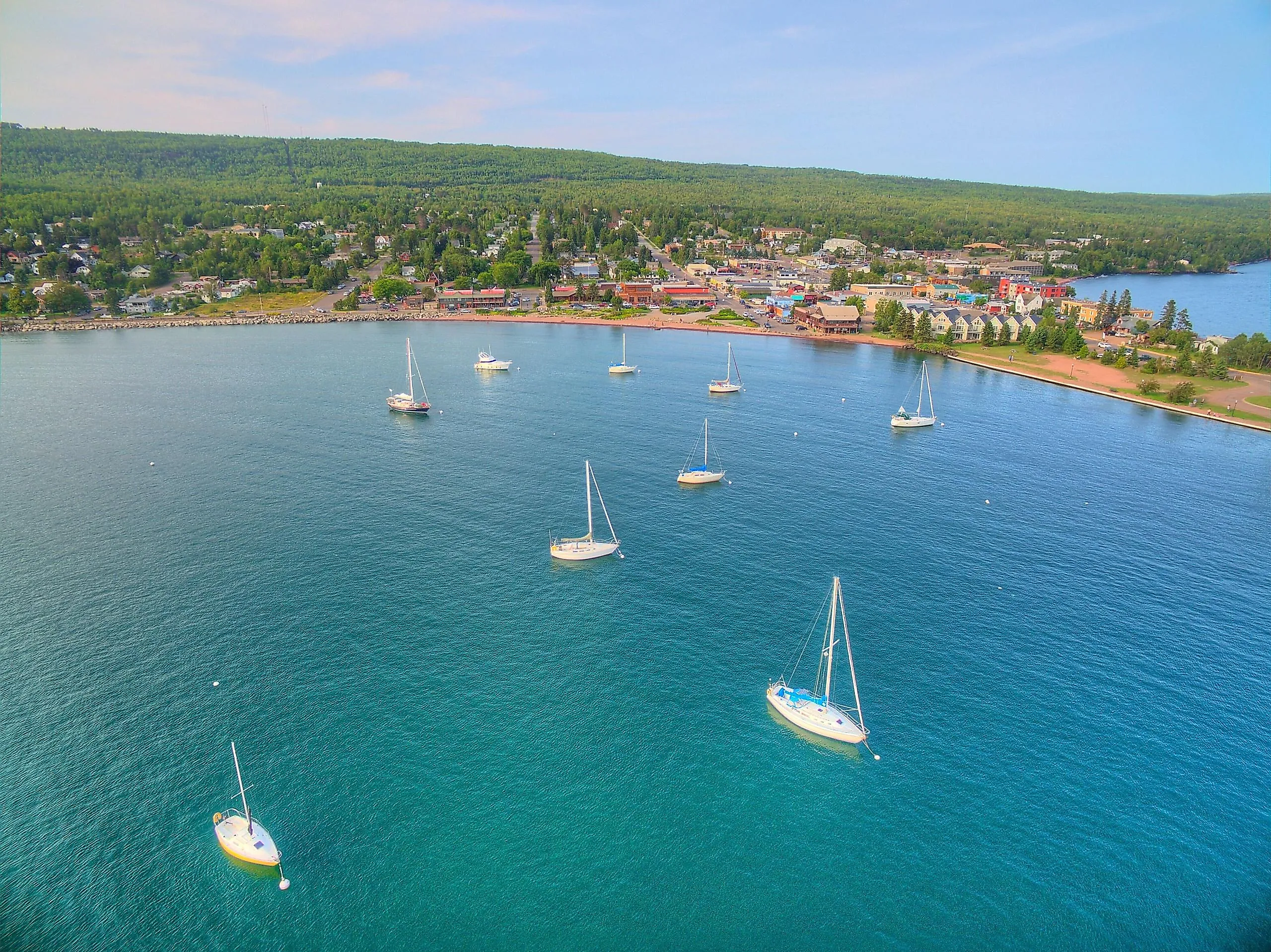
Lake Superior

Lake Superior breaks many records. It is the largest of the Great Lakes and the largest freshwater lake in the world by surface area, covering about 31,700 square miles. It also holds roughly 10% of the world’s fresh surface water. The lake reaches a maximum depth of about 1,300 feet.

Lake Superior is the least developed of the Great Lakes, with a wild coastline and a relatively small population compared with the other Great Lakes. Visitors come to see rugged shoreline, cold clear water, and protected areas such as Apostle Islands National Lakeshore, which includes 21 islands and 12 miles of mainland shoreline.
Lake Michigan

Lake Michigan is the third-largest of the Great Lakes by surface area and the second-largest by volume, with a water surface area of 22,300 square miles and a maximum depth of 923 feet. It is the only one of the Great Lakes contained entirely within the United States, and it connects to Lake Huron through the Straits of Mackinac. The Mackinac Bridge spans these straits, connecting the Lower and Upper peninsulas of the state of Michigan.

The lake’s shoreline is home to major population centers, including the Chicago metropolitan area. One of its defining features is the vast number of freshwater sand dunes along its shores. The Lake Michigan shoreline contains the largest collection of freshwater coastal dunes in the world, including major dune landscapes in Michigan and the towering dunes of Indiana Dunes National Park. This park also supports several delicate environments, such as Cowles Bog, containing ponds, marshes, and black oak savannas.
Lake Ontario

Lake Ontario is the smallest of the Great Lakes by surface area at 7,340 square miles. It is the final lake in the Great Lakes chain before water flows into the St. Lawrence River and toward the Atlantic Ocean. Its watershed is home to millions of people and supports a major share of Canada’s population. The lake borders New York and Ontario, Canada.

One of the lake's most visited parks is Chimney Bluffs State Park, named after clay formations that were eroded by wind, rain, snow, and lake water into shapes that resemble chimneys. Boaters also go out onto the lake and nearby waterways to reach the Thousand Islands, an archipelago of more than 1,800 islands in the St. Lawrence River region.
Lake Erie

Lake Erie is both the shallowest and warmest of the Great Lakes, with an average depth of 62 feet and a maximum depth of 210 feet. It has a surface area of 9,910 square miles and borders four U.S. states: New York, Pennsylvania, Ohio, and Michigan, along with Ontario, Canada. Visitors come to enjoy its warm beaches and popular attractions, such as Cedar Point amusement park, located on a Lake Erie peninsula in Ohio.

One of the lake’s most dramatic outlets is the Niagara River, which carries water from Lake Erie toward Lake Ontario. Along the way, the river plunges over Niagara Falls. With a drop of more than 164 feet, Niagara Falls is one of the most famous waterfalls in the world and the largest waterfall in North America by flow volume.
Yellowstone Lake

Yellowstone Lake sits in the Wyoming section of Yellowstone National Park. It is the largest high-elevation lake in North America, sitting at 7,733 feet above sea level with a surface area of 132 square miles. The lake also supports the largest inland population of Yellowstone cutthroat trout in North America. Scientists believe the trout reached the lake through ancient drainage connections near Two Ocean Pass and the Snake River system.

The lake freezes over completely each winter, thawing in May or June. Due to its high elevation, the lake’s average water temperature is around 41 degrees Fahrenheit annually.
Crater Lake

Crater Lake is a striking body of water in southern Oregon. Sitting within a volcanic caldera, it is the deepest lake in the United States and one of the deepest lakes in the world, reaching about 1,943 feet deep. Its clear blue waters make it among the most recognizable lakes in the country.

One reason for this blue color is that the lake gets its water almost entirely from snow and rain that fall at its high elevation of about 6,178 feet above sea level. There are no rivers or streams that flow into it, which helps keep the lake free from sediment and many pollutants. The lake was formed after Mount Mazama erupted and collapsed about 7,700 years ago, leaving behind a caldera that was gradually filled with water.
Big populations, and hidden lakes
Some of these lakes support large populations with drinking water, recreation, and shoreline communities, such as the vast Lake Michigan and Lake Ontario, while others sit high in the mountains, such as Yellowstone Lake in the Rocky Mountains or Crater Lake in the Cascade Range of Oregon. Photographers may focus on the deep blue waters of the lakes themselves or the geological features around them, such as the chimney-shaped bluffs off the shore of Lake Ontario or the dunes of Lake Michigan. Together, these 9 lakes show the range of scenery that makes America’s lakes such enduring subjects for photography.