How Much Water Sits Behind America's 10 Biggest Dams
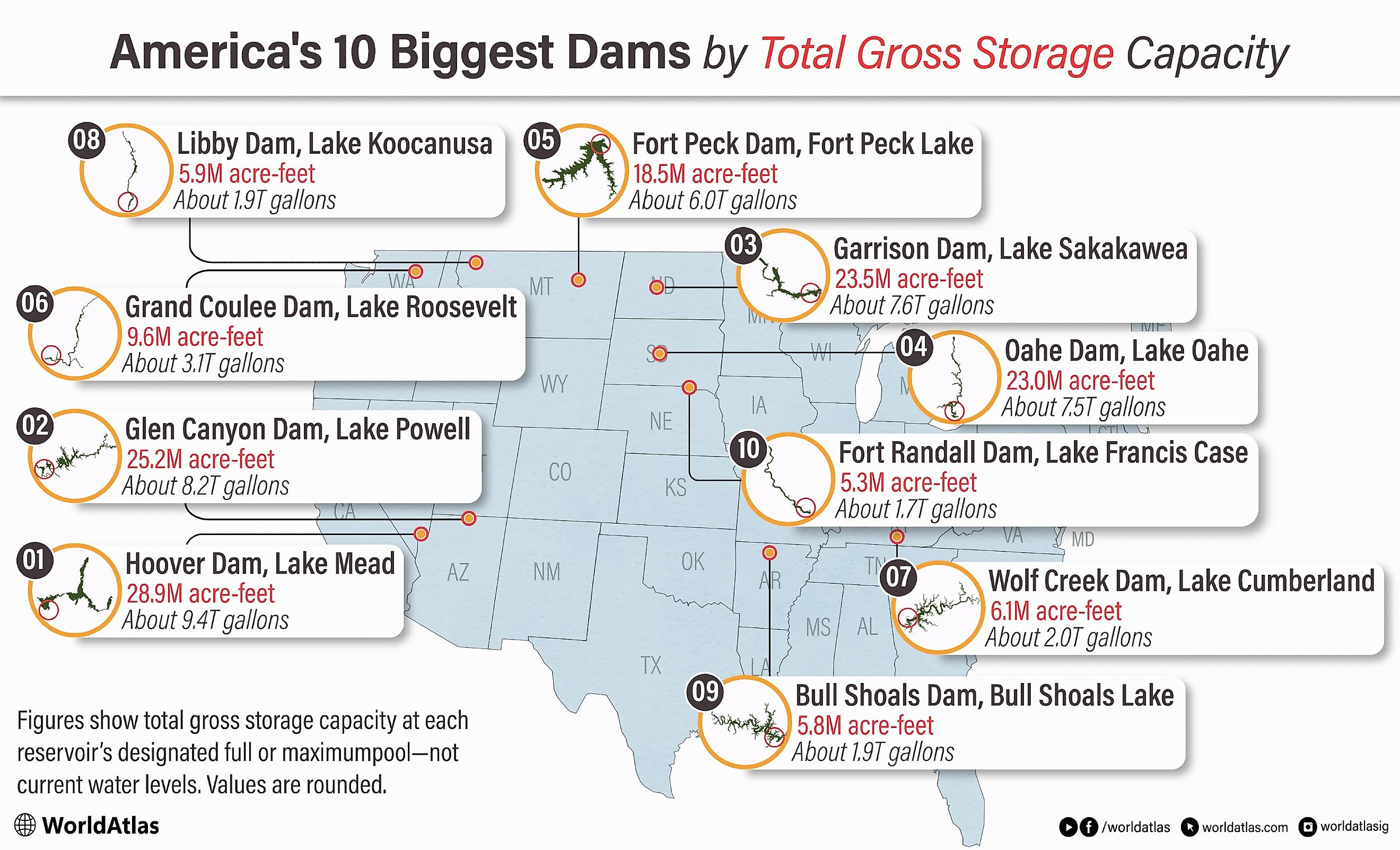
Picture nearly 9.4 trillion gallons of water sitting in the desert behind a single wall of concrete. That is Lake Mead at full pool, the biggest reservoir in the country, and it is only the leader of a heavyweight class. The ten dams below back up so much water that at their designated full pools they could bury Pennsylvania under nearly five feet of it. Capacity gets measured in acre-feet, and one acre-foot runs about 325,851 gallons, enough to flood an acre a foot deep. Here is how much water the ten biggest American dams can hold, counted down from the largest.
1. Hoover Dam, Nevada/Arizona

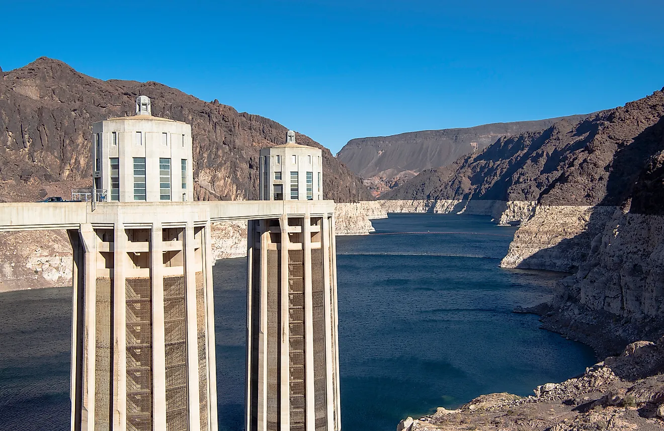
By total gross storage capacity, Lake Mead remains the country's largest reservoir at 28,945,000 acre-feet (35.7 km³) behind Hoover Dam on the Colorado River. Completed in 1936 on the Nevada-Arizona border, the 726-foot (221 m) concrete arch-gravity dam was, at the time, the tallest dam in the world, and it remains one of the most visited engineering landmarks in the United States.
Lake Mead's roughly 248-square-mile surface sits within the Lake Mead National Recreation Area. The reservoir supplies drinking water to some 25 million people across Nevada, Arizona, and California, along with irrigation water for millions of acres of farmland in the Southwest. Decades of drought and overuse across the Colorado River Basin have dropped the lake to a fraction of its full capacity in recent years, making it one of the US reservoirs closest to dead pool.
2. Glen Canyon Dam, Arizona

Standing 710 feet (216 m) tall on the Colorado River near the Arizona-Utah border, Glen Canyon Dam impounds Lake Powell, whose latest official total-capacity figure is 25,160,000 acre-feet (31.0 km³) at full pool. Reclamation has estimated the reservoir's highly irregular shoreline at approximately 1,960 miles when full. Lake Powell first reached full pool in 1980, about 17 years after the diversion tunnels closed and filling began.
Within the Glen Canyon National Recreation Area, the lake's turquoise waters are a magnet for houseboaters and kayakers exploring slot canyons like Antelope Canyon, while nearby Rainbow Bridge National Monument protects one of the world's largest natural stone bridges. Sustained drought and heavy water demand across the Colorado River Basin have pushed the reservoir to some of its lowest levels on record in recent years.
3. Garrison Dam, North Dakota

Garrison Dam is a 210-foot (64 m) earthen embankment on the Missouri River that impounds Lake Sakakawea, whose current maximum cumulative storage capacity is approximately 23,451,000 acre-feet (28.9 km³). Stretching about 178 miles across west-central North Dakota, Lake Sakakawea is one of the largest reservoirs in the United States and lies entirely within the state.
The reservoir's construction flooded much of the Fort Berthold Indian Reservation, displacing members of the Mandan, Hidatsa, and Arikara Nation from their traditional riverside communities. Today, Lake Sakakawea State Park sits on the lake's southern shore with beaches, campgrounds, and a marina, while the reservoir supports a major walleye fishery.
4. Oahe Dam, South Dakota

Constructed between 1948 and 1962, Oahe Dam rises 245 feet (75 m) above the Missouri River just north of Pierre, South Dakota. President John F. Kennedy dedicated the project in 1962. The dam impounds Lake Oahe, whose current maximum cumulative storage capacity is approximately 22,983,000 acre-feet (28.3 km³), making it the fourth-largest reservoir on this list. The reservoir stretches roughly 231 miles upstream into North Dakota.
Lake Oahe's 2,250 miles of shoreline support walleye and chinook salmon fisheries that draw anglers from across the northern Plains. The Oahe Downstream Recreation Area just below the dam offers camping, hiking, and boat access along the river. The reservoir also submerged large portions of the Standing Rock and Cheyenne River Sioux reservations when it was built, a history still felt in the region today.
5. Fort Peck Dam, Montana

Built between 1933 and 1940 on the Missouri River in the remote plains of northeastern Montana, Fort Peck Dam is the largest hydraulically filled dam in the United States. It holds back Fort Peck Lake, which stores 18,463,000 acre-feet (22.8 km³) of water across a 245,000-acre surface, making it the fifth-largest reservoir in the country. The dam and its Depression-era construction camps once housed tens of thousands of workers and were chronicled in some of the era's most famous photography.
The reservoir sits within the Charles M. Russell National Wildlife Refuge, a sprawling wilderness home to elk, bighorn sheep, and prairie wildlife. On its shore, the Fort Peck Interpretive Center and Museum displays "Peck's Rex," a nearly complete Tyrannosaurus rex skeleton unearthed nearby, alongside exhibits on the dam's construction.
6. Grand Coulee Dam, Washington

Grand Coulee Dam is a 550-foot (168 m) concrete gravity dam on the Columbia River in eastern Washington. Its original generating units entered service during the 1940s, and a later expansion was completed in the 1970s. The dam impounds Franklin D. Roosevelt Lake, commonly called Lake Roosevelt, which has a total storage capacity of approximately 9,562,000 acre-feet (11.8 km³) and extends roughly 150 miles upstream. Grand Coulee's generating complex has an installed capacity of approximately 6,809 megawatts, the most of any hydroelectric facility in the United States.
The reservoir falls within the Lake Roosevelt National Recreation Area, a nearly 100,000-acre swath of shoreline, canyons, and forest managed by the National Park Service that draws boaters, campers, and anglers chasing kokanee salmon and rainbow trout. Nearby, Steamboat Rock State Park offers a dramatic basalt monolith rising 800 feet above the lake.
7. Wolf Creek Dam, Kentucky

Wolf Creek Dam, a 258-foot (79 m) earthen and concrete dam on the Cumberland River in south-central Kentucky, was completed in 1952 and holds back Lake Cumberland, whose 6,089,000 acre-foot (7.5 km³) capacity makes it the largest reservoir by volume east of the Mississippi River. The Corps completed a major foundation seepage barrier in 2013 after years of work to reduce the risk posed by seepage through the dam's karst foundation.
Lake Cumberland's 101 square miles of surface area and more than 1,200 miles of shoreline have made it one of the Southeast's most popular houseboating destinations, ringed by marinas and the Lake Cumberland State Resort Park. Downstream on the same river system, Cumberland Falls State Resort Park is one of only a handful of places in the world where visitors can regularly see a moonbow, a rainbow formed by moonlight.
8. Libby Dam, Montana

Standing 422 feet (129 m) tall on the Kootenai River in northwestern Montana, Libby Dam was completed in 1973 and impounds Lake Koocanusa, whose total storage capacity is 5,869,000 acre-feet (7.2 km³). The often-cited figure of approximately 4,980,000 acre-feet refers to usable storage rather than the reservoir's total capacity. The reservoir's name combines "Kootenai," "Canada," and "USA" in recognition of its binational reach. About 42 miles of the 90-mile reservoir back up across the border into British Columbia, and the rest lies in Montana.
The dam and lake sit within the Kootenai National Forest, an expanse of dense conifer forest and jagged peaks that draws anglers after kokanee salmon and rainbow trout, along with hikers and campers exploring the surrounding wilderness. The Libby Dam Visitor Center, perched atop the dam, offers views down the Kootenai River valley and exhibits on the dam's construction.
9. Bull Shoals Dam, Arkansas

Completed in 1951 on the White River in the Ozark Mountains, Bull Shoals Dam rises 256 feet (78 m) above the streambed and impounds Bull Shoals Lake, which has a total storage capacity of 5,760,000 acre-feet (7.1 km³) across the Arkansas-Missouri border. At its dedication in 1952, Bull Shoals was the fifth-largest concrete dam in the country.
The lake's 45,440-acre surface and roughly 740 miles of shoreline make it one of the most popular fishing and houseboating destinations in the Ozarks, with striped bass and walleye drawing anglers from across the region. The surrounding Bull Shoals-White River State Park offers hiking trails, campgrounds, and access to the White River's famed trout tailwaters below the dam.
10. Fort Randall Dam, South Dakota

Operating since 1953, Fort Randall Dam is a 165-foot (50 m) rolled-earth embankment on the Missouri River near Pickstown, South Dakota. It impounds Lake Francis Case, whose current US Army Corps of Engineers elevation-capacity data show a maximum cumulative storage capacity of approximately 5,293,000 acre-feet (6.5 km³). The dam was built as part of the Pick-Sloan Missouri Basin Program and began generating electricity in 1954.
Lake Francis Case stretches approximately 107 miles along the Missouri River and supports boating, fishing, and camping across several recreation areas. Immediately downstream, Randall Creek Recreation Area offers a boat ramp, campground, and fishing access along the river. The park's cottonwood trees also provide an important winter roosting area for bald eagles.
America's 10 Biggest Dams by Total Gross Storage Capacity
| Rank | Dam | Reservoir | Dam location | Capacity (acre-feet) | Capacity (km³) | Capacity (trillion gallons) |
|---|---|---|---|---|---|---|
| 1 | Hoover Dam | Lake Mead | Nevada/Arizona | 28,945,000 | 35.70 | 9.43 |
| 2 | Glen Canyon Dam | Lake Powell | Arizona | 25,160,000 | 31.03 | 8.20 |
| 3 | Garrison Dam | Lake Sakakawea | North Dakota | 23,451,300 | 28.93 | 7.64 |
| 4 | Oahe Dam | Lake Oahe | South Dakota | 22,982,900 | 28.35 | 7.49 |
| 5 | Fort Peck Dam | Fort Peck Lake | Montana | 18,462,840 | 22.77 | 6.02 |
| 6 | Grand Coulee Dam | Lake Roosevelt | Washington | 9,562,000 | 11.79 | 3.12 |
| 7 | Wolf Creek Dam | Lake Cumberland | Kentucky | 6,089,000 | 7.51 | 1.98 |
| 8 | Libby Dam | Lake Koocanusa | Montana | 5,869,000 | 7.24 | 1.91 |
| 9 | Bull Shoals Dam | Bull Shoals Lake | Arkansas | 5,760,000 | 7.10 | 1.88 |
| 10 | Fort Randall Dam | Lake Francis Case | South Dakota | 5,293,473 | 6.53 | 1.72 |
| Combined capacity | 151,575,513 | 186.97 | 49.39 |
(Capacity figures represent total gross storage at each reservoir's designated full or maximum pool. Actual water levels vary throughout the year.)
The Rivers Behind America's Water Supply
Between the sandstone canyons of Lake Powell and the prairie wilderness ringing Fort Peck Lake, these ten reservoirs reveal just how much of America's drinking water, farmland, and electricity depends on a handful of massive dams. Most were built within a few decades of one another, during an era when the federal government raced to tame the country's largest rivers. At their designated full or maximum pools, the ten reservoirs could collectively store approximately 151.6 million acre-feet of water, although their actual contents vary and may be far below that figure. Before planning a trip to any of these reservoirs, it is worth checking current water levels, as drought has left several well below their listed capacities.