The Largest Alpine Lakes In North America
Tectonic faulting, volcanic collapse and glacial carving have formed massive alpine lakes across the highest altitude regions of North America. Most are fed almost entirely by glacial melt and snowmelt. An alpine lake has no strict definition but generally sits above 5,000 feet (1,524 meters) in a cold climate.
Freezing winter temperatures lock their surface waters under ice sheets for months at a time, creating unique aquatic habitats, driving regional ice-fishing tourism, and preserving critical winter snowpack for major downstream river basins.
Ranked by surface area, these 10 largest alpine lakes in North America combined span about 570 square miles (1,476 square kilometers).
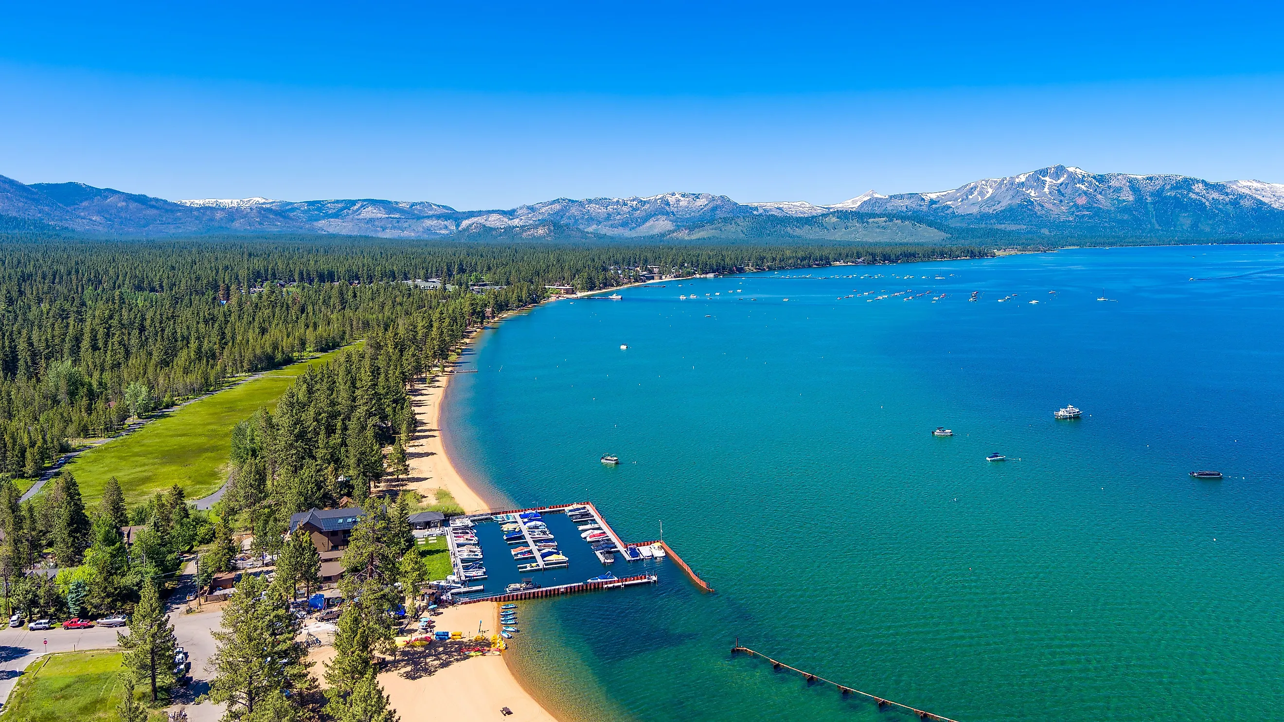
Lake Tahoe, California and Nevada

Straddling the border between California and Nevada in the Sierra Nevada mountain range, Lake Tahoe sits at an elevation of 6,225 feet (1,897 meters). With a surface area of 192 square miles (497 square kilometers), it ranks as the largest high-altitude freshwater lake in the United States by volume, holding an estimated 39 trillion gallons (150 cubic kilometers) of water. Faulting along the Carson Range created the basin about two million years ago.
Lake Tahoe reaches a maximum depth of 1,645 feet (501 meters), making it the second-deepest lake in the United States after Crater Lake. The water clarity in Lake Tahoe stems from the fact that 40 percent of the precipitation falling into the basin lands directly onto the lake surface, while the remaining watershed consists primarily of resistant granite rock that produces minimal fine sediment and is filtered through marshes and meadows. The Truckee River serves as the lake's sole outlet, flowing northeast into Pyramid Lake.
Yellowstone Lake, Wyoming

Situated high in the Rocky Mountains at 7,733 feet (2,360 meters) above sea level, Yellowstone Lake covers 132 square miles (342 square kilometers) within Yellowstone National Park. It is the largest high-elevation body of water in North America situated above 7,000 feet (2,134 meters). The lake occupies the southeastern portion of the Yellowstone Caldera, a volcanic feature formed during a massive eruption roughly 640,000 years ago.
The lake has 110 miles (177 kilometers) of shoreline and freezes completely in the winter, holding a layer of ice of over two feet (0.6 meters) thick from December through May.
Geological research beginning in 1984 revealed underwater hot springs, geysers, and massive silicate spires rising up to 20 feet (six meters) off the lakebed. With a submersible robot, the researchers discovered a canyon east of Stevenson Island that measured 390 feet (119 meters) deep, breaking the earlier deepest recorded depth of 320 feet (97.5 meters). Scientists also recorded water temperatures reaching 252 degrees Fahrenheit (122 degrees Celsius) at submerged hydrothermal vents, proving that volcanic systems actively shape the aquatic environment from below.
Bear Lake, Idaho and Utah

Located on the border between southeastern Idaho and northeastern Utah, Bear Lake covers 109 square miles (282 square kilometers) at an elevation of 5,924 feet (1,806 meters). Fault-line movement formed this deep graben valley over 250,000 years ago, making Bear Lake one of the oldest lakes in North America.
The lake freezes over approximately every seven out of 10 winters, developing an ice sheet from January through April that draws ice fishers targeting the endemic Bonneville cisco (Prosopium gemmifer). In some places the ice can reach up to three feet thick. In addition to the cisco, the ecosystem harbors three other endemic fish species found nowhere else. These are the Bear Lake whitefish (Prosopium abyssicola), Bonneville whitefish (Prosopium spilonotus), and Bear Lake sculpin (Cottus extensus).
In the warmer months, suspended calcium carbonate minerals in the water scatter sunlight, giving the lake its intense turquoise color. Its unique mineral chemistry originates from western springs seeping through limestone formations.
Jackson Lake, Wyoming

Jackson Lake sits at the base of the Teton Range inside Grand Teton National Park at an elevation of 6,776 feet (2,064 meters). Glaciers carved the original natural basin, which was expanded by Jackson Lake Dam to reach a surface area of 40 square miles (104 square kilometers).
Cold air trapped in the Jackson Hole valley causes the lake to freeze solid every December. Ice cover remains until May, often reaching depths of two to three feet (0.6 to 0.9 meters). The Snake River flows directly through Jackson Lake, bringing cold glacial meltwater that feeds populations of lake trout (Salvelinus namaycush) and Snake River fine-spotted cutthroat trout (Oncorhynchus clarkii behnkei).
This icy influx holds high dissolved oxygen levels and keeps deep lake waters below 55 degrees Fahrenheit (13 degrees Celsius), protecting both species from summer thermal stress. By maintaining a cold, oxygen-rich environment, the meltwater also preserves essential spawning tributaries where fry can safely mature.
Strawberry Reservoir, Utah

Located in the Strawberry Valley of north-central Utah, Strawberry Reservoir covers 23 square miles (61 square kilometers) at an elevation of 7,602 feet (2,317 meters). Constructed as part of the Strawberry Valley Project, it impounds the Strawberry River to provide irrigation and municipal water storage for the Utah Valley.
Because of its high elevation and exposed mountain valley, winter ice freezes the reservoir from mid-December through mid-April. Strawberry Reservoir represents Utah's premier cold-water fishery, supporting trophy Bear Lake cutthroat trout (Oncorhynchus clarkii utah) and rainbow trout (Oncorhynchus mykiss) that thrive beneath the winter ice cap. Abundant submerged vegetation and high populations of Utah chub support a food web that fuels rapid growth rates for these game fish. As open water returns in late spring, anglers visit these cold snowmelt tributaries targeting trout feeding near the surface, cementing the reservoir's status as a year-round recreation area.
Crater Lake, Oregon

Perched high in the Cascade Range of southwestern Oregon at 6,178 feet (1,883 meters), Crater Lake rests inside a volcanic caldera formed roughly 7,700 years ago when Mount Mazama collapsed during a violent eruption. While its surface area of 20.6 square miles (53.3 square kilometers) is modest compared to broad tectonic basins, Crater Lake holds substantial water volume, about 4.3 trillion gallons, due to its extreme depth.
Crater Lake is the deepest lake in the United States at 1,949 feet (594 meters). Because the caldera walls isolate the lake from outside rivers or streams, all water entering the basin comes directly from precipitation and snowmelt. The absence of river sediment leaves the water exceptionally clear, allowing sunlight to penetrate deep into the water column and scattering blue wavelengths to create its deep blue color. Secchi disk measurements regularly record clarity depths of over 100 feet (30 meters).
Despite receiving over 40 feet of snow each year, the lake rarely freezes over completely because its vast depth stores heat and keeps the water continuously mixing. Its water levels also remain remarkably stable, as heavy precipitation naturally balances out what is lost to evaporation and seepage through the porous volcanic rock.
Hebgen Lake, Montana

Hebgen Lake sits in southwestern Montana at an elevation of 6,500 feet (1,981 meters), covering 20 square miles (52 square kilometers). The lake formed when Hebgen Dam impounded the Madison River in 1914. In 1959, a magnitude 7.3 earthquake struck the area, causing the lakebed to drop over 10 feet (3 meters) in seconds and generating large wave surges across its surface.
High-elevation winter weather causes Hebgen Lake to freeze completely from December through April. Cold water flowing in from the Madison River maintains high dissolved oxygen levels year-round, supporting rich insect hatches of midges and mayflies that sustain wild brown trout (Salmo trutta) and rainbow trout.
Due to a 1959 earthquake, the tilted lakebed created extensive shallow mud flats along the northern shore and submerged old stream channels that now act as rich aquatic nurseries. During peak summer Callibaetis and Trico mayfly hatches, massive wild trout cruise these shallows, earning the lake international renown as a premier "gulper" fishery where large trout audibly sip insects directly off the calm surface.
Shoshone Lake, Wyoming

Shoshone Lake sits at an elevation of 7,795 feet (2,376 meters) in the southwestern region of Yellowstone National Park. Spanning 12.6 square miles (32.6 square kilometers), it holds the distinction of being the largest backcountry lake in the contiguous United States that lacks road access. Glacial ice carved the basin, which remains isolated from major development. Winter conditions freeze the entire lake surface from December through late May.
Reaching Shoshone Lake requires either a multi-mile hike, most commonly the roughly six-mile (9.7-kilometer) round trip on the DeLacy Creek Trail, or a paddle across Lewis Lake followed by a push upstream through the Lewis River Channel, since no road touches its shore.
That isolation preserves the Shoshone Geyser Basin on the lake's southwest end, one of the densest geyser fields on Earth, packing more than 80 geysers and hot springs into an area measuring about 1,600 by 800 feet (488 by 244 meters). The basin can only be reached on foot or by boat, and its thermal features vent steam through the ice even when the lake itself is frozen solid.
Lake Granby, Colorado

Lake Granby rests in Grand County, Colorado, at an elevation of 8,280 feet (2,524 meters). With a surface area of 11.3 square miles (29.3 square kilometers), it is the third-largest body of water in Colorado. Built as part of the Colorado-Big Thompson Project, the lake stores upper Colorado River water before pumping it through the Continental Divide to the Rocky Mountain Front Range. The reservoir holds 539,758 acre-feet at capacity and has about 40 miles (64 kilometers) of shoreline. The yacht club on its surface ranks among the highest-elevation sailing clubs in the world.
Cold mountain air at over 8,000 feet freezes the surface solid by early January, maintaining an ice sheet through April. Lake Granby contains deep, cold waters that support kokanee salmon (Oncorhynchus nerka) and large lake trout, attracting winter ice anglers to the basin.
Lewis Lake, Wyoming

Lewis Lake covers 10.5 square miles (27 square kilometers) in southern Yellowstone National Park at an elevation of 7,782 feet (2,372 meters). Positioned just south of Shoshone Lake along the Lewis River channel, the lake basin sits within the Pitchstone Plateau volcanic region.
Lewis Lake held no fish at all until 1890, when the U.S. Fish Commission stocked it and neighboring Shoshone Lake with lake trout hauled in from Lake Michigan, since the 30-foot drop of Lewis Falls downstream had always blocked native cutthroat trout from reaching the basin naturally. That decision had consequences far beyond Lewis Lake itself. Researchers later traced lake trout found in Yellowstone Lake, first caught by an angler in 1994, back to fish that originated in Lewis Lake, most likely introduced by someone who moved them between watersheds.
The National Park Service has run an aggressive gillnetting program on Yellowstone Lake for years since to suppress the resulting lake trout population, which preys on native cutthroat trout. Warm springs still feed into Lewis Lake along its northwestern shore and near its outlet, creating patches of open water even as the rest of the lake ices over for the winter.
North America's Largest Alpine Lakes
These 10 water bodies demonstrate how geological forces and extreme winter climates shape the high-elevation landscapes of North America. From volcanic calderas in the Cascade and Rocky Mountains to fault-block valleys across the Great Basin and the Wasatch Range, each basin accumulates cold snowmelt and sustains winter ice cover that defines local ecosystems.
Beyond their geographic scale, these high-altitude lakes continue to serve as vital freshwater reservoirs, winter recreational destinations, and habitats for native cold-water species across the continent.