Geography Of The World
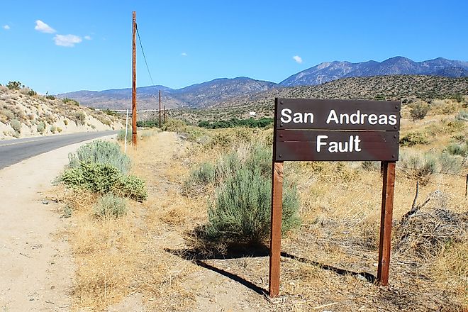
San Andreas Fault
San Andreas Fault is a major continental transform boundary that is situated in the extreme western part of the continent of North America.
British Empire
The British Empire was the largest empire in human history. It consisted of the colonial possessions of what is now the United Kingdom of Great Britain and Northern Ireland.

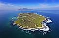
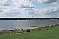
Robben Island
Robben Island is an island in the Atlantic Ocean in Table Bay, approximately 7 kilometers west of the mainland and 10 kilometers north of Cape Town.
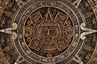
Aztec Empire
According to Aztec legend, they came from a place called Aztlán, thought to be somewhere in present-day northern Mexico.
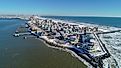
Absecon Island
Absecon Island is a barrier island along the Jersey Shore of the Atlantic Ocean, off the coast of New Jersey, United States of America.
Russian Empire
The Russian Empire was a vast empire that once spanned large parts of Europe and Asia. It began in the 13th century as the small principality of Moscow.

Dauphin Island, Alabama
Dauphin Island is one of the barrier islands in the Gulf Coast, off the coast of Alabama, in the United States. The island itself is in the outer part of Mobile Bay.
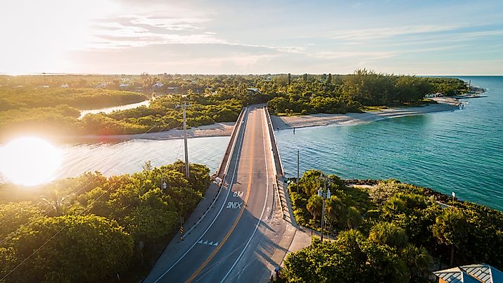
Captiva Island
Captiva Island, sister to the larger Sanibel Island, is located off the southwest coast of Florida, United States. Just south of Cayo Costa and west of Cape Coral and Pine Island/
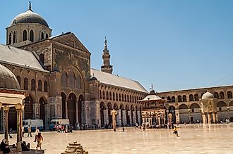
Umayyad Caliphate
The Umayyad Caliphate was an Islamic Empire that ruled North Africa, the Middle East, and even significant parts of Europe and the Indian Subcontinent.

Spanish Empire
The Spanish Empire, controlled by the Kingdom of Spain, endured from the 15th century all the way into the 20th century.
Saipan Island
Saipan Island sits within the-15 tropical islands chain, the Marianas archipelago, with a total area of 115.39 sq.km and the population nearing 70,000.

Mali Empire
The Mali Empire was a large empire in West Africa. It rose from the ashes of the Ghana Empire (not to be confused with the modern country of Ghana).
Lake Minnewanka
Lake Minnewanka is a glacial lake located just outside the town of Banff, in Alberta, Canada. The lake has a surface area of 22 square kilometers.
Caminito del Rey
El Caminito del Rey is a 3km long and 1m wide walkway that is situated more than 100m above the Guadalhorce River in Spain.
Angels Landing
Formerly referred to as the “Temple of Aeolus”, Angels Landing is a unique natural rock formation that is situated in the Zion National Park.
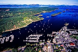
Salt Spring Island
Salt Spring Island is one of the large Gulf Islands situated in the Strait of Georgia of the Salish Sea between British Columbia and Vancouver Island.
Old Faithful Geyser
Geysers are transient geological features that periodically eject jets of steam and a column of hot water. They are usually found close to active volcanic areas.
Kuril Islands
The Kuril Islands is an island group in the Russian Far East that forms the boundary between the Pacific Ocean and the Sea of Okhotsk.
Cultus Lake, British Columbia
Cultus Lake is located in the Fraser Valley area of British Columbia. The lake has a surface area of 6.3 km2 and is the source of the Sweltzer River.
Cataract Canyon
Cataract Canyon is a 74km long canyon formed by the mighty Colorado River in the southern part of the US State of Utah.
Glenwood Canyon
Glenwood Canyon is a 20km rugged canyon situated in the west-central part of the US State of Colorado.
Abraham Lake
Abraham Lake is a reservoir, or artificial lake, located in western Alberta, Canada. It sits in the Kootenay Plains area of the Canadian Rocky Mountains.
Edisto Island
Edisto Island is one of the Sea Islands situated in the US State of South Carolina, approximately 68km to the southwest of the city of Charleston.
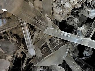
Cave Of The Crystals
The Giant Crystal Cave, also known as the Cave of the Crystals, is a horse-shaped cave beneath the Sierra de Naica in Chihuahua, Mexico.
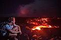
Kilauea
The shield volcano is located in the southeastern part of Mauna Loa and is the main attraction of the Hawaii Volcano National Park.
New River (Mexico–United States)
New River is a river in North America that flows north from Cerro Prieto, Mexico, into the Salton Sea in Imperial County, California, United States.
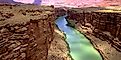
Marble Canyon
Marble Canyon is located in northern Arizona and is part of the much larger Colorado River canyon. It forms a natural western boundary for the Navajo Nation.
Guadalupe River, Texas
The Guadalupe River is a 370km long river that originates in the western portion of Kerr County in the US State of Texas.
Imperial Valley
The Imperial Valley is an extensively irrigated area in California, located between the Riverside and Imperial Counties.
Agawa Canyon
The Agawa canyon is a naturally occurring shallow canyon in Ontario, Canada. The canyon sits in the Algoma District.
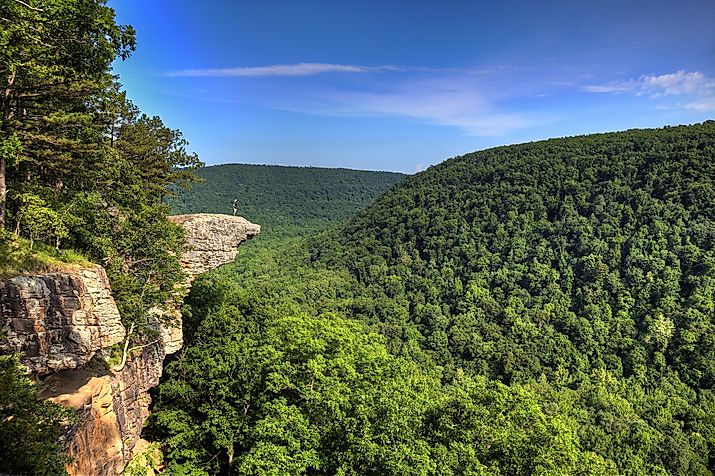
Ozark Mountains
The Ozark Mountains, also known as the Ozark Plateaus or simply as Ozarks, are a highland region in the south-central United States.
Grand Lake, Colorado
Grand Lake is the biggest and deepest natural water body that is situated in Grand County, in the north-central part of the US State of Colorado.
Wells Gray Park Cave Discovery
The Wells Gray Park Cave discovery was the discovery of a karst cave in the remote area of British Columbia’s Wells Gray Provincial Park in 2018.
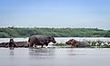
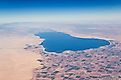
Lake Albert, Africa
Lake Albert, also known as Lake Nyanza and formerly called Lake Mobutu Sese Seko or Lake Mwitanzige, is Africa’s 7th largest lake.
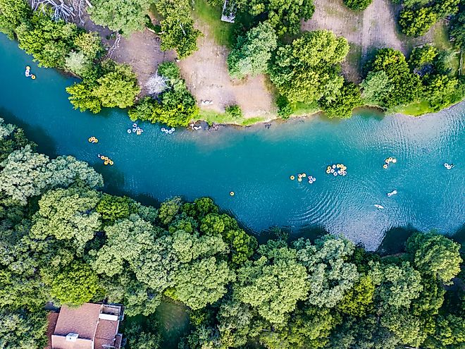
Garonne River
Garonne River is a transboundary river that rises in Spain’s Central Pyrenees and flows through southwestern France before emptying into the Atlantic Ocean.
Lake Athabasca
Lake Athabasca is a glacial lake in Canada straddling the Saskatchewan-Alberta border, just south of the Northwest Territories.
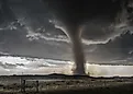
Tornado Alley
Tornado Alley refers to a region in the central United States frequented by tornadoes. In this area, a tornado occurs when the moist air from the Gulf of Mexico meets the dry cold air from Canada.