Imperial Valley
The Imperial Valley, also known as the Salton Trough or Salton Sink, is an extensively irrigated area in California, located between the Riverside and Imperial Counties. It is one of California’s major producers of broccoli, potatoes, spinach, onion, sweet corns, and cauliflower. The Valley was named “Imperial Valley” towards the beginning of the 21st century by land investors known as the Imperial Land Company. The area is now the location for El Centro metropolitan area. The Mexicali Valley lies south of the “South Border” (south of the Imperial Valley)
Geography Of The Imperial Valley

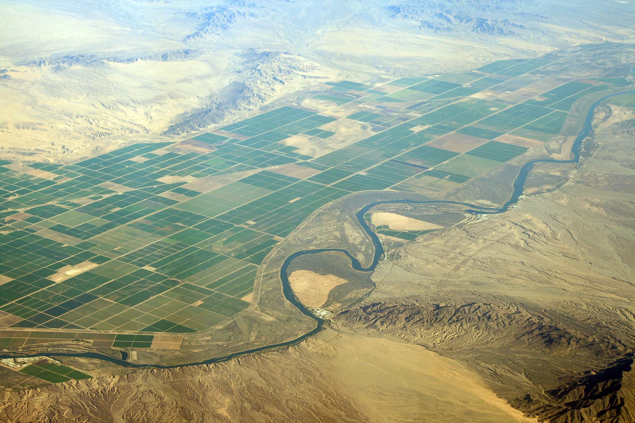
The Imperial Valley is part of the California Desert located in southern California’s counties of Riverside and Imperial. It forms part of the Gulf of California, extending southwards for about 80 kilometers from the saline Salton Sea into Baja California, Mexico. The Imperial Valley, Riverside County, and Imperial County form the Salton Sink (Trough). The Colorado River borders the Valley on the east, while the Salton Sea is on the west. The Coachella Valley is to the north. The Valley's portion at the edge of the Salton Sea is located almost entirely 72 meters below sea level.
The Imperial Valley was an extension of the Gulf of California until it was cut off from the Gulf by deposits from the Colorado River Delta’s fan. Barren mountains and dunes surrounded the Valley, making it difficult to access and inhabit. In 1901, the Imperial (Alamo) Canal diverted part of the Colorado River into the Imperial Valley to provide water for irrigation. However, the irrigation channels were destroyed by the 1905-1907 floodwaters that also formed the saline Salton Sea.
Climate

As part of the Colorado Desert, the Imperial Valley experiences a hot desert climate. Temperatures are extremely high, reaching over 38 degrees Celsius during summer. However, the temperatures are unusually mild from late October to mid-April. The Valley receives the most sunlight in the US during winter, averaging over 8 hours of sunlight daily. The area also receives low rainfall of about 74 millimeters annually. The Valley has not received snow for almost nine decades now, with the last snowfall recorded on December 12, 1932.
Demographics Of The Imperial Valley
The Imperial Valley is mainly located in Imperial County, which has a population of about 180,000 people. The main population centers in the area are El Centro, Brawley, Imperial, and Calexico. El Centro is the largest city in the Valley, with about 44,000 people. However, the El Centro metropolitan area has about 175,000 residents. Calexico, located on the Mexican border, is the second-largest city with 39,000 residents, while Brawley is home to 26,400 people. Other large towns in the Imperial Valley are Westmoreland, Calipatria, and Holtville.
Economy Of The Imperial Valley

The economy of the Imperial Valley agriculture and boasts about 2000 square kilometers of cultivated land and about 5,000 kilometers of irrigation canals. The Colorado River supplies the valley with irrigation water through the 132-km-long All-American Canal. The Valley produces cotton, alfalfa, spinach, cauliflower, sugar beets, broccoli, potatoes, and onions. Agriculture accounts for about 48% of the workforce in the Imperial Valley.

Retail trade and tourism are also major industries in the Imperial Valley and County, with many tourists coming to the area to explore the Salton Sea and Algodones Dunes. Other attractions include Blue Angles, Fort Yuma, Salton Sea volcanoes and mud pots, Salvation Mountain, Colorado River, and Imperial National Wildlife Refuge. The Valley is also a major source of renewable energy because of available sun resources, large tracts of unused land, and its proximity to major cities. The area generates geothermal and solar energies and is part of California’s plan to produce 33% of its energy from renewable sources.


