10 Deepest Canyons In The World
Also referred to as a gorge, a canyon refers to a steep-walled, deep V-shaped valley formed due to the weathering and erosive activities of a river flowing through the resistant rocks over geologic timescales. The word "canyon" has been derived from the Spanish word "canon," which means "pipe" or "tube." In North America, the term "canyon" is used, whereas the terms "gorge" and "ravine" are popular in European countries and Oceania. There are several different types of canyons in the world, such as box canyon, mountain-type canyon, slot canyon, and submarine canyon.
The deepest canyon in the world is the Yarling Tsangpo Canyon in China, followed by the Kali Gandaki Gorge in Nepal and the Indus River Gorge in Pakistan.
10. Tara River Canyon, Montenegro - 1,300 m (4,260 ft)

Also referred to as the Tara River Gorge, the Tara River Canyon is Europe’s biggest and deepest canyon. It stretches for more than 51 miles from Montenegro’s Bistrica to the village of Hum in Bosnia and Herzegovina. The canyon is characterized by over 80 massive caves, sandy beaches, high cliffs, and rocky and pebbly terraces. The high rocks of the Ljubisnja mountain range that are placed within the Durmitor National Park are the most attractive section of the Tara River Canyon. Within the Durmitor National Park, the Tara River, which becomes the Drina River after meeting with the Piva River close to Hum, contains a number of cascades that offer whitewater rafting opportunities.
9. Copper Canyon, Mexico - 1,600 m (5,250 ft)

Also known as "Barrancas del Cobre" in Spanish, the Copper Canyon refers to a group of six different canyons that are located in northwestern Mexico’s Sierra Madre Occidental in the southwestern portion of the Mexican state of Chihuahua. Ranging about 25,000 mi2 in size, this group of canyons was formed by six rivers that flow in the western portion of Sierra Tarahumara. All these rivers join the Fuerte River and finally drain into the Gulf of California. The Copper Canyon can be explored by hiking, horseback riding, biking, driving, or by the Chihuahua-Pacific Railway.
The mountainous regions of the Copper Canyon experience an alpine climate with moderate temperatures from March to April and October to November. Droughts are quite common during the warmest months, with scant rainfall until the beginning of the rainy season. Numerous pine and oak species cover the Sierra Tarahumara Occidental region, while wildflowers blossom in the upper regions after the rainy season. Currently, deforestation of several important floral species like Mesquite, Amapa, desert ironwood, etc., has endangered many wild species and led to the extinction of the Mexican wolf and imperial woodpecker. Moreover, the rapid rise in human population has also threatened the ecosystem of the Sierra Tarahumara Occidental region.
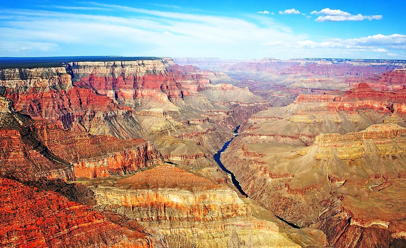
8. Grand Canyon, United States - 1,857 m (6,093 ft)

This 277-mile-long and 18-mile-wide steep-sided canyon has been carved by the continuous erosive activities of the Colorado River for thousands of years in the extreme northwestern corner of Arizona, United States. Reaching a maximum depth of 6,093 ft, the canyon’s wide, intricately carved chasm contains several buttes, peaks, gorges, and ravines. The Grand Canyon’s most beautiful and deepest segment is placed within the heart of the Grand Canyon National Park and extends from Lake Powell to Lake Mead for about 55.9 miles. The North Rim of the Grand Canyon is placed at an average elevation of 8,000 ft more than the South Rim, which is the Grand Canyon’s most visited part. Due to its higher elevation, the North Rim receives an average of 69cm of rainfall and 370cm of snowfall per year.
The Grand Canyon National Park supports about 195 species of lichen, 64 species of moss, 167 species of fungi, and 1,737 known vascular plant species. Several endemic plant species are also supported by the Grand Canyon within the National Park boundaries. More than 450 avian species, 48 reptilian species, 10 amphibian species, 91 mammalian species, and numerous invertebrate species are found in the Grand Canyon area. On January 11, 1908, the Grand Canyon was designated a National Monument by US President Theodore Roosevelt.
7. Hells Canyon, United States - 2,400 m (7,900 ft)
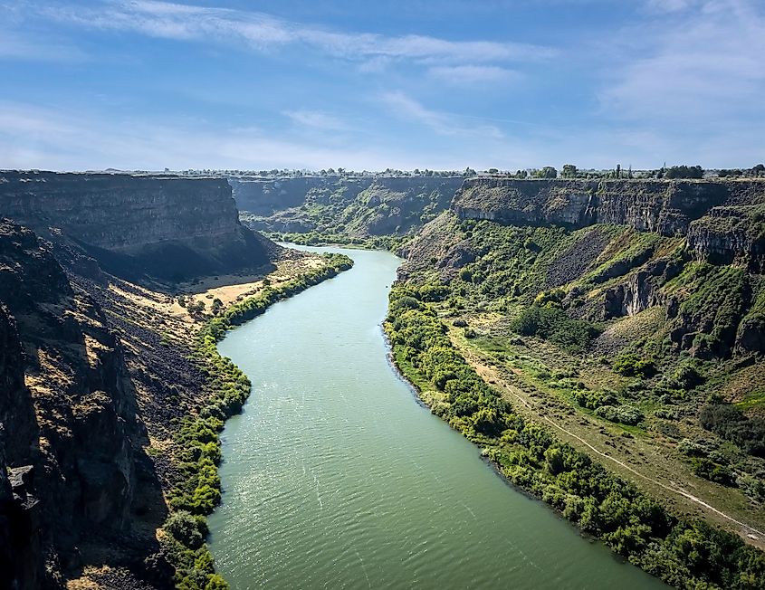
Hells Canyon is a gorge of the Snake River along the Idaho-Oregon border, spanning 125 miles, with 40 miles more than a mile deep. Reaching 7,900 feet at its greatest depth, it is North America’s deepest gorge. The walls display yellow, red, and orange hues, rising dramatically in places. After debate over damming for flood control, Idaho Power Company built three dams, Brownlee, Oxbow, and Hells Canyon, between 1959 and 1968.
Established in 1975, Hells Canyon National Recreation Area covers 1,020 square miles within Wallowa-Whitman, Nezperce, and Payette national forests, and includes a designated wild and scenic portion of the Snake River.
6. Colca Canyon, Peru - 3,350 m (11,000 ft)
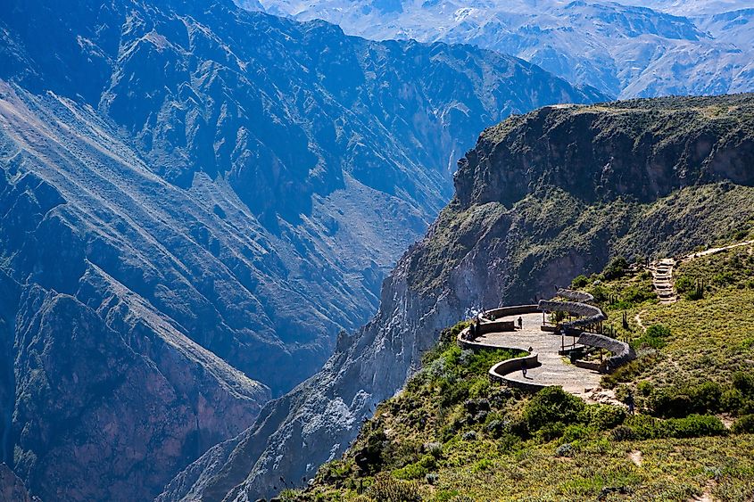
Formed by the Colca River, Colca Canyon is one of the world’s deepest canyons, situated approximately 99 miles northwest of the city of Arequipa in southern Peru. Placed in the colorful Colca Valley of the Andes Mountains, this canyon has a length of about 43 miles. It is believed that the high seismic activity of two active Peruvian volcanoes led to the formation of the Colca Canyon. In ancient times, the canyon area was used for the cultivation of grains by the Incas. At present, the canyon supports several notable avian species, such as the Andean condor, giant hummingbird, mountain caracara, Andean goose, and Chilean flamingo. Some animals that are found here include vizcacha, vicuna, zorrino, fox, deer, and chinchilla. The Colca Canyon also hosts other well-known attractions like the Caves of Mollepunko above Callalli, and the La Calera natural hot spring.
5. Cotahuasi Canyon, Peru - 3,354 m (11,004 ft)

Formed by the erosive activities of the Cotahuasi River, the Cotahuasi Canyon is one of the world’s deepest canyons, situated at Arequipa’s highest Andean point in southern Peru. The canyon was formed due to the erosion of two huge mountain massifs: the 21,079 ft high Coropuna and the 19,990 ft high Solimana by the Cotahuasi River. The only road that leads to the canyon begins at the Pan-American Highway close to Arequipa and passes through the Condesuyos province’s town of Chuquibamba and the Castilla Province’s town of Aplao.
The Cotahuasi Canyon forms a part of the Cotahuasi Subbasin - a landscape park that covers an area of 1,894 mi2 and preserves an environment where humans live in close harmony with nature. The Cotahuasi landscape reserve supports several important plants like kiwicha, mint, llacon, arveja, anise, quinoa, dark maize, beans, muna, jara, yareta, retama, coca, and ruda. In addition, about 12 different ecosystems are found in the reserve, along with many agricultural terraces that are still used today.
4. Tiger Leaping Gorge, China - 3,790 m (12,430 ft)
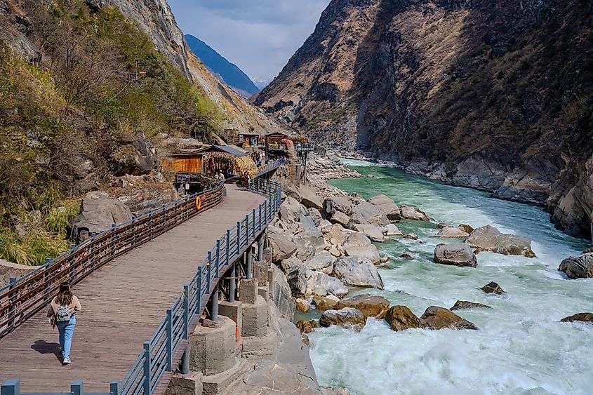
Tiger Leaping Gorge, located 60 kilometers north of Lijiang City, Yunnan, China, is a scenic canyon on the Jinsha River and part of the Three Parallel Rivers of Yunnan Protected Areas World Heritage Site. Named from a legend about a tiger escaping hunters by leaping across the river, the gorge is approximately 3,790 meters deep, making it one of the world's deepest and most spectacular canyons.
The gorge spans 15 kilometers between Jade Dragon Snow Mountain and Haba Snow Mountain, featuring rapids and steep cliffs. The area, home to the indigenous Nakhi people, has become a popular site for hiking tourism. Initially opened to foreign tourists in 1993, the gorge has attracted adventurers since the 1980s, despite its dangerous rapids that claimed lives in early rafting attempts. Local reactions to tourism development vary, and the region is also known for natural crystal mining.
3. Indus River Gorge, Pakistan - 5,200 m (17,100 ft)
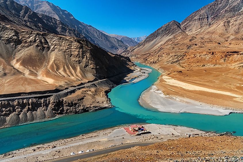
The Indus River carves a notable gorge as it bends around the Nanga Parbat massif (the western extension of the Greater Himalayas) before flowing onto the Punjab plains in Pakistan. Near Nanga Parbat, the gorge reaches depths of approximately 4,500 - 5,200 meters (14,800 - 17,100 feet). Researchers believe that the immense erosion resulting from the river’s capture and rerouting has exposed layers of middle and lower crustal rocks in this region. The Gilgit River, also found in this area, is the Indus River’s westernmost tributary.
The Indus River, stretching 3,180 km, originates from the springs northeast of Mount Kailash in Western Tibet, flowing through the contested Kashmir region, and eventually empties into the Arabian Sea near Karachi. It traverses regions rich in diverse ecosystems supported by tributaries from the Himalayan, Karakoram, and Hindu Kush ranges. Geologically, the Indus is part of the Indus-Yarlung suture zone, marking the collision of the Indian and Eurasian plates around 50 million years ago.
2. Kali Gandaki Gorge, Nepal - 5,571 m (18,278 ft)

Also referred to as Andha Galchi, the Kali Gandaki Gorge is the world’s second deepest gorge formed by the Kali Gandaki River (a tributary of the Ganges River) in the Nepal Himalayas. The Kali Gandaki River originates from the Nhubine Himal Glacier, close to the Tibetan border at Nepal’s Mustang region, at an elevation of 20,564 ft. The river then flows in the southern direction through a steep-sided deep canyon before it widens at Chele steel footbridge. Continuing its southward journey, the Kali Gandaki River then cuts through the steep Kali Gandaki Gorge, which separates the 29,795 ft high Dhaulagiri in the west from the 26,545 ft high Annapurna I in the east.
It is to be noted that if the canyon’s depth is measured by the difference between the river’s height and the height of the highest peaks on either side, then the Kali Gandaki Gorge is considered the world’s deepest gorge. In the past, the Kali Gandaki Gorge served as a trade route between India and Tibet for centuries. The gorge is placed within the Annapurna Conservation Area and, at present, forms a portion of the well-known trekking route that starts from Pokhara and ends at the sacred temple of Muktinath.
The Yarlung Tsangpo Grand Canyon features a unique ecosystem with many rare floral and faunal species still unaffected by human influence. The takin, a rare ungulate species found in the eastern Himalayas, is hunted here by the members of the local tribe. The region’s climate ranges from subtropical to Arctic type, with the highest temperature being 110.5°F recorded close to the Indian border at an elevation of 2,000 ft. However, at present times, the Yarlung Tsangpo Grand Canyon faces a severe threat, as the Chinese government has planned to construct a major dam on the portion of the Yarlung Tsangpo River. This dam would flow through the canyon for hydroelectric power generation as well as to divert water to other areas of the country.
1. Yarlung Tsangpo Grand Canyon, Tibet Autonomous Region, China - 6,009 m (19,714 ft)

Also known as the Brahmaputra Canyon or the Tsangpo Gorge, the Yarlung Tsangpo Grand Canyon is the world’s deepest canyon, reaching a maximum depth of 19,714 ft. With a length of 313.5 miles, it is also one of the largest canyons in the world. The Yarlung Tsangpo River, which originates close to Mount Kailash, flows eastwards for 1,100 miles and drains into the northern segment of the Himalayas before entering the gorge close to the village of Pei in Tibet. The canyon then extends for a distance of about 150 miles and bends around the 25,531 ft tall Mount Namcha Barwa, and then cuts through the eastern Himalayan range. As the canyon passes through the mighty peaks of Namcha Barwa and Gyala Peri mountains, it reaches an average depth of 16,000 ft around Mount Namach Barwa.
The overall average depth of the canyon is about 7,440 ft, whereas its maximum depth is 19,714 ft, making it the world’s deepest canyon. The waters of the river then drop from 9,500 ft close to Pei to about 4,900 ft at the Upper Gorge’s end, where it meets the Po Tsangpo River. The river continues to flow through the canyon’s lower segment and crosses the Indian boundary at an elevation of 2,170 ft. From here, the river flows through the Indian State of Arunachal Pradesh and finally becomes the Brahmaputra River.
The Takeaway
Canyons are truly one of Nature’s most impressive creations. Canyons offer some of the Earth’s most dramatic landscapes, and one must enjoy the breathtaking beauty of these canyons by visiting them and taking part in several recreational activities like hiking, rock climbing, trail running, whitewater rafting, etc, for experiences of a lifetime. If you are an admirer of natural creations, an extreme sports lover, or a photographer, the spectacular beauty of the canyons will never fail to amaze you.
The 10 Deepest Canyons In The World
| Rank | Name | Country | Max Depth |
|---|---|---|---|
| 1 | Yarlung Tsangpo Grand Canyon | China (Tibet) | 6,009 m / 19,714 ft |
| 2 | Kali Gandaki Gorge | Nepal | 5,571 m / 18,278 ft |
| 3 | Indus River Gorge | Pakistan | 5,200 m / 17,100 ft |
| 4 | Tiger Leaping Gorge | China | 3,790 m / 12,430 ft |
| 5 | Cotahuasi Canyon | Peru | 3,354 m / 11,004 ft |
| 6 | Colca Canyon | Peru | 3,350 m / 11,000 ft |
| 7 | Hells Canyon | United States | 2,400 m / 7,900 ft |
| 8 | Grand Canyon | United States | 1,857 m / 6,093 ft |
| 9 | Copper Canyon | Mexico | 1,600 m / 5,250 ft |
| 10 | Tara River Canyon | Montenegro | 1,300 m / 4,260 ft |
