Tibet
Tibet, nicknamed “the roof of the world,” is an autonomous region of China occupying the vast Tibetan Plateau. The region is China’s second-largest provincial-level entity after Xinjian, covering over 1.2 million square kilometers (almost half of the Tibet plateau). Tibet is the Earth’s highest region and shares Mount Everest (the world’s highest mountain) with Nepal.

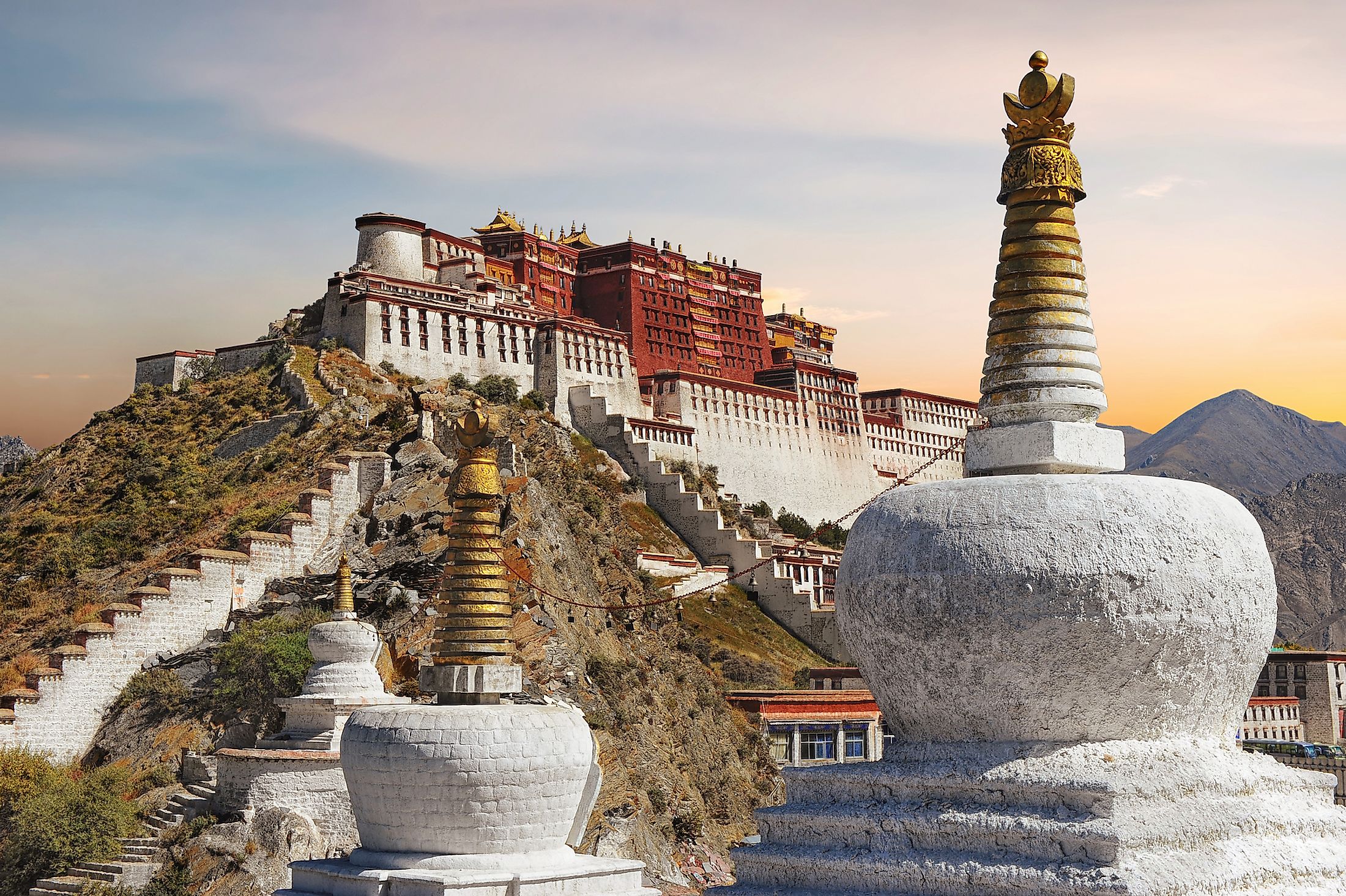
The area is administered as Tibet Autonomous Region within the People’s Republic of China and is home to the Tibetan people, Sherpa, Qiang, Tamang, Lhoba, and Monpa people. Tibet’s capital, Lhasa, hosts the hilltop Potala Palace used by Dalai Lama as his winter home.
Location

Tibet is a region in the Tibetan Plateau, a vast plateau covering approximately 2.5 million square kilometers, and occupies the Himalayas' northern portion. It is part of China’s Western Section and shares international boundaries with several countries, including India, Nepal, Bhutan, and Myanmar. These countries border the autonomous region to the south. The region borders several Chinese provinces, including Sichuan on the west, Qinghai on the southwest, and Yunnan on the northwest. The disputed Kashmir region borders Tibet to the west and Xingjiang to the north.
Geography

Tibet, an autonomous region of the People’s Republic of China, is the country’s second-largest provincial-level entity, after Xingjiang, spanning about 1.228 million square kilometers. Although the region is mainly considered part of East Asia, other European sources place it in Central Asia. Tibet occupies the southern part of the Tibetan Plateau and the northern Himalayas, known for its towering peaks. The region is known as the “roof of the world” because it is home to some of the world’s highest peaks, including Mount Everest, the world’s highest mountain located on the Tibet-Nepal border. Other prominent peaks in the region include Lhotse (Earth’s 4th highest mountain), Makalu (5th highest mountain), and Cho Oyu (6th highest mountain).

The Tibetan Plateau is the principal source of rivers in South, Southeast, and East Asia, including Mekong, Indus, Yellow, Yangtze, and Ganges Rivers. The Indus River, also called Sengge Zangbo in Tibet, has its heads waters in Mount Kailas in western Tibet. The two sources of the Mekong River (Zha and Ang) Confluence near the Tibet border and flows through the region and into Yunnan. As one of the richest water sources in the continent, Tibet is often referred to as the “Water Tower of Asia.” Besides rivers, the region has several lakes, including Siling, Nam, Dangre Yong, Yamzho Yun, Mapam, Puma Yung, and La’nga, among other lakes.
Climate

Although the locals refer to Tibet as “Kha-ba-can” or “Gangs-Ijongs,” meaning “the land of snows,” the region is generally dry for most months of the year. It receives an average of 460 mm of annual snowfall, of which much is received during the summer season. Tibet receives little precipitation because of the rain shadow effect, with the Himalayas blocking the monsoon winds originating from the south.
Temperatures are generally low and vary with elevation, with higher elevation being much colder than the lower valleys. Northern Tibet experiences higher temperatures during the summer months and extremely low temperatures and intense cold in the winter months. Lhasa (Tibet’s capital), located at 3,650 meters above sea level, experience a daily high of 30 degrees Celsius and a low of -19 degrees Celsius. The gale winds blowing across the region make the early mornings and nights bitterly cold.
Flora And Fauna

The dry climate of the Tibet Region does not support large forms of vegetation like trees, with the grassland covering almost two-thirds of the total area. The region has over 6,400 plant species, of which most are found in the lower parts in the southeast and south and river valleys. Common plants include poplars, willows, conifers, oaks, teaks, birches, rhododendrons, bamboo, elms, thorn trees, babul trees, tea bushes, om-bu (red-flowered trees growing near water), and gro-ba (white trees growing on hills). At least 1,000 plant species growing in Tibet have economic value. Domestic and wildflowers growing in Tibet include lotuses, blue poppies, oleanders, pansies, and orchids.

Tibet hosts over 100 mammal species, 50 amphibians, and 40 reptiles. Mammals inhabiting the forests include wild boars, tigers, stone martens, leopards, langurs, wild goats, buffalos, jackals, and lynx. Animals commonly found in dry bushes and high grassland areas are bighorn sheep, musk dear, mountain antelopes, brown bears, wild asses, lizards, scorpions, and snakes. Some 400 bird species can be spotted in the Tibet region, including black-necked cranes, jungle fowls, Himalayan monal pheasant, spotted tinamous, hawks, gulls, cinnamon teal, and Mynahs.
Demographics
The majority of the population of Tibet are the Tibetan people, with ethnic minority groups comprising Han Chinese, Lhoba, Monpa, Hui people, Tamang, and Sherpa. As of 2011, the autonomous region had a population of about three million people. Currently, Tibet is home to about 3.6 million people, with the Tibetans accounting for 90.5% of the population. According to historical data, the region’s population reduced significantly from over one million people in the 1910s to less than 400,000 people in the 1930s. However, the population increased steadily in the last five decades, but at a slower rate. The Tibetan Government in Exile has accused the PRC of encouraging migrants to the region to alter its demographic composition. They point to Qingzang Railway’s completion as encouraging migration to the region.
Religion
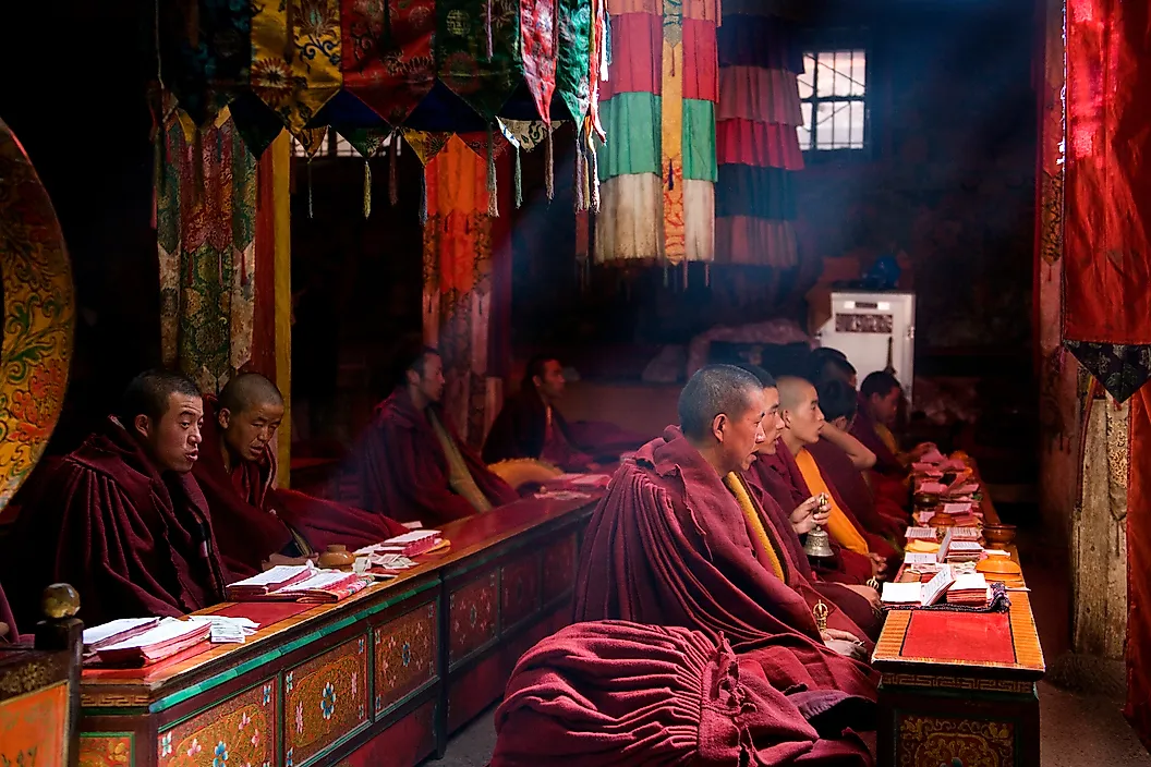
Religion influences almost all aspects of Tibetan's lives. The major religion practiced in Tibet is Buddhism, specifically Tibetan Buddhism, eclipsing the indigenous Bon religion. Tibetan Buddhism is a form of Vajrayana and Mahayana introduced to the region from northern India’s Sanskrit Buddhist practices. The religion follows four schools of thought; Gelug (way of virtue), Kagyu (oral lineage), Nyingma (the ancient ones), and Sakya (Gray Earth). Tibetan Buddhists account for 78.5% of Tibet’s population.

Bon, an ancient religion revolving around nature, is the second most popular religion, with 12.5% of the population or about 400,000 people adhering to it. The closely related Chinese religion is practiced by about 8.6% of the total population, mainly the Han Chinese. Islam, a major religion in Asia, is practiced by 4,000-5,000 Muslims who congregate in the four mosques across the autonomous region. About 0.02% of the region’s population practice Christianity. The Christians, mainly Catholics, live in Yanjing.
Economy

Tibet is rich in mineral resources, including large borax deposits, gold, iron, radium, arsenic, lead, and titanium. However, the region is still underdeveloped and has the lowest Human Development Index of China’s 31 provincial-level entities. Subsistence agriculture is the dominant economic activity, although arable land is limited. Rearing livestock like cattle, sheep, goats, and camel is a common practice in the area. Commonly grown crops include buckwheat, wheat, barley, vegetables, fruits, and rye.

In recent years, the authorities have promoted tourism in the area, with Tibetan Buddhism and surrounding mountains as the main focus areas. Popular tourist destinations include Potala Palace, Buddhist temples and monasteries, and the Himalayas. The handcraft centers make and sell several items to tourists visiting the area, including metal images, scroll paintings, religious images, jewelry, fabrics, carpets, and rugs. In rural areas, 40% of the cash income comes from the sale of fungus Ophiocordyceps sinensis, contributing US$225 million to Tibet’s GDP. Important industries in the Tibet region include agricultural processing, chemical, textile, machinery, and other light industries.
History

Tibetan region was first inhabited over 21,000 years ago. The Zhang Zhung culture moved to western Tibet from the Amdo region and became the first to practice the Bon religion there. The Tibetan Empire, founded by Yarlung kings in 618, reached its peak in the 8th century and fragmented by the mid-9th century. Songstsen Gampo, the empire’s founder, unified the region and established Buddhism. Other Tibetan kings made Buddhism the state religion and extended their reign as far as Central Asia and other Chinese territories. By the 790s, the Tibetan Empire extended to modern-day India, Burma, Nepal, Afghanistan, Pakistan, Bangladesh, Tajikistan, Kyrgyzstan, and Kazakhstan. China and Tibet signed a treaty in 821/822 CE, defining the boundary between them.

Tibet was conquered by the Mongol Empire in 1244, although it became an autonomous region within the empire. When Kublai Khan founded the Yuan Dynasty in 1271, he incorporated Tibet as part of his dynasty and made Drogon Phagpa the regional head. Between 1354 and 1642, several dynasties ruled Central Tibet, including areas like Lhasa, Shigatse, and Nedong. Ganden Phrodrang ruled Tibet from 1642 to 1717 and was succeeded by Dzungar Khanate. However, the Machu people expelled the Dzungar forces in the Dzungar-Qing War, and the region came under Qing Dynasty in 1724, marking the beginning of the dynasty’s rule over Tibet. Qing Dynasty was toppled in 1912, and Tibet became a de facto independent state until 1950, with the Dalai Lama and the regents as the leaders of the State of Tibet.
Administration

The region came under the PRC’s control in 1951 following the signing of the 17-point agreement between Tibet leaders and the Chinese central government. The agreement, ratified in Lhasa, provided for Tibet’s autonomy, with Dalai Lama as the leader. In 1955, Dalai Lama’s administration was excluded from a committee managing Tibet’s autonomy. Tibet became an autonomous region within the PRC in 1965, making it China’s provincial-level entity. The region is divided into three traditional provinces, namely Kham, U-Tsang, and Changthang. However, the autonomous region is divided into one prefecture (Ngari Prefecture) and six prefecture-level cities.