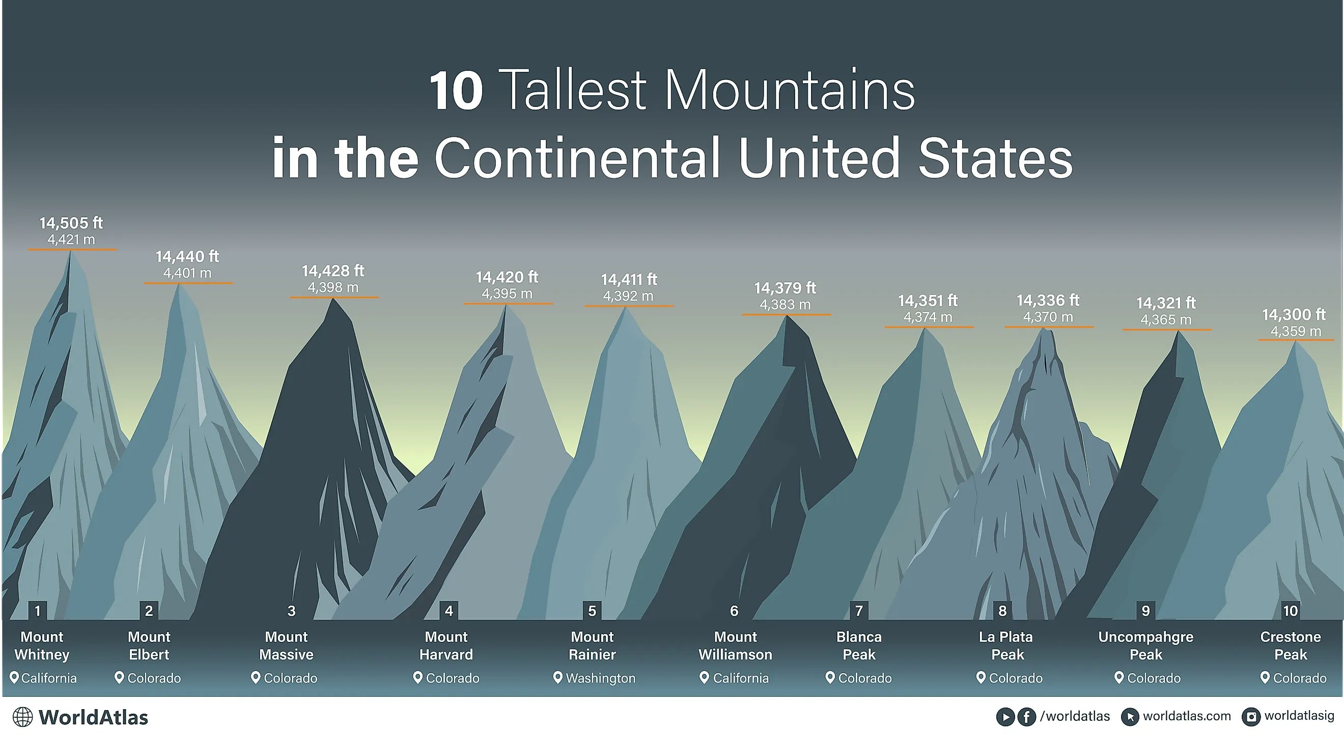
10 Tallest Mountains In The Contiguous United States
Alaska is home to the tallest mountains in the country, including Denali (Mount McKinley), which is in the top spot at over 20,310 feet. This is unfortunate for most of the nature-loving population, many of whom will never visit this far northern state.
Thankfully, the lower 48 also hosts a variety of impressive peaks. We will cover 10 of these much more accessible mountains in order of elevation, from how they got their names to significant geological and historical facts.
10. Crestone Peak, Colorado - 14,300 Feet

Crestone Peak is the 10th-highest mountain in the contiguous United States, rising to about 14,300 feet in southern Colorado's Sangre de Cristo Range.
Located within the Rio Grande National Forest, Crestone Peak is one of the state's more rugged Fourteeners (a peak above 14,000 feet), but it is still a popular spot for hiking and climbing. Remote and less trafficked than peaks closer to Denver, it demands preparation and stamina but rewards with incredible views that don't see the same level of crowding as other entries on this list.
Getting to the summit is a bit of a technical climb. The standard South Face route is rated as Class 3 and requires careful scrambling and route-finding abilities. Furthermore, the nearby Crestone Needle adds to the area's appeal to mountaineers, drawing experienced climbers seeking an even more challenging alpine ascent.
9. Uncompahgre Peak, Colorado - 14,321 Feet

Uncompahgre Peak is the highest point in the San Juan Mountains and the ninth-tallest summit in the Lower 48, reaching 14,321 feet. Unlike many of Colorado’s Fourteeners, its summit is broad and flat-topped, resulting from ancient volcanic activity rather than uplifted granite. Its unique shape makes it visually distinct and hard to miss, with sheer cliffs dropping off on several sides.
Located in the Uncompahgre Wilderness of western Colorado, the standard route for most trying to get to the top is an approach via the Nellie Creek Trailhead, a 7.4-mile, non-technical hike that anyone with decent endurance can do. Despite the climb's relative ease, the region's remoteness makes traffic relatively light.
From the summit, you will get unbeatable views of jagged San Juan ridgelines, various alpine basins, and deep, glacier-carved valleys all around.
8. La Plata Peak, Colorado - 14,336 Feet

La Plata Peak, at 14,336 feet, lies within the Collegiate Peaks of the Sawatch Range and is also part of the San Isabel National Forest in central Colorado. The name "La Plata" means "silver" in Spanish, a reference to the region’s longstanding mining history, dating back centuries.
This mountain dominates the skyline west of Twin Lakes and drains into both the Arkansas and Roaring Fork River systems. With its sizable height, on clear days, it’s even visible from as far east as the plains near Buena Vista.
La Plata's broad massif includes numerous steep ridgelines and glacial cirques that feed other alpine creeks below. The most commonly used route to ascend it, the Northwest Ridge, is a strenuous walk featuring long switchbacks and scree slopes.
7. Blanca Peak, Colorado - 14,351 Feet

Blanca Peak is the highest summit in the Sangre de Cristo Mountains, rising sharply from the San Luis Valley. It can be seen for miles across southern Colorado. It is a major part of the Sierra Blanca Massif, a compact group of Fourteeners including Ellingwood Point and Mount Lindsey.
Its upper slopes are composed of granitic rock, with numerous cirques and lakes carved by ancient glaciation below. The surrounding terrain also notably includes moraines and bristlecone pine groves, marking the transition between high desert and subalpine ecosystems in this seemingly untouched landscape.
Blanca is considered sacred by several Native American tribes, including the Navajo, who refer to it as Sisnaajini, the eastern boundary of their traditional homeland.
6. Mount Williamson, California - 14,379 Feet

Mount Williamson is, in fact, the second-highest peak in California and the sixth-tallest in the contiguous United States, towering at 14,379 feet above the southern Sierra Nevada.
Directly east of Fresno, it presents one of the most dramatic vertical reliefs in the state, looming more than 9,000 feet above the Owens Valley below. The mountain’s bulk is notably massive and angular, and marked with extensive granite slabs and steep couloirs shaped by none other than glacial erosion.
This peak is part of the Inyo National Forest and lies within the John Muir Wilderness. While less visible from major roads than Mount Whitney, its distinctly sheer rise from the arid valley floor to alpine heights is among the most impressive in North America.
5. Mount Rainier, Washington - 14,411 Feet

Mount Rainier marks the tallest point in the Cascade Range, a chain of volcanoes spanning the Pacific Northwest. Rainier, a massive stratovolcano with an enormous 30 square-mile base, dominates western Washington's landscape.
Mount Rainier is heavily glaciated, holding more glacial ice than any other peak in the lower 48. Over two dozen major glaciers descend from its summit, feeding rivers that stretch toward Puget Sound and the Columbia Basin. In terms of volcanic action, the mountain is still considered active, with steam vents and periodic seismic activity.
The peak influences its own weather, too. It is often cloaked in clouds even when the surrounding areas are clear. On rare cloudless days, it’s visible from Seattle, Tacoma, and much of western Washington.
It was named by British explorer George Vancouver in 1792 and is a prominent feature of Mount Rainier National Park, established in 1899. The native Puyallup name for the peak, however, is "Tahoma" or "Tacoma," appropriately meaning "the mother of waters."
4. Mount Harvard, Colorado - 14,420 Feet

Mount Harvard reaches 14,420 feet, making it the third-tallest mountain in Colorado. It anchors the northern portion of the Sawatch Range and is part of the Collegiate Peaks Wilderness, another region known for its high concentration of Fourteeners. The mountain was named in 1869 by members of the first Harvard Mining School expedition, who also named nearby Mount Yale.
The upper slopes are composed of granitic rock, with wide tundra benches and steep headwalls shaped by Pleistocene ice. Like many other peaks mentioned here, glacial valleys and alpine basins that provide for major waterways surround its base, the Arkansas River in this case.
3. Mount Massive, Colorado - 14,428 Feet

Mount Massive fittingly ranks third with a name like that, ascending 14,428 feet in the Sawatch Range. Once considered higher than nearby Mount Elbert, residents even piled stones on its summit to help it claim the title. While slightly shorter in reality, it still dominates the skyline with a wide, imposing presence unmatched in horizontal scale.
It has earned its name from its sprawling bulk. It comprises five summits above 14,000 feet, each connected by a long, high ridge. Its summit area covers more square miles above 14,000 feet than any other peak in the contiguous United States.
Situated within the Mount Massive Wilderness, the mountain rises west of Leadville and is a hotspot for outdoor recreation, including hiking, climbing, and mountain biking.
2. Mount Elbert, Colorado - 14,440 Feet

Mount Elbert is the highest point in Colorado and the entire Rocky Mountain range, with an elevation of 14,440 feet. It is yet another landmark in the impressive Sawatch Range.
Named after Samuel Hitt Elbert, a 19th-century territorial governor, the mountain has long held symbolic importance in the state.
Despite its height, Elbert’s profile is broad and gradual rather than steep or jagged, allowing you to ascend it without a technical climb, but rather a relatively doable 10-mile hike via the North Elbert Trail. Other routes include the Northeast Ridge trail, which is just over 12 miles long, or an even more strenuous southern trail, spanning over 15 miles.
1. Mount Whitney, California - 14,505 Feet

Mount Whitney is officially the tallest mountain in the contiguous United States, reaching a lofty elevation of 14,505 feet. It rises from the eastern edge of California’s Sierra Nevada, just west of Lone Pine. It was named in 1864 after Josiah Whitney, then California’s state geologist.
Whitney is part of the Inyo National Forest and borders Sequoia National Park near the Great Basin's western edge. This famed mountain is composed of granite formed during the Cretaceous period and shaped by extensive glaciation, creating cliff walls and drops along the way up. Its eastern face is undoubtedly one of the most impressive (both physically and visually) vertical rises in the country, climbing over 10,000 feet from the valley floor to the summit, all in less than 15 miles.
From the top, views span the Mojave Desert, Kings Canyon, and the high Sierra crest. Another interesting aspect of Mount Whitney is its proximity to Death Valley, one of the lowest points in North America, at 282 feet below sea level.
How Many of These Record-Setting Peaks Will You Visit?
So there you have it, the 10 highest peaks that you can find within mainland America. Far less remote than Alaska, you have less of a reason not to get out and try to visit one or two (or more) this year. Many of which feature extensive trail networks and national park infrastructure, these mountains not only stand as important natural landmarks and vital parts of the greater ecosystem, but also incredible recreational areas for those who want a unique view high above the country.