The Last Time Glen Canyon Dam Opened Its Spillway
August 12, 1984. Engineers ran 50,000 cubic feet per second through the repaired left spillway, shut it off, drained the tunnel and walked in to check the concrete. They found nothing wrong, and in more than forty years since, Glen Canyon Dam has not needed to open a spillway again. The reason that test mattered so much is what had happened fourteen months earlier, when the same tunnels came close to destroying the dam and sheets of plywood were briefly the thing standing between Lake Powell and the Colorado River. The other reason nobody has opened them since is not that the engineering improved. It is that the water never came back.
Here is what happened in 1983, why the fix worked, and why the spillways have sat dry through an era when the fear runs entirely the other way.
What A Spillway Is For

Glen Canyon Dam has three ways to pass water. Turbines send it through the powerplant and generate electricity. River outlet works, sometimes called the bypass or jet tubes, dump it downstream without generating anything. And the spillways are the last resort.
The spillways are two 41-foot-diameter tunnels bored through the sandstone abutments on either side of the dam, controlled by radial gates. They exist for one job: to get rid of water that would otherwise go over the top of a concrete arch dam. They were designed for short-term emergency use, not for weeks of continuous operation.
That distinction is the whole story of 1983.
The Spring That Broke The Assumptions

Runoff in the upper Colorado basin climbed steadily through late May 1983, and it did not stop.
On June 27 the inflow to Lake Powell reached 111,500 cubic feet per second. The reservoir kept rising, the turbines and outlet works were already at capacity, and the only remaining option was the tunnels nobody wanted to use.
Downstream at Lees Ferry the Colorado peaked at 97,300 cubic feet per second, which remains the highest flow ever recorded there since the dam was built.
June 6, 1983

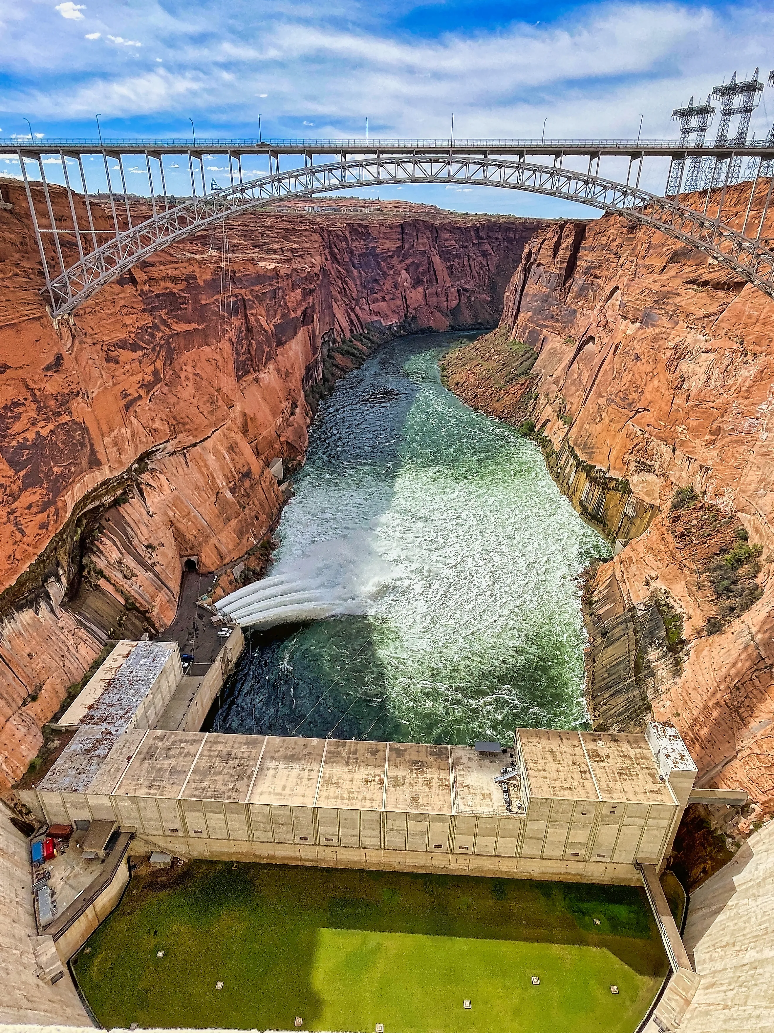
Glen Canyon Dam releasing floodwater in 1984, testing repairs of the spillways which were heavily damaged in 1983.
Early that morning operators heard loud rumbling from the left spillway and saw material being ejected from the outlet. Not water. Material.
They closed the left gates, opened the right, and sent engineers into the tunnel. What they found was cavitation damage: chunks of concrete missing at the elbow, where the steeply sloped spillway tunnel meets the horizontal diversion tunnel it was built from.
The problem was that the reservoir was still filling. They could not simply stop using the spillways, and the damaged left tunnel had to keep metering out flow regardless.
What Cavitation Actually Does
Worth explaining, because it is the villain of this story and it is not erosion in any ordinary sense.
Water moving fast enough over an irregular surface drops in local pressure until it flashes into vapor. Those vapor bubbles are then carried into higher-pressure water and collapse, and each collapse delivers a tiny, extremely violent shock against whatever surface is nearest.
Do that billions of times a second against three-foot reinforced concrete and the concrete loses. Then the water reaches the sandstone underneath and the sandstone loses much faster.
The Hole They Found In August

Once the flood passed, crews dewatered the tunnels and went in properly. The numbers are hard to picture.
Below the vertical bend, the water had excavated a cavity in the sandstone roughly 35 feet deep, 134 feet long and 50 feet wide. Other accounts of the left spillway concrete describe a hole 32 feet deep, 30 feet wide and 150 feet long chewed through three feet of reinforced concrete.
Thousands of tons of concrete, rebar and rock had been carried out of the tunnels and deposited in the river.
The Plywood
This is the detail that carries the story, and it is true.
To avoid running the damaged spillways any harder, Reclamation needed to hold more water behind the gates than the gates were built for. On the evening of June 6, crews bolted four-foot plywood flashboards to the tops of the radial gates. In early July, eight-foot steel extensions replaced them.
Those extensions bought somewhere between 1.2 and 1.4 million acre-feet of emergency storage. For a stretch of days in June 1983, sheets of plywood were part of the structure holding back Lake Powell.
How Close It Came
The popular version says the dam nearly failed, and it deserves a careful answer rather than a dramatic one.
The genuine fear was that continued cavitation would erode through the plugs in the old diversion tunnels at the base of the dam. Had that happened, Lake Powell would have begun draining from underneath the structure, which would have taken the dam with it.
Against that, Reclamation's own modern dam-safety guidance notes that cavitation inside a confined tunnel is less likely to progress to outright dam failure than cavitation in an open spillway, because the flow stays directed. And no source has ever put a failure probability on 1983.
The crisis was real. The margin has never been quantified, and anyone who tells you the dam was minutes from collapse is filling in a number nobody has.
Lake Powell's All-Time High

The spillway gates closed on July 7, 1983. The reservoir kept rising for another week.
On July 14 Lake Powell reached 3,708.34 feet, roughly eight feet above the 3,700-foot full pool line. That is the highest the reservoir has ever been, and it has not come close since.
The Fix Was A Redesign, Not A Repair
Engineers had already identified the need for aeration slots before 1983, borrowing from experience at Yellowtail Dam, but the design was not finished when the flood arrived.
The solution was elegant. Crews cut air slots roughly four feet wide and four feet deep into each inclined tunnel, upstream of the bend where the damage began. A small ramp lifts the sheet of water just enough to draw air underneath it. That air-and-water mixture is compressible, so when the vapor bubbles collapse they collapse into air rather than against concrete.
The work cost around $30 million and was finished before the next runoff season.
The 1984 Test
1984 brought another above-average runoff year, and the repaired spillways handled it without any sign of cavitation.
Then on August 12, 1984, the left spillway was deliberately run at 50,000 cubic feet per second, shut down, dewatered and inspected. No damage.
That is the last recorded spillway operation at Glen Canyon Dam. Everything since has been a matter of not needing them.
Every Big Release Since Has Used A Different Route
This is the technical point that trips up a lot of coverage.
Since the mid-1990s, Reclamation has run periodic High Flow Experiments through Glen Canyon, deliberately releasing large volumes to rebuild sandbars and beaches downstream in the Grand Canyon. Those releases go through the river outlet works, the bypass tubes at the base of the dam.
They are not spillway events. A photograph of water jetting from the base of Glen Canyon Dam is almost always the bypass tubes, and it gets captioned as a spillway release constantly.
The Problem Reversed Completely

Here is why forty-two years have passed without a spillway opening, and it is not because the dam got better at handling floods.
On April 13, 2023, Lake Powell hit a modern low of 3,519.92 feet. That is about 188 vertical feet below the 1983 crest. The concern at Glen Canyon is no longer whether the spillways can pass a flood. It is whether the reservoir will stay high enough to keep water above the power intakes and the turbines turning.
The same structure that in 1983 was being held together with steel flashboards against too much water now sits in a basin negotiating over how to ration too little.
The Spillways Are Still There

Two 41-foot tunnels through the sandstone of Arizona, aerated, tested, and unused since the Reagan administration.
It was suggested after 1983 that permanent stronger flashboards be kept on the gates as insurance against a repeat, which is a reasonable precaution for a structure whose worst day involved improvising with plywood. The aeration slots mean the tunnels should now survive extended use rather than eating themselves.
Whether they ever get used again depends on something no engineer controls. It would take a Rockies snowpack big enough to fill a reservoir that has spent two decades emptying, and if that ever happens, the spillways at Glen Canyon will be the least of anyone's concerns.