9 Great Road Trips to Take in New England
Vermont has a name for the roads that climb over its mountain spines. They are called gap roads, and the state lists seven of them as seasonal drives that reopen each spring. Across New England, notches, river valleys, and a coastline broken into passages and peninsulas dictate the shape of the region's most scenic drives. The nine routes listed below include a historic fort in New Hampshire, landmark bridges in Rhode Island, and even a ferry in Connecticut that's been running since 1769. Explore New England from the driver's seat with these road trip itineraries.
CT 148 Across the Connecticut River

Route 148 leaves Chester, Connecticut, heading east and ends at the riverbank. The state highway continues across the Connecticut River as a ferry, and has done since 1769. Chester Center sits 3.5 miles from the west landing. Driving around instead, north through East Haddam on Route 82, runs 11.4 miles. Jonathan Warner opened the crossing on land he owned on both banks, and Warner's Ferry carried supplies over the river during the Revolutionary War. The towns of Chester and Lyme took it over in 1877, the name changed in 1882, and the highway department assumed control in 1917.
The current boat, the Selden III, holds eight or nine cars. Nothing here runs to a timetable. The ferry operates on demand, with no scheduled departures, and service comes as vehicles and passengers arrive. Vehicles queue at the landing and board as the boat returns. The season runs April 1 to November 30, weekdays 7 am to 6:45 pm and weekends 10:30 am to 5 pm, with Thanksgiving off. A car costs $5 on weekdays and $6 on weekends.
RI 138 Over Narragansett Bay

Narragansett Bay splits southern Rhode Island into two passages with an island between them, and Route 138 answers with bridges. Drivers heading east leave the mainland at North Kingstown and cross the West Passage on the Jamestown Verrazzano Bridge. Route 138 then runs the length of Conanicut Island before crossing the East Passage into Newport. The Rhode Island Turnpike and Bridge Authority owns and maintains both spans and the run of Route 138 between them, so a single agency runs the whole crossing. The Claiborne Pell Bridge carries the second crossing.
The $57 million bridge opened to traffic on June 28, 1969, at a ceremony held at the toll plaza that still houses the authority's headquarters. Its towers rise 400 feet above the water. The legislature renamed it for Senator Claiborne Pell in 1992. The tolled run from Saunderstown to Newport measures 10.2 miles and takes about 17 minutes. The authority operates four bridges in Rhode Island, and this one route uses two of them.
MA 32A Into Quabbin Park

The Swift River Valley in central Massachusetts was deliberately destroyed. Four towns were flooded when the valley was inundated: Enfield, Prescott, Dana, and Greenwich. The reservoir that replaced them was built in 1939 and now stores 412 billion gallons across 39 square miles, with 181 miles of shoreline. Winsor Dam carries 2,640 feet across the southern end. The forest that grew back over the empty townsites has a name in the state's own documents, which call the place an accidental wilderness. Only one part of it is open to a car.
Driving for sightseeing is permitted inside Quabbin Park, roughly 3,000 acres at the southern tip that stay generally open to the public. It is prohibited in every other part of the watershed. The Quabbin Reservation beyond it covers roughly 45,000 acres bounded by and within Routes 9, 202, 122, and 32A. Dogs are barred from every management area. From Petersham, the run south on Route 32A and west on Route 9 covers 25.2 miles in roughly 40 minutes.
NH 1A and 1B Along the Seacoast

New Hampshire owns less ocean frontage than any other coastal state. Federal measurements put its general coastline at 13 miles, against 28 for Delaware and 40 for Rhode Island. The state's Coastal Byway follows that frontage on Routes 1A and 1B, entirely within Rockingham County. The highway department designates it, and it links 10 units of the state park system between Seabrook and Portsmouth. Harbor defense is the thread that ties the drive together. Odiorne Point State Park in Rye keeps the evidence of that history, and trails run through it to the rocky shore. The Seacoast Science Center shares the site, open seven days a week in summer from 10 am to 4 pm.
Fort Stark occupies the far end, on Jerry's Point at the southeast corner of New Castle Island. Its museum displays artifacts of the 22nd Coast Artillery, headquartered there during the Second World War. A marked walking trail circles the grounds, with a small beach and kayak access to Little Harbor. There are no restrooms, and parking is limited. End to end, the shore road is 17.9 miles and 40 minutes of driving, slower than the interstate over the same ground. Fort Stark keeps a short season, May 22 to October 12 in 2026, with the gate open 10 am to 6 pm.
VT 17 Over the Appalachian Gap

Hikers on the Long Trail cross Route 17 at the height of the Appalachian Gap, the plainest sign that the road has topped the Green Mountain spine. The Green Mountain Club has built and maintained that footpath since 1910, and it publishes driving directions over the gap from Bristol on the west and Waitsfield on the east. Walkers and drivers reach the same point from opposite directions.
The road leaves Bristol, climbs steadily, and tops out in Buels Gore, an unincorporated sliver of Chittenden County. Camel's Hump State Park surrounds the gap. East of the summit, the road descends to Waitsfield, 22.7 miles and roughly 35 minutes from Bristol. There, it meets Route 100 in the Mad River Valley.
VT 58 Through Hazen's Notch

The pavement runs out west of Lowell. That stretch of Route 58 is not a state road. The towns maintain it, the surface turns to dirt, and it narrows on the climb into Hazen's Notch. The notch takes its name from a road that was never finished. It was cut in 1779 by General Moses Hazen and his Revolutionary forces, who meant to reach and invade Montreal. The work stopped at the notch, which still marks the terminus of the Hazen Military Road. The notch is a steep-walled gap between Sugarloaf and Haystack Mountains.
Its south-facing cliffs are serpentine rock, and they hold the 273-acre Hazen's Notch Natural Area, set aside for the rare plants that grow on that stone. The Long Trail crosses on its way north. West of the height of land, the drive opens toward Jay Peak, with sugarhouses set back in the woods. Route 58 is the second of Vermont's gap roads on this list, after the Appalachian Gap. The leg from Montgomery Center to Lowell is 10.5 miles, roughly 20 minutes. The road is not paved throughout, and it is closed from December to April.
NH 26 Through Dixville Notch

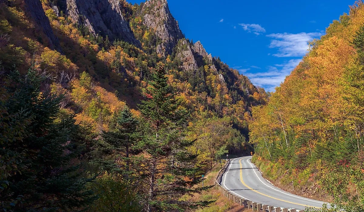
Rock walls close in on both sides northwest of Errol. Route 26 threads between them. Dixville Notch State Park protects 127 acres of that gap in Coös County. The pavement follows the notch floor before dropping toward Colebrook. Longer walks climb to the Dixville Table Rock, a fin of rock standing above the road. Waterfalls run on two separate mountain brooks inside the park.
Colebrook to Errol runs 21.6 miles, close to half an hour. The road continues east from the notch to the Maine line. The best stop asks almost nothing of a driver. The Baby Flume, also called the Dixville Flume, sits less than 0.1 mile from a roadside parking area. Flume Brook carved the gorge there, and the water drops 18 feet over three ledges.
ME 26 Through Grafton Notch

The Bear River sets the line in western Maine. Route 26 follows it for most of the run north out of Newry. The Grafton Notch Scenic Byway covers 21 miles of that road, from a point just above the Sunday River ski area to Upton and the New Hampshire line. Maine's transportation department suggests allowing three hours, which says something about how often drivers stop. Two of the stops are a short walk from the shoulder.
Screw Auger Falls drops into a gorge cut by the Bear River, and Mother Walker Falls drops below a natural bridge a little further north. Grafton Notch State Park contains them both, along with the trailheads for its own Table Rock and the Eyebrow. Newry to Upton is a 20.8-mile drive of roughly 25 minutes. The notch itself marks where the Mahoosuc Range ends, and the Mahoosucs are where the White Mountains end. Drivers who continue past Upton cross into New Hampshire, where the same route number picks up and runs on toward Errol and the Dixville Gap.
ME 17 to the Height of Land

The overlook is the reason to drive this road. The Height of Land on Route 17 opens onto the Mooselookmeguntic basin, Toothaker Island, the upper and lower Richardson lakes, and the White Mountain chain beyond them. Federal highway records describe the view in those terms. The Rangeley Lakes National Scenic Byway runs 35.6 miles over Routes 17 and 4, between Houghton in the south and Madrid by way of Rangeley in the north.
Federal records put the driving time at two to three hours and note that visitors who stop should allow eight or more. The southern approach up Route 17 out of Mexico passes Coos Canyon in Byron, where Maine's own Swift River runs over bare rock, before the road climbs. The approach from Mexico to Oquossoc adds 35.5 miles and about 45 minutes, and that is a separate figure from the byway's own length.
Nine Ways To Drive New England
The nine drives run through a place where the landscape calls the shots. Short mileage costs these drives nothing. A 21-mile byway through Grafton Notch does not need distance to justify the trip, and each one of these routes is as worthy of your time as the landmarks and towns along the way.