8 Most Scenic Drives in Arizona
A road trip through Arizona can begin among saguaro-covered desert slopes and climb into cool pine forests, while another can follow a canyon rim before opening onto enormous stretches of high desert. For Arizona residents planning a weekend drive or visitors looking for a road trip that goes beyond the usual interstates, the state's scenic highways offer plenty of ways to experience that variety from behind the wheel.
The eight drives below were chosen for the landscapes they reveal along the route, rather than simply for the attractions at either end. The Apache Trail winds past the jagged volcanic formations of the Superstition Mountains before narrowing toward the steep walls of Fish Creek Canyon. In Petrified Forest National Park, the main road crosses the multicolored hills of the Painted Desert and colorful badlands scattered with pieces of petrified wood. Some, like Desert View Drive, can be comfortably covered in an afternoon, while others deserve most of a day. Wherever you go, the scenery is best enjoyed at a slower pace, with time built in for designated overlooks and roadside stops.
Sedona-Oak Creek Canyon Scenic Road

Route: State Route 89A
Drive: Sedona to the Flagstaff area through Oak Creek Canyon
Scenic segment: Approximately 15 miles
Few Arizona roads change character as quickly as State Route 89A through Oak Creek Canyon. Leaving Sedona, drivers are surrounded by the towering red-rock formations that define the area. The road then follows Oak Creek into a narrower, greener canyon before climbing toward the ponderosa pine forests of the Colorado Plateau. The first portion of the drive is dominated by exposed sandstone cliffs, but the landscape gradually becomes more heavily wooded as the road enters Oak Creek Canyon. Oak Creek itself winds through the canyon below, and sycamores and other vegetation create pockets of greenery between the rock walls.
Slide Rock State Park sits beside the creek in the lower canyon, although travelers focused primarily on the drive can simply continue along SR 89A and enjoy the changing landscape from the road. Farther north, near the top of the switchbacks, Oak Creek Vista provides one of the most expansive roadside views back into the canyon and is an obvious place to pause. The climb toward Flagstaff is an important part of what makes this route distinctive, as the red-rock scenery gradually gives way to higher-elevation forest.
Spring and fall are particularly pleasant times for this drive. Summer weekends can bring heavier traffic, while winter can introduce snow and ice at higher elevations. Because conditions and restrictions can change, check the Arizona Department of Transportation's (ADOT) AZ511 system before heading out.
Sky Island Scenic Byway

Route: Catalina Highway
Drive: Tucson to the Mount Lemmon/Summerhaven area
Scenic segment: Approximately 27 miles
The Sky Island Scenic Byway offers one of Arizona's most striking elevation changes without requiring a cross-state road trip. Beginning in the Sonoran Desert outside Tucson, the Catalina Highway climbs the Santa Catalina Mountains toward Mount Lemmon, passing through several distinct ecological zones along the way. At the lower elevations, the scenery is unmistakably Sonoran, with giant saguaros and dry, rocky slopes surrounding the highway. As the road climbs, the cactus-filled landscape gradually gives way to grasslands, oak woodland, and eventually pine forest.
That transition is the real attraction. Rather than arriving at one particular viewpoint and calling the drive finished, travelers watch the landscape change almost continuously as the road gains nearly 6,000 feet of elevation. Roadside overlooks provide broad views across the desert basin below. Higher up, the scenery becomes cooler and more heavily forested, with rocky mountain slopes replacing the open desert. The road eventually reaches the Mount Lemmon and Summerhaven area, where the environment feels remarkably different from the desert landscape at the beginning of the drive.
The highway is paved but winding, with cyclists, wildlife, and changing weather conditions to watch for. Summer monsoon storms can arrive quickly, while snow and ice are possible at higher elevations in winter. The Forest Service and ADOT recommend checking conditions before traveling.
Coronado Trail National Scenic Byway

Route: US 191
Drive: Clifton to Eagar
Scenic segment: Approximately 120 miles
If the Sky Island Scenic Byway demonstrates how quickly Arizona can climb from desert to forest, the Coronado Trail shows just how expansive that transition can be. The roughly 120-mile stretch of US 191 between Clifton and Eagar crosses some of the state's most rugged mountain country. The drive begins near Clifton and Morenci in the high desert of eastern Arizona. The enormous copper-mining landscape around Morenci provides an unusual opening to the journey before US 191 begins climbing into the Apache-Sitgreaves National Forest.
As the elevation increases, the scenery changes from exposed, rocky slopes to dense forest. The road winds through the mountains with hundreds of curves, passing high-country scenery around Hannagan Meadow before reaching the communities of Alpine and Eagar. This is a drive where the road itself is central to the experience. Long straight stretches are uncommon, and the route repeatedly reveals new views around bends. At higher elevations, pine, fir, and aspen replace the vegetation of the lower country.
Because the route reaches elevations approaching 9,000 feet, conditions can vary considerably between its southern and northern ends. Late spring through fall generally offers easier mountain-driving conditions, while winter can bring snow and ice. Drivers should allow substantially more time than the mileage alone suggests and check AZ511 before departing.
Apache Trail Historic Road

Route: State Route 88
Drive: Apache Junction toward Roosevelt Lake
Scenic segment: Historic Apache Trail
The Apache Trail is one of Arizona's more unusual scenic drives because the landscape is only part of the experience. The road itself winds through rugged desert terrain, around the Superstition Mountains, and toward the lakes and canyons of the Salt River country. From the Apache Junction area, SR 88 passes Lost Dutchman State Park before leaving the developed edge of the Phoenix-area desert behind. The Superstition Mountains dominate the horizon, with jagged volcanic formations rising above the desert vegetation. Farther along, the road becomes increasingly narrow and rugged as it approaches Fish Creek Canyon and the lakes created by the Salt River system. The scenery shifts from open desert to steep canyon walls, rocky slopes, and water surrounded by an otherwise arid landscape.
The Apache Trail requires more planning than the paved scenic highways on this list. A section of SR 88 remains unpaved, and conditions can change after heavy rain or rockfall. ADOT's current 2026 information indicates that the unpaved section is open but remains narrow, steep, and winding. A suitable vehicle, extra time, and a check of current road conditions are important. During extreme summer heat, travelers should also carry ample water and avoid assuming that remote stretches of the route will have services nearby.
Kayenta-Monument Valley Scenic Road

Route: US 163
Drive: Kayenta to the Utah state line through Monument Valley
Scenic segment: Approximately 28 miles
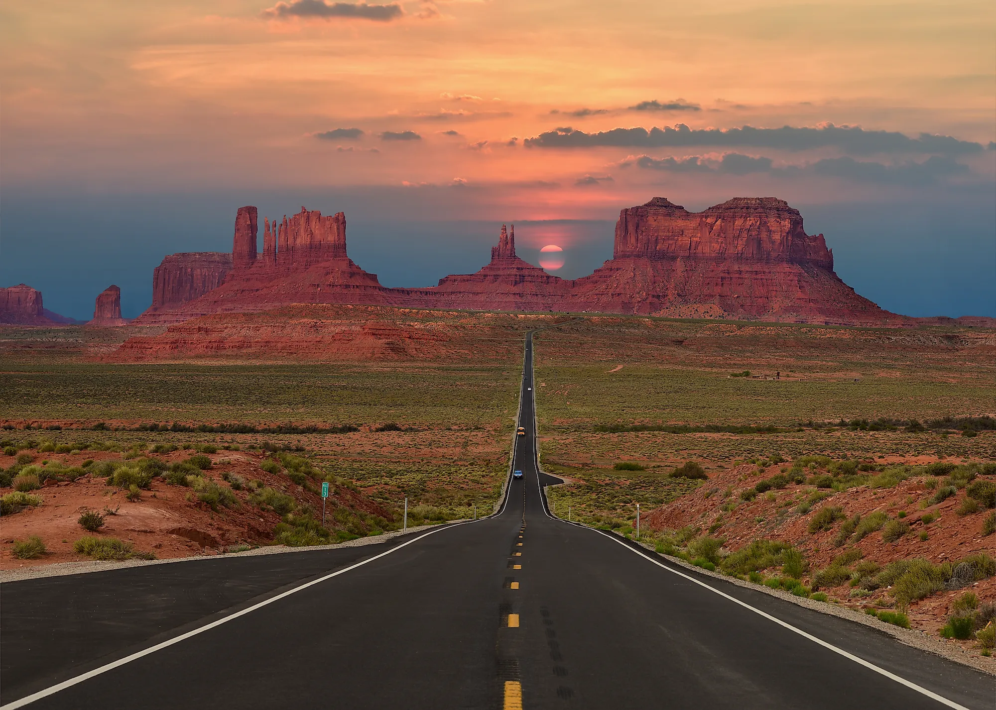
Some scenic drives impress through constant curves and elevation changes. US 163 through Monument Valley does almost the opposite. Its appeal comes from long, open views and enormous sandstone formations that seem to rise directly from the surrounding desert. Leaving Kayenta, the highway passes through broad, sparsely developed desert terrain. As it approaches Monument Valley, isolated mesas and buttes begin to dominate the horizon. The formations grow increasingly prominent until the road enters one of the most recognizable landscapes in the Southwest.
The road's relatively straight alignment gives drivers time to appreciate the scale of the landscape. Instead of squeezing through a narrow canyon, US 163 provides an expansive view across the desert, with towering sandstone formations standing against the sky. The route provides access to the Monument Valley Navajo Tribal Park area, but travelers who want to keep the experience centered on the drive can simply appreciate the changing views along US 163 and stop only at designated roadside areas.
Summer temperatures can be severe, particularly during the middle of the day. Spring and fall generally provide more comfortable conditions for roadside stops, while drivers should remember that this route crosses the Navajo Nation and should respect posted regulations and private or tribal lands.
Desert View Drive

Route: State Route 64
Drive: Grand Canyon Village to Desert View
Scenic segment: 23 miles
For an Arizona drive built almost entirely around changing views of one landscape, Desert View Drive is hard to match. The 23-mile section of SR 64 follows the South Rim of the Grand Canyon National Park from Grand Canyon Village east to Desert View and the park's East Entrance. Unlike a conventional highway, where the scenery unfolds gradually on both sides, Desert View Drive repeatedly brings the Grand Canyon into view. The route includes six developed viewpoints, four picnic areas, and additional pullouts, allowing drivers to stop at several different sections of the rim without committing to a long hike.
Pipe Creek Vista is one of the first major viewpoints on the east side. Farther along, the canyon's layers and the Colorado River become visible from different angles. Navajo Point, at 7,461 feet, is the highest overlook on the South Rim, while Desert View provides broad views toward the Colorado River and the eastern canyon. The drive concludes at the Desert View Watchtower, near the East Entrance. From here, the landscape opens toward the eastern end of the canyon, providing a fitting endpoint to the drive.
Desert View Drive is open to private vehicles year-round, unless temporarily closed due to snow. Winter drives can therefore be beautiful, but require preparation for snow and ice. Spring through fall generally offer more predictable road conditions, although summer and holiday periods can be busy.
Petrified Forest National Park Scenic Drive

Route: Main park road
Drive: Interstate 40 north entrance to US 180 south entrance
Scenic segment: 28 miles
The main road through the Petrified Forest National Park provides a completely different kind of Arizona road trip. Rather than climbing mountains or following a canyon, it crosses a broad landscape of colorful badlands, mesas, desert vegetation, and scattered pieces of petrified wood. The 28-mile road connects Interstate 40 with US 180, allowing travelers to cross the park from north to south. The scenery changes along the way, beginning with the multicolored hills of the Painted Desert before moving into areas where petrified wood becomes increasingly prominent.
The northern portion provides wide views across the Painted Desert, with layers of red, orange, gray, and purple visible from several overlooks. Farther south, the road passes features including the Puerco Pueblo and Jasper Forest, where colorful pieces of petrified wood are visible across the landscape. The Blue Mesa spur road is another particularly scenic portion, taking drivers through rounded, striped badlands that look almost otherworldly. Because it branches off the main route, travelers can decide whether to take the short detour based on how much time they have.
The entire main road is paved, with speed limits ranging from 15 to 45 mph. Drivers should use designated parking areas and pullouts rather than stopping along the roadway. Spring and fall are comfortable seasons for exploring the park by car. Summer visitors should plan around high temperatures and limited shade, while winter can bring colder conditions and occasional snow.
US 60 Through the Salt River Canyon

Route: US 60
Drive: Globe toward Show Low through Salt River Canyon
US 60 provides one of the most dramatic road-level transitions in central Arizona. Heading east from Globe, the highway leaves the lower desert and climbs toward the mountains, crossing the deeply carved Salt River Canyon along the way. The drive begins in dry desert terrain, with rocky hills and sparse vegetation surrounding the highway. As US 60 approaches the Salt River Canyon, the landscape becomes increasingly rugged. The highway crosses the canyon while the river lies far below, creating one of the route's most dramatic sections.
The Salt River Canyon Rest Area provides a natural place to pause and take in the surrounding landscape without turning the drive into an intense hiking excursion. From there, US 60 continues toward higher country, and the vegetation gradually changes as the elevation rises. One of the most interesting aspects of the drive is that the scenery does not remain fixed. Desert vegetation gives way to grassland and, farther east, ponderosa pine country. The overall elevation change between the lower desert and mountain country is roughly 3,000 feet.
US 60 is paved and accessible to ordinary passenger vehicles, but drivers should be prepared for significant elevation changes and changing weather. Summer temperatures can be intense near Globe, while winter weather can affect the higher portions of the route.
Take a Drive Through Scenic Arizona
Arizona's scenic roads are not interchangeable. A summer trip through Monument Valley has very different considerations from a fall drive through the Coronado Trail, and a winter trip through the high country can involve conditions that are absent in the desert. For that reason, the best approach is to choose a route based on the landscape you want to see and then check conditions shortly before departure. Mountain routes can encounter snow, ice, storms, or temporary closures, while desert roads can become hazardous during extreme heat or monsoon storms.
ADOT's AZ511 system provides current information about closures, construction, crashes, weather-related restrictions, and other highway conditions. Checking it before leaving can help turn a scenic drive into a smoother, and safer, day on the road. Whether you want red-rock cliffs, high-elevation forests, desert mesas, volcanic terrain, or canyon views, Arizona has scenic drives that let the landscape do most of the talking. The trick is simply to slow down enough to notice when the scenery changes, and take it all in as you enjoy a relaxing drive.