Ancient Civilizations Built Around Lakes
Across continents, lakes shaped civilizations as profoundly as rivers, offering fresh water, fertile soils, and reliable fisheries. They were more than resources: Lakes became sacred landscapes, woven into myths, rituals, and points of origin. Unlike rivers, which shifted course or flooded unpredictably, lakes offered stability that not only sustained communities during their time but also preserved remnants for us to uncover millennia down the line. Along their shores, some of the world’s most enduring cultures built cities, engineered water systems, and forged trade networks whose influences still ripple throughout the present.
Aztec Empire: Lake Texcoco (Mexico)

The Aztecs founded their capital city, Tenochtitlán, on an island in Lake Texcoco around 1325 CE, guided by a vision from their war god Huitzilopochtli of an eagle perched on a cactus devouring a snake, now immortalized on Mexico’s national flag. By 1500, scholars estimate that Tenochtitlán supported between 200,000 and 250,000 inhabitants, around four times London’s population at the time. Spanish conquistadors marveled at the gleaming white temples and palaces rising above canals where canoes carried goods such as cacao, gold, and woven capes. They likened the city to Venice for its grandeur upon the water.

To feed such a burgeoning population, the Aztecs engineered chinampas, artificial islands layered with mud and vegetation, anchored by willows. These “floating gardens” provided up to seven harvests annually, proving more productive than conventional agriculture while enriching rather than depleting soil. After the Spanish conquest of 1521, Lake Texcoco was drained to control flooding, erasing the aquatic cityscape. Modern Mexico City now sprawls over the vanished waters, yet a few chinampas remain in Xochimilco as a testament to the Aztecs’ aquatic ingenuity.
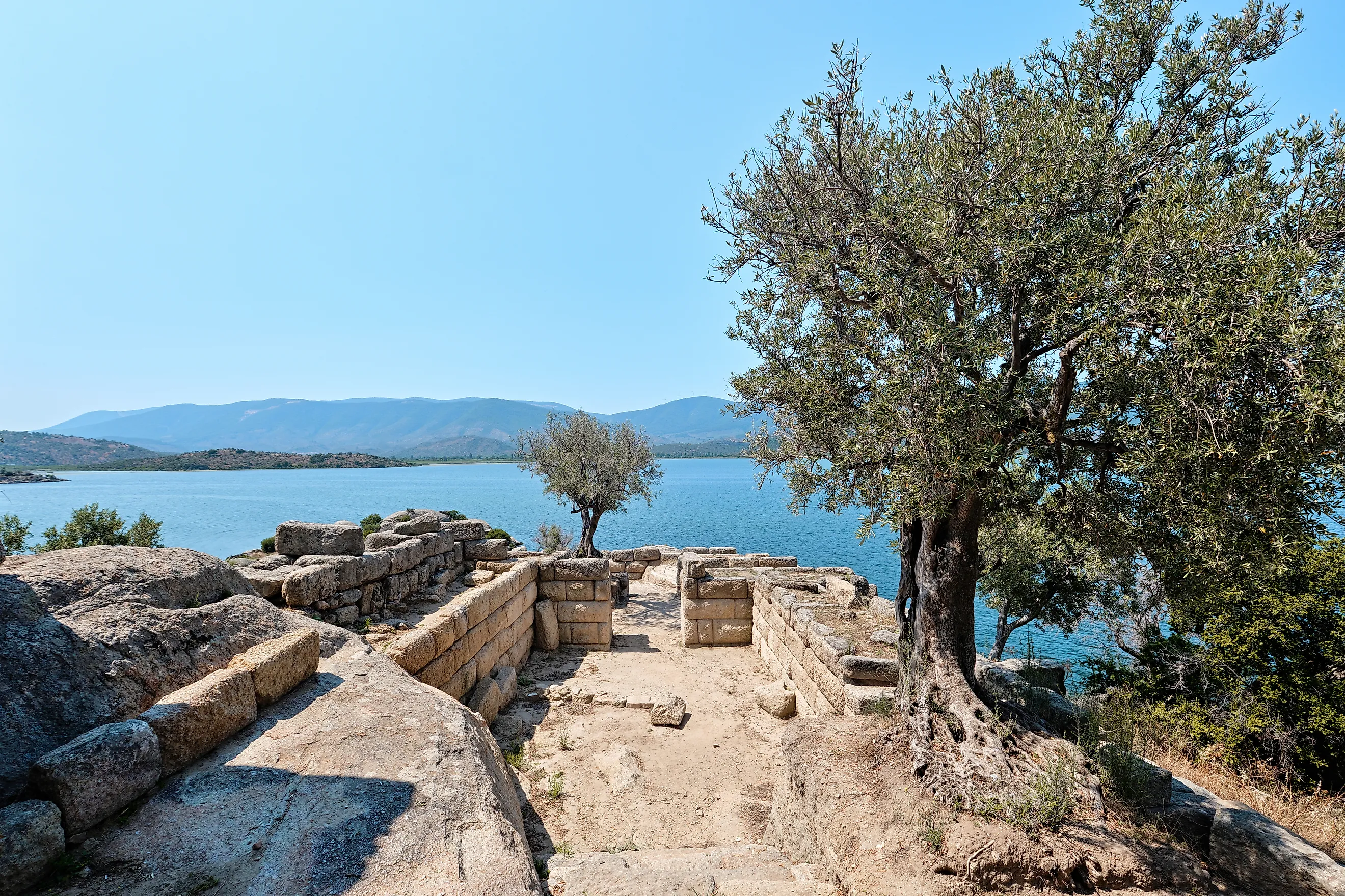
Ancient Egyptians: Lake Moeris (Egypt)

The Egyptians’ mastery of water extended beyond the Nile itself. Around 4,000 years ago, Middle Kingdom rulers expanded Lake Moeris in the depression known as the Faiyum Oasis by enlarging the Bahr Yussef canal that linked it with the river. This engineering allowed excess floodwaters from the Nile to be diverted during inundation and stored for irrigation once the floods subsided. Later, under Ptolemy II in the 3rd century BCE, the lake’s level was deliberately lowered to reclaim fertile land, transforming the Faiyum into one of Egypt’s most productive agricultural zones. Ancient writers noted the region’s distinctive olive groves and wine produced in abundance, portraying the region as a landscape of both innovation and plenty.

The Faiyum’s resources attracted people for millennia, from prehistoric hunters to Greek settlers, leaving behind archaeological traces that span Pharaonic, Hellenistic, and Roman eras. One monument even deified Amenemhat III alongside the crocodile god Sobek, associating both with the life-giving waters of the Nile. Although Lake Moeris has since regressed to the smaller Lake Qarun, the surrounding oasis is still intensively cultivated. Its wetlands still shelter migratory birds, gazelles, and hyenas, while human communities continue to endure as they have for more than 8,000 years. The story of Lake Moeris demonstrates how Egyptian engineering reshaped landscapes, sustained agriculture, and left a legacy that continues to inspire the present.
Maya Civilization: Lake Petén Itzá (Guatemala)

In northern Guatemala’s Petén, the Itza Maya established their island capital Nojpetén on Lake Petén Itzá, which persisted as the last independent Maya kingdom until the Spanish conquest in 1697 CE. Today, the site is known as Flores, a colorful town that serves as a gateway to Tikal National Park, a UNESCO World Heritage site where plazas, ball courts, and pyramids remain. At its height, Tikal was marked by advances in hieroglyphic writing, religious ceremony, and monumental sculpture. The park also protects wetlands, savanna, and palm-rich forests that shelter jaguars, monkeys, anteaters, and more than 300 bird species.

With few perennial rivers, Maya survival depended on collective water management. Communities engineered reservoirs to capture rainfall, dammed hilltops, and cut canals to sustain a population that grew from about 3 million to 13 million over several centuries. Many of these systems were associated with cenotes, natural sinkholes connected to the groundwater network formed by the Chicxulub impact, the very cataclysm that ended the dinosaurs. Lake Petén Itzá was sacred: Underwater excavations have recovered hundreds of artifacts interpreted as ritual offerings, perhaps dedicated to the rain god Chaak, underscoring water was not just sustenance for the Maya but a medium tethering life to the divine.
Prehistoric Pile-Dwelling Communities: Lake Constance (Central Europe)

Long before Europe’s great cities rose, fishing and farming communities clustered around Lake Constance at the edge of the Alps. The town of Constance is unique in boasting three UNESCO World Heritage archaeological sites, part of the wider serial property known as the Prehistoric Pile Dwellings around the Alps. Beginning around 5000 BCE, these early societies built wooden houses on stilts that protected them from flooding while maintaining easy access to fisheries and trade routes. These houses illustrate both careful settlement planning and construction features such as shingled roofs, insulated floors, and tongue-and-groove joints.

The waterlogged conditions of Lake Constance preserved exceptional evidence of daily life. These include foodstuffs such as wheat, bones of domesticated animals, and wild berries; technological progress from stone to copper, bronze, and even iron; and materials like tar used as glue, arrow cases, and the oldest textiles in Europe. Overall, Lake Constance has been critical for understanding how Neolithic peoples transitioned from hunter-gatherer societies to settled farming communities, leaving behind one of Europe’s richest archaeological archives.
Anishinaabe Nation: The Great Lakes (North America)

The Anishinaabe trace their roots to the Council of Three Fires, a confederacy of the Ojibwe, Odawa, and Potawatomi that formed around the Great Lakes long before European contact. Each nation held distinct responsibilities: the Ojibwe safeguarded sacred scrolls and Midewiwin teachings; the Odawa organized hunting and trade; and the Potawatomi tended the council fire around which decisions were made. Agreements were recorded in wampum—tubular shell beads—and at times on birchbark scrolls.

During the summer, Anishinaabe families gathered in lakeshore villages to fish, hunt, and harvest. Food was shared communally rather than for profit, and gift-giving was central at trade fairs, where maple sugar was exchanged for buffalo hides. Wild rice—harvested for only a few weeks each year, where streams entered lakes—was a seasonal staple alongside gardens of corn, potatoes, pumpkins, squash, and beans. Birch bark was fashioned into baskets, coverings for lodgings, and canoes, the preferred mode of transport. Today, ancestral traditions of the Council of Three Fires continue to guide cultural teachings, political alliances, and stewardship of the Great Lakes.
Liangzhu Civilization: Lake Tai (China)

The Liangzhu civilization flourished near Lake Tai in eastern China about 5,000 years ago, placing it alongside Egypt, Mesopotamia, and the Indus Valley among Earth’s earliest complex societies. It is best remembered for its exquisite jade artifacts, especially the cong—a square tube with a circular hollow—that embodied cosmological beliefs and inspired a mascot of the Asian Games. Excavations at the UNESCO World Heritage Liangzhu Archaeological Site have uncovered ceremonial jades, polished stone tools, and agricultural implements such as plows, revealing advanced rice cultivation that supported a thriving population.

Archaeologists have also identified more than 30 dams forming an extensive water conservancy system, evidence of sophisticated hydraulic engineering. The ruins range from small villages to monumental platforms and walled enclosures, marking the rise of state-level social organization and the early foundations of Chinese civilization. Yet this fertile lowland was vulnerable to flooding, as a sudden sea-level rise buried rice fields under silty sediments, leading to the culture’s collapse and dispersal, a reminder that even the most advanced societies remain bound by nature’s rhythms.
Tiwanaku & Inca: Lake Titicaca (Peru/Bolivia)

The Tiwanaku civilization established its capital on the southern shore of Lake Titicaca in the high Andes, flourishing between 500 and 900 CE, centuries before the rise of the Inca Empire. Most Adobe residential quarters were later overbuilt, but the monumental stone ceremonial center remains. Oriented to the cardinal points, it was constructed with precisely carved blocks and equipped with an underground drainage system that channeled rainwater. Among its most iconic remains is the Gate of the Sun, a monolithic doorway carved with a central deity flanked by anthropomorphic birds, often interpreted as an agricultural calendar linking ritual to seasonal cycles.

Since 2012, underwater excavations in Lake Titicaca have revealed the lake’s ongoing sacred role. Archaeologists uncovered an Inca stone offering box containing a miniature shell llama and a rolled sheet of gold, alongside more than 25 submerged sites that include shrines, dwellings, and the earliest known pre-Columbian port. These discoveries highlight how the lake was not only a lifeline in extreme high-altitude but also a spiritual center favored by both Tiwanaku and Inca peoples. Plans for the Museo Subacuático Titicaca aim to display these finds in situ, so the sacred waters continue to reveal their stories to future generations.
Where Lakes Shaped Civilizations
From the floating gardens of Tenochtitlán to the rice paddies of Liangzhu, lakes nourished civilizations physically and spiritually. They provided food, transport, and fertile land, but also symbolism as places of origin, ritual, and memory. While rivers are often regarded as the main cradles of early societies, lakes offered a variant of stability: one that anchored communities and preserved their legacies for millennia. Today, these ancient lakes resonate as cultural landmarks, linking modern nations to their earliest histories, while reminding us that water, in all its forms, has always been the foundation for humanity.


