The Day The Teton Dam Burst
On June 5, 1976, at 11:57 am, the Teton Dam in southeastern Idaho collapsed, sending an enormous flood through communities along the Teton River. The disaster killed 11 people, destroyed hundreds of homes, and caused approximately $400 million in damage. The dam had been built to provide irrigation water, control flooding, and generate hydroelectric power, but it failed during the reservoir's first filling. Investigators later determined that water had eroded material from inside the dam through openings associated with its fractured volcanic-rock foundation. The collapse became a turning point in American dam safety practices.
The Construction of Teton Dam

Built on the Teton River about 12 miles northeast of Rexburg, Idaho, the Teton Dam was intended to store irrigation water, reduce flooding, and generate hydroelectric power. The region had swung between drought and flooding, including a severe drought in 1961 and major flooding in 1962, the year the Bureau of Reclamation recommended the project. Congress authorized it in September 1964, and construction began in February 1972. The earthen dam was designed to stand about 305 feet high, with a crest extending roughly 3,100 feet across the canyon and a reservoir of about 288,000 acre-feet when full. It was meant to supply supplemental irrigation to more than 111,000 acres of farmland in the Upper Snake River Valley, along with flood-control and recreational benefits.
The site, however, presented serious geological challenges. The canyon walls contained highly fractured volcanic rock, particularly welded rhyolitic ash-flow tuff associated with ancient eruptions in the Yellowstone region, and those fractures provided pathways for reservoir water to travel. Engineers tried to seal them by injecting grout, a cement-based mixture, but crews encountered fissures and cavities, some large enough to resemble caves, and the job required more grout than initially expected. Engineers also excavated trenches into the rock beneath the embankment and filled them with compacted soil to stop water from passing through the foundation. Reservoir filling began on October 3, 1975, and the dam was substantially completed that November. The water was supposed to rise about one foot per day, but heavy winter snowfall and spring runoff prompted faster filling, and by May 1976 the reservoir was rising an average of about three feet per day, with a maximum recorded rate of 4.3 feet per day. The accelerated filling raised concerns after the disaster, but later investigations did not identify it as the cause of the collapse.
June 5, 1976: The Morning the Dam Burst

The first warning signs appeared on June 3, 1976, when workers noticed clear water seeping from the ground downstream of the dam, and more seepage appeared the next day. Because the water was initially clear and was emerging from the surrounding rock, it was not considered an immediate threat. On the morning of June 5, however, workers found muddy water leaking near the dam's right abutment, where the embankment met the canyon wall, and more leaks appeared between about 7:00 and 8:00 am. The sediment showed that material was being carried away from the structure or its foundation.
By about 10:15 am, a wet spot had appeared on the downstream face of the dam. The leak grew rapidly, and witnesses reported a loud roar as water eroded the embankment. Workers tried to plug the opening with material pushed by bulldozers, without success. At about 10:43 am, the project construction engineer warned the sheriffs' offices in Madison and Fremont counties of a possible dam failure, and local authorities began alerting downstream communities while workers continued fighting the leak.

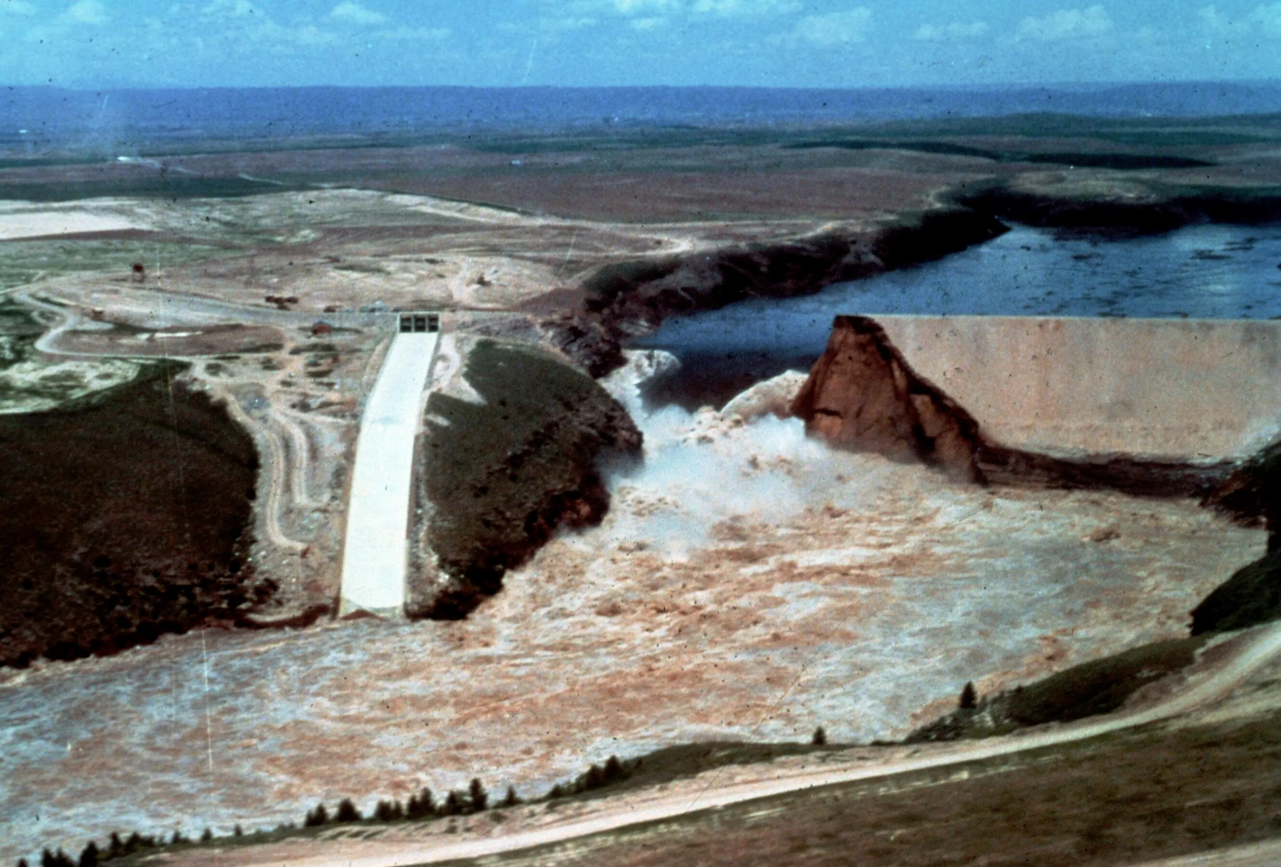
Around 11:00 am, a large whirlpool formed in the reservoir near the right abutment, a sign that water was entering an opening beneath the surface. As the hole expanded, two bulldozers were lost, though their operators escaped. At 11:55 am, part of the dam's crest collapsed into the reservoir, and two minutes later, at 11:57 am, the embankment breached, releasing a torrent of water into the canyon below.
According to the US Geological Survey, the flood reached an estimated peak discharge of 2.3 million cubic feet per second. About 173,000 acre-feet of water escaped through the breach in the first 143 minutes, and roughly 240,000 acre-feet drained from the reservoir over eight hours. The dam's principal outlet works were not yet fully operational, which limited control of the rising reservoir, but the failure was ultimately attributed to internal erosion in the dam's foundation and embankment, not simply to the unavailable outlet works.
The Flood That Devastated Idaho

After escaping through the breach, floodwaters surged down the narrow Teton River Canyon and spread across the Snake River Plain, carrying sediment, boulders, trees, and debris. Near the canyon mouth, the water reached heights of about 16 feet in places. Wilford was among the hardest-hit communities: according to a USGS investigation, 110 of its 154 houses were swept away, another 20 were heavily damaged, and 24 sustained lighter damage. The flood also struck nearby Teton before continuing toward Sugar City and Rexburg.
Sugar City suffered extensive damage as water and sediment swept through residential areas, inundating homes and businesses and leaving thick deposits of mud on streets and farmland that residents had to clear during the recovery. Rexburg, one of the largest communities in the flood's path, experienced widespread inundation, and in parts of both towns flood depths reached about 5 to 16 feet, according to the USGS. Thousands of residents were displaced, and many sought shelter at Ricks College, now Brigham Young University-Idaho.

The floodwaters continued through parts of the Henrys Fork and Snake River valleys until the American Falls Reservoir contained them, preventing their uncontrolled passage farther along the Snake River. The USGS reported that more than 180 square miles were inundated and estimated the damage at about $400 million in 1976 dollars, though other assessments have placed total economic losses higher, depending on the categories of damage included. Estimates of livestock losses ranged from 13,000 to 20,000 animals, and the flood destroyed irrigation infrastructure and damaged roads, railroads, businesses, and agricultural land.
Warnings from local law enforcement, radio stations, and residents helped many people escape before the water arrived, but the disaster still claimed 11 lives and damaged thousands of homes. Recovery began almost immediately. Idaho Governor Cecil Andrus declared an emergency on June 5, and President Gerald Ford issued a federal disaster declaration the following day. Government agencies, religious organizations, and about 40,000 volunteers helped with food, shelter, debris removal, and reconstruction, while Ricks College and local churches played major roles in housing and supporting displaced residents.
What Caused the Teton Dam to Fail?

Following the disaster, an independent panel investigated the dam's design, construction, and geological conditions. Its December 1976 report concluded that the failure resulted from internal erosion, also known as piping, within the dam's impervious core, deep in the foundation trench near the right abutment. Water traveled through openings in the fractured volcanic rock and along the contact between the dam and its foundation, removing fine soil particles from the core and gradually enlarging the passages. Once the erosion progressed far enough, the embankment could no longer withstand the reservoir's pressure, and the failure accelerated rapidly. Investigators identified inadequately sealed joints in the foundation rock as important pathways and also considered whether hydraulic fracturing, a process in which water pressure creates or enlarges openings, had cracked the compacted soil. The precise sequence that started the erosion, however, could not be established conclusively.
The panel found that the design had not adequately accounted for the site's geology or the properties of the soil used in the foundation trench: the fractured rock was difficult to seal, and the fine-grained core material was vulnerable to erosion once water found a pathway through it. The investigation did not conclude that construction crews had simply ignored the approved design. Construction generally followed the design in significant respects, except for scheduling, and the central failure was the design's inability to protect against internal erosion under the conditions encountered on site. Investigators also determined that the dam could have been built safely at the location using engineering methods available at the time, so the disaster was not an unavoidable consequence of building on volcanic rock but rather a failure to adequately account for the site's particular conditions.
The Legacy of the Teton Dam Disaster

The destruction of Teton Dam prompted a major reassessment of dam safety in the United States, helping bring greater attention to foundation geology, seepage control, internal erosion, and the importance of monitoring dams during their initial filling. In 1978, Congress passed the Safety of Dams Act, strengthening the Bureau of Reclamation's authority to investigate and address safety deficiencies at its facilities. The disaster also helped drive the development of Reclamation's Dam Safety Program, which conducts inspections and evaluates risks associated with aging infrastructure, earthquakes, flooding, and structural deterioration.
The remains of Teton Dam are still visible in southeastern Idaho, and the site continues to attract engineers and researchers studying the causes of the failure. Fifty years after the disaster, the collapsed embankment is a reminder of the consequences of inadequate engineering safeguards and of the importance of understanding the geological conditions beneath major water infrastructure.