Dall River
The American Dall River twists and turns through largely uninhabited territory in central Alaska, on its way to its meeting point with the larger Yukon River. While it is not significant as a commercial waterway, the Dall River is instead notable for the natural beauty of the landscape through which it passes. As one of the many examples of geographic naming confusion that exist, there are two separate Dall Rivers in northwestern North America. One of the rivers is in Alaska, United States, and the other is in British Columbia, Canada. The following details the American Dall River.
Source and Course of the River

The Dall River begins its journey on the southwestern slope of Dall Mountain, a 3,281-foot-high mountain in central Alaska, named after the river. While Dall Mountain is about 40 miles northwest of Stevens Village along the Yukon River, the winding Dall River runs for twice that distance, 80 miles, to reach the Yukon about 5 miles west of Stevens Village. As one of the many tributaries of the Yukon, the Dall empties into the third longest river in North America. The Yukon River runs for nearly 2,000 miles westward from the coastal mountains of British Columbia to the Bering Sea on Alaska’s west coast.
Naming the River

The Dall River was named in 1869 by Captain Raymond of the US Army Corps of Engineers, in honor of William Healey Dall. According to Captain Raymond, the river was called "Notochargut," translated as "mouth of the Noto (River),” by the local Native people. The river’s namesake, William Healey Dall, led an exploration of the Yukon River region during the Western Union Telegraph Expedition of 1865-1867, an abandoned effort to complete a telegraph line from San Francisco, California, to Moscow, Russia. While the project failed in its intended goal, it marked the first detailed American exploration of Alaska and may have contributed to the US decision to purchase the land from Russia in 1867.
Geology, Climate, and Wildlife

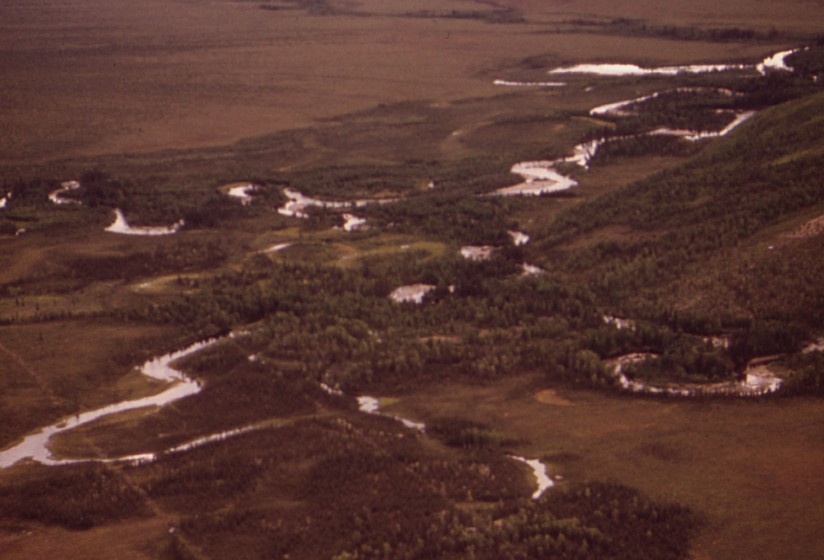
The Dall River, like the larger Yukon River that it feeds into, winds through valleys carved between the mountains of central Alaska. The taller mountain peaks in this area typically reach the range of 3,000 to 5,000 feet, while the lower areas and valleys are partially covered by coniferous forests. The Dall River flows through a subarctic climate, with long, very cold winters and short, warm summers. Wildlife is abundant in the surrounding land, including species like grizzly bears, moose, caribou, wolves, muskrats, and Dall sheep, which are white and have large curled horns. Local birds include swans, geese, ducks, and grouse, and fish include salmon, pike, and whitefish, among others.
Local Populations

The territory along the Dall River has traditionally been very sparsely inhabited, with the vast majority of the few nearby residents being Alaska Natives. The only population center of any size in the vicinity of the river is Stevens Village, located on the Yukon River about 5 miles upriver from the Dall River’s mouth. Stevens Village, also called the Native Village of Stevens, was named in 1902 for one of its founders, an Athabascan Alaska Native known as Old Steven. Stevens Village’s population has shrunk by more than half in the past two decades, to only 37 in 2020, and continues to be comprised almost completely of Kutchin Natives who live a subsistence lifestyle.
Dall River, British Columbia, Canada
This other Dall River is presumably named for the same person, William Healey Dall, as the Western Union Telegraph Expedition passed through British Columbia before reaching Alaska. The Canadian Dall River runs northwest through northern British Columbia, passing through Dall Lake, before emptying into the Turnagain River. Between Dall Lake and the Turnagain River, the Dall River runs through Dall River Old Growth Park, a forested nature preserve among the Cassiar Mountains, which is only accessible by air. Visitors to the park typically fly in on guided hunting or fishing trips. The territory of the park overlaps with traditional use areas of the Kaska Dena and Tahltan First Nations peoples.
The Dall River of central Alaska—and, for that matter, the Dall River of northern British Columbia—passes through a mountainous, forested, sparsely inhabited landscape with abundant wildlife. The Alaskan Dall is not a river utilized much for commerce or tourism, but it is an important component of the surrounding ecosystem as well as the lives of the Alaska Natives who have called the area home for centuries. The isolation of the Dall River is emblematic of the sheer immensity of Alaska.