11 Best Attractions To Visit In The Rockies
The Rockies need no introduction. On their run from northern British Columbia down through Alberta, Idaho, Montana, Wyoming, Utah, and Colorado, they concentrate a density of things worth crossing a continent for. Some are geological accidents that took ten thousand years to form. Some were blasted into cliff faces by engineers who probably should not have attempted it. One is a hotel that looks and feels like a castle. The range holds the largest hot spring in the United States, the highest continuous paved road in the country, and a sheet of ice as thick as the Empire State Building is tall. These are the top spots to hit across the Rocky Mountains.
Moraine Lake, Banff National Park, Alberta, Canada

One of the most photographed lakes in Canada, and the one that used to be printed on the twenty-dollar bill. It sits at 1,884 metres in a glacial bowl called the Valley of the Ten Peaks, and the colour comes from rock flour that glaciers grind off the surrounding mountains and deposit in the water, which refracts light into a blue-green that photographs look like they have been edited. The Rockpile is the essential five to fifteen-minute climb up a natural dam of glacial boulders beside the parking area. Stone and log steps make it manageable for most people, and the view from the top is the classic one. Watch for pikas darting between the rocks.
The Lakeshore Trail runs an easy 1.8 km along the northern shore, and the peak views get more dramatic the further you walk. Consolation Lakes is a 5.8 km return option through boulder fields to a much quieter pair of lakes behind the Rockpile. Personal vehicles are no longer permitted on Moraine Lake Road, so you need the Parks Canada shuttle, Roam transit, a licensed commercial operator, a bike, or a guided tour, and shuttle reservations open in April and vanish fast. There is no cell service, wifi, running water or lighting at the lake, only pit toilets. Watercraft are now prohibited to protect the water. Go on a weekday in late September if you can, when the larches turn gold.
Columbia Icefield and the Athabasca Glacier, Alberta, Canada

The largest icefield in the Rocky Mountains, straddling the Continental Divide between Banff and Jasper national parks. It is guarded by eleven of the range's highest peaks, feeds three of Canada's largest river systems, and its meltwater eventually reaches three separate oceans. The ice on the Athabasca Glacier is roughly 365 metres thick, about the height of the Empire State Building, and around ten thousand years old.
The Columbia Icefield Adventure is the headline experience. You board a purpose-built Ice Explorer, an enormous all-terrain vehicle, at the Glacier Discovery Centre and ride directly onto the glacier, where you can walk on the ice and drink the meltwater. The whole tour runs about two and a half to three hours. The Columbia Icefield Skywalk is included with that ticket. It is a glass-floored platform cantilevered over the Sunwapta Valley, reached by shuttle from the Discovery Centre. Not for anyone with a fear of heights.
For a free alternative, the Toe of the Glacier trail runs 1.8 km return from the parking area to the glacier's edge. Read the year markers along the way showing where the ice reached in past decades; the retreat is sobering. Critically, do not step onto the ice here. The surface near the trail is hollow and cracking over fast-moving meltwater, and only guided groups are permitted on the glacier. Book online in advance during summer, since tours run on timed slots.
Takakkaw Falls, Yoho National Park, British Columbia, Canada

The name comes from a Cree word meaning "it is magnificent," which is not overselling it. Meltwater from the Daly Glacier drops off the Waputik Range into the Yoho Valley in a plume that reaches its full volume in late summer when glacial melt peaks. Sources put the total drop between 302 and 384 metres depending on how it is measured, with a main free fall of 254 metres. Either way it is among the highest waterfalls in Canada.
The falls are reached by Yoho Valley Road, which branches off the Trans-Canada near Field. The road includes tight switchbacks that require vehicles to reverse around the corners, so anything over roughly seven metres is not permitted. The parking area is a short, flat walk from the base, and you will get wet from the spray.
While you are in Yoho, two more stops are within twenty minutes. Emerald Lake has a two-hour shoreline loop and a historic lodge, and the Natural Bridge is a rock span the Kicking Horse River carved straight through solid stone. One important note: all water bodies in Yoho and Kootenay national parks are closed to watercraft and angling until March 31, 2027, to prevent the spread of whirling disease. No canoe rentals at Emerald Lake for now.
Fairmont Banff Springs, Alberta, Canada

Nicknamed the Castle in the Rockies, and a National Historic Site of Canada. William Cornelius Van Horne of the Canadian Pacific Railway had the idea after his employees stumbled on mineral springs in 1883, and he commissioned architect Bruce Price to design something Châteauesque at the confluence of the Bow and Spray rivers. It opened in 1888. The original wooden building burned down in 1926 and was rebuilt in stone.
You do not have to be a guest. The Hotel History Tour runs in the morning and afternoon, led by guides through the public halls, with stories about the architecture and the notable visitors, including King George VI and the Queen Mother during the 1939 Royal Tour. Dining is the other way in. There are twelve restaurants and bars on the property, from the 1888 Chop House to the Rundle Bar with its mountain views, and food tours are available if you want to work through several with commentary. Golfers should know the Stanley Thompson 18 is one of the more famous alpine courses in the world. One practical warning that comes up often enough that the hotel's own tour operators post it: this is in the town of Banff, not Lake Louise. Château Lake Louise is a different Fairmont property and not the Castle in the Rockies.
Going-to-the-Sun Road, Glacier National Park, Montana, United States

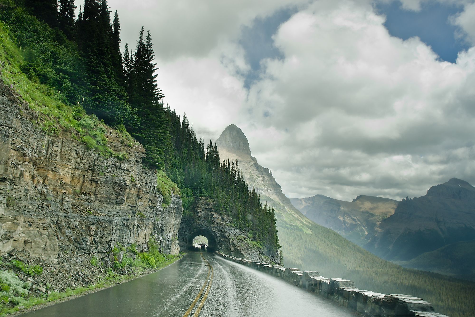
Fifty-two miles of engineering that has no business existing, crossing the Continental Divide at Logan Pass and carved into cliff faces above the valley floor. Crews clear snow across nearly forty avalanche paths each spring, which is why the full road typically does not open until somewhere between mid-June and early July.
Logan Pass at 6,646 feet is the high point, with a visitor centre, restrooms, drinking water and a short boardwalk. The Hidden Lake Overlook trail leaves from there, an easy three-mile out-and-back with wildflowers and frequent wildlife. The Highline Trail is the more serious option, running along the Garden Wall with genuine exposure.
Two 2026 changes matter. Vehicle reservations have been eliminated park-wide, so you can simply drive the road with a valid entrance pass. But from July 1, private vehicle parking at Logan Pass is capped at three hours. If you want a longer hike from the pass, book a ticketed express shuttle on Recreation.gov. Tickets release sixty days ahead and again the night before, and shuttles run July 1 through September 7. Wear layers regardless of the forecast. Conditions at the pass are nothing like conditions at the entrance.
Grand Prismatic Spring, Yellowstone National Park, Wyoming, United States

The largest hot spring in the United States, deeper than a ten-story building, and the colours are alive. The rings of red, orange, yellow and green are mats of heat-loving bacteria and algae, each species thriving at a different water temperature, arranged in bands radiating outward from the scalding blue centre.
There are two ways to see it and you should do both. The Midway Geyser Basin boardwalk is a 0.7-mile loop that takes you right alongside the spring, crossing the Firehole River and passing the Excelsior Geyser Crater on the way. Allow 45 minutes to an hour.
The Grand Prismatic Overlook Trail gives you the aerial view everyone knows from photographs. It starts at the Fairy Falls trailhead about a mile south of the Midway lot, follows an old freight road, then climbs roughly 130 to 200 feet over two-tenths of a mile to a purpose-built platform completed in 2017. Add another 1.6 miles from there and you reach Fairy Falls itself.
Timing is everything. Go at midday when the air is warm, because on cool mornings steam obscures the entire spring. A polarizing filter helps enormously. The Midway lot fills between 10am and 4pm in summer and rangers turn cars away, so arrive before 9am or after 5pm. Carry bear spray on the overlook trail, which passes through dense forest. And stay on the boardwalks without exception; the ground is fragile and the water is boiling.
Jenny Lake, Grand Teton National Park, Wyoming, United States

A glacial lake sitting directly at the base of the Teton Range, dammed by moraines left behind when the glacier that carved Cascade Canyon retreated. From the east shore you look straight up at Teewinot, Mount St. John and the mouth of the canyon. From the west shore you look back over Jackson Hole. The signature outing combines a boat and a hike. Jenny Lake Boating runs shuttles every ten to fifteen minutes across to the Cascade Canyon trailhead, no reservations taken, tickets bought at the east dock. The crossing itself is worth it for the views of Nez Perce and Teewinot.
From the west dock, Hidden Falls is half a mile each way to a 200-foot cascade dropping over rocky ledges. Continue another half mile of steep, rocky, exposed climbing to Inspiration Point, which opens onto the lake, Jackson Hole and the Cathedral Group: Mount Owen, Teewinot and the Grand Teton itself. Views from the overlook are best in the afternoon.
Skip the boat and the same round trip becomes 4.9 miles to the falls or 5.7 to Inspiration Point, following the lakeshore. That is the only option outside mid-June to mid-September when the shuttle operates. Parking at South Jenny Lake is very limited. Arrive before 9am or after 4pm. There are no restrooms past the visitor centre.
Trail Ridge Road, Rocky Mountain National Park, Colorado, United States

Forty-eight miles across the top of the park, connecting Estes Park and Grand Lake, cresting at 12,183 feet. It is the highest continuous paved road in the United States, and eleven of those miles run above treeline with no guardrails and steep drop-offs. When it opened in 1932, an early Park Service director predicted it would cause a sensation. It still does. Driving it end to end takes about two hours without stopping, which nobody does. Pull off constantly. Rainbow Curve, Rock Cut and Forest Canyon Overlook are the classic stops, and the Alpine Visitor Center at 11,796 feet is the highest facility of its kind in the national park system.
What makes this different from other scenic drives is the ecosystem. You climb through montane forest into subalpine and then out onto genuine alpine tundra, the same environment found in the Arctic. Ground-hugging wildflowers bloom across it in mid-summer. Elk, bighorn sheep and marmots are all regular sightings.
For a rougher, older alternative, Old Fall River Road opened in 1920 as the park's first high-country route. Eleven miles of one-way gravel, no guardrails, 15 mph limit, joining Trail Ridge at the Alpine Visitor Center. The road is seasonal and closes with snow. Timed entry reservations are generally required between 9am and 2pm in summer, and the park runs a recorded status line at (970) 586-1222.
Maroon Bells, Colorado, United States

Two 14,000-foot peaks, Maroon Peak and North Maroon Peak, reflected in Maroon Lake with an aspen grove in the foreground. It is routinely called the most photographed mountain scene in North America, and the maroon colour comes from mudstone rather than the granite that makes up most of the range.
The reflection shot happens at Maroon Lake, a short flat walk from the trailhead, and it works best at sunrise when the water is still. Crater Lake is a 3.6-mile round trip further in, gaining about 500 feet and putting you directly beneath the Bells. Late September brings the aspens in, which is when the crowds peak alongside them.
Access is managed tightly. The Maroon Bells Scenic Area is closed to inbound private vehicles from 8am to 5pm between May 22 and October 18. Most people take the shuttle, which departs from the Maroon Bells Welcome Center at Aspen Highlands Ski Area and takes about fifteen minutes each way. There is paid parking at the welcome centre with no reservation needed, though oversized vehicles are not permitted and free lower-cost parking exists a short bus ride away.
If you want a sunrise or evening visit, book a trailhead parking reservation instead, arriving before 8am or after 5pm. Spaces are very limited. A warning worth taking seriously: the Bells are known as the Deadly Bells among climbers. The rock is loose, downsloping and rotten, and the standard routes have killed experienced mountaineers. Admire them from the lake.
Redfish Lake, Sawtooth National Recreation Area, Idaho, United States

The largest lake in the Sawtooths, a long banana-shaped alpine lake at 6,547 feet with Mount Heyburn and the Grand Mogul rising directly off the far shore. It is named for the sockeye salmon that once returned here in numbers dense enough to turn the water red. As late as the 1950s more than four thousand made the 900-mile run from the Pacific each year. In recent years the number has often been in the single digits, and a hatchery programme now works to restore the run.
The hiker boat shuttle run by Redfish Lake Lodge is the key to the area. It crosses from the marina at the north end to the Redfish Inlet trailhead at the south, saving up to six miles of walking each way and dropping you at the edge of the Sawtooth Wilderness. Boats leave on demand with two or more people, returning at set times through the day.
From the inlet, the trail to Alpine Lake climbs through boulder fields and switchbacks to a genuine high-country lake with camping on its shores. Self-issued wilderness permits are available at the trailhead. Back at the lake, there are white sand beaches, a swimming area near Point Campground, and boat, kayak and paddleboard rentals at the marina. Five Forest Service campgrounds ring the shoreline. The lodge itself is seasonal, with a restaurant and cabins, and runs Music on the Lawn through summer. Redfish is five miles south of Stanley on a paved road off Highway 75.
Radium Hot Springs, Kootenay National Park, British Columbia, Canada

Canada's largest mineral hot springs pool sits in a narrow limestone canyon at the southern entrance to Kootenay National Park, where the walls of Sinclair Canyon close in so tightly the highway passes through a gap in the rock. The water emerges odourless, which is unusual for hot springs, and holds a steady temperature in the high 30s Celsius. There are two pools: the hot pool for soaking and a cooler swimming pool alongside it. Swimsuits and towels can be rented on site, which makes this an easy spontaneous stop rather than something you have to plan around.
The setting is the reason to choose this over other soaks. Red rock walls rise directly above the water on both sides, and bighorn sheep are regularly visible on the ledges around the canyon. Nearby in the same park, Marble Canyon and the Paint Pots make excellent half-day additions, the first a series of deep gorges cut by glacial meltwater, the second ochre-coloured mineral springs long used by Ktunaxa people.
Moraine Lake, the Columbia Icefield, Takakkaw Falls, Radium and the Banff Springs all fall within a few hours of each other in the Canadian Rockies, and you could reasonably see most of them in a week. Glacier and Yellowstone connect through Montana and Wyoming. Redfish Lake sits off on its own in central Idaho, which is precisely why it stays quieter than the rest. And nearly everything on this list now runs on some form of reservation, shuttle or timed entry, so the single most useful thing you can do is check the official site the week before you leave rather than the month before.