10 Most Scenic Drives in California
There are nearly 400,000 miles of roadway in California, making it one of the best states to explore by automobile. There are rugged coastlines along the Pacific Ocean, dramatic mountain ranges, such as the Sierra Nevada and the southern portion of the Cascade Range, and vast, arid deserts. There are also verdant coniferous forests, and a few hours' drive can take you through many dramatically different ecosystems, each brimming with its own breathtaking scenery.
Whether you’re indulging in nostalgic Americana along Route 66, watching the sunset along the Pacific Coast Highway, or winding through some of the largest trees in the world along the Kings Canyon Scenic Byway, the state is full of unforgettable road trips. These scenic drives are a great way to see some of the most picturesque destinations in California.
Pacific Coast Highway (CA State Route 1)

This stretch of the Pacific Coast Highway (PCH) is one of the most iconic drives in the country for good reason. Hugging the Pacific for more than 650 miles from Dana Point in the south to Leggett in the north, this route will take you past numerous small towns, as well as Big Sur, the famous stretch of rugged California coastline where the Santa Lucia Mountains meet the ocean.
One must-see attraction is the Old Santa Barbara Mission, established in 1786 by Franciscan monks. It features gardens, guided tours, and a historic cemetery. If you’re looking for beaches, Pismo Beach in San Luis Obispo County is a great place to take in the turquoise water and miles of sandy coastline.
Bixby Bridge in Big Sur is located about 15 miles south of Carmel-by-the-Sea, one of California’s most lovely coastal towns. Spanning a rugged canyon, the bridge is one of the most photographed places in the US and a great place to stop and enjoy the majesty of this extraordinary coastal region.
Driving the PCH from end to end will take at least 12 hours, and it can take a week or two to fully explore the stops along the way. Travelers should always check road conditions with the California Department of Transportation, as sections of the road, particularly in Big Sur, are prone to dangerous landslides and road closures.
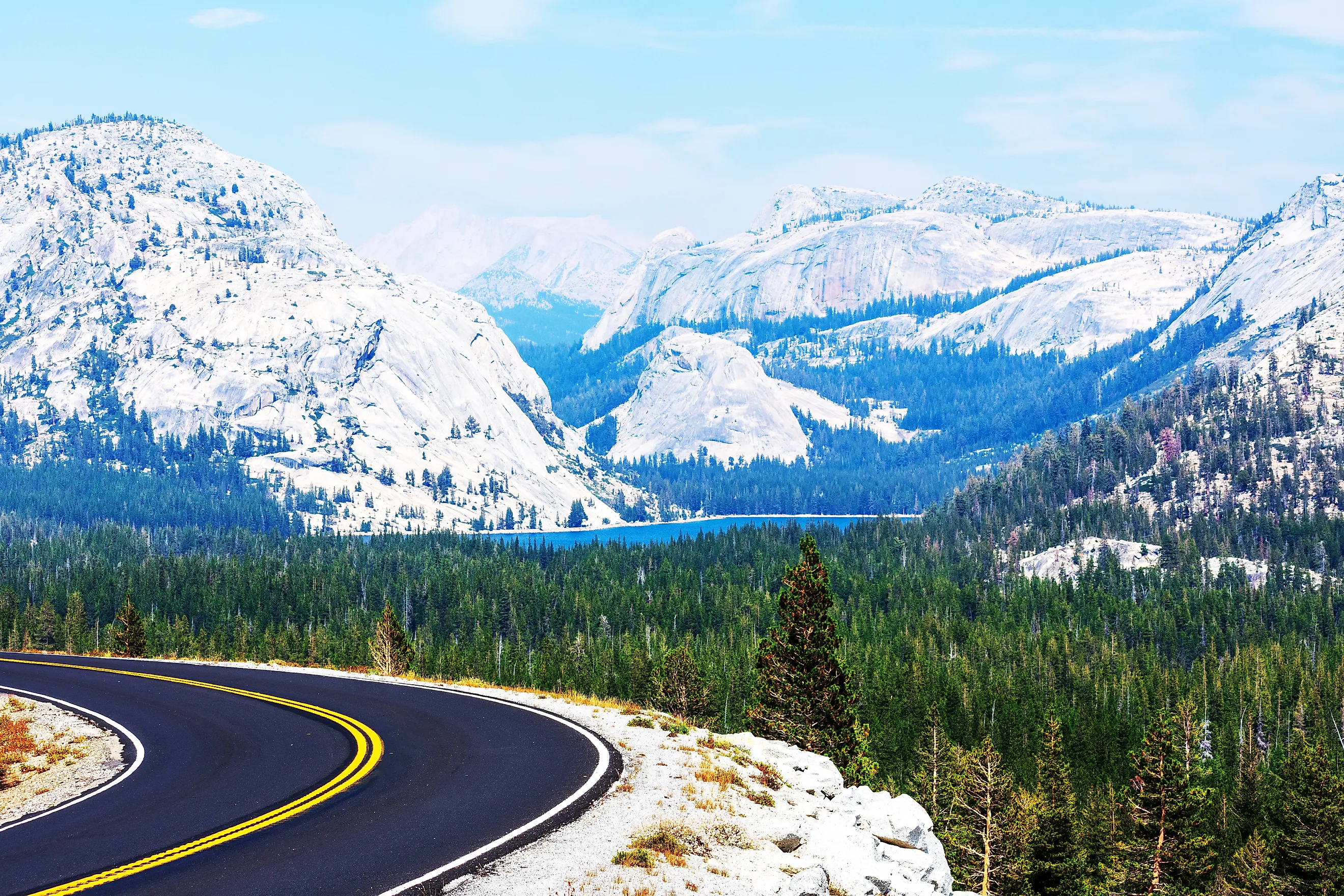
Tioga Pass Road (State Route 120)

Starting at Lee Vinning in eastern California, just a few miles from the Nevada border, Tioga Pass Road serves as the eastern portal for drivers looking to enter Yosemite National Park, one of the state’s most visited destinations. The portion of the road that crosses Tioga Pass at Yosemite’s eastern boundary is the highest paved road in state. While this means that the views are spectacular, travelers should always check the road status before setting out, as the road is often closed during the winter season or after heavy snowfall.
Traveling east from Route 395, you’ll wind your way through miles of scenery, including three breathtaking lookouts at Lee Vinning Creek, Ellery Lake, and Tioga Lake before reaching the Tioga Pass Entrance Station to Yosemite. You will need to pay a park entrance fee (currently $35) to drive Tioga Road past this point. Continuing through the park, will take you through Tuolumne Meadows, a vast subalpine meadow full of lakes, rivers, and mountain peaks. Just past Tenaya Lake, pull off at Olmstead Point for views of the Yosemite Valley, including the north side of Half Dome and Tenaya Canyon. Be sure to stay alert and obey the posted speed limit, as it is not uncommon for black bears to cross the road in the park.
US Route 395

This multi-state thoroughfare runs from the Canadian border in eastern Washington, along the eastern side of the Sierra Nevada mountain before joining with Interstate 15 in the Mojave Desert near Victorville. Along the way, it passes access roads to several national parks including Yosemite, Kings Canyon, and Sequoia, as well as ski resorts, ghost towns, alpine lakes, and historical landmarks.
Driving from the Lake Tahoe area, you’ll pass Mono Lake, an ancient alpine lake known for its tufa formations: tall limestone spires jutting out of the smooth surface of the water along the shoreline. Birdwatchers may be able catch glimpses of ospreys and owls nesting atop the spires. Further south in the Mammoth Lakes Region, take a short detour to the Minaret Vista for sweeping views of the distinctive Ritter Range. The area is also a popular spot for stargazing, and Mammoth Mountain is one of the best ski areas in the state.
Stop in Lone Pine for staggering views of Mount Whitney, the highest peak in the continental US, and a visit to the Museum of Western Film History to learn about the area’s connections to the western genre in film and television. If you want to add a little desert onto your road trip, you can get to Death Valley National Park by taking CA 136 just south of Lone Pine.
US Route 66

One of the most iconic highways in the country, Route 66 turns 100 this year, making it an excellent time to explore the "Main Street of America." Stretching nearly 2,500 miles from Chicago to Santa Monica there are hundreds if not thousands of stops and attractions to check out along this historic route, and driving the whole stretch can take weeks.
The California section runs 314 miles from the desert town of Needles near the Arizona border, through the Mojave Desert, San Bernardino, and Los Angeles before ending at the Santa Monica Pier on the Pacific Ocean. Along the way, you can see several relics of Americana like the El Garces and Aztec Hotels and the Cucamonga Service Station that provide a window into the history of American automobile travel.
The McDonalds Museum in San Bernardino, built on the site of the original restaurant, is full of memorabilia from the history of the iconic fast-food chain and provides a visual timeline of the development of the brand. The desert ghost town of Amboy is another interesting stop where you can see the remnants of the road’s heyday. Hiking up to the otherworldly Amboy Crater is a great way to stretch your legs and view the stark geography of the region.
El Camino Real

Also known as the California Missions Trail, this 600-mile route, is one California’s first long-distance paved highways. This commemorative auto trail roughly follows the path of US Highway 101 and links all 21 Spanish missions in the state from Mission San Diego de Alcala in the San Diego to Mission San Francisco Solano in Sonoma, just north of San Francisco. As you drive along keep an eye out for the cast metal bells that mark the route from beginning to end.
While exploring the missions is a fascinating way to learn about California’s history as an outpost of the Spanish Empire, the route is also full of adorable seaside towns, world class wineries, and some of the best beaches in the country. The Royal Road will take you through Napa Valley, the vinicultural capital of the country, where options for vineyard excursions are endless.
Pinnacles National Park in Soledad is an excellent hiking destination where you can catch a glimpse of the endangered California Condor nesting in the tall rock spires. Try your hand at surfing in the seaside village of La Jolla, just north of San Diego, or take a detour to watch the sunset over the Pacific from the Pigeon Point Light Station outside of San Jose.
Redwood Highway (US Route 101)

While Highway 101 traverses almost the entire Pacific Coast from Los Angeles to Seattle, the 350-mile stretch in Northern California known as Redwood Highway is one of its most beautiful areas. Beginning in San Francisco, the route will take you over the iconic Golden Gate Bridge into Marin County. Make sure to stop at the North Vista Point for one of the best views of the bridge, the city skyline, and San Francisco Bay.
Continuing north to Mendocino County, stop in Willits to experience to old-growth redwoods on the Skunk Train, a historic railroad built during the logging boom in the 19th century. You can pedal along the railway in a two-person railbike or ride the train into Noyo River Canyon where you can see the Wolf Tree, one of the oldest trees along the route.
To explore the redwoods from the comfort of your automobile, Avenue of the Giants in Humboldt County is a 31-mile stretch, often called the best forest drive in the world. Along this route, you can drive right through the trunk of the Shrine Drive-Thru Tree for a good photo opportunity.
Past the port city of Eureka, the road hugs the coast more closely and continues through Redwood National and State Parks, providing ample hiking opportunities for travelers looking to explore the Redwood forests on foot. While Redwood National Park does not have an entrance fee, some of the state parks do. Check the individual park websites for information about fee requirements.
Park Boulevard (Joshua Tree National Park)

Park Boulevard is the main route through Joshua Tree National Park in southern California. This 25-mile loop road connects the park’s north entrance near Twentynine Palms to the west entrance at the town of Joshua Tree, both of which lie along Highway 62. The route can be traveled in about an hour for a quick tour of the park or extended into a longer adventure for those who want to take their time. You will need to pay a national park entry fee (currently $30) to drive any section of the road.
This scenic drive will take you through Joshua Tree groves and pass by several of the most famous rock formations in the park including Skull Rock, Arch Rock, and Barker Dam. Keys View, perched atop the Little San Bernardino Mountains is a popular overlook for watching the sunset, or simply taking in the panoramic views of the Coachella Valley. If you want to extend your trip in Joshua Tree, you can easily add in a trip along Pinto Basin Road to explore the lower elevations of the Colorado Desert. The Cholla Cactus Garden is another popular stop along this section; it's a great place to watch the sun rise as the morning light begins to glow in the spines of cacti.
Volcanic Legacy Scenic Byway

This All-American Road travels along the volcanic Cascade Range in Northern California and connects Lassen Volcanic National Park to Crater Lake National Park in southern Oregon. The entire scenic byway totals roughly 500 miles and passes by several active volcanoes as it winds its way through dense, mountainous forest, broad wetlands, and expansive lava flows.
The California section begins in Lassen Volcanic National Park where travelers can drive past craggy volcanic peaks, vast wildflower meadows, picturesque lakes, and bubbling hot springs. Visitors will have to pay an entrance fee (currently $30) to drive this section of the route. North of the park in Siskiyou County, you’ll pass by the towering, snowcapped Mount Shasta, the second highest peak in the Cascades.
If you love the view of the mountain, don’t worry; on a clear day, Mount Shasta is visible from many points along the byway. Before crossing the border into Oregon, stop at Lava Beds National Monument to explore an astonishing network of caves, Native American rock art, and historic battlefields in the rugged high desert wilderness.
Death Valley Scenic Byway (State Route 190)

This National Scenic Byway is the gateway to Death Valley National Park, the largest national park outside of Alaska. Covering 3.4 million acres in the Mojave Desert, the park contains Badwater Basin, the lowest point in the US, and is the site of the hottest recorded temperature in the world. This route will take you from Highway 395 in Olancha through the park before intersecting with State Route 127 in Death Valley Junction.
One of the first attractions along this route is Mesquite Flat Sand Dunes, towering mounds of sand dotted with gnarled mesquite trees, set against a dramatic mountain backdrop. While the area might look barren, it is the desert habitat of hardy creatures like the kangaroo rat and the sidewinder rattlesnake, so watch your step when exploring.
Just before reaching Furnace Creek, stop at the Harmony Borax Works to learn about the area's mining history and view the ruins of a 19th-century borax plant. About 15 minutes east of the Furnace Creek Visitor Center, Zabriskie Point provides a scenic overlook of the sprawling valley floor and is a popular spot to watch sunrises and sunsets.
Because of the harsh, arid environment and the geographic isolation, it is important to be prepared before entering the park. Make sure to bring plenty of drinking water and emergency supplies, as well as downloaded or paper maps since cell service in the park can be unreliable. It is best to visit from late fall to spring, when the daytime temperatures are more forgiving.
Kings Canyon Scenic Byway (State Route 180)

This 50-mile section of State Route 180 provides access to Kings Canyon National Park coming east from Fresno. Starting near Grant Grove, the steep, winding road travels through sequoia groves and oak chapparal down into one of the deepest canyons in the country, providing incredible views of the sheer granite cliffs and the Kings River before ending in Cedar Grove, a popular area for beginning backcountry adventures.
One of the most visited sites along the route is the massive General Grant Tree near the Kings Canyon Visitor Center. A short loop trail provides access to the 268-foot-tall sequoia, and its location near the visitor center makes it a great first stop for visitors to the park. Further down in the canyon, stop at Boyden Cavern for a guided tour of the amazing marble cave full of geologic formations. Once you reach the floor of the canyon, the road is lined with several pullouts featuring short, scenic hikes including Grizzly Falls and Rolling River Falls.
Also worth a stop is Zumwalt Meadows, which is accessed via a relatively short trail that crosses the Kings River. The stunning meadow offers panoramic views of the surrounding steep canyon walls and is a great place to look for wildlife like yellow-bellied marmots and various birds of prey.
On California's Scenic Roads, Beauty Lies Around Every Bend
Whether you're learning about the state's historic missions or exploring some of the country's most treasured national parks, California's scenic roads provide access to breathtaking scenery and one-of-a-kind experiences. From the Pacific Coast to the highest peak in the continental US, along lonely desert roads and winding canyon switchbacks, each twist and turn reveals more of the beautiful scenery that makes California one of the best road trip destinations in the country.