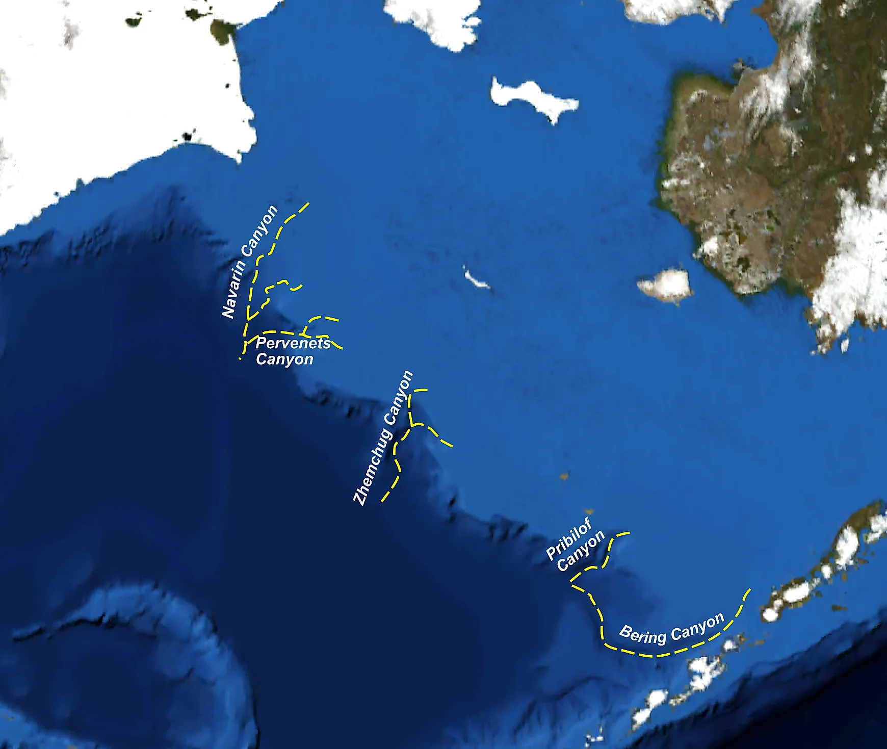
The Underwater Canyons Off The US Coast
The Grand Canyon is the standard picture of a deep chasm carved into the Earth. But some of the planet's largest canyons are hidden entirely underwater, off the very coastlines Americans swim from every summer. The United States' undersea territory holds dozens of these submarine canyons, cut into the continental shelf by ancient rivers, sediment avalanches, and ice-age floods. Several are deeper, wider, or longer than anything on dry land.
Unlike land canyons filled with air, the underwater versions are far from empty. Cold-water corals, whales, octopuses, and fish thick enough to support entire commercial fleets all depend on the food and shelter these canyons provide. Among them are a Bering Sea trench larger than the Grand Canyon by volume and a Southern California canyon scuba divers can enter from shore. Each formed differently and supports marine life NOAA and university researchers are still cataloging.
Zhemchug Canyon

Hidden beneath the Bering Sea between Alaska and Russia, Zhemchug Canyon is widely considered the largest submarine canyon on Earth, ranking above better-known contenders when measured by total volume and drainage area rather than length alone. It stretches 99 miles and drops with a vertical relief of about 8,530 feet, deeper than the Grand Canyon's 6,093 feet. Its drainage basin covers more than 4,380 square miles and holds an estimated 1,390 cubic miles of space, carved into the edge of the Bering Sea's continental shelf near Alaska's Pribilof Islands.
The canyon sits within US waters and forms part of one of the richest fishing grounds in the country. It supports populations of red king crab, halibut, and pollock that feed off nutrients pulled up from the deep by the canyon's steep walls. Despite its record-setting scale, Zhemchug is still one of the least visited and least studied canyons in US waters. Simply because of how remote and hostile the surrounding Bering Sea can be for research vessels.
Monterey Canyon

Monterey Canyon is the largest submarine canyon on the US Pacific coast and one of the most studied canyons in the world, thanks largely to its neighbor, the Monterey Bay Aquarium Research Institute. It is just offshore from California's Monterey Bay and runs around 95 miles from its head near Moss Landing out to the deep abyssal plain. It reaches a maximum depth of about 11,800 feet, with walls rising a full mile from floor to rim in places, on par with the Grand Canyon's.
Rather than a river cutting downward, Monterey Canyon was carved largely by turbidity currents, underwater avalanches of sand, and sediment that periodically storm down the canyon at speeds topping 20 miles per hour. Researchers still debate its deep origins, with one leading theory that it may be the drowned remnant of a river system that once drained California's Central Valley. Whatever the origins, today its walls host sponges, deep-sea corals, and anemones. The water column above is famous for the crimson, camouflaged bloody-belly comb jelly.
Hudson Canyon

About 100 miles southeast of New York City, Hudson Canyon is the largest submarine canyon along the entire US Atlantic coast, plunging to depths of 2 to 2.5 miles and stretching about 7.5 miles across at its widest point. It was carved in part by the ancestral Hudson River during past ice ages, when sea levels were far lower and the river's mouth sat much farther out on the continental shelf than today's New York Harbor.
NOAA proposed designating the canyon as a national marine sanctuary in 2022, and as of 2026 that designation is still working through federal environmental review. The canyon supports a diverse ecosystem including sperm whales, sea turtles, deep-sea corals, and octopuses. A 2014 survey using data from NOAA's Okeanos Explorer found at least 50 previously unknown methane seeps bubbling from its walls. It was part of a broader discovery of more than 570 seeps along the northern Atlantic margin that scientists had no idea existed before 2012.
Norfolk Canyon

Norfolk Canyon cuts into the edge of the continental shelf off the Virginia coast, about 100 miles offshore, and plunges past 4,590 feet at its deepest point. It was one of the seep sites swept up in that same 2012 to 2014 Atlantic margin survey that put Hudson Canyon's methane plumes on the map. The canyon turned out to be unusually rich in life. A 2012 NOAA expedition found live corals, both soft octocorals and hard scleractinian species, on every single one of its 12 research dives.
Bat stars, brittle stars, and sponges cling to the canyon's steep walls alongside those corals. At least nine documented shipwrecks rest within its boundaries, a reminder of how close Norfolk Canyon is to some of the busiest shipping lanes on the Atlantic coast. Researchers have also found lost fishing gear and plastic debris collecting in the canyon, proof that even a formation this remote is not beyond the reach of human impact.
DeSoto Canyon

In the Gulf of Mexico, around 60 miles off the coast where Florida meets Alabama, DeSoto Canyon cuts more than 3,000 feet into the Gulf's gently sloping continental shelf. The canyon acts as a natural chute, funneling cold, nutrient-rich deep water up toward the surface and helping sustain fish populations, corals, and even endangered whales in the surrounding Gulf.
NOAA and academic research teams have documented black corals, bubblegum corals, glass sponges, squat lobsters, and cusk eels living along its slopes. Many of those same coral colonies were damaged by the 2010 Deepwater Horizon oil spill. DeSoto Canyon has since become a key site for tracking how slowly, or whether, centuries-old deep-sea corals in the Gulf of Mexico can recover from that kind of damage.
Astoria Canyon

Off the Pacific Northwest coast, Astoria Canyon begins just 10 miles west of where the Columbia River empties into the ocean and drops to depths beyond 4,265 feet at its axis. Much of the sediment that shaped the canyon's course arrived during the Missoula Floods, a series of catastrophic ice-age floods that repeatedly drained a glacial lake across the Pacific Northwest and dumped enormous volumes of sediment down the Columbia River and out to sea.
NOAA researchers exploring the canyon in 2001 documented steep walls marked by slump blocks, rockfall caves, and a dense community of gorgonian and black corals, alongside commercially valuable species like sablefish, Dover sole, and thornyheads. The canyon's proximity to the Columbia River mouth also makes it an important habitat corridor for species that move between the river's estuary and the deep Pacific.
Scripps and La Jolla Canyon

Reaching this one does not require a research vessel. The La Jolla Canyon system, and its smaller tributary, Scripps Canyon, are just offshore of San Diego's La Jolla neighborhood. Close enough that scuba divers regularly swim out from the beach to explore its rim. Scripps Canyon alone stretches about a mile and reaches a maximum depth of 1,600 feet before joining the larger La Jolla Canyon further offshore.
Its walls host rockfish, sea cucumbers, gorgonian corals, and native swellsharks. Its accessibility has made it one of the best-studied submarine canyons in the world thanks to its location beside the Scripps Institution of Oceanography. It even has a place in space-adjacent history. In 1965, the US Navy's SEALAB II program housed aquanauts, including astronaut Scott Carpenter, in an underwater habitat anchored at 205 feet in the canyon for stretches of 15 days at a time.
Canyons Worth Knowing About
None of these canyons look anything like the sun-baked, colorful walls of the Grand Canyon, but each one proves the same point. Some of the country's most extreme landscapes are simply underwater, out of sight of everyone except the researchers, divers, and remotely operated vehicles that go looking for them.
Sheer size is only part of what makes these submarine canyons remarkable. Deep-sea corals, methane seeps, and other marine life continue to turn up during research expeditions, and parts of the seafloor are accessible to trained divers. American geography does not stop at the waterline. It continues far below the surface, deeper than most people ever think to look.