Best Fall Hikes In Michigan
Michigan is a state of extreme seasons. Summers are hot and bustling with beach-seeking tourists, while winters bring heavy snows and cabin-fever-inducing cold snaps. But in-between is a sweet-spot shoulder season. Fall turns the sprawling forests into a photographer's dreamscape while keeping temperatures at a manageable range – some might even say cozy. This makes it the perfect time to slap on a comfortable sweater and a rugged pair of canvas pants, pack a thermos full of hot coffee, and set forth onto the uncrowded trails. Across the two peninsulas, the coastlines of the four Great Lakes, and a plethora of islands, there are many hikes to choose from. These are some of the best routes, both structured and unstructured, to check off before that notorious Michigan winter sinks its teeth in.
The Routes Of Mackinac Island

This lovely little island is anchored between Michigan's Upper and Lower Peninsulas, at the meeting point of the waters of two Great Lakes (Lake Huron to the East and Lake Michigan to the West). Eighty percent of this 4.35-square-mile patch of land is composed of Mackinac Island State Park, and the entire rock is car-free – making it particularly friendly for locomoting pedestrians. Explore the 8.2-mile-long perimeter road for a full dose of those refreshing fall-breeze shorelines, or head inland, to the network of crisscrossing nature trails through wooded areas filled with points of interest. There are natural rock formations and caves, such as Sugar Loaf, Skull Cave, and Arch Rock, the military outposts of Fort Mackinac and Fort Holmes, and invigorating viewpoints, such as Point Lookout and Sunset Rock, to break up the unstructured meander.
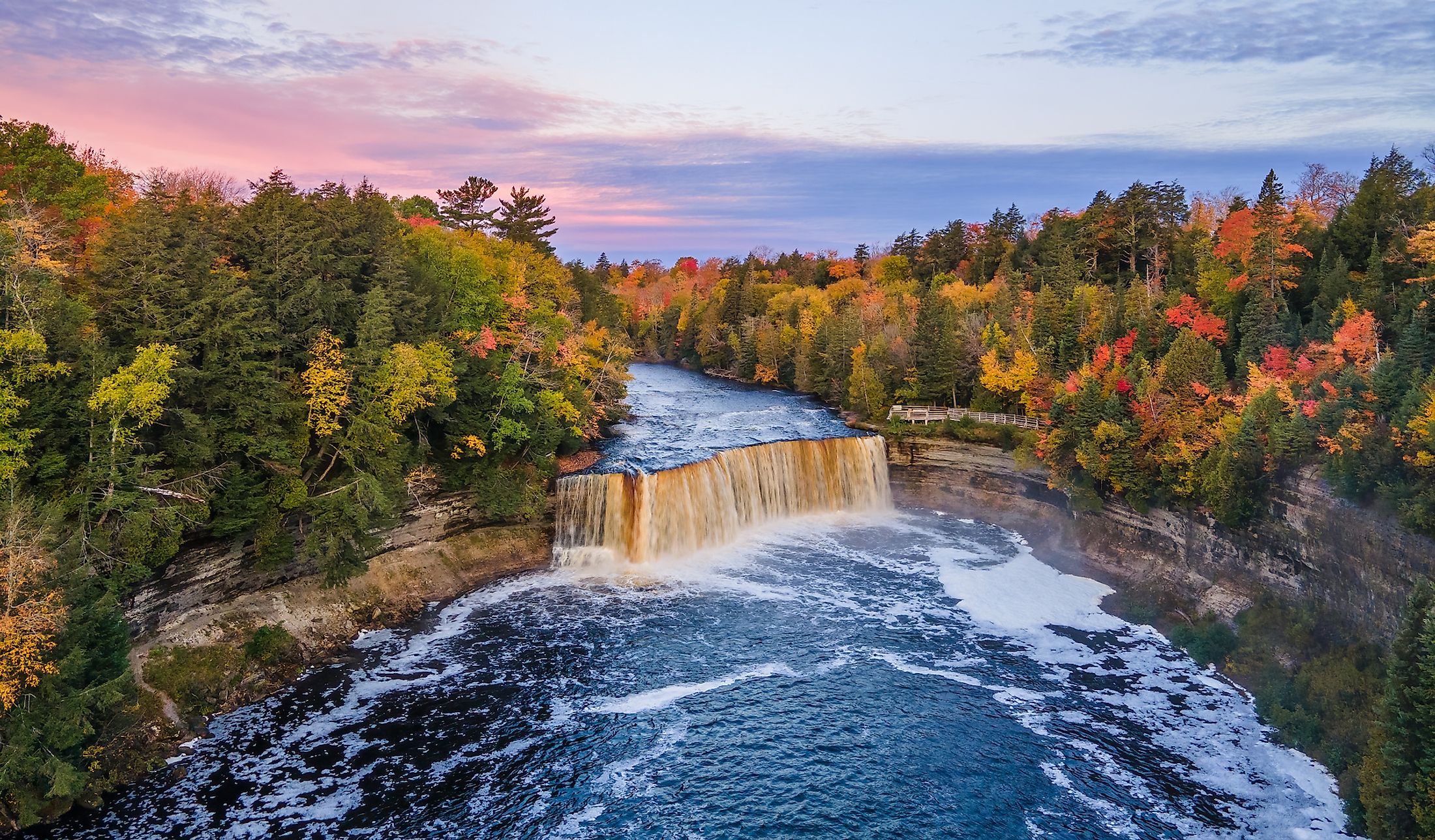
Tahquamenon Falls River Trail

At 50,000 acres, Tahquamenon Falls State Park is Michigan's second-largest park. It unfolds just West of the unincorporated municipality of Paradise, on the East side of the Upper Peninsula. There are 35 miles of trails to choose from, but the 5-mile River Trail is tough to beat. It connects the centerpiece 50-foot tall, 200-foot-wide Upper Falls to the Lower Falls while following the Northern shore of the Tahquamenon River. The trail is both hilly and filled with toe-snagging roots, which adds some difficulty to the hike, but the journey between waterfalls is also enhanced this time of year thanks to the mix of changing colors and obstinate greens, and robust sounds of the rushing waters, unimpeded by the chatter of the summertime crowds.
Sugarloaf Mountain Trail

For a bird's-eye-view of the fall scenery, boot up Sugarloaf Mountain. Located on the Northern shore of the Upper Peninsula, this 470-foot hunk of granite delivers endless views of the foliage mosaic, contrasted by the deep blue waters of Lake Superior – the largest lake in the world in terms of area (third-largest by volume). To the South, hikers will also be able to spot the small city of Marquette, and to the Southeast, the peninsular Presque Isle Park. From the parking lot, there are two main options for getting to the summit: a short, steep grunt, or a slightly longer, smoother affair. In either case, it is a fairly quick round-trip. In fact, the two trails can be combined to form a loop in under an hour (not including the time spent marveling from the top).
Greenstone Ridge Trail

If a longer, wilder excursion is what you seek, work your way up to Isle Royale National Park before it closes for the season on October 31st. At 132,018 acres (not including the marine portions), this is, by far, the largest park in Michigan. It is also one of the least-visited national parks in the United States, having received only 25,452 visitors last year. This is due to its remote location (the island sits just below the Canadian city of Thunder Bay, Ontario, towards the Northern shore of Lake Superior), generally inaccessibility (the only way to set foot on these lands is to hitch a ride on a boat or seaplane), and because of the minimal infrastructure on the wild island. With that said, there are hundreds of miles of maintained trails, 40 of which constitute the Greenstone Ridge Trail. This multi-day trek will provide the outdoor-savvy with stellar panoramic views, and an extended immersion into a truly natural landscape that may have already welcomed its first snowfalls (better hurry!).
Belle Isle Park

Not all Michigan adventures require an odyssey into the deep woods. Belle Isle splits the Detroit River, providing a sanctuary for residents of the Motor City. Start with a lap or two around the perimeter for rotating views of Detroit, and Windsor, Ontario, Canada, as well as Belle Isle Beach, and if you time it right, the aptly-named Sunset Point. Then, cut through some of the interior nature trails, or take the Blue Heron Lagoon Trail to forget about modern metropolises and reconnect with the birds and the trees for a moment. The fallen leaves will cushion your footfall and create an entrancing, almost uniform aesthetic in all directions. If the weather takes a nasty turn, dip into the Anna Scripps Whitcomb Conservatory, or the Dossin Great Lakes Museum to punctuate the special outing.
The Trails Of Sleeping Bear Dunes National Shoreline

We've covered the quintessential deep woods and Great Lakes of Michigan, but another natural phenomenon the Wolverine State is famous for is windswept sand dunes. The 1.5-mile (round-trip) trail to a boardwalk viewpoint overlooking Empire Bluff (just South of the village of Empire) is particularly enjoyable in the fall. From here, visitors can see for miles as the Sleeping Bear Dunes National Shoreline stretches North, showcasing a long semi-circle of wild beaches, beech-maple forests, and the azure expanse of Lake Michigan. Alternatively, beginning just North of Empire is a 22-mile paved (and therefore, wheelchair-accessible) route called the Sleeping Bear Heritage Trail. This quiet path oscillates between sections of forest and coastline, with several trailheads (complete with parking lots, bathrooms, and picnic areas) along the way – allowing locals to complete this hike in multiple stages across various outings.
The trails of Michigan are as diverse as its season. There are straight-forward, relaxing paths, mountains to the summit, urban networks, and middle-of-nowhere multi-day excursions. In addition, each of these six fall hikes highlights different aspects of Michigan's natural appeal. There are sandy beaches, gushing waterfalls, fairytale forests, and the crisp, clean waters of the Great Lakes. Each route and each setting is augmented even further by the arrival of the fall season. There's still time to enjoy the colors, enjoy the winds, and enjoy moving your body in nature. Better get going!