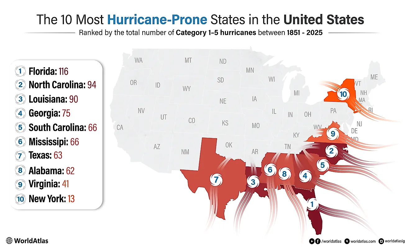
11 Best Long-Distance Hiking Trails In The US
There are two kinds of people: those who hear "walk 2,000 miles through the woods" and recoil, and those who immediately start pricing out freeze-dried lasagna. This list is for the second group, plus the first group's morbid curiosity. Long-distance hiking pulls in gap-year students, fresh retirees, and people quietly walking off a bad year, and it humbles all of them the same way. The hardest part is rarely the terrain. It is picking which absurdly long footpath to attempt first. Here are eleven of the best. The shortest is a two-week loop. The longest swallows most of a calendar year.
North Country Trail

Start with the big one. The North Country National Scenic Trail runs about 4,800 miles, which makes it the longest trail in the National Trails System and more than double the length of the better-known Appalachian Trail. It crosses eight states across the Upper Midwest and Northeast: North Dakota, Minnesota, Wisconsin, Michigan, Ohio, Pennsylvania, New York, and Vermont. Along the way it skirts three of the Great Lakes, absorbs entire other long trails like the Superior Hiking Trail and most of the Buckeye Trail, and rolls past prairies, glacial lakes, and the occasional small town. Almost nobody thru-hikes the whole thing in one push, which is less a knock on hikers than a reasonable response to 4,800 miles.
American Discovery Trail

If 4,800 miles sounded reasonable, the American Discovery Trail is here to recalibrate your sense of reasonable. It runs roughly 6,800 miles, the longest route in the country, and crosses the whole thing coast to coast: Cape Henlopen, Delaware, on the Atlantic, out to Point Reyes National Seashore near San Francisco on the Pacific. It is the only non-motorized trail that pulls off the full coast-to-coast trick. Through the middle of the country it splits into a northern arm and a southern arm, so anyone hiking it picks a side, which trims the route to either 4,834 or 5,057 miles and means no two thru-hikers quite agree on how far they went. It threads through 15 states and a grab-bag of landscapes: cornfields, desert, mountains, and city sidewalks.
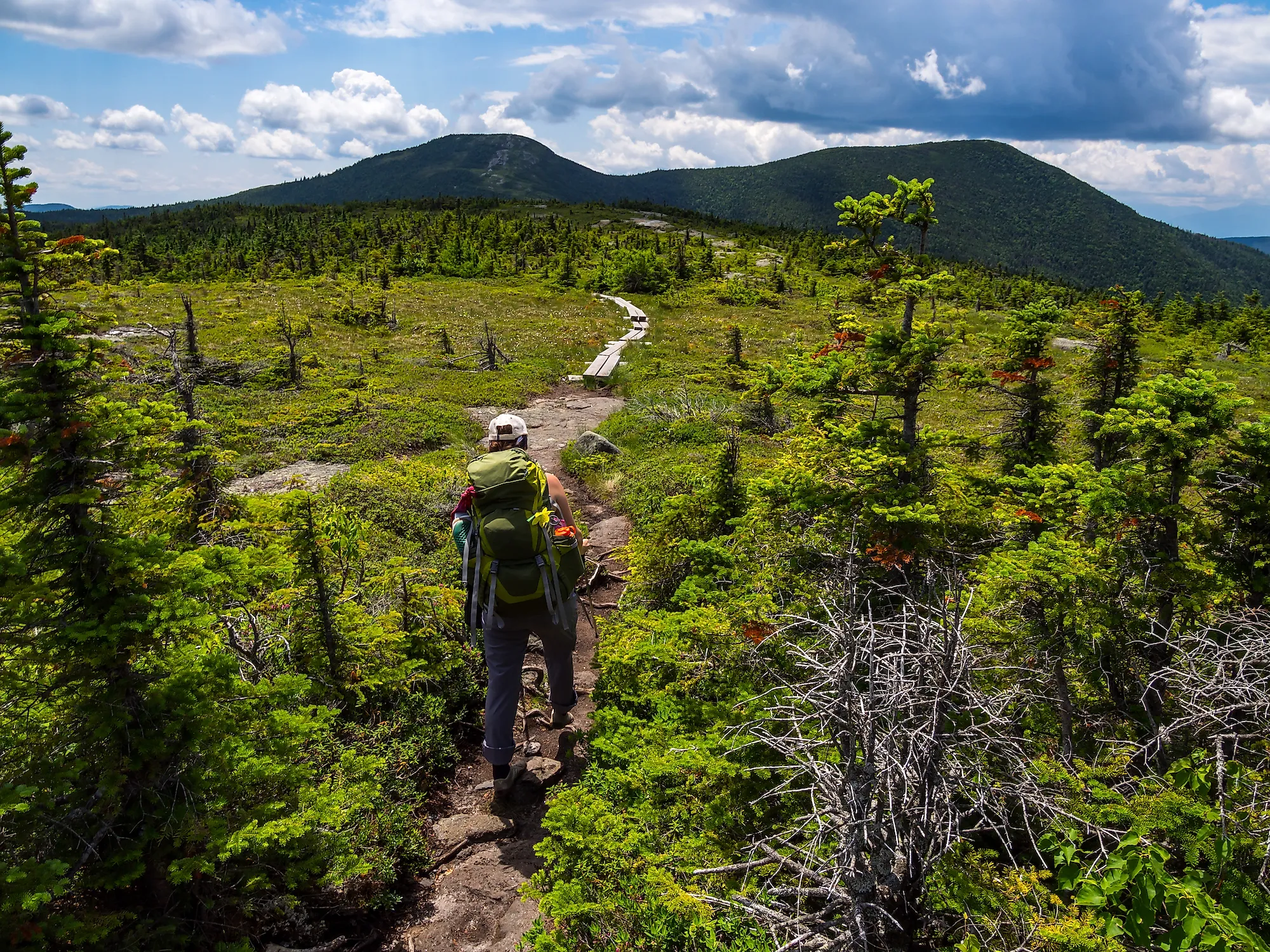
Wonderland Trail

Finally, something you could finish on a long vacation. The Wonderland Trail is a 93-mile loop that circles all the way around Mount Rainier in Washington, and it does not let you off easy: those 93 miles pack in about 22,000 feet of climbing, roughly three-quarters of an Everest, spread across the loop. Eighteen backcountry campsites let you carve the route into manageable days, which you will want, because the trail keeps throwing glaciers, wildflower meadows, and waterfalls at you while Rainier looms over Washington like it is photobombing every single view. Permits are competitive, so plan early or plan to be disappointed.
Appalachian Trail

This is the one your coworker keeps threatening to do. The Appalachian Trail runs about 2,190 miles up the spine of the eastern US, and despite the longer trails above it, the AT still holds the title of the longest hiking-only footpath in the world: no bikes, no horses, just boots. Two to three thousand people set out to thru-hike it every year, walking through 14 states between Georgia and Maine, past woods, farmland, rolling hills, sharp climbs, and a parade of trail towns with strong opinions about pie. It was finished in 1937 and has been kept alive by an army of volunteers ever since. Still not enough mileage? You can bolt on the 339-mile Pinhoti Trail south of the Georgia end and really commit.
Pacific Northwest Trail

The Pacific Northwest Trail bills itself as the wildest National Scenic Trail, and it has the resume to back it up. Over its 1,200 miles, it runs east to west between the Continental Divide and the Pacific, crossing seven mountain ranges and three national parks (Glacier, North Cascades, and Olympic), with long lonely stretches of national forest in between. Resupply and transportation are a constant headache. So are the bears: black bear habitat covers nearly the entire corridor, except for about 70 miles of Puget Sound islands, and the northern sections sit in grizzly country, so a bear canister and a little humility are non-negotiable. The trail is also still a work in progress, which is a polite way of saying you will sometimes be navigating more than walking.
Pacific Crest Trail

The Pacific Crest Trail is the one Hollywood made famous and the one people quote Cheryl Strayed about. It covers roughly 2,650 miles and takes most hikers four to six months, climbing out of the Mojave Desert, through deep forest, and up into the snowbound high passes of the Sierra Nevada and Cascades. The weather swings wildly and so do the logistics, since you are resupplying across some genuinely empty country. Pull it off and you will have walked the entire western edge of California, Oregon, and Washington, border to border, a sentence very few humans get to say with a straight face.
John Muir Trail

Want the Sierra Nevada highlight reel without quitting your job? The John Muir Trail delivers about 211 miles of the PCT's finest scenery and can be done in roughly two weeks if you keep moving. It links Yosemite Valley with the summit of Mount Whitney, which at 14,505 feet is the highest point in the lower 48, so the trail politely saves its hardest climb for the very end. It is named for the conservationist John Muir, who took one look at Yosemite and spent the rest of his life lobbying to protect it. Expect kind weather, unkind climbs, and a half-dozen high passes that will make you grateful you trained.
Continental Divide Trail

The Continental Divide Trail is the one serious hikers save for last. Running about 3,000 miles, give or take, it follows the spine of the Rocky Mountains along the Continental Divide through New Mexico, Colorado, Wyoming, Montana, and a slice of Idaho. It swallows a big chunk of the 567-mile Colorado Trail along the way. Of the national scenic trails it is the highest and most remote, which is exactly why it is the hardest: every year a few hundred hikers start, and only about a third reach the end. The other two-thirds learn something valuable about themselves, usually around 11,000 feet.
Tahoe Rim Trail and Tahoe 200

Stare at Lake Tahoe long enough and the thought creeps in: could I walk all the way around it? Good news, you can. Less-good news, it takes about ten to fifteen days and roughly 170 miles, with around 28,000 feet of total climbing. For scale, Mount Everest stands 29,032 feet, so the Tahoe Rim Trail makes you climb most of an Everest just to end up back where you started. The route mostly stays high, topping out near 10,300 feet at Relay Peak and dipping to about 6,200 feet near Tahoe City, so acclimatizing first is wise. And if a single loop of the largest alpine lake in North America feels insufficient, the Tahoe 200 ultramarathon laps it in 205 miles, with extra suffering bolted on for fun.
Florida Trail

For a long trail that trades mountains for swamp, head to Florida. The Florida National Scenic Trail covers about 1,500 miles between Big Cypress National Preserve in the south and the Gulf Islands National Seashore near Pensacola in the north, and it is the only subtropical National Scenic Trail in the country. It breaks into four regions, each with its own personality: panhandle beaches and the state's high points, plantation country and Civil War battlefields, a loop around Orlando, and a southern stretch of cattle ranches and genuine alligator-grade swamp. Time it wrong and you will hike in standing water. Time it right and you get Florida at its strangest and best.
Mountains-to-Sea Trail

Last one, and it never leaves home. The Mountains-to-Sea Trail covers about 1,175 miles entirely inside North Carolina, starting in the Great Smoky Mountains and finishing at the Outer Banks on the Atlantic. The name is the entire itinerary: you begin in misty Appalachian peaks and end with sand between your toes. About 725 miles run on blazed wilderness trail right now, with the rest stitched together using backroads, bike paths, and even an optional paddle segment, because apparently walking the width of a state was not quite enough.
So Which One Do You Pick?
Here is the honest answer: it depends on how much of your life you are willing to hand over. The Wonderland and John Muir trails fit inside a vacation. The Appalachian, Pacific Crest, and Continental Divide trails ask for half a year and a high tolerance for your own company. The American Discovery Trail asks for a full year and a streak of stubbornness that borders on concerning. None of them is the wrong choice, because every one hands you the same strange package: blisters, bug bites, a few unshakeable friendships, and the quiet realization that you are tougher than you assumed. The only real mistake is standing at the trailhead forever, trying to decide. Pick one. Start walking.