The Lowest Point In Every US State
Most travelers consider mountain peaks and other high points in America as ideal traveling destinations since it is no secret that tourists love the view of beautiful mountain ranges. However, the lower points of the U.S. should not be overlooked, as they provide equally fantastic views of some of the finest lakes in the country. Points such as the Delaware River, Potomac River, and other ocean coastlines are usually the lower regions in each state but also offer some of the loveliest scenes.
Some portions, such as Badwater Basin, are very low-lying regions, resting some 200 feet below sea level. These regions were once massive lakes, similar to how modern lakes are the lower sections of most areas of America. With 22 states sitting at sea level, there is plenty to see regardless of which state travelers choose to explore!
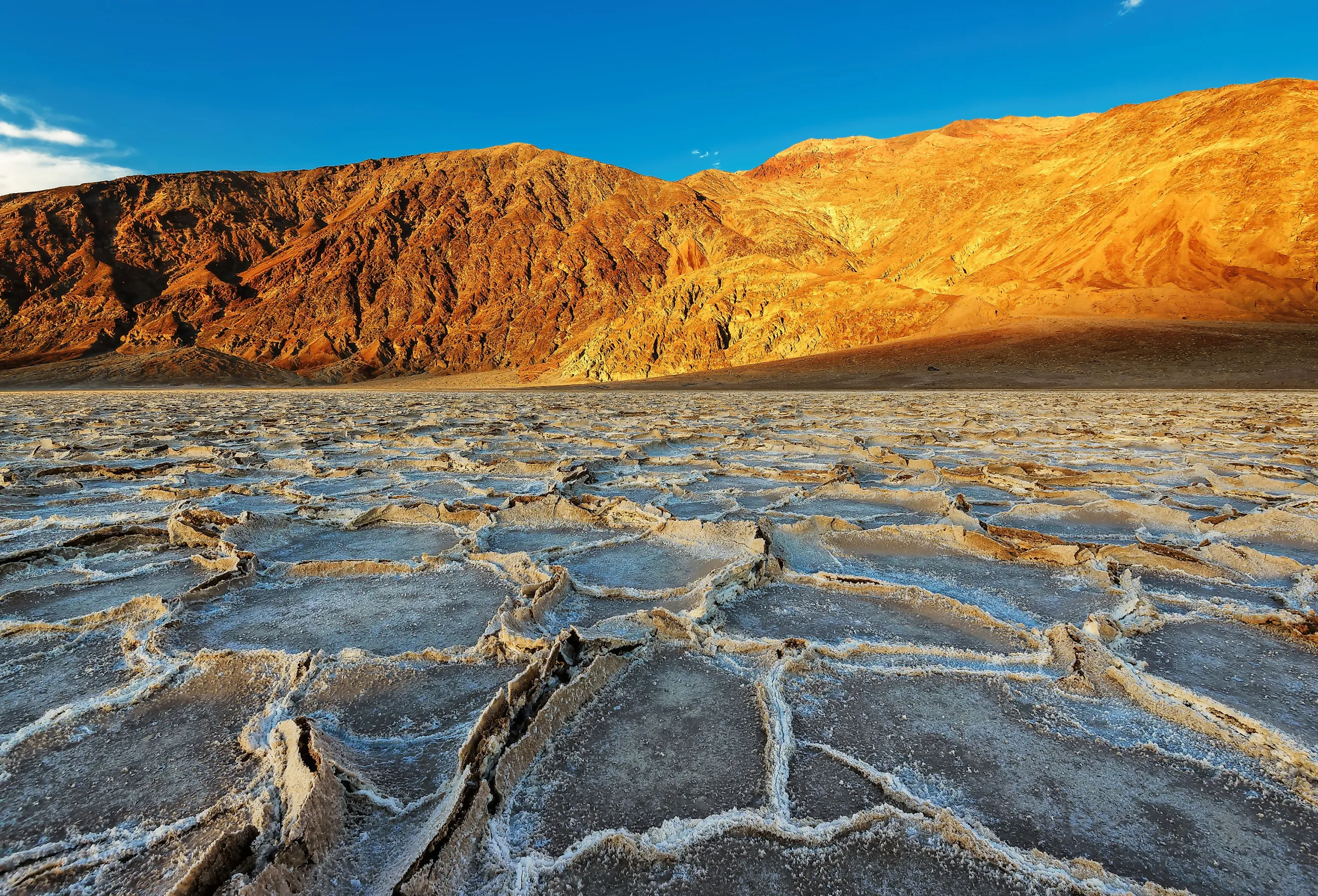
Badwater Basin, California

Badwater Basin in Death Valley National Park, California, is the lowest point in the United States. This ancient lake, known as inland Lake Manly, evaporated tens of thousands of years ago. The evaporation left behind high amounts of sodium chloride, making this region remarkably devoid of life, with white salt coating the ground.
The ancient water basin rests 282 feet (86 meters) below sea level and covers approximately 200 square miles (518 square kilometers). Aside from sodium chloride, the region also contains heavy amounts of gypsum, calcite, and borax.
Potomac River, District of Columbia (D.C.)

The Potomac River is also known as the “Nation’s River,” thanks primarily to Washington’s affinity for the location. Although this river crosses several states, including Pennsylvania and West Virginia, the portion in Washington, D.C., is among the lowest. The portion of the river flowing near the eastern border of Maryland is the lowest section, reaching merely approximately one foot above sea level (less than one meter).
New Orleans, Louisiana

New Orleans is another portion of the United States below sea level. While many states are at or just above sea level, only a few points across the United States sit below sea level. The city of New Orleans is one of the areas sitting below sea level, with the lowest point reaching 8 feet below sea level (approximately 2 meters).
Much of the region experienced subsidence in the past or the gradual depletion of land. Subsidence occurs when the earth’s surface gets pulled away by water erosion. Ocean erosion is widespread in Louisiana, with Hurricane Katrina causing considerable damage to the shore and coastal communities.
Lowest High Points of America
Among the more mountainous regions of the U.S. are different areas of low-lying lands. These usually occur near water basins or the mouths of rivers and lakes. Coastal sites along the ocean are also lower than surrounding areas, with some of the lowest points situated along portions of the Pacific and Atlantic oceans.
Delaware River, PA

The Delaware River passes through five U.S. States, including Maryland, New Jersey, Delaware, New York, and Pennsylvania. It serves as a partial natural boundary between Pennsylvania and New York and New Jersey. The mean elevation of Pennsylvania is 1,100 feet (335 meters), but the portions of the state with the Delaware River sit around sea level.
Harpers Ferry, Potomac River, WV

Most of West Virginia sits well above sea level, with most of the state situated within the Appalachian Mountains. The region by Harpers Ferry, situated near the borders of Maryland and Virginia on West Virginia’s Eastern Panhandle, is the lowest part of this mountainous state. The Potomac River is a natural boundary between the three states and is also the lowest portion of this region, sitting at an elevation of 240 feet above sea level (73 meters).
Ouachita River, Ouachita Mountains, AK

The Ouachita River flows in the southern parts of Arkansas. The portion of the river flowing between the borders of Arkansas and Louisiana is one of the lowest parts of the river. In contrast to Arkansas’s highest point, Signal Hill, which reaches 2,753 feet (839 meters), the Ouachita River sits 55 feet (17 meters) above sea level.
Kootenai Falls, Kootenai River, Montana

Kootenai Falls in southern Montana is the lowest portion of this state. Most of the state reaches high elevations thanks to the many mountains cascading throughout its borders. However, the section near Idaho’s border is significantly lower due to the Kootenai River and Falls. Despite being Montana’s lowest point, it still sits at an impressive 1820 feet (555 meters) above sea level.
Ranking of Each U.S. State
| Rank | Location | State | Elevation |
|---|---|---|---|
|
1 |
Badwater Basin |
California |
-282 feet |
|
2 |
New Orleans |
Louisianna |
-8 |
|
3 |
Gulf of Mexico |
Alabama |
Sea Level |
|
4 |
Pacific Ocean |
Alaska |
Sea Level |
|
5 |
Long Island Sound |
Connecticut |
Sea Level |
|
6 |
Atlantic Ocean |
Delaware |
Sea Level |
|
7 |
Atlantic Ocean |
Florida |
Sea Level |
|
8 |
Atlantic Ocean |
Georgia |
Sea Level |
|
9 |
Pacific Ocean |
Hawaii |
Sea Level |
|
10 |
Atlantic Ocean |
Maine |
Sea Level |
|
11 |
Atlantic Ocean |
Massachusetts |
Sea Level |
|
12 |
Atlantic Ocean |
Maryland |
Sea Level |
|
13 |
Gulf of Mexico |
Mississippi |
Sea Level |
|
14 |
Atlantic Ocean |
New Hampshire |
Sea Level |
|
15 |
Atlantic Ocean |
New Jersey |
Sea Level |
|
16 |
Atlantic Ocean |
New York |
Sea Level |
|
17 |
Atlantic Ocean |
North Carolina |
Sea Level |
|
18 |
Pacific Ocean |
Oregon |
Sea Level |
|
19 |
Delaware River |
Pennsylvania |
Sea Level |
|
20 |
Atlantic Ocean |
Rhode Island |
Sea Level |
|
21 |
Atlantic Ocean |
South Carolina |
Sea Level |
|
22 |
Gulf of Mexico |
Texas |
Sea Level |
|
23 |
Atlantic Ocean |
Virginia |
Sea Level |
|
24 |
Pacific Ocean |
Washington |
Sea Level |
|
25 |
Ouachita River |
Arkansas |
55 feet |
|
26 |
Colorado River |
Arizona |
72 feet |
|
27 |
Lake Champlain |
Vermont |
95 feet |
|
28 |
Mississippi River |
Tennesee |
178 feet |
|
29 |
Saint Francis River |
Missouri |
230 feet |
|
30 |
Potomac River |
West Virginia |
240 feet |
|
31 |
Mississippi River |
Kentucky |
257 feet |
|
32 |
Confluence of Mississippi River and Ohio River |
Illinois |
280 feet |
|
33 |
Little River |
Oklahoma |
289 feet |
|
34 |
Confluence of Wabash River and Ohio River |
Indiana |
320 feet |
|
35 |
Ohio River |
Ohio |
455 feet |
|
36 |
Confluence of Mississippi River and Des Moines River |
Iowa |
480 feet |
|
37 |
Colorado River |
Nevada |
481 feet |
|
38 |
Lake Erie |
Michigan |
571 feet |
|
39 |
Lake Michigan |
Wisconsin |
579 feet |
|
40 |
Lake Superior |
Minnesota |
601 feet |
|
41 |
Verdigris River |
Kansas |
679 feet |
|
42 |
Confluence of Snake River and Clearwater River |
Idaho |
713 feet |
|
43 |
Red River |
North Dakota |
751 feet |
|
44 |
Missouri River |
Nebraska |
840 feet |
|
45 |
Big Stone Lake |
South Dakota |
968 feet |
|
46 |
Kootenai River |
Montana |
1820 feet |
|
47 |
Beaver Dam Wash |
Utah |
2,180 feet |
|
48 |
Red Bluff Reservoir |
New Mexico |
2,844 feet |
|
49 |
Bella Fourche River |
Wyoming |
3,101 feet |
|
50 |
Arikaree River |
Colorado |
3,317 feet |
Conclusion
The U.S. is a diverse nation with many geologic features, including mountain ranges, raging rivers, and many coastal communities. These factors together make for a unique experience, regardless of which state you're traveling through. While people often think of high regions, like mountain peaks, when planning a trip, low regions also offer special features like woodlands and ocean views.
Rivers, coastlines, and lakes are typically the lowest portions of a U.S. State. For those who enjoy seeing the ocean or exploring a glacier lake, the low regions should definitely be on the list of places you ought to visit!


