10 Largest National Parks In The United States
The United States has 63 national parks. The 10 largest cover roughly 50 million acres between them, more land than the entire state of Wyoming. Eight of those 10 are in Alaska. The largest single park, Wrangell-St. Elias, is bigger than Switzerland and bigger than the next two parks on the list put together. The list below uses the combined "National Park and Preserve" totals reported by the National Park Service, which is how the agency manages and reports these units today.
1. Wrangell-St. Elias, Alaska (53,321 km² / 13.2 million acres)

Wrangell-St. Elias became a national park in December 1980 under the Alaska National Interest Lands Conservation Act. The park contains four major mountain ranges (the Wrangell, St. Elias, Chugach, and eastern Alaska Range), Mount St. Elias at 18,008 feet (the second-highest peak in the United States), and Hubbard Glacier, the longest tidewater glacier in North America. About 35 percent of the park is covered in glacial ice. The Kennecott Mines National Historic Landmark inside the park preserves a 14-story copper mill that operated from 1911 until the deposit ran out in 1938. Two dirt roads enter the park; everything beyond them is bush-plane country.
The park is also part of a four-park transboundary UNESCO World Heritage Site that combines it with Glacier Bay in the United States and Kluane and Tatshenshini-Alsek in Canada to create the largest internationally protected wilderness on Earth.
2. Gates of the Arctic, Alaska (34,287 km² / 8.5 million acres)

Gates of the Arctic is the second-largest national park and the least visited in the system. Total annual visitation is typically around 10,000 to 13,000 people, compared with more than 12 million for Great Smoky Mountains. The entire park sits north of the Arctic Circle, straddling the central Brooks Range. There are no roads into the park, no maintained trails inside it, and no campgrounds. Visitors arrive by bush plane and are required by the National Park Service to be self-reliant in case of emergency. Six federally designated Wild and Scenic Rivers run through it: the Alatna, John, Kobuk, Noatak, North Fork Koyukuk, and Tinayguk.
3. Denali, Alaska (24,585 km² / 6.1 million acres)

The park was originally established in 1917 as Mount McKinley National Park and renamed Denali National Park and Preserve in 1980. The mountain at its center is the tallest in North America at 20,310 feet (6,190 meters). The federal name of the peak has flipped twice in a decade: the Obama administration officially changed "Mount McKinley" to "Denali" in August 2015, and President Trump's Executive Order 14172 restored "Mount McKinley" on January 23, 2025. The state of Alaska has recognized "Denali" since 1975 and continues to do so. The park itself remains Denali National Park and Preserve.
Only one road runs into the park. The 92-mile Denali Park Road has been closed at mile 43 since 2021 because of the Pretty Rocks Landslide, a slow-moving slump on the southern slope of Polychrome Pass. Reconstruction of a bridge across the slide area is currently scheduled for completion in summer 2026. Cloud cover hides the peak roughly 70 percent of the time, so only about three in 10 visitors actually see it.
4. Katmai, Alaska (16,564 km² / 4.1 million acres)

Katmai was created in 1918 as a national monument to protect the aftermath of the 1912 Novarupta eruption, the most powerful volcanic eruption of the 20th century, which ejected roughly 30 times the volume of magma produced by Mount St. Helens in 1980. It became a national park in 1980. The Valley of Ten Thousand Smokes inside the park is a 40-square-mile ash flow from that eruption, named for the steam vents that once rose from it. Katmai now protects about 2,200 brown bears, the densest concentration in North America, which gather at Brooks Falls each July to catch sockeye salmon as the fish leap upstream. The annual Fat Bear Week tournament, run by the park since 2014, has turned individual Katmai bears into international celebrities.
5. Lake Clark, Alaska (16,309 km² / 4 million acres)

Lake Clark sits across Cook Inlet from Anchorage and has no road connection to anywhere. Visitors fly in by floatplane or take a boat across the inlet. The park protects two active stratovolcanoes (Mount Redoubt and Mount Iliamna, both part of the Pacific Ring of Fire), the headwaters of the Bristol Bay sockeye salmon fishery, and the 50-mile-long Lake Clark itself, which is the sixth-largest lake in Alaska. The park is best known publicly for Richard Proenneke, the carpenter and naturalist who built a cabin at Twin Lakes in 1968 and lived alone there for nearly 30 years. His cabin is preserved as a National Historic Site within the park.
6. Death Valley, California and Nevada (13,793 km² / 3.4 million acres)

Death Valley is the largest national park outside Alaska and the hottest, driest, and lowest place in North America. The official world-record high air temperature of 134 degrees Fahrenheit (56.7°C) was recorded at Furnace Creek on July 10, 1913, a measurement that climatologists still debate but that no other site has officially beaten in more than a century. Badwater Basin, at 282 feet below sea level, is the lowest point on the continent. Just 85 miles to the west, Mount Whitney in the Sierra Nevada rises to 14,505 feet, the highest peak in the contiguous 48 states, which makes the high-low spread between them the steepest in North America. The park became a national monument in 1933 and was upgraded to a national park in 1994 under the California Desert Protection Act, which added 1.3 million acres in the process. It is also a UNESCO Biosphere Reserve.
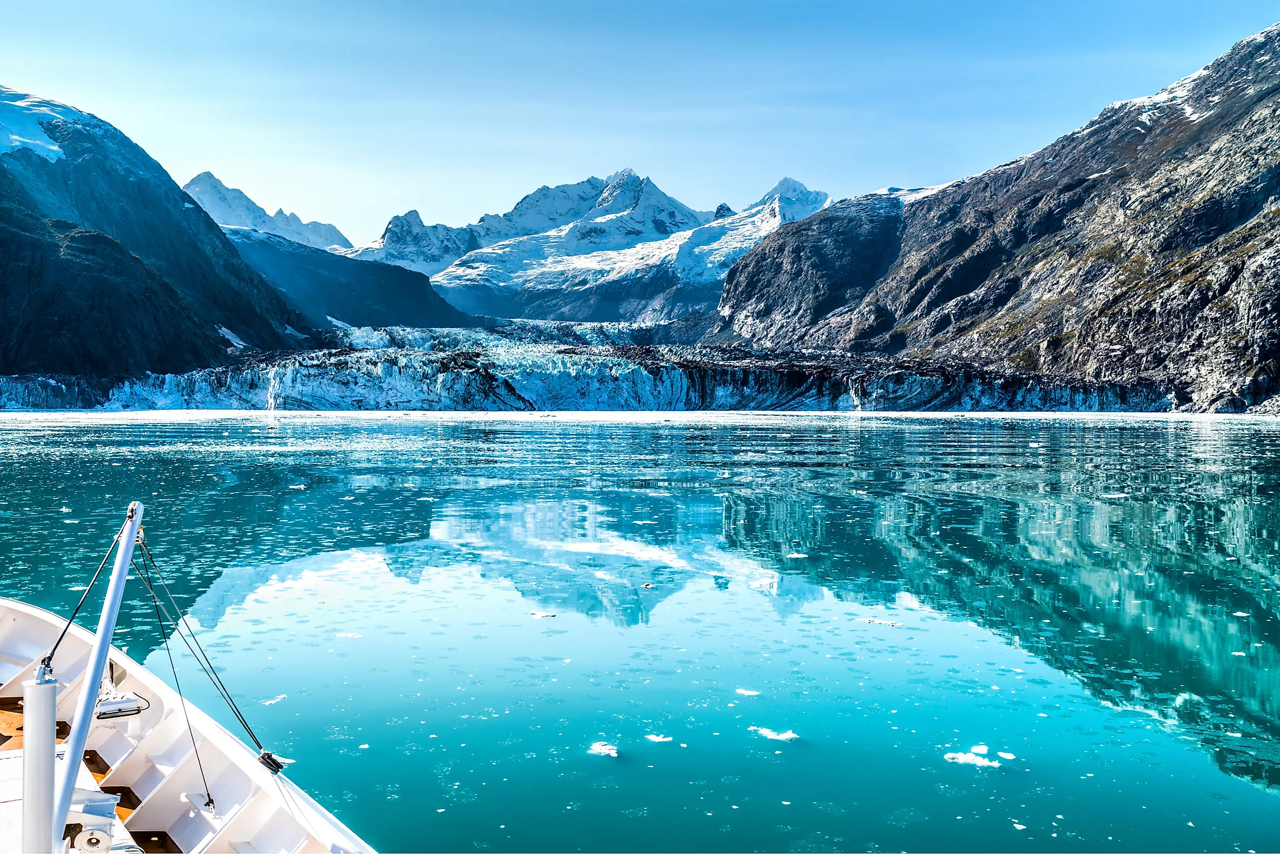
7. Glacier Bay, Alaska (13,281 km² / 3.3 million acres)

Glacier Bay protects more than 1,000 glaciers and one of the fastest cases of glacial retreat ever documented. When Captain George Vancouver charted southeast Alaska in 1794, Glacier Bay itself did not exist; what is now a 65-mile-long fjord was buried under an ice sheet thousands of feet thick. By 1879 the naturalist John Muir found that the ice had already retreated about 48 miles up the bay. Today the retreat has uncovered roughly 100 miles of new coastline, giving scientists one of the world's best-studied records of glacial succession. The park was a national monument from 1925 until 1980, when it was redesignated as a national park, and it is a UNESCO World Heritage Site as part of the Kluane-Wrangell-Tatshenshini transboundary protected area.
8. Yellowstone, Wyoming, Montana, and Idaho (8,983 km² / 2.2 million acres)

President Ulysses S. Grant signed the Yellowstone National Park Protection Act on March 1, 1872, creating the first national park anywhere in the world. The park covers about 8,983 square kilometers across three states, sitting on top of the Yellowstone Caldera, a supervolcano roughly 30 by 45 miles across that last erupted 640,000 years ago. About 500 of the world's roughly 1,000 active geysers are inside the park, including Old Faithful, which has erupted every 60 to 110 minutes on average since records began in 1872. Wildlife includes the largest free-roaming bison herd in the country (roughly 5,000 animals), reintroduced gray wolves (~100 since their 1995 reintroduction), and the largest population of grizzly bears in the contiguous United States.
9. Kobuk Valley, Alaska (7,085 km² / 1.75 million acres)

Kobuk Valley is one of two national parks (with American Samoa) that have no roads, no campgrounds, and no maintained trails of any kind. Visitors arrive by chartered bush plane from Kotzebue or Bettles. The park's signature feature is the Great Kobuk Sand Dunes, a 25-square-mile field of active dunes that formed from glacial outwash at the end of the last ice age and reach heights of about 100 feet. The Western Arctic Caribou Herd uses the park as a migration corridor. The herd is currently estimated at about 121,000 animals as of the December 2025 census, down from a peak of 490,000 in 2003. The decline is part of a broader pattern across Arctic herds that scientists have linked to warmer summers, shrubification of the tundra, and changes in snow conditions.
10. Everglades, Florida (6,107 km² / 1.5 million acres)

The Everglades is the largest tropical wilderness in the United States and the only national park where alligators and crocodiles coexist in the same waters. President Harry Truman dedicated it in 1947. The park protects only about 25 percent of the historic Everglades wetland, which once stretched roughly 4,000 square miles south of Lake Okeechobee; the rest was drained for agriculture and development through the 20th century. About 73 threatened or endangered species live inside the park, including the Florida panther (only about 230 left in the wild), the West Indian manatee, and the American crocodile. The Everglades is a UNESCO World Heritage Site and Biosphere Reserve, and it has been on the UNESCO List of World Heritage in Danger almost continuously since 1993 because of water-flow disruption from upstream agriculture and from sea-level rise.
How the System Got Here
The first piece of US federal legislation protecting public land was the Hot Springs Reservation Act, signed by President Andrew Jackson on April 20, 1832, which set aside the thermal springs at what is now Hot Springs, Arkansas. The "national park" concept came 40 years later. Yellowstone was the first, signed into existence by President Ulysses S. Grant on March 1, 1872. Mackinac Island in Michigan became the second in 1875 but was transferred to the state of Michigan and delisted in 1895. Sequoia and Yosemite both became national parks on the same day, September 25 and October 1, 1890. The National Park Service itself was not created until August 25, 1916, when President Woodrow Wilson signed the Organic Act and put the system under a single federal agency. The Service now manages 433 separate units, of which 63 carry the "national park" designation.
The 30 Largest, Ranked
| Rank | Park | State(s) | Area (km²) |
|---|---|---|---|
| 1 | Wrangell-St. Elias | Alaska | 53,321 |
| 2 | Gates of the Arctic | Alaska | 34,287 |
| 3 | Denali | Alaska | 24,585 |
| 4 | Katmai | Alaska | 16,564 |
| 5 | Lake Clark | Alaska | 16,309 |
| 6 | Death Valley | California, Nevada | 13,793 |
| 7 | Glacier Bay | Alaska | 13,281 |
| 8 | Yellowstone | Wyoming, Montana, Idaho | 8,983 |
| 9 | Kobuk Valley | Alaska | 7,085 |
| 10 | Everglades | Florida | 6,107 |
| 11 | Grand Canyon | Arizona | 4,926 |
| 12 | Glacier | Montana | 4,100 |
| 13 | Olympic | Washington | 3,734 |
| 14 | Big Bend | Texas | 3,242 |
| 15 | Joshua Tree | California | 3,218 |
| 16 | Yosemite | California | 3,083 |
| 17 | Kenai Fjords | Alaska | 2,710 |
| 18 | Isle Royale | Michigan | 2,314 |
| 19 | Great Smoky Mountains | North Carolina, Tennessee | 2,114 |
| 20 | North Cascades | Washington | 2,043 |
| 21 | Kings Canyon | California | 1,869 |
| 22 | Sequoia | California | 1,635 |
| 23 | Canyonlands | Utah | 1,366 |
| 24 | Hawaiʻi Volcanoes | Hawaii | 1,318 |
| 25 | Grand Teton | Wyoming | 1,255 |
| 26 | Rocky Mountain | Colorado | 1,076 |
| 27 | Channel Islands | California | 1,010 |
| 28 | Badlands | South Dakota | 982 |
| 29 | Capitol Reef | Utah | 979 |
| 30 | Mount Rainier | Washington | 957 |