10 Best Lakeside Towns in South Dakota
South Dakota holds water in two very different ways. In the east, glaciers carved hundreds of natural lakes into the prairie pothole region, leaving a chain of fishing holes that locals have built their summers around for generations. Down the middle of the state, the Missouri River was dammed in the mid-20th century to form four enormous reservoirs. The 10 towns below each sit on or beside these waters. Each gives travelers a pleasant downtown to explore and a public shoreline to enjoy.
Watertown

The fifth-largest city in South Dakota with a population of 22,655 at the 2020 census, Watertown sits between two glacial lakes. Lake Kampeska sits to the northwest and Pelican Lake to the southwest, with the Big Sioux River running through the middle of town. Lake Kampeska covers roughly 5,250 acres and offers six public boat ramps, plus Sandy Shore Recreation Area, Memorial Park, and Stokes-Thomas Lake City Park. The city was founded in 1879 as a Chicago & North Western Railroad terminus and named for Watertown, New York, the hometown of two of its founders.
Beyond the water, the Redlin Art Center holds more than 150 original oil paintings by wildlife artist Terry Redlin, who donated the 52,000-square-foot facility to his hometown when it opened in 1997. The Bramble Park Zoo houses over 500 animals plus a Discovery Center, and the restored Goss Opera House anchors the uptown dining and entertainment scene. Each year on the third weekend in July, Cookin' on Kampeska takes over Stokes-Thomas Lake City Park with live music and competitions for barbecue and chislic.
Pierre

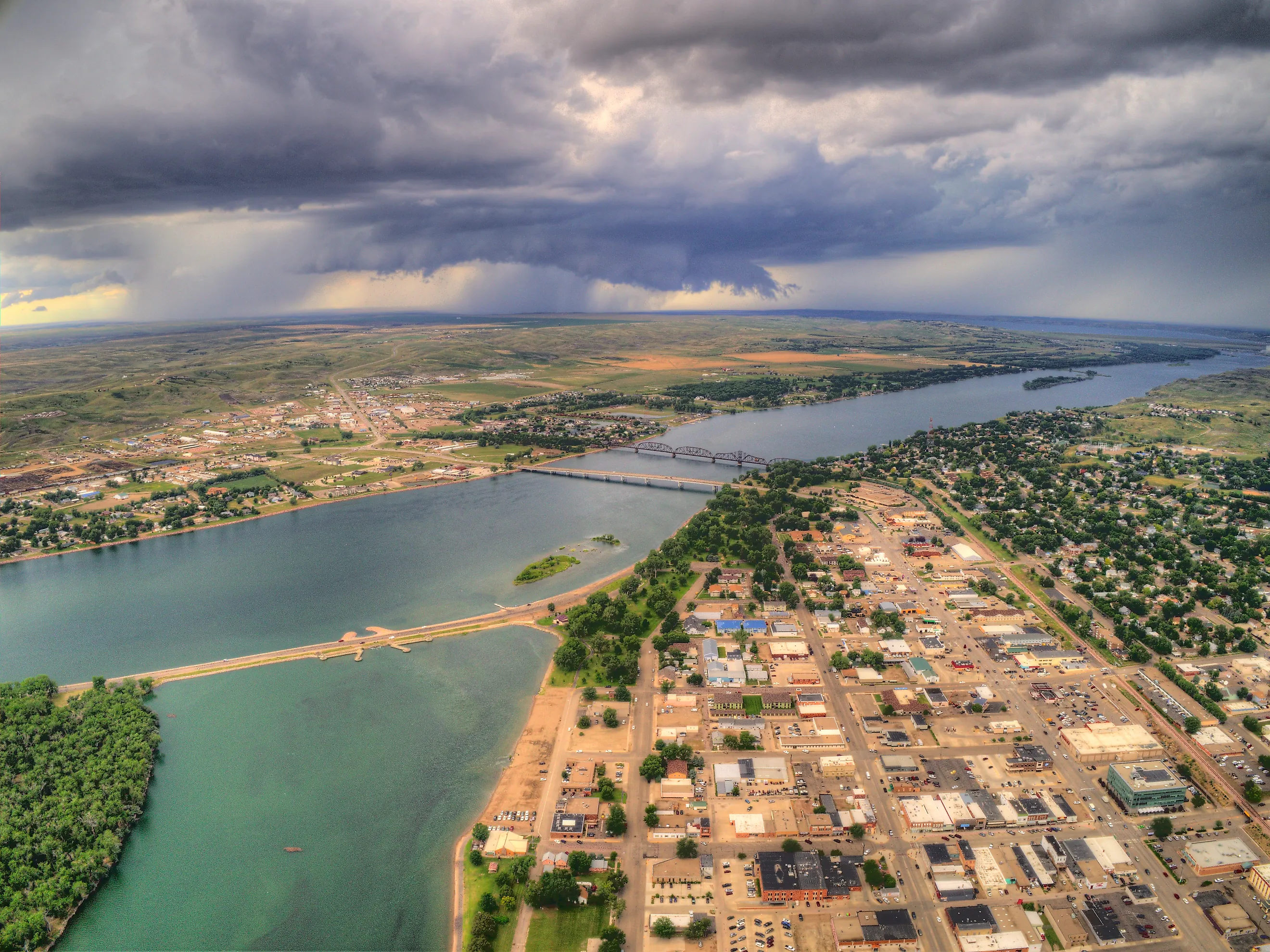
South Dakota's capital, Pierre, sits on the east bank of the Missouri River in the geographic center of the state, and with a 2020 population of 14,091 it ranks as the second-smallest US state capital after Montpelier, Vermont. Lake Sharpe stretches downstream from town, and Lake Oahe begins roughly six miles to the north at Oahe Dam. The 231-mile reservoir runs all the way to Bismarck, North Dakota. Lake Oahe alone covers about 370,000 acres with 2,250 miles of shoreline, making it the fourth-largest reservoir in the country, and its waters draw walleye, northern pike, and Chinook salmon anglers from across the Midwest. The dam itself is among the world's largest rolled-earth dams and was dedicated by President John F. Kennedy in August 1962.
Pierre's waterfront has been developed into a string of parks, and LaFramboise Island Nature Area sits a short walk from downtown with trails through cottonwood forest. A few miles east on Lake Sharpe, Farm Island State Recreation Area adds another eight miles of trails plus boat ramps and swimming. The South Dakota State Capitol, built between 1905 and 1910, anchors a 115-acre complex that also includes the Cultural Heritage Center (the headquarters of the State Historical Society, opened in 1989) and the Flaming Fountain veterans' memorial. Downtown, the South Dakota Discovery Center & Aquarium offers hands-on science exhibits for families, and Pierre Regional Airport runs daily flights to Denver.
Chamberlain

Where Interstate 90 crosses the Missouri River, the water widens into Lake Francis Case, and Chamberlain (population 2,473) sits on the east bank as the Brule County seat. The reservoir is the 11th-largest in the country, running 107 miles south to Fort Randall Dam and covering about 102,000 acres, with some of the strongest walleye spawning habitat anywhere on the Missouri River system. Many cross-country travelers stop in town whether they planned to or not, and the local economy runs on river tourism, pheasant hunting, and the steady stream of I-90 traffic.
The town's signature landmark is Dignity: Of Earth & Sky, a 50-foot stainless steel sculpture by South Dakota artist Dale Lamphere that overlooks the river from a bluff just off the interstate. The piece depicts a Lakota woman draped in a star quilt made of 128 stainless steel blue diamonds that flutter with the wind, and it was gifted to the state by Rapid City entrepreneurs Norm and Eunabel McKie in 2016. Travelers can pair it with the Akta Lakota Museum & Cultural Center at St. Joseph's Indian School, which preserves Lakota and Dakota artifacts, and the South Dakota Hall of Fame, which honors more than 800 notable South Dakotans, including broadcaster Tom Brokaw.
Mobridge

Mobridge sits on the east bank of Lake Oahe at the reservoir's northern end and serves as the Walworth County seat, with a population of 3,261 at the 2020 census. The town was founded in 1906 when the Chicago, Milwaukee, St. Paul & Pacific Railroad pushed a bridge across the Missouri River. Telegraph operators abbreviated the crossing as "MO Bridge," and the name stuck. The town has built its identity around walleye. The lake regularly produces fish over 10 pounds during the spring-through-fall season, nationally ranked tournaments bring competitors from across the country, and ice fishing keeps the action going through February.
Mobridge's cultural draws lean heavily on its proximity to the Standing Rock and Cheyenne River Sioux reservations. Inside the Scherr-Howe Event Center downtown, 10 large-scale Indian murals painted by Yanktonai Dakota artist Oscar Howe in 1941 and 1942 cover the auditorium walls. A few miles outside town, a granite-pedestaled bust honors Chief Sitting Bull on a bluff above the Missouri, with a companion monument to Sacagawea nearby (the Sitting Bull burial claim is disputed, but the site itself is striking). Round things out at the Klein Museum, where the collections range from Native American beadwork and agricultural history to a populous cast of Wild West mannequins.
Yankton

Yankton was the first capital of Dakota Territory and still answers to "Mother City of the Dakotas." The town sits on the Missouri River just downstream of Gavins Point Dam, which impounds Lewis and Clark Lake, a 25-mile-long, 31,400-acre reservoir with more than 90 miles of shoreline that begins about four miles west of town. With a 2020 population of 15,411, Yankton is the seventh-largest city in the state. Lewis and Clark Recreation Area, on the lake's northern shore, ranks as the state's second-most-visited state park (after Custer State Park) and offers more than 400 campsites, swimming beaches, hiking and biking trails, and a full-service marina and resort.
Downtown, the decommissioned double-decker Meridian Bridge has been converted to a pedestrian and bike crossing over the Missouri. The US National Park Service headquarters for the Missouri National Recreational River is also located in town, and the 59-mile stretch of free-flowing river immediately downstream of Gavins Point Dam is one of the few remaining unchanneled sections of the Missouri. Mount Marty University, a private Catholic school founded by the Benedictine Sisters of Sacred Heart Monastery, adds a small college-town element to the dining and arts scene. More than 10 miles of paved trail link the recreation area to downtown, which means most of the city's water access is reachable on foot or by bike.
Madison

About 30 miles northwest of Sioux Falls in central Lake County, Madison (population 6,191 at the 2020 census) sits between two glacial lakes, Lake Herman to the west and Lake Madison to the southeast. The town was founded in 1880 when the earlier settlements of Herman and Lake Madison merged.
Lake Herman covers roughly 1,350 acres and is the centerpiece of Lake Herman State Park, where the campground sits on a peninsula amid native oak and prairie grass. The Herman Luce Cabin, built in 1871 and added to the National Register in 1977, still stands inside the park. Lake Madison is the larger of the two at about 2,800 acres, with Walker's Point Recreation Area on its eastern shore offering camping, fishing, and a boat launch.
Two miles west on Highway 34, Prairie Village is an open-air history museum with more than 40 restored buildings, agricultural displays, a steam carousel, and an operating railroad that runs Saturday afternoon train rides. Madison is also home to Dakota State University, which has built a national reputation in cybersecurity.
Big Stone City

Tiny Big Stone City (population 412 at the 2020 census) anchors the far northeastern corner of Grant County at the southern tip of Big Stone Lake. The lake runs 26 miles along the Minnesota-South Dakota border, covers 12,610 acres, and at 962 feet of elevation marks the lowest point in South Dakota. It's also the source of the Minnesota River, which flows 332 miles before joining the Mississippi. Big Stone Lake was carved by glacial meltwater at the end of the last ice age, when Glacial Lake Agassiz drained through what became the Glacial River Warren valley.
The town was established in 1878 and incorporated in 1885, and the area still trades on its fishing reputation. The lake holds more than 30 species and gets stocked with 7 million walleye fry every two years. Hartford Beach State Park, on the South Dakota shore north of town, contains American Indian burial mounds and a prehistoric village site, along with five hiking trails through wooded bluffs. Big Stone City sits directly across the state line from Ortonville, Minnesota, and the two towns share an annual walleye tournament.
Pickstown

Pickstown exists because of a dam. The town was built in the late 1940s as a government settlement housing US Army Corps of Engineers workers constructing Fort Randall Dam, which broke ground in 1946 and impounded Lake Francis Case. At peak construction, Pickstown housed close to 5,000 people. Today, the 2020 census puts the population at 230. The Corps owned the town outright until residents voted to incorporate in 1985.
Named for Lieutenant Gen. Lewis A. Pick, former director of the Corps' Missouri River office, Pickstown sits at the south end of Lake Francis Case in Charles Mix County and gives travelers an unusually concentrated dose of mid-century engineering, western frontier history, and Missouri River recreation.
The Fort Randall Dam Visitor Center looks out over the dam, the reservoir, and the river below, with exhibits on construction and paleontology plus a freshwater aquarium of native fish. Just southwest of the dam are the ruins of the Fort Randall Military Post (1856-1892), where Chief Sitting Bull was incarcerated from 1881 to 1883. The Karl E. Mundt National Wildlife Refuge, immediately downstream, serves as a wintering sanctuary for bald eagles. Tom Brokaw spent his early childhood in Pickstown when his father worked on the dam, before the family settled in Yankton.
Lake Preston

A small Kingsbury County town of about 590 people, Lake Preston has a notable bit of recreational history: residents say it's home to the first large outdoor swimming pool in South Dakota, and the local high school athletic teams are called the Divers. The town was named for the lake it sits beside. Lake Henry and Lake Whitewood lie nearby as well.
About six miles southwest on US Highway 14 is Lake Thompson Recreation Area, centered on the 16,236-acre Lake Thompson, one of the largest natural lakes in the state and a designated National Natural Landmark. That last designation gets more remarkable when you learn the lake was completely dry pasture in the 1930s, only refilling after heavy rains in the mid-1980s. Today the recreation area has 97 electric campsites, five cabins, a group lodge, and more than 2.5 miles of trail through tallgrass prairie. Each June, the Lake Preston Chamber hosts its Lake Thompson Fishing Tournament, now in its 37th year.
Waubay

Waubay takes its name from a Sioux word meaning "place of nesting birds," which proves apt: just north of town, the Waubay National Wildlife Refuge covers 4,650 acres of lakes, marshes, grasslands, and woodlands, and 245 bird species have been recorded on the refuge across the seasons. Day County, where Waubay sits, contains more natural lakes than any other county in South Dakota, and the town (population 472) makes a logical base for fishing the Waubay Chain, a 10-lake interconnected system that includes Bitter, Blue Dog, Enemy Swim, and Pickerel lakes plus Waubay Lake itself.
Waubay Lake has expanded dramatically in recent decades thanks to rising water tables in the prairie pothole region. It now covers more than 15,000 surface acres. Bitter Lake, just east of town, is a closed-basin lake. It produces some of the strongest walleye and perch fishing in the Midwest. Bitter Lake Lodge & Campground sits on the lake's northeastern shore with a private boat launch, restaurant, and seasonal campsites. Guided fishing services run out of nearby Webster for travelers who'd rather have a local pick the spots.
South Dakota's Most Memorable Lakeside Getaways
South Dakota's lake towns cluster naturally along two corridors. Watertown, Madison, Lake Preston, Waubay, and Big Stone City form a northeast loop through the glacial lakes, all within a couple of hours of Sioux Falls. Pierre, Chamberlain, Mobridge, Pickstown, and Yankton trace the Missouri River through the state's center and sit along the Native American National & State Scenic Byway. Most of these towns peak between Memorial Day and Labor Day, but ice fishing, eagle viewing, and pheasant hunting keep them on the map well into winter.