The Northernmost Town in the Lower 48
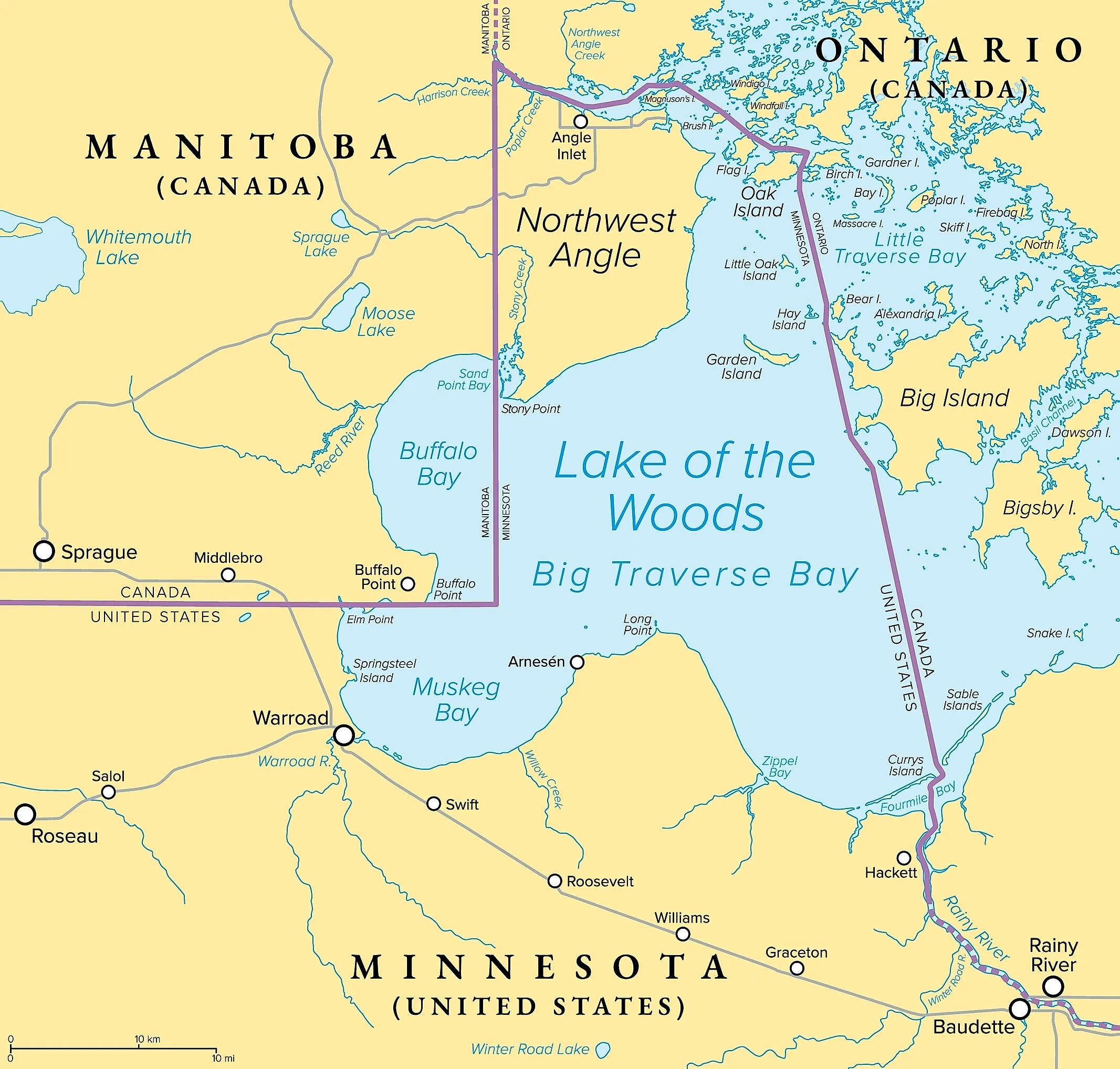
This tiny and remote community is located in the Northwest Angle, a part of the state of Minnesota on Lake of the Woods. It is geographically unique and significant, as Angle Inlet is located within the northernmost point of the contiguous United States. The Northwest Angle is, due to a mapping error in the late 18th century, cut off from the rest of Minnesota by the Lake of the Woods, and it cannot be reached by car without crossing into the Canadian province of Manitoba, and there is also a maritime border with Ontario. Angle Inlet's position north of the 49th parallel, the primary continuous border between the United States and Canada, makes it the farthest north regularly inhabited area in the Lower 48. Angle Inlet, population 54 according to the 2020 United States Census, is home to the northernmost US Post Office in the contiguous United States, and also has the last operating single-room public schoolhouse in Minnesota. The local economy is based around remote wilderness tourism and ice fishing on Lake of the Woods, and is renowned for its walleye fishing.
The Northwest Angle

The Northwest Angle is a heavily forested peninsula, part of Lake of the Woods County. It is roughly 120 square miles (310 square km) and is known for being the only part of the contiguous United States located north of the 49th parallel, as well as the northernmost point. One of the few non-island exclaves in the United States, the Northwest Angle is surrounded by Manitoba on the land, and separated from Minnesota by the Lake of the Woods. This geographic anomaly was due to a mapping error created by the 1783 Treaty of Paris, which formally ended the American Revolution and drew the boundaries between the new United States of America and the British colonies that are now Canada. The treaty used an inaccurate 1755 map, and the negotiators believed the Mississippi River originated further northwest than it actually did. They drew a border line to connect the lake's most northwestern point directly to the river. The problem was not resolved until 1818. The London Convention, or the Treaty of 1818, was an agreement between the United States and the United Kingdom that settled boundary disputes remaining after the War of 1812. The boundary was resolved by running a line due south from the lake's northwesternmost point until it reached the 49th parallel, then west along it, which retained the Northwest Angle as US territory and officially made it a pene-exclave.
What is a Pene-Exclave?
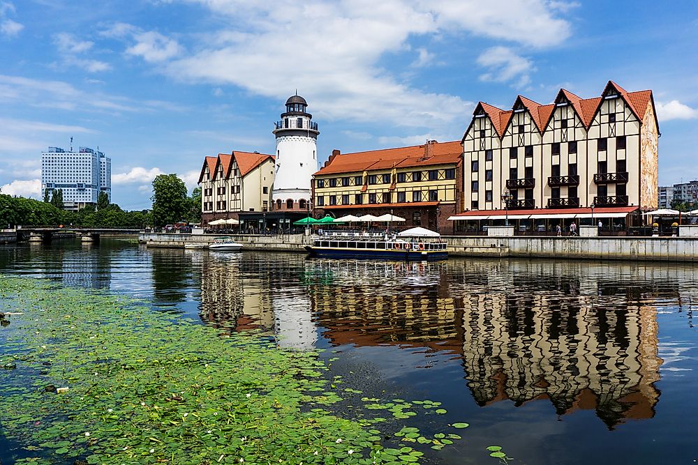
An exclave is a part of one country that is separated from its main territory. This is comparable to an enclave, where one independent nation is surrounded by another. An example of an exclave is Kaliningrad, a Russian region on the Baltic Sea, surrounded on land by Poland and Lithuania with no land connection to Russia. Lesotho, on the other hand, is an enclave, as the entire nation is surrounded by a different nation, in this case, South Africa. A pene-exclave, or quasi-exclave, is a territory that is part of the mainland of the country it is part of, but cannot be reached by land from the home country. It is different from an exclave proper because it is not surrounded by foreign land. The territory is surrounded by a foreign nation in addition to a natural barrier, such as a body of water. The Northwest Angle is an example of a pene-exclave, as it is part of Minnesota, a state within the United States, cut off by land from the rest of the contiguous United States by the Lake of the Woods and Canada. Point Roberts, Washington is also a noted pene-exclave. A part of the United States, it is attached to Canada at the southern tip of the Tsawwassen peninsula, and can only be reached by land through Canada, with water separating it from the rest of the United States.
Geographic Extremes

Angle Inlet is the northernmost town in the contiguous United States. However, if one looks at the full United States, all 50 states without including US territories, the geographic extremes are very different. In the same way that Angle Inlet is the northernmost town in the contiguous United States, Key West, Florida, is the southernmost city of the contiguous United States. An island, Key West is connected to mainland Florida by the Overseas Highway. As a territory of the state of Florida, even as an island, it remains the furthest south, only 90 miles from Cuba, and marked by a concrete buoy marked with Southernmost Point. However, if we include all 50 states, the two extremes change. The northernmost town in all 50 states is Utqiaġvik, Alaska, located at 71°17′N latitude, above the Arctic Circle on the Chukchi Sea. With a population of 4,927, according to the 2020 US Census, Utqiaġvik is not accessible by car and can only be reached by flight or small boats. On the other extreme is Nāʻālehu, Hawaii, at 19°03′N latitude on the Big Island of Hawaii. A plantation town, Nāʻālehu is the southernmost town of all 50 states. With a population of 1,007 people according to the 2020 US Census, Nāʻālehu sits just north of Ka Lae, the southernmost point of all 50 states.
Getting There

To reach the Northwest Angle and Angle Inlet by car, travelers need to travel north on Minnesota State Highway 313 through the Warroad-Sprague Border Crossing. At the border, there is a staffed Canada Border Services Agency checkpoint. US visitors need a valid US passport, NEXUS Card, or Enhanced Driver's License. There are strict entry laws in Canada, and those with felonies or DUI offenses on their record are criminally inadmissible and will be turned away without special prior rehabilitation waivers. Over the border into Manitoba, drivers take Highway 12 to Provincial Road 308, then connect to Provincial Road 525. The Canadian part of the drive is around 50 miles, with the last 20 miles being remote gravel roads. On returning to the US, there is a kiosk system that is unstaffed. There is no physical checkpoint or gate, and US residents returning to the United States are required to immediately report their arrival to US Customs and Border Protection. This is done using a video-phone kiosk located at Jim's Corner, a small roadside shed.
If boating, crossing the unmarked water border still falls under strict customs laws, conservation regulations, and bait restrictions. However, if you cross the border on the lake for pleasure fishing and remain in your boat, you generally do not have to report to customs. Boaters are required to remain in the boat, cannot drop anchor, tie up to a dock, touch land, or make physical contact with another vessel in Canadian waters. There are strict ecological protections to prevent the spread of aquatic invasive species, and boaters are not permitted to bring live, dead, or frozen bait of any kind, such as minnows, nightcrawlers, leeches, or frozen baitfish, into Canadian waters. Anglers are required to use barbless hooks only, and open alcohol on a boat specifically in Ontario waters is prohibited. It is possible to travel to the Northwest Angle by boat through US waters only, and in the winter, ice road access is possible as well.
A Small but Significant Town
Geographic anomalies and extremes are as interesting as they are difficult to definitively confirm as significant examples of an anomaly. What counts as "most northern" is up for debate. Angle Inlet is not the northernmost inhabited community in the whole of the United States, but due to its geographically significant location north of the 49th Parallel, it is remote and isolated. It is still more accessible to Americans than Utqiaġvik, Alaska. As the northernmost town in the Lower 48, Angle Inlet carries a significance and unique position in American geography and history, far greater than its size.