9 Most Scenic Drives In Alberta
Alberta's vast and diverse array of landscapes, from flat prairie grasslands to lofty mountain ranges and almost endless expanses of forests, is most easily explored on the road. Whether you aim to see the badlands around Drumheller, the dramatic alpine scenery of Banff, or a maybe lesser-known corner of the province, we will be covering 9 routes that you ought to travel at least once to get a full picture of the region. Read on to get the inside scoop on these must-do drives, from the optimum times of year to go to the best roadside stops along the way.
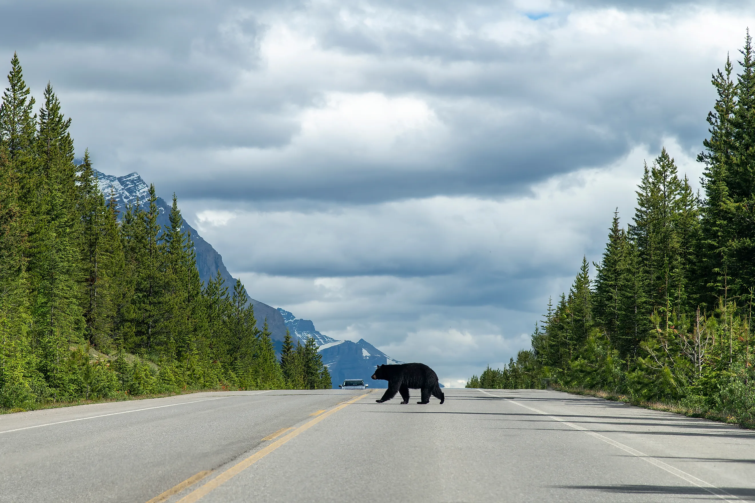
Icefields Parkway

Stretching 232 kilometers between Lake Louise and Jasper, the Icefields Parkway (Highway 93) is perhaps Alberta’s most famous mountain corridor. The route cuts through both Banff National Park and Jasper National Park, with plenty of viewpoints facing expansive glaciers, towering valleys, and snowcapped peaks.
Key stops on the way include Peyto Lake, Mistaya Canyon, and the Columbia Icefield, the latter of which features a number of trails that lead to the Athabasca Glacier as well as a visitor center where you can embark on an "Ice Explorer" bus tour directly on top of the glacier. Wildlife, like elk, bighorn sheep, and occasionally bears, are also common along the shoulders, particularly at dawn and dusk.
The Parkway is open year-round, though winter conditions require snow tires and attention to avalanche advisories. Allow at least three hours without stops, although we recommend most drivers take a full day to soak it all in. Also note that fuel stops are limited to a handful of spots, namely the hamlet of Lake Louise, Saskatchewan River Crossing, and downtown Jasper, so plan accordingly.
David Thompson Highway

Running west from Red Deer to the junction with Icefields Parkway near Saskatchewan River Crossing, the David Thompson Highway (Highway 11) is a quieter alternative to some of Alberta’s busier mountain routes. The most scenic stretch begins west of Rocky Mountain House, where rolling foothills give way to the sharp limestone ridges and open river valleys of the mighty Rocky Mountains.
Specific highlights include Abraham Lake, known for its deep turquoise color in the summer and methane bubbles frozen beneath the ice in the winter, and Crescent Falls, a short walk from the highway. Keep an eye out for wild horses, too, which frequently roam around this part of the province.
As mentioned, traffic here is generally light, but services also thin out considerably west of Rocky Mountain House. Fuel up early and check conditions in winter, when wind can create drifting snow across exposed sections. However, the route is fully paved and suitable for standard vehicles, with numerous other informal pullouts for photographs, campgrounds, and trailheads, especially in and around the town of Nordegg and surrounding backcountry areas.
Smith-Dorrien Trail

The Smith-Dorrien Trail (Highway 742) runs a little over 60 kilometers between Canmore and Peter Lougheed Parks Discovery Centre (near King Creek Canyon on Highway 40) through the eastern edge of Spray Valley Provincial Park. Unlike the paved Trans-Canada corridor, this route is largely gravel, narrower, and slower, but offers close contact with the Rockies’ front ranges. Better yet, the Smith-Dorien sits under a 2-hour drive from downtown Calgary, making it a convenient spot for a day trip.
This wilderness road traces the shoreline of Spray Lakes Reservoir, with frequent pullouts for hiking, paddling, and wildlife viewing, although expect washboard sections, potholes, and occasional closures during heavy rain or spring thaw. Most vehicles, however, can manage in dry conditions, though high clearance is helpful. Furthermore, services are minimal once you leave Canmore, so fuel and supplies should be arranged in advance.
Nearing Canmore, Mount Rundle and the Three Sisters dominate the skyline in clear weather, giving you an incredibly scenic finishing or starting point while enjoying the many amenities the town has in store, like breweries, restaurants, hotels, shopping areas, and more.
Bow Valley Parkway

Running parallel to the Trans-Canada Highway between Banff and Lake Louise, the Bow Valley Parkway (Highway 1A) is a detour that is a quieter alternative while going through Banff National Park. The 48-kilometer route follows the Bow River through a mix of dense woodlands and open meadows beneath Castle Mountain’s sheer face.
Be sure to try dropping by Johnston Canyon, with its paved waterfall trail, and Morant’s Curve, a well-known destination among locomotive photographers. Keep in mind that it is a popular bike route as well, though seasonal cycling restrictions and spring wildlife closures are common, particularly to protect bears using the same corridor.
Speeds are also significantly lower than on Highway 1, and amenities are limited to occasional lodges and picnic areas. Allow at least 90 minutes if you intend on driving straight through, and longer if hiking or watching for the elk, deer, and bears along the roadside (although you likely won't have to wait too long if trying to spot one of these critters in this pristine space).
Akamina Parkway

For a shorter outing, the Akamina Parkway runs 16 kilometers from the edge of Waterton Park into the Cameron Valley of Waterton Lakes National Park. This road climbs steadily alongside Cameron Creek, transitioning from open prairie-edge forest to steeper, subalpine terrain near the British Columbia boundary.
The drive ends at Cameron Lake, a narrow, mountain-ringed body of water popular for shoreline walks and canoe rentals in summer. Lineham Falls Trailhead offers a wonderful place to walk, too, at around 9 kilometers long and ending at a 500-foot-tall cascade. Animal sightings, particularly deer and bears, are very common in early morning and evening, so bring your bear spray if you plan on leaving the car for a while.
Waterton Park is the only real town nearby, and no fuel or food can be found along the actual Akamina Parkway, although this shouldn't be much of an issue given its brief length. It is typically open from late spring through fall, weather permitting, and may close temporarily due to snow or wildfire conditions.
Dinosaur Trail

If you want something other than mountain views for a change, this lesser-known route is a treat for road-trippers in search of drastically different scenery. Dinosaur Trail is a nearly 48-kilometer loop through the badlands surrounding Drumheller, covering both sides of the Red Deer River.
It combines a blend of paved and short gravel sections, and is suitable for most vehicles in dry conditions, delivering near constant views of the region's abundant hoodoos, eroded coulees, and layered sediment that define this desert-like portion of southern Alberta. A small cable ferry then crosses the Red Deer River in season, adding a more practical pause in the loop.
Services are concentrated in Drumheller, and summer heat can be intense, made even worse by the fact that shade is also limited in this fairly treeless part of Alberta. Plan for at least two to three hours, accounting for several short stops at lookout points and interpretive trails.
To extend your journey and learn more about this scientifically significant region, head through Midland Provincial Park near the Royal Tyrrell Museum and continue eastward to Dinosaur Provincial Park, a UNESCO-listed fossil site known for one of the world’s richest Late Cretaceous deposits.
Cowboy Trail

For a fun multi-day trip, the Cowboy Trail (Highway 22) runs north-south along Alberta’s foothills, stretching roughly 500 kilometers (although some measurements extend it up to 700 kilometers) from near the Montana border to Mayerthorpe just northwest of Edmonton. Its most picturesque segment is widely considered to lie between Longview and Rocky Mountain House, where a sea of ranchland meets abruptly with the hills leading up to the Rockies' eastern slope.
Unlike alpine-focused parkways, this drive is quite flat, passing primarily through agricultural landscapes. Grazing cattle, historic barns, and small agricultural communities are common sights, with towns like Turner Valley and Pincher Creek providing the bulk of the fuel/food stops and access to side trips toward the mountains. Also keep an eye open for pronghorn, which are common along open fields.
The Cowboy Trail is fully paved and open year-round, making it a practical alternative to Highway 2 for drivers seeking open horizons on the edge of the great Canadian Prairies. Outside of snowy/icy conditions in the winter months, the only real hazard posed by the weather is the occasional powerful crosswind coming over the mountains.
Kananaskis Trail

Kananaskis Trail (Highway 40) goes a little over 100 kilometers from the Trans-Canada Highway near Seebe south to Longview, cutting through the core of Kananaskis Country. The route threads between steep peaks, broad river valleys, and subalpine forest, offering consistent mountain views just outside of Calgary and without having to enter a national park.
Key stops include Barrier Lake (where boaters often go for a quick paddle), countless trailheads, and the Highwood Pass, the highest paved pass in Canada at 2,206 meters. Also notably, Longview, which sits on a distinct prairie landscape, makes for a pleasant, geographically diverse bookend (or start, depending on whether you approach from the north or south); a community that feels straight out of a western movie with its flat-front businesses, old-timey saloons, and, for a tasty road snack, Longview Jerky Shop.
Keep in mind that a seasonal closure affects the Highwood Pass section from December to mid-June, as winter snows don't typically melt fully until well into summer!
Crowsnest Highway

Crowsnest Highway (Highway 3) crosses southern Alberta from the British Columbia border through the Crowsnest Pass and east toward Lethbridge. The most dramatic portion of this deep southern roadway lies in the pass itself, where steep rock faces and mining-era towns sit tightly against the Rockies’ front ranges.
The highway passes through Blairmore, Coleman, and Bellevue, all towns shaped heavily by coal mining history. In fact, a short detour leads to the Frank Slide Interpretive Centre, overlooking the massive 1903 rockslide site that covered the once prosperous town of Frank, accounting for one of the most devastating natural disasters in Canadian history.
This highway is fully paved and maintained year-round, though, as usual, winter storms can bring sudden snow and strong winds. Services are also quite frequent within the mountain pass, with several more towns along the way eastward from Calgary and westward towards Cranbrook in B.C. Fort Macleod, in particular, is worth a stop close by, boasting a historic main street and another UNESCO park, Head-Smashed-In Buffalo Jump World Heritage Site, near it.
Explore Alberta on the Road This Year
Alberta has countless more scenic drives within its sizable borders, often unnamed routes, that range from high alpine plateaus to prairie highways and badlands loops. Some demand careful planning for fuel and weather; others make for more straightforward year-round jaunts. But regardless of where you're headed this year, a road trip is a perfect way to experience this western province’s incredible geographic range without having to break a sweat.