7 Best Natural Wonders To Visit In Oregon This Year
Oregon contains what is perhaps the most diverse collection of natural wonders in the country. Its arid inland expanses meet the towering Cascade Mountains cutting down the center of the state, then a rain-soaked coastline as you approach the Pacific Ocean, all adding up to create a haven for landscape photographers and outdoor adventurers alike. Highlights range from the desert vistas of the Painted Hills to the lush woodlands surrounding Silver Falls State Park. These are the seven wonders within Oregon's borders that have to be part of your itinerary in 2026 if you find yourself in the Pacific Northwest.
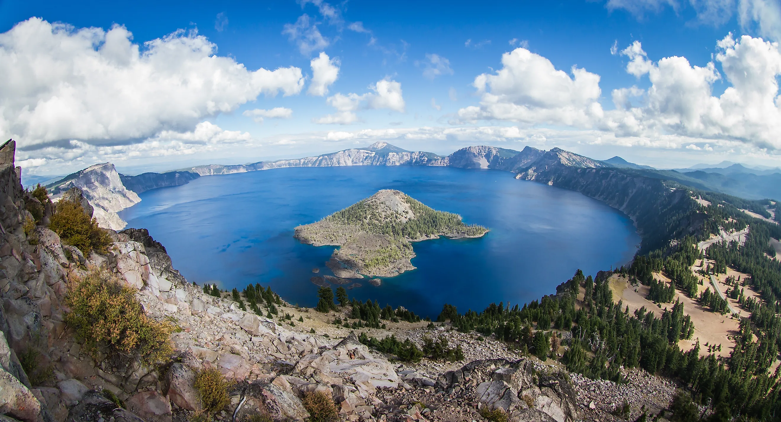
Crater Lake

Almost no other body of water in the United States presents a cleaner, more compelling geological story than Crater Lake. Formed after the collapse of Mount Mazama about 7,700 years ago, this caldera holds the title of deepest lake in the nation, reaching 1,943 feet at its deepest point. Though it is perhaps best known for its unusually clear, intensely blue waters, with sheer cliffs ringing the shoreline that rise sharply above the surface, giving the lake a contained, almost isolated feel. Wizard Island, a cinder cone within the lake that rises about 760 feet, adds another distinct focal point and can be reached by boat in summer.

If you plan on visiting Crater Lake National Park, note that seasonal snow often lingers well into early summer, limiting access but preserving the stark, high-elevation setting that contrasts with the surrounding volcanic landscape. For the best way to tour during good weather conditions, Rim Drive is an auto route that provides multiple viewpoints, each offering a slightly different perspective on the lake's depth, color, and adjacent terrain.
Columbia River Gorge

The Columbia River Gorge cuts a deep, 80-mile corridor right through the Cascade Range, forming one of the largest river canyons in North America. Designated as a National Scenic Area in 1986, it marks the boundary between Oregon and Washington, and is known for funneling strong west-to-east winds, making its waters a hotspot for kite surfing and windsurfing.
For sightseers, the gorge contains more than 90 documented waterfalls on the Oregon side alone, including Multnomah Falls, which drops a total of 620 feet in two tiers, making it the tallest waterfall in the state.

Elevation shifts from near sea level to over 4,000 feet along the gorge, creating distinct climate zones within a relatively short distance. Basalt cliffs formed by ancient lava flows dominate much of the landscape near the rims, while lush woodlands and meadows can be found closer down below near the banks of the Columbia River as you approach Portland.
Wherever you stop, numerous viewpoints along the Historic Columbia River Highway provide direct access to several other major falls, trailheads, and overlooks.
Painted Hills

The Painted Hills of eastern Oregon are one of three units within the John Day Fossil Beds National Monument, known for their vibrantly layered bands of red, gold, black, and green soils. For geology fans looking to understand how they came to be like this, these colors reflect different climate periods dating back roughly 35 million years, when the region shifted between humid, tropical conditions and drier environments.

The hills are composed primarily of claystone, which changes appearance depending on light and moisture levels. Fossil evidence from the broader monument notably includes early mammals such as brontotheres and oreodonts.
Public access is limited to designated trails to reduce erosion, including the Painted Cove Trail and Carroll Rim Trail. Keep in mind that the site is most visually distinct in early morning or late afternoon light, when sunrise or sunset causes the colors to contrast the strongest for the optimal landscape photo.
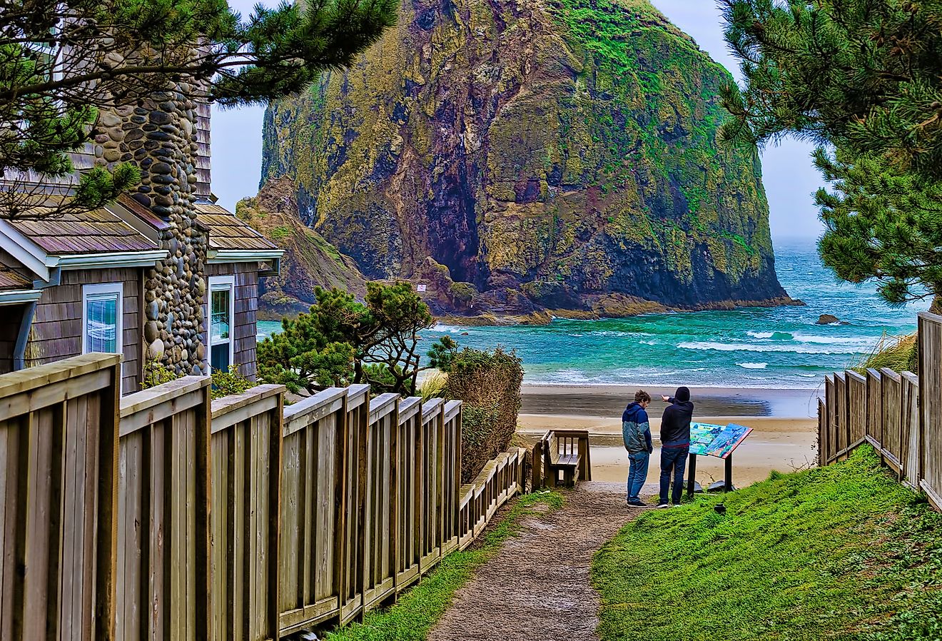
Thor's Well

Along Oregon's lengthy coast, Thor's Well functions as a sort of natural ocean drain carved into the shoreline. Located near Cape Perpetua Scenic Area, about 82 miles directly west of Eugene, this unique feature is essentially a collapsed sea cave, with a hole that connects directly to the Pacific through underground channels. The visible opening measures roughly 20 feet across, though the depth varies with tide conditions.
At high tide or during storms, incoming waves force water up through the opening before it surges back down, creating a continuous cycle of inflow and outflow. Timing matters if you'd like to see this wonder in action; visiting about an hour before high tide typically produces the most consistent activity without fully submerging the formation. Remember that the surrounding rock platform is uneven and often slick, with strong surf capable of sweeping water far inland.
Smith Rock

Smith Rock State Park encompasses another volcanic landscape, this time defined by steep cliffs that are world-famous for climbing, deep river canyons that see regular whitewater use, and exposed rock formations rising abruptly from the high desert. The area is widely regarded as the birthplace of modern American sport climbing, with hundreds of established routes here catering to a variety of skill levels.
The Crooked River cuts through the park, creating walls that reach up to 600 feet in height, with the dominant rock type here, called "welded tuff," formed from compressed volcanic ash that dates back roughly 30 million years. Monkey Face, a 350-foot spire, stands as the park's most recognizable formation and a must-see even for casual visitors.
Even if you don't have climbing gear but good shoes instead, try exploring a bit more in depth via trails such as Misery Ridge, which gains elevation quickly but offers direct views into the canyon and across the surrounding plateau. The dry climate and open terrain make visibility consistent throughout most of the year. Just bring lots of water and sun protection, especially in the often scorching summer months.
Oregon Dunes National Recreation Area

Stretching roughly 40 miles along the coastline, the Oregon Dunes National Recreation Area contains the largest expanse of coastal sand dunes in North America. Formed over thousands of years from sediment carried by the Umpqua, Siuslaw, and Coos Rivers, these dunes can reach heights of up to 500 feet above sea level.
The area lies within the Siuslaw National Forest and supports a range of plant species adapted to the shifting sand, including shore pine and European beachgrass. Wind patterns constantly reshape the terrain here, creating a mix of open sand, forested islands, and seasonal wetlands that are easy to explore and can offer differing experiences with repeated visits.
Public access points near Florence, Reedsport, and Coos Bay lead to designated hiking routes, day-use zones, and dune buggy/OHV areas, with some sections restricted to protect sensitive habitats.
Silver Falls State Park

Silver Falls State Park, just outside Salem, boasts a concentration of waterfalls that makes it one of the most scenic yet accessible natural attractions in Oregon. The park contains 10 named waterfalls along a single loop, aptly known as the Trail of Ten Falls, which runs about 7.2 miles. They typically maintain a steady flow through much of the year, with peak volume occurring in late winter and early spring after seasonal rainfall and snowmelt.
Most of the cascades are fed by Silver Creek, cutting through layers of local basalt and creating a series of overhangs and recessed amphitheaters. South Falls drops 177 feet and includes a path that passes directly behind the curtain of water, while North Falls follows at 136 feet, also allowing behind-the-falls access.
See The Natural Beauty Of Oregon In 2026
Oregon exemplifies the Pacific Northwest, with its amazing blend of diverse landscapes and the plethora of state and national parks protecting them. If you are unsure of where you want to travel this year, then perhaps these destinations will satisfy the urge to see what many consider to be some of the greatest natural wonders the United States has to offer.