7 Best Natural Wonders To Visit In Michigan This Year
With about 3,300 miles of Great Lakes shoreline, the longest freshwater coastline of any state in the country, Michigan has built its identity around water. The natural landmarks that follow run the full range of what that setting produces, from the 450-foot dunes of Sleeping Bear to the underwater clarity of Kitch-iti-kipi, from the iron-stained cliffs of Pictured Rocks to the island wilderness of Isle Royale. These are the seven natural wonders worth building a Michigan trip around.
Pictured Rocks

Pictured Rocks National Lakeshore is perhaps the most iconic landscape in Michigan, one that any resident or visitor should experience at least once. Stretching 42 miles along Lake Superior, this protected shoreline is home to sandstone cliffs that rise up to 200 feet above the lake, stained in bands of iron, copper, and manganese mineral leaching. Wind, ice, and wave action have come together over thousands of years to carve a collection of arches, sea caves, and narrow coves that shift in character as the light moves throughout the day. Water clarity here is unusually high as well, giving the lake a cold, blue depth that feels closer to an ocean coast than the other Great Lakes.
In summer, kayak routes trace the base of the cliffs, passing formations like Miners Castle and Chapel Rock. In winter, however, the same cliffs freeze into curtains of ice, drawing experienced ice climbers. If you'd like to stay inland, a network of trails leads to various overlooks and waterfalls, including Munising Falls.
Porcupine Mountains

Rising above Lake Superior's southern shore, Porcupine Mountains Wilderness State Park protects one of the largest remaining tracts of old-growth hardwood-hemlock forest in the Midwest. The terrain is defined by rugged ridges, steep river valleys, and dense stands of hemlock and sugar maple, more reminiscent of what you'd find along the northern Appalachians than typical Midwest woodland. Some trees in the park are over 300 years old.
Try the Escarpment Trail for the signature view, which delivers a sustained overlook of Lake of the Clouds, a glacial basin framed by forested slopes. More than 90 miles of other hiking routes cross the park, including backcountry paths that pass waterfalls along the Presque Isle and Big Carp Rivers. Wildlife sightings regularly include black bears and white-tailed deer, with the occasional moose, so bear spray, keeping a healthy distance, and a camera are essential for in-depth exploration.
The seasons in the Porcupine Mountains are pronounced, with summer great for camping and canoeing, fall bringing tons of colorful foliage across the hardwood canopy, and winter turning the interior trails into a peaceful, snow-covered wonderland perfect for snowshoeing.
Sleeping Bear Dunes

Rising dramatically above Lake Michigan, the Sleeping Bear Dunes National Lakeshore is home to a series of massive dunes that climb more than 450 feet above the water at their highest point. These formations were built by glacial deposits and are regularly reshaped by persistent wind, creating steep faces and shifting ridgelines.
The Dune Climb provides the most direct access to the sands, while the Pierce Stocking Scenic Drive loops past key overlooks and trailheads. From the bluffs, views extend across the Manitou Islands and long stretches of undeveloped coast. Inland, you'll find mixed forests, wetlands, and interior lakes that add variety beyond the dunes themselves.
Note that exploring on foot can be physically demanding, as loose sand, exposure, and rapid elevation changes make even short distances more strenuous than they appear on a map. Visitors who descend the dunes toward Lake Michigan may find the climb back extremely difficult, and rescue responses at Sleeping Bear Dunes can cost up to $3,000.
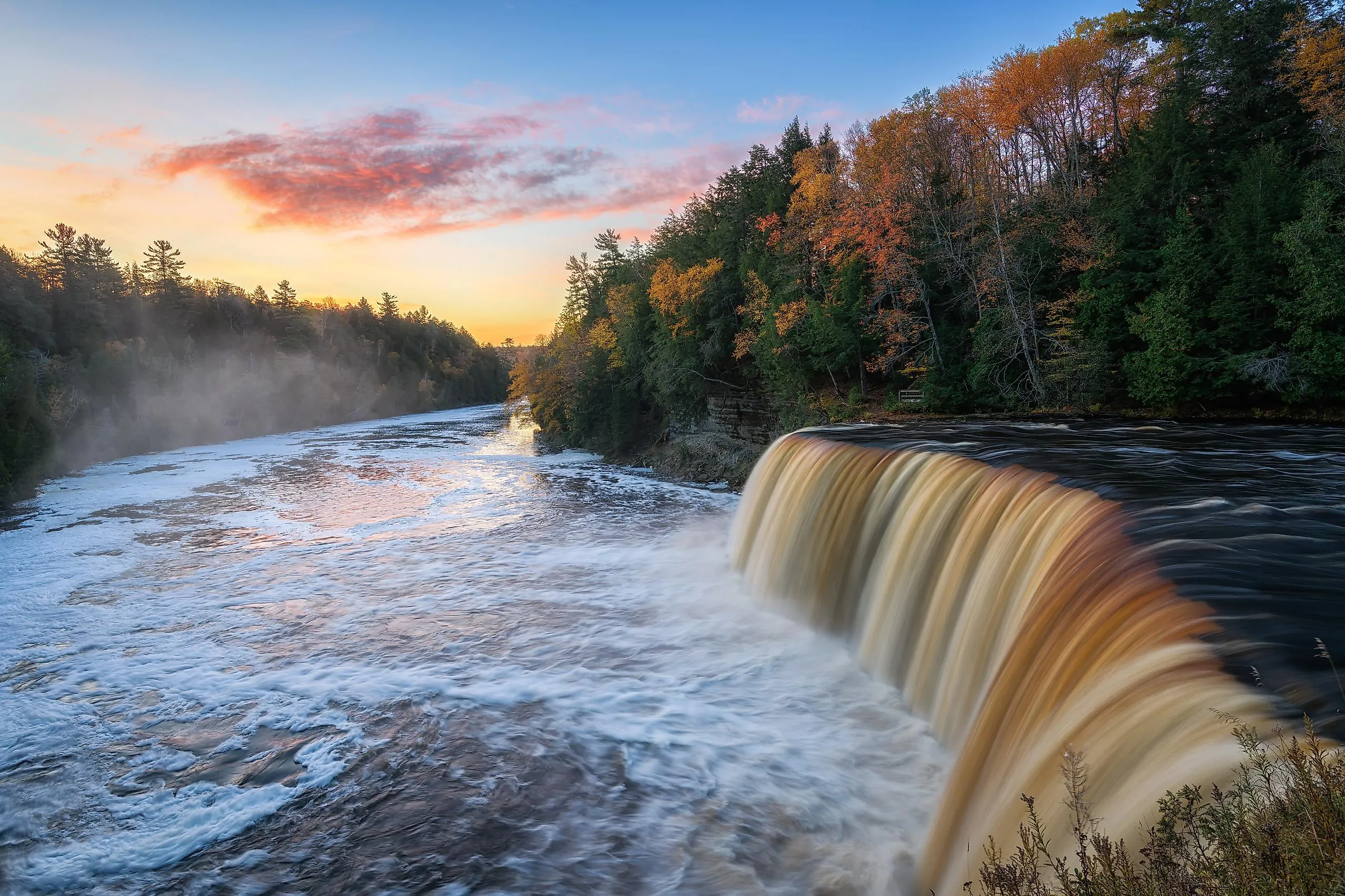
Tahquamenon Falls

Set deep within the forests north of Lake Superior, Tahquamenon Falls State Park centers on the largest waterfall system in Michigan. The Upper Falls span roughly 200 feet across with a drop of about 48 feet, pushing a steady volume of water that is tinted amber by natural tannins from cedar swamps upstream. Four miles downstream, the Lower Falls split around a central island, creating a broader, more segmented cascade. A network of trails and boardwalks connects both sections, with access points to the river for canoeing and kayaking.
Flow remains strong year-round, though seasonal changes affect the river's depth and speed. The fall months are marked by foliage that surrounds the falls in red, orange, and yellow, making it an excellent time for landscape photography. Winter conditions often freeze sections of the falls, forming thick ice structures along the riverbanks.
Kitch-iti-kipi

Hidden within a dense forest inside Palms Book State Park, Kitch-iti-kipi is Michigan's largest natural freshwater spring, measuring about 200 feet across and 40 feet deep. Fed by underground aquifers, it releases more than 10,000 gallons of water per minute, keeping temperatures near 45°F year-round. Even in winter, the constant flow prevents the spring from freezing over completely.
The water of Kitch-iti-kipi is exceptionally clear, revealing sand boils where pressure forces groundwater upward, submerged tree trunks, and cruising fish. You can cross this picturesque pool on a hand-pulled observation raft, which allows direct viewing into the spring's depths without disturbing it. The surrounding area also remains relatively quiet, with short boardwalk trails through a cedar forest leading to several shoreline clearings.
Turnip Rock

Accessible only by water, Turnip Rock is a distinct formation off the shoreline of Lake Huron. Wave erosion has carved the sedimentary rock around it into a narrow pedestal topped by a wider, tree-covered cap, giving it the shape that defines its name.
Turnip Rock sits just offshore in the shallow, clear waters near Port Austin in Michigan's Thumb on Lake Huron, where paddling routes pass additional sea stacks and small coves. Kayak launches from Port Austin give the most direct access, with routes typically following the coastline for several miles. Also, keep in mind that the rock sits on private property and cannot legally be approached on foot; kayak access remains the only way to see it up close. Lake Huron conditions can be perilous at times, and the exposed shoreline offers limited landing spots, so timing and weather awareness are important.
Isle Royale

Remote and largely untouched, Isle Royale National Park rests in the northern waters of Lake Superior near the Canadian border. The main island of Isle Royale is approximately 45 miles long, a narrow ridge of volcanic rock surrounded by hundreds of smaller islets, creating a fragmented shoreline further shaped by glaciers and Lake Superior's waves.
Boreal forests cover most of the interior, intersected by inland lakes such as Siskiwit and Richie, which are linked by portage routes used by both hikers and canoeists. The ecosystem is internationally known for its wolf-and-moose research, and the National Park Service describes it as the longest continuous predator-prey study in the world, ongoing since 1958.
Access is limited to seasonal ferry or seaplane service, and stays are typically multi-day due to the distance and isolation from the mainland. Come prepared, as trails here are rugged, and services are minimal.
See The Natural Attractions Of Michigan Today
Michigan's natural landmarks range from inland springs to exposed coastlines and remote island wilderness, and each site reflects different geological forces shaped by glaciers, water, and time. Together, they form a landscape with real variation, where access often requires effort and know-how. Visiting them is less about spectacle alone and more about observing the distinct environments this often unsuspecting state has to offer.