What Causes Tectonic Plates To Move?
- Tectonic plates are 62 miles thick and are made up of the continental crust and the oceanic crust.
- Slab pull is the most relevant force that affects the movement of tectonic plates.
- Convection refers to specific cells within the Earth’s mantle that create heat. The heat makes the solid rocks move upwards while the colder rocks move downwards.
Earth's outer shell is split into about 15 rigid pieces, and all of them are moving. The movement happens at roughly the speed your fingernails grow (one to fifteen centimeters per year, depending on the plate), which sounds slow but adds up to thousands of kilometers across geological time. GPS stations measure the drift directly today, so the existence of the movement is not in doubt. The interesting question is why the plates move (what physical force is powering the motion), and the answer has shifted in scientific consensus over the past several decades. Three forces are usually identified, but the current consensus assigns most of the work to one of them: slab pull, the weight of cold oceanic plates sinking back into Earth's mantle at subduction zones.

What a Tectonic Plate Actually Is

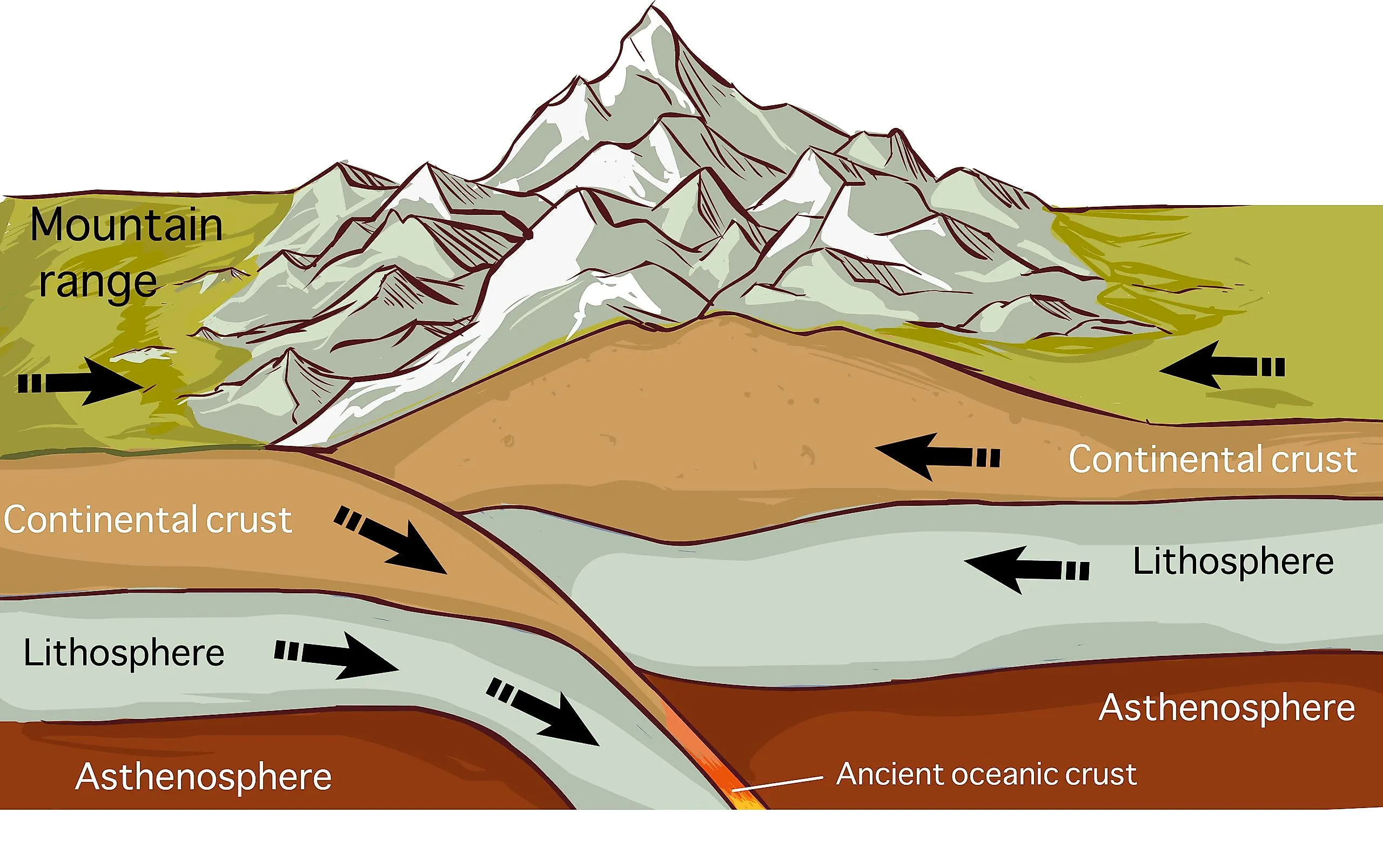
A tectonic plate is a section of Earth's outermost rigid layer, called the lithosphere. The lithosphere combines the crust (the top few kilometers, made of familiar crustal elements) and the uppermost cold, brittle portion of the mantle below it. Most popular descriptions identify plates with the crust alone, but this is not quite right: the plates are crust plus the rigid top of the mantle, which together act as a single mechanical unit floating on the hotter, more deformable asthenosphere underneath. Lithospheric thickness varies considerably, not the flat figure sometimes quoted: young oceanic lithosphere near mid-ocean ridges is only about 10 kilometers thick, old oceanic lithosphere far from ridges reaches about 100 kilometers, and stable continental lithosphere can extend 150 to 250 kilometers deep beneath ancient cratons such as the Canadian Shield. The often-cited 100-kilometer average is a useful rough number that hides this large range.
Earth has about seven major plates (the Pacific, North American, South American, African, Eurasian, Antarctic, and either the combined Indo-Australian Plate or the Indian and Australian Plates as separate units, depending on classification) plus a varying count of eight to fifteen minor plates including the Nazca, Cocos, Juan de Fuca, Caribbean, Arabian, Philippine Sea, and Scotia. The boundaries between these plates account for the world distribution of earthquakes, volcanoes, and mountain ranges; about 90 percent of all earthquake energy and roughly 80 percent of active volcanism happen along plate boundaries.
The Three Driving Forces

Three forces, working at different depths and locations, together explain why the plates move. The first is mantle convection, the broad and slow circulation of heat within Earth's mantle: hot material rises from near the core-mantle boundary, spreads beneath the lithosphere, cools, and sinks back down to be reheated. Convection was the dominant explanation for plate motion from the 1960s through the 1980s, with researchers picturing the plates as passive passengers riding on top of mantle convection cells in something like a conveyor-belt arrangement.
The second force is ridge push. At mid-ocean ridges (the underwater mountain ranges that mark divergent plate boundaries), the seafloor sits topographically higher than the older crust on either side because newly erupted basalt is hot and buoyant. As that hot basalt cools and contracts moving away from the ridge, gravity pulls the surrounding lithosphere downhill, producing a sideways shoving force away from the ridge axis. The Mid-Atlantic Ridge is the textbook example; it runs the length of the Atlantic Ocean and is currently widening the Atlantic by about 2.5 centimeters per year.
The third force is slab pull. When old oceanic lithosphere reaches a subduction zone (where one plate dives beneath another), it has had time to cool and become denser than the underlying mantle, and it begins to sink. Once the descending slab is roughly 50 to 100 kilometers down, it pulls the rest of the plate behind it the way a long tablecloth gets pulled across a table when the leading edge slides off. Slab pull acts on the densest, heaviest part of the plate system: an oceanic slab descending into the asthenosphere is hundreds of kilometers long, weighs trillions of tons, and gravity drags it downward continuously.
Why Slab Pull Now Leads the Argument
The shift in scientific consensus toward slab pull as the dominant driver happened gradually from the late 1980s through the early 2000s, supported by several converging lines of evidence. Plates with the largest attached subducting slabs (Pacific, Nazca, Cocos) consistently move the fastest, while plates without significant subducting slabs (Antarctic, African, Eurasian) move the slowest, a correlation predicted by the slab pull model and confirmed by modern GPS measurements. Numerical models of mantle dynamics suggest slab pull contributes roughly 80 to 95 percent of the net force budget on most plates, with ridge push contributing a smaller share and broad mantle convection acting more as a background condition than a direct push. The two earlier candidate forces are not eliminated; researchers think they still contribute, but the slab does most of the heavy lifting. Some researchers argue the distinction is partly semantic, since the descending slab is itself an expression of mantle convection (it is the cool, descending limb), but the consensus terminology now treats slab pull as the principal driving mechanism.
How Fast Plates Actually Move

Plate speeds vary by an order of magnitude across the planet. The Pacific Plate is the fastest of the major plates, moving roughly 7 to 11 centimeters per year toward the northwest, which works out to about the speed at which human fingernails grow. The Australian Plate is also unusually quick at roughly 7 centimeters per year. At the slow end, the Antarctic Plate moves under 2 centimeters per year and the African Plate moves at roughly 2 to 3 centimeters per year. Over geological timescales these speeds add up: India has moved about 2,000 kilometers north since separating from Antarctica around 130 million years ago, and the collision between the Indian and Eurasian Plates is still raising the Himalayas at several millimeters per year (Mount Everest's official height was revised slightly upward to 8,848.86 meters in the joint 2020 Nepal-China survey, reflecting in part the continued tectonic uplift).
You can watch plate motion happen at human time scales in a few places on Earth. The Mid-Atlantic Ridge passes directly through Iceland at Þingvellir National Park, where North America and Eurasia are separating at about 2.5 centimeters per year; visitors can walk through a rift valley with one foot effectively on each plate. The San Andreas Fault in California is the boundary between the Pacific Plate moving northwest and the North American Plate moving more slowly south; over the past 20 million years, this has shifted Los Angeles roughly 300 kilometers north relative to a stationary North America, and at current rates Los Angeles will be at the latitude of San Francisco in roughly 25 million years.
How Geologists Figured This Out
The modern theory of plate tectonics came together in the 1960s after decades of accumulating evidence. The German meteorologist Alfred Wegener proposed continental drift in 1912, pointing to the matched coastlines of South America and Africa, identical fossil species on different continents, and similar rock formations on either side of the Atlantic; he was met with widespread skepticism because he could not explain what physical force was moving the continents. The breakthrough came from seafloor mapping during and after World War II, which revealed the global mid-ocean ridge system (a continuous underwater mountain range about 65,000 kilometers long winding through every ocean) and the deep ocean trenches alongside subduction zones.
American geologists Harry Hess and Robert Dietz proposed seafloor spreading in the early 1960s, arguing that new oceanic crust forms at mid-ocean ridges and moves outward toward subduction zones where it sinks back into the mantle. The decisive confirmation came from paleomagnetism: striped patterns of magnetic polarity in seafloor basalt, symmetric on either side of mid-ocean ridges, recorded the periodic reversals of Earth's magnetic field as new crust formed and cooled at the ridges. Once seafloor spreading was confirmed, the rest of plate tectonics fell into place quickly, with the unified theory in place by about 1968 and now considered one of the foundational discoveries of 20th-century earth science.
What Plate Tectonics Has Built (And Where It Is Going)
Plate tectonics has been the dominant force shaping Earth's surface for at least the last 2 to 3 billion years, building every major mountain range, opening and closing every ocean basin, and concentrating most of Earth's earthquakes and volcanoes along plate boundaries. The Atlantic Ocean is currently growing about 2.5 centimeters wider each year while the Pacific shrinks at roughly the same rate as the Pacific Plate is consumed at its various subduction zones around the Pacific Ring of Fire. Looking far ahead, geophysical models predict that the present plate configuration will eventually reassemble into a new supercontinent (variously called Pangaea Ultima, Pangaea Proxima, or Amasia depending on the model) somewhere between 200 and 300 million years from now, completing roughly the seventh supercontinent cycle since plate tectonics began. From the perspective of slab pull, every one of these long-term changes is ultimately driven by gravity acting on cold, dense oceanic plates sliding back into the mantle that originally produced them; the planet, in effect, keeps refreshing its own outer skin.