The National Parks Hiding Old Mines And Ruins
The Park Service counts roughly 38,000 abandoned mineral sites across the whole system it manages, a system that runs well beyond the 63 national parks. Plenty of that inheritance sits inside the parks themselves, which were drawn around country where somebody was already digging. Congress protected the scenery, and the workings came with it. What you'll find now depends on the choice the Park Service made at each one. A timber mill in Alaska got braced. A uranium headframe above the Grand Canyon got taken down. Elsewhere, shafts were sealed, buildings stabilized, and entire mining districts left in place as reminders that these landscapes were once working ground before they became protected.
Wrangell-St. Elias National Park and Preserve, Alaska

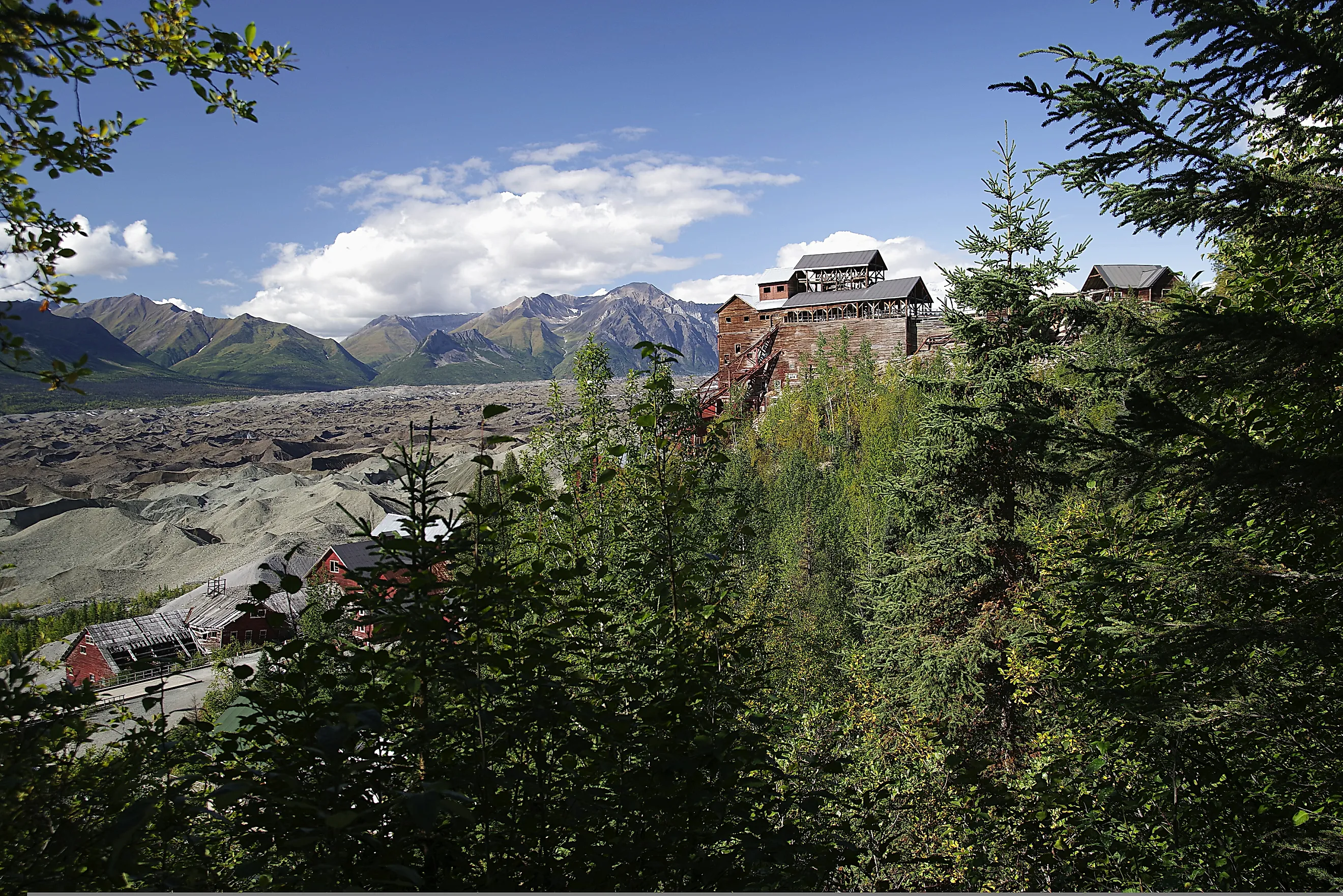
The Kennecott mill in Wrangell-St. Elias National Park, Alaska.
The Kennecott concentration mill climbs 14 floors of braced timber up the mountainside, put together where almost nothing else was. Ore reached it through 77 miles of underground tunnel and three aerial tramways running 6 miles in total. The railroad that carried the copper out included 44 miles of bridges and trestles. Many of them washed away every spring and had to be rebuilt before the next season. The first trainload left for Cordova in April 1911.
The company also pioneered ammonia leaching here, the first plant of its kind anywhere, a chemist's solution to rock too poor for any earlier method to bother with. Peak employment ran 500 to 600 men on three 8-hour shifts. When the operation closed in 1938 it had taken out copper worth $200 million at the prices of that year. Five mines fed the mill, called Bonanza, Jumbo, Mother Lode, Erie, and Glacier.
Then the company left, and the buildings stayed as they were. The Park Service bought 2,839 acres inside Wrangell-St. Elias National Park and Preserve in 1998, taking in much of the mill town and the subsurface rights. Arsenic and lead in the old paint, and asbestos in the insulation, have since made the mill town a Superfund cleanup as much as a preservation project, with environmental investigations running from 2015.
Mammoth Cave National Park, Kentucky

Nine leaching vats survive underground at Mammoth Cave, along with two collecting tanks, part of a pump, and roughly 50 sections of wooden water pipe. Federal survey documentation calls the assembly the most complete known example of equipment for processing cave saltpetre. Constant temperature and humidity did the preserving. Wood that would have rotted above ground has held together for more than 200 years.
Saltpetre is the principal ingredient of black gunpowder. Thousands of years of bat guano had left the cave dirt rich in the nitrate that yields it. During the War of 1812, Charles Wilkins of Lexington and his partners ran the works on the labor of roughly 70 enslaved men. They hauled dirt by ox-cart to vats in the Rotunda and flooded it with water piped in by gravity. The solution went back up to the surface for boiling.
Everything shut around 1815, when the war ended and the price collapsed. Mammoth Cave is unusual for where that equipment remains. The modern tour trail runs directly past the vats and the pump tower. Visitors do not find the industrial wreckage behind a fence. They walk right past it.
Great Basin National Park, Nevada

Alpine cabin in Great Basin National Park under a starry sky.
The Johnson Lake Mine sits almost 11,000 feet up the Snake Range in Great Basin National Park, high country that miners climbed into for tungsten. The ore was milled on site, then hauled a long way out for refining into alloy steel. That steel went into weapons, tanks, and transmitter radios during the First World War. Work ran on and off after the armistice. A snowslide swept over the diggings in the 1930s, and production stopped for good.
Nobody cleaned up afterward. Log cabins, scattered equipment, and the remnants of an aerial tramway are what the Park Service inherited, and much of it has simply been left in place. Most of the machinery had already gone, salvaged for other mines or carried off by collectors before the park existed.
Reaching the district takes an 8-mile round trip from the Snake Creek trailhead and 2,520 feet of climbing, which is part of why so little has been disturbed. Several cabins are still upright after roughly a century of avalanche, blizzard, and rockfall.
Denali National Park and Preserve, Alaska

Two bears on a tree stump in Denali National Park.
Mining continued in the Kantishna Hills of Denali National Park and Preserve until 1985. Gold turned up in 1903, when James Wickersham found it in the northern hills returning from an attempt on the mountain. More appeared on Friday and Eureka creeks the following year. Several thousand prospectors came north into interior Alaska behind the news.
Most left by early 1906, once it was clear that only a few streams carried paying quantities. The operations that stayed grew heavier with each passing decade. Later miners bulldozed streambeds to move gold-bearing gravel. The Park Service describes the result plainly: holes in hillsides, floodplains that no longer worked, and streams cutting down through their own banks and tailing piles.
Repairing those creeks took a major effort, so the creeks have been repaired while the buildings were kept. The Kantishna Roadhouse is the oldest standing building in the park. Nearby, the yellow frame house where Fannie Quigley lived, built around 1938, joined the National Register in December 2019.
Joshua Tree National Park, California

A visitor admiring the view in Joshua Tree National Park.
Prospectors sank more than 300 mines into the country that is now Joshua Tree. They were chasing gold, with silver and copper as secondary prizes, and very few of the claims paid. The Lost Horse Mine did for a while, yielding roughly 10,000 ounces of gold. Johnny Lang had bought the claim for $1,000 and taken in three partners to help hold it. A Montana rancher named J.D. Ryan bought all four out in 1895.
The miners hit a fault in 1905 and lost the ore vein permanently. Mill and shafts remain on the hillside, 4 miles there and back from the trailhead, though visitors are asked to stay outside the fence.
Abandoned openings on that scale pose a serious risk of injury, and the closures reflect that. Crews have sealed shafts with bat gates, cupolas, and fencing, which keeps people out while letting bats keep using the tunnels. Some gates are set about 20 feet back from the entrance. A visitor still gets the feeling of standing inside a mine.
Mount Rainier National Park, Washington

Mount Rainier National Park in Washington state.
The Mount Rainier Mining Company promised its investors copper in Glacier Basin, and that promise was most of what it ever produced. Claims went in from 1902 at the head of the White River valley below Mount Rainier, served by a tramway, work buildings, and an access road. Rangers who later went through the paperwork found the miners had extracted very little ore. The owners were convicted of defrauding investors.
Congress shut the door in 1908 with legislation preventing further mining claims inside the park. The surviving claims were bought back slowly across the following decades. Ownership changed hands more than once, and some work carried on into the 1950s before the venture proved unprofitable.
What separates this site from the others is that no agency ever decided its fate. Rockslides, cave-ins, and snow destroyed the buildings and the workings without help. Hikers on the Glacier Basin trail pass what little remains.
Virgin Islands National Park, Saint John

Annaberg Plantation windmill, USVI. Editorial credit: Pi3.124, CC BY-SA 4.0, via Wikimedia Commons
The ruin at Annaberg came from sugar, not ore, and the machinery was a windmill rather than a headframe. Frederick Moth owned several plantations on the island in the 1720s and 1730s. He served as the first Danish Governor of Saint Croix and later as Governor General of the Danish West Indies. Annaberg had become one of the island's largest sugar producers by the early 19th century, shipping molasses and rum as well.
The ground was under cultivation by 1731, though the stone buildings standing today probably date from the 1820s or 1830s. The windmill tower, the factory, and the animal mill all remain. So do the quarters of the enslaved people who worked them, linked by a short trail with interpretive waysides. The interior of the windmill is closed.
Annaberg is the most accessible historic site the park maintains on Saint John. The Park Service interprets it directly, using the sugar trade to explain the brutality of slavery and colonialism rather than presenting old stonework as scenery.
Carlsbad Caverns National Park, New Mexico

Bats take flight at Carlsbad Caverns National Park. Editorial credit: CarlsbadCavernsNPS, Public Domain, via Wikimedia Commons.
Early visitors rode into the cavern in a guano mining bucket. Bat guano is nitrate-rich fertilizer, and miners were hauling it out of Bat Cave at Carlsbad Caverns in the early 1900s, well before anyone thought of protecting the place. The same bucket that lifted their loads doubled as the lift that lowered sightseers into the dark.
That arrangement lasted until 1925, when the Carlsbad Chamber of Commerce donated a staircase running down from the natural entrance and the bucket went out of service. The haul road outlasted the bucket. A backcountry trail now follows it for 3.7 miles, dropping 710 feet from the dirt track beside the natural entrance. Ruins and debris from the operation stay obvious for the first mile.
Here the mine did not survive alongside the attraction. It became the attraction. Rangers describe the sequence as a shift from frontier, to guano mining area, to premier show cave. Federal protection followed quickly: a national monument in October 1923 and a park in May 1930.
Canyonlands National Park, Utah

Shafer Trail in the Canyonlands National Park Utah.
The Shafer Trail carries traffic down 1,500 feet of sandstone today, and it runs that wide because trucks once hauled uranium ore up it. The government wanted uranium stockpiled in the 1950s, and geologists believed southeast Utah held a great deal of it where nobody could reach. The Atomic Energy Commission recruited an army of prospectors and built the access they needed.
The commission widened the Shafer Trail and pushed it through to the White Rim Road, so loaded trucks could reach the processing works at Moab. A photograph of a claim near Airport Tower dates to January 1965, four months after Congress made the country around it Canyonlands National Park.
Almost nothing industrial survives, which leaves no mill to stabilize and no headframe in dispute. What remains is the road network itself, still carrying traffic. Seen from Grand View Point, only one of those prospecting roads is still legible. Brush and desert growth cover the rest.
Grand Canyon National Park, Arizona

The South Rim Trail detours around a 20-acre parcel between Maricopa Point and the Powell Memorial. The Orphan Mine occupied that ground on the south side of the Grand Canyon. Dan Hogan registered the Orphan Lode there in 1893 as a copper claim, 1,000 feet below the rim, then cut a trail down the cliff face to reach it.
The value of that parcel came from uranium. Geologists identified a high-grade deposit on the site in 1951. A private company took over by 1956, and an aerial tram began lifting ore from the workings below to the rim above. The tram gave way in 1959 to a vertical hoisting shaft under a steel headframe, which stood visible from the rim for the next decade. Production ran until 1969 and yielded upward of 4 million pounds of uranium oxide.
Nothing was reclaimed when the company walked away. The Park Service finished removing the surface equipment and debris in 2009, which is why no headframe breaks the skyline above the canyon now. Here the agency chose erasure.
What The Park Service Chose To Keep
One question produced ten different answers. At Mammoth Cave the wreckage sits on the tour route; at Great Basin the cabins are left to the weather. Rangers sealed the shafts at Joshua Tree and repaired the creeks at Denali, and at Canyonlands the roads stay in use while the reason for them fades. At Mount Rainier no one had to decide, because the avalanches got there first. Only at the Grand Canyon did the agency haul the machinery away.